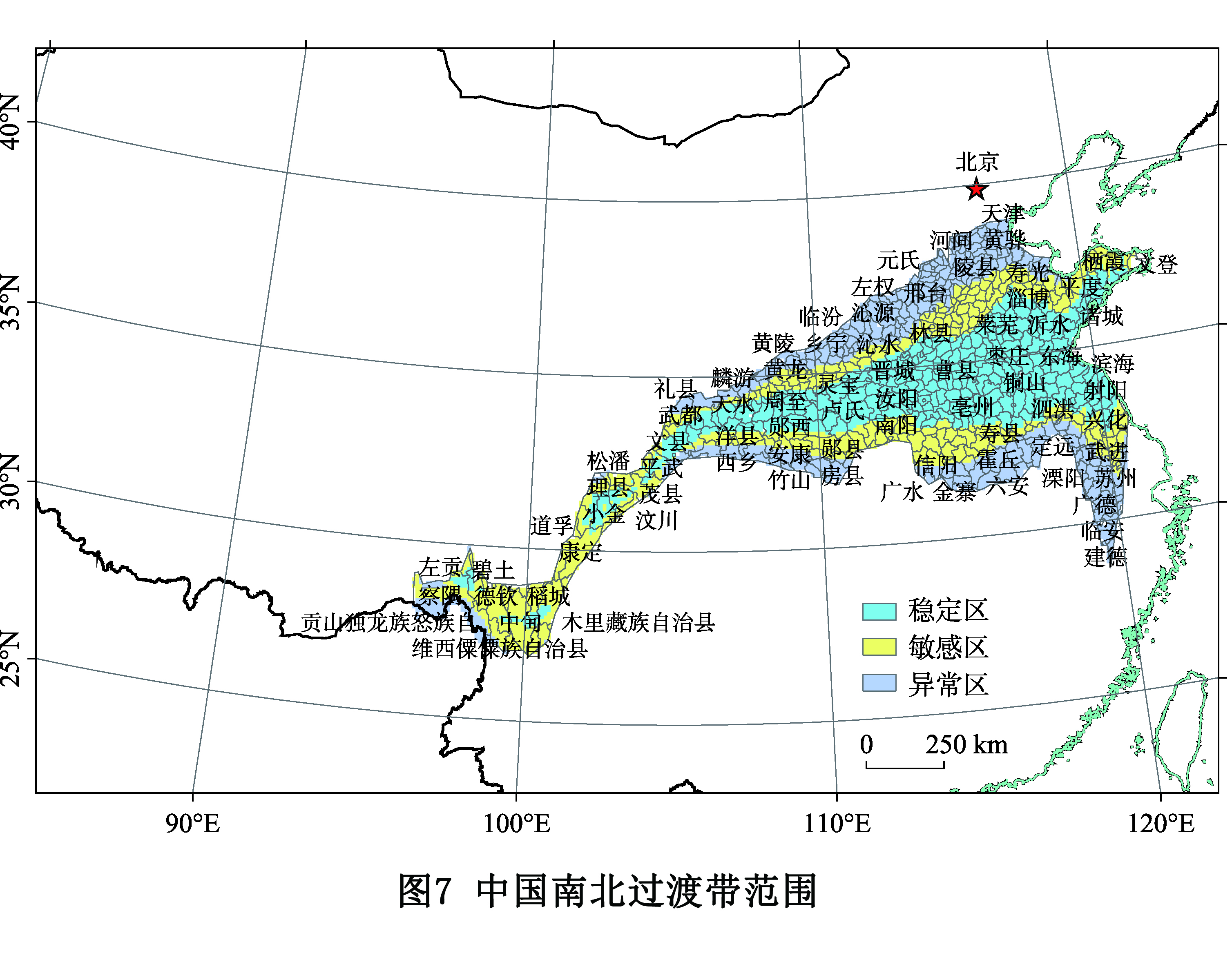
Under the climate change, the dynamic change of China′s north-south transitional zone and the detection of its regional scope are the basis of identifying the sensitive areas of agricultural production and studying the adaptive behavior of agriculture. Based on the "top-down" or "bottom-up" method, the predecessors used different demarcation indicators to explore the scope of the north-south transitional zone in China. However, the geographical expression and quantitative detection of the range of the China′s north-south transitional zone under climate change are rarely involved. The daily observation data of temperature and precipitation of more than 2400 national meteorological stations from 1951 to 2018 are used. The 800 mm precipitation isoline, the 0℃ average temperature of January, the accumulated temperature with daily average temperature ≥10 ℃, the number of days with daily average temperature ≥ 10 ℃ and the aridity index are used as the demarcation indexes. The ArcGIS grid calculation and the mean standard deviation are used to explain the geographic expression of the China′s north-south transitional zone. The results show that the boundary between the north and the south of China is a transitional zone with different widths. The isolines of each demarcation index change obviously under the climate change. The general range of variation of each meteorological element in the southwest is more stable than that in the northeast. The range of change of accumulated temperature with daily average temperature ≥ 10 ℃ and aridity index is greater than that of the 800 mm precipitation isoline and that of the 0 ℃ average temperature of January. The northernmost boundary of China′s transitional zone passed through Lixian, Yaoxian, Hancheng, Anze, Shexian and Jinghai counties from west to east. The southernmost boundary of China's transitional zone passed through Beichuan, Ningqiang, Xixiang, Fangxian, Xichuan, Luoshan, Shangcheng, Dingyuan and Lin'an counties from west to east. Among the 637 counties extracted in this area, 256 counties are located in the climate change stable area of the north-south transitional zone, while 187 counties are located in the climate change sensitive area. The research can provide scientific basis for agricultural production in the north-south transitional zone to adapt to climate change in China.
Gully is characterized by the frequent material exchanges and strong morphological changes in the Loess Plateau. Under the combined action of internal and external forces, various kinds of gullies in different development stages have shaped the unique geomorphologic landscape in the Loess Plateau. And a special loess gully, namely, the spoon-shaped gully is widely distributed in this plateau. At present, there is limited research on its formation, development process, mechanism, and spatial distribution characteristics. Using high-resolution remote sensing images and DEM data, and based on the sufficient field investigation and expert knowledge, this paper put forward the concept of loess spoon-shaped gully, and pointed out that the loess spoon-shaped gully is a kind of permanent discontinuous gully independently developed on the loess slope. Then, the characteristics of loess spoon-shaped gully were analyzed from the aspects of gully shape, confluence relationship, erosion process, and distribution characteristics, which were different from other existing gullies. Furthermore, the loess spoon-shaped gully was classified from the perspectives of development morphology, development scale and development location. Based on the space-for-time substitution theory, the morphological evolution characteristics of the spoon-shaped gully were analyzed quantitatively, and the development process of loess spoon-shaped gully was further discussed. It was proved that loess spoon-shaped gully was the initial stage of loess bank gully. Finally, on the basis of systematical summary on the characteristics of spoon-shaped gullies, the development process of spoon-shaped gullies was deduced, and it was pointed out that the formation of spoon-shaped gullies was closely related to the formation and development of loess sinkholes and dark caves. The further development was accompanied by the process of hydraulic erosion and gravity erosion. The reason for the shrinkage or the disappearence of the tail of the spoon-shaped gully can be attribute to the underground caves, loess permeability, rainfall conditions and surface cover. The results of this paper are expected to contribute to the further understanding of the landform development, erosion process and mechanism of the loess gully, and to provide references for soil and water conservation in the Loess Plateau.
The inland aridification in Asia is a hot topic in paleoenvironmental research. The Badain Jaran Sand Sea is the second largest mobile sand sea in the Asian inland. It has the world′s highest aeolian landforms—megadune. Thus, it is an important carrier for the study of inland aridification in Asia. The formation and evolution of megadune are related to the environmental changes of the sand sea where they are located. Megadune recorded the regional and global climate changes. Therefore, the study on the formation and development of megadune should start from regional geology and environmental evolution. This paper expounded the formation and evolution of megadune, lakes and the sand sea itself in the Badain Jaran Sand Sea from six aspects: geological evolution, environmental evolution, sedimentology, hydrology, megadune landforms, and the formation and development of megadune. It is considered that for inland aridification in Asia tectonic/climatic events are the primary factor and the Earth′s orbital changes are the secondary factor. From the beginning of the neotectonic movement to its slowing down, tectonic/climatic events had always been the main factor controlling the climate in the Badain Jaran Sand Sea, and the Earth′s orbital changes had also played a significant role. At that time, the westerly circulation was the main driving force of the climate for these areas. After the moderating of neotectonic movement, the Earth′s orbital changes were the main controlling factor of climate in the sand sea belt of northern China. The influence of the Qinghai-Tibet Plateau on atmospheric circulation had gradually emerged. The East Asian monsoon circulation was the main driving force of climate in this region. In addition, effective moisture was controlled by summer monsoon, while winter monsoon dominated aeolian activities. These were different from the unified model under the action of westerly circulation. The paleo-source recharge hypothesis can better explain the origin of lake water. Lakes are replenished by the ancient water preserved underground through shallow underground waterways. On the macro level, lakes are wind-eroded lakes. Thus, there is no inevitable causal relationship between lakes and the maintenance of megadune. The aeolian hypothesis can better explain the formation of megadune. One of the important researches in the future will be to reconstruct the evolutionary history of megadune and sand seas and to explore the relationship between them.
Land-sea coordination is a major reform of land space planning of coastal areas. How to further promote land-sea coordination concept to deal with space planning for ecological protection, environmental management, industrial development, resource utilization and marine disaster prevention and control is an important part of integrated management of coastal areas as well as a guaranteed path for realizing high-quality development of coastal areas. In the space development and protection of coastal areas, the relations between human and land (sea), regional space relations, and the relations between land and sea are intertwined and integrated with prominent features of the complex system. Based on the flowing characteristics of substance, energy, information and elements between land and sea, the coastal zone complex system is formed by the relations between people and land (sea), regional space relations, and the relations between land and sea. On the basis of the coastal zone complex system, the interaction of the internal system and the external world can be deeply analyzed. Then, the relations between human and land (sea), regional space relations, and the relations between land and sea are integrated into the interaction in the internal complex system. Deep combination between the complex system and land space planning is realized. And the realization of land and sea planning is transformed into the coordination process of the coastal zone complex system. Researches manifest that the coastal zone complex system coordination has been deeply influenced by the flowing process of substance, energy, information and elements between the complex system and the external world and among all the subsystems. According to the development objectives and principles of the coastal zone complex system and the production and transformation process of the substances, energy, information and elements in the system, the key to the coastal zone complex system coordination lies in the three aspects: perfecting the system structure and features, adjusting the system space location and managing the content of the system output. On this basis, this paper proposes the strategy of deepening land-sea coordination in land and space planning, including constructing a new coastal zone space pattern with land and sea integrated, enhancing the protection and restoration of land-sea ecological system, promoting the development of land-sea industries in an integrative and interactive way, advancing the connection of land-sea traffic facilities and reinforcing the management of coastal zone regions in utilizing the resources and space.
Urban agglomeration is a main form of the new urbanization in a country, which means the spatial structure and organization process of urban construction land are obviously grouped. Based on the theory of community ecology, some methods, such as urban land development rate index, landscape index, kernel density estimation, were used to explore the distribution, the morphological changes and the agglomeration status of urban construction land in the Yangtze River Delta (YRD) from 1978 to 2017. This paper aims at obtaining the agglomeration pattern of urban construction land under the background of rapid urbanization. The results showed that: (1) The urban construction land in the YRD has been continuously increasing. The scale of urban construction land is gradually transferred from a low level to a high level, characterizing a hierarchic change and significant regional differentiation. The increased lands became the foundation for the development of urban agglomeration. (2) For the development process of space, the patches of urban construction land have become more clustered and balanced, and also the morphology of these patches have been changed from separated and disordered to concentrated and regular. For the agglomeration of space, the typical regions of urban construction land have gradually gathered to big cities. It gradually breaks the administrative boundaries of these cities and presents a group-like development trend, which made agglomeration evolution be essentially enhanced. (3) During the 40-year rapid urbanization, the urban construction land in the delta has experienced three important development patterns, which are independent development of a single city, clustering and symbiotic development based on the priority development of a core city, and final agglomeration with multiple groups. In this paper, the development process of the agglomeration for urban construction land in the YRD is analyzed, and the characteristics and evolution models of urban agglomeration are explored. In addition, the paper puts forward some suggestions to reshape the spatial structure system of the Yangtze River Delta urban agglomeration and optimize the layout of urban construction land, which provides a new theoretical and empirical basis for accelerating the new urbanization process and promoting the high-quality integrated development of urban agglomeration.
Urban vibrancy describes people’s interactions with urban space. And enhancing urban vibrancy is important for urban sustainable development, and thereby attracts the interest of both geography and urban researchers and policy makers. Although evidence suggests that air pollution may influence people’s out-of-home activity, few studies have quantitatively measured how air pollution depresses urban vibrancy. On the basis of Sina Weibo check-in data and daily weather and air quality data in Guangzhou in 2019 and the built environment of this city, this study compiles samples of city vibrancy in 150 neighbourhoods and 365 days, forming a strongly balanced panel dataset. By Standard Deviational Ellipse (SDE) analysis and both general and spatial panel regression models, this study examines how air pollution negatively influences urban vibrancy and the heterogeneity role of the built environment in this depression effect. Our findings demonstrate that urban vibrancy space varies across different levels of air quality index (AQI). Specifically, the size of SDEs of urban vibrancy when AQI is between 50-150 and 150-200 is about 80% and 30% of that when AQI is no more than 50. After we control the spatial dependence (i.e., spatial autocorrelation), spatial panel regression results reveal that air pollution significantly lowers urban vibrancy. The daily activity intensity decreases 0.10 times per ten kilometers with a one-unit increment in AQI. More seriously, once AQI is above 150, this depression effect grows to 0.14 times per ten kilometers with a one-unit increment in AQI. We also test the heterogeneity role of the built environment in this depression effect. The results indicate that while POI density and distance to city center increase the depression effect, the density of metro stations and interactions and land-use diversity decrease the depression effect. It is evident that the depression effect of air pollution on urban vibrancy is not evenly distributed, varying across neibourhoods with different built environment characteristics. Compared to the city center, the outskirts bear a larger depression effect. Therefore, urban vibrancy space may be more polarized when air quality deteriorates and thus, challenging urban spatial restructuring development. Our spatial panel data analysis at the neighourhood scale improves our understanding of the mechanism among air pollution, built environment, and urban vibrancy, which provides evidence-based support for built environment planning and management at the neighbourhood scale to decrease the depression effect of air pollution on urban vibrancy.
Improving the quality of living environment is an important part of high-quality urban development. The imbalance, accessibility and selectivity of facilities have a significant impact on the quality of life and emotional needs of residents. This study takes the main urban area of Lanzhou as the research object, uses the methods of mathematical modeling and ArcGIS analysis, takes POI of various urban facilities as the data source, constructs the evaluation system of residential environment deprivation to quantitatively identify the degree of deprivation, and analyzes the influencing factors. The results show that: (1) The comprehensive deprivation of residential environment in the narrow East-West River Valley presents a "core-periphery" distribution pattern with the center of gravity eastward. The high deprivation areas are concentrated in the valley edge area and the western urban area, while the low deprivation areas are distributed in valley center area and eastern urban areas. (2) The positive dimension of living environment basically presents a similar "core edge" structure in space, that is, the positive dimension of residential environment presents a trend of low deprivation in the central area of the valley and high deprivation in the marginal area of the valley, while the negative dimension is spatially opposite to the positive dimension, but there are still large differences in local areas. From the overall difference of space, the difference between medical services and urban crime environment is the largest, while that in traffic noise environment is the smallest. (3) The residential environment deprivation pattern of valley city is the result of multiple factors such as urban morphology, residential location, urban dynamic expansion, residential density and policy planning. Among them, the spatial accessibility of urban morphology restricts the development sequence of urban space, and then affects the spatial allocation level of facilities. The location of residential area restricts the selectivity of facilities and environmental interference of residential area. The dynamic expansion of city leads to the different development cycle of the valley city, and then leads to the difference of facilities allocation between new and old urban areas; the density of residential area has a certain guiding effect on the allocation of urban facilities; policy planning can reconstruct the pattern of deprivation of living environment.
In view of the serious air pollution in China, only active intervention in the built environment is simply emphasized to promote the level of physical activity of residents, but the residents may be exposed to harmful gases for a long time, which will damage the health benefits of residents. This article uses Nanjing as an example to analyze the health benefits of residents’ physical activity in traffic from an individual perspective. The study found that although physical activity is good for physical health, it should be determined according to different weather conditions. In days with good air quality, the health benefits of physical activity dominate, while in days with poor air quality, the health benefits of physical activity by residents cannot offset the harm caused by air pollution exposure. The more the activity, the higher the health risk; the health effects of physical activity in different built environments within the city are significantly different. The health benefits of traffic physical activity for residents in the old city are higher than those of the new city and the main city, and the negative health effect of air exposure in the new city is higher than that of the old city and the main city. The net health benefits of traffic physical activity of residents in the old city are greater than those of the new city, followed by the main city; the health effects of different traffic communities are significantly different, and the hot spots for the net health benefits of physical activity are concentrated in functions, convenient transportation, and green spaces and water bodies. Areas with relatively high landscape coverage, and areas close to urban arterial roads, tunnels and other complex traffic facilities and the surrounding areas of industrial parks are cold spots gathering areas for the net health benefits of physical activity. This article aims to provide a scientific reference for proposing more efficient and reasonable urban land use planning and formulating related policies.
Situ urbanization in China is considered as one of the evidences of significant changes in the human settlements system under the condition of urban-rural demarcation. Most of the existing literatures are confined to the urban-rural dualistic analysis framework. This paper established the local urbanization model on the urban-rural demarcation background, using entropy method and ArcGIS spatial analysis to examine the spatial pattern, spatial clustering and hot spot regional evolution of situ urbanization based on 108 counties (cities) in Henan province from 2006 to 2016. The conclusions are drawn as follows: (1) The results based on the entropy method show that, the level of situ urbanization has been improved significantly in most counties of Henan, but the remaining counties are still at the low level development phase, and relative difference on the level of situ urbanization is widening. (2) The results based on the ArcGIS software spatial pattern evolution show that, spatial evolution characteristics are obvious, that is, north and east Henan presents an "L"-shaped pattern in the pilot situ urbanization, and the level of urbanization in western Henan maintains is low, with distinct in-situ urbanization development trend. (3) The results of spatial autocorrelation based on Moran's I exponent show that, the spatial autocorrelation of situ urbanization in Henan is obvious, spatial clustering tendency appears, space neighbor effect is obvious, but only small scale high-clustering and low-clustering areas appear. (4) The analysis of hotspot regional evolution based on Getis-Ord G* value statistic shows that, the distribution pattern of the hot spot and cold spot areas of the province has a big change, but that of the sub-cold and sub-hot areas is basically stable. (5) Based on the maximum likelihood estimation, the empirical test results show that, the level of infrastructure construction, the scale of urban employment, the size of population and the level of county fiscal expenditure are the important factors affecting the level of local urbanization in the study area. Based on the above conclusions, this paper points out that, it is necessary to promote local urbanization construction by accelerating the reform of household registration system and employment and entrepreneurship system, perfecting agricultural land circulation and land compensation system, encouraging the development of township enterprises and accelerating the construction of new rural communities in the urban fringe.
In the process of urban development, the contradiction between the construction and operation of large-scale public infrastructure and the optimization and improvement of residential space quality has become increasingly prominent. With the continuous urban renewal, it has become the top priority of urban planning and construction to realize the win-win goal of efficient and rational use of planned land and livable and harmonious life of the people. The Beijing Capital International Airport has negative effects on surrounding residents due to its electromagnetic radiation, noise and solid pollution. As a result, it has been subject to constant complaints from residents and long-term petitions for decision. Due to the obvious negative externalities of airport facilities, its NIMBY (Not In My Backyard) has an impact on the prices of surrounding houses. This research uses the Hedonic Price Model (HPM) to analyze the impact of "distance from NIMBY facilities "on the housing price of Beijing Capital International Airport, characterizes the measurement of the spatial effects of NIMBY facilities under the influence of different factors, and analyzes the range of influence on residential prices of Beijing Capital International Airport radius. The main research conclusions are as follows: (1) The capital airport facilities have a negative impact on the price of surrounding houses. Within a certain range, for every 1% decrease in the distance to airport facilities, the price of residential houses will decrease by 0.586% on average. The influence of different factors is also different. Among them, the noise level also has a greater influence on the price of housing, with an influence coefficient of 2.145. The distance between the residence and the subway station and bus station also has a greater impact on its own price. (2) The spatial impact of airport facilities on residential prices is 10 km, and its spatial effects show a weakening trend as the "distance from the airport risk source" increases. In addition, there are 149 communities within the affected area, 83.2% of which are located in Shunyi District, and the number of affected households is approximately 130,000. (3) The spatial influence of airport facilities on NIMBY effect has different directions. The areas located to the west and south of the airport have an overall greater impact on surrounding residential prices than the areas located to the north and east of the airport.
Household registration, taken as one of the main policies to prevent the rapid growth of population in China’s megacities, is one of the main reasons for the difference between local and non-local registered residents in their jobs-housing spatial patterns. However, in-depth analysis of the differences in the formation process and mechanism of the jobs-housing spatial relationship between the two groups of residents have not been conducted yet. In this paper, we develop a new theoretical framework to empirically investigate the influencing factors, and then analyze the formation paths of jobs-housing spatial relationships from the perspective of resident perception for both local and non-local residents using Structure Equation Model based on the data from a questionnaire survey. The findings are as follows. First, Beijing registered and non-Beijing registered residents vary in their preference for housing location. Beijing registered residents are mainly concerned with the location and price of the housing, the qualities of neighbors and the accessibility of facilities such as education and medical care, while non-Beijing registered residents pay much more attention to the expenditure and area of housing, the public service and security of the residential settlements, the accessibility to the shopping mall, entertainment facilities and the subway. Second, the transmission paths of the jobs-housing spatial factors that affect the jobs-housing spatial relationship were different. For Beijing registered residents, the incomes significantly influence their housing location. The policies and institutions mitigate the positive role of jobs-housing spatial factors for non-Beijing registered residents. The sentiment and development expectations contribute to the satisfaction of Beijing registered residents with their jobs-housing spatial relationship. Third, the driving forces of the jobs-housing relationship vary across two groups of residents. The market-driven housing price and government-dominated policies and institutions significantly decrease the accessibility of jobs-housing spatial factors and jobs-housing proximity for non-Beijing registered residents. The sentiment and development expectations, which represent the individual characteristics, considerably improve the tolerance of Beijing registered residents for their long commutes. This paper concludes that Beijing and non-Beijing registered residents′difference in their jobs-housing relationships can be viewed as the results of the social re-differentiation driven by institutions, especially the household registration system, in the transition process of China′s megacities.
Cross-border and domestic mergers and acquisitions (M&As) have been playing an increasingly important role in economic globalization, industrial restructuring, and regional integration since the early 1990s. A massive number of M&As has resulted in geographical redistribution of corporate control and economic decision-making power. In contrast to the optimization of locational choice of corporate greenfield investment, the key of M&As could be regarded as the partnering, bargaining, and integration between the acquirer and the target in essence. Therefore, spatiotemporal dynamics of M&As should be investigated or measured in the following aspects: the changing spatial patterns of acquirers and targets, the shifting networks among firms and places engaging in M&As, and the effects of multiple geographical scales and spatial asymmetry. This paper constructs a spatial database of domestic M&As deals in the Yangtze River Delta (YRD). Using GIS, social network and other analytical methods, we aim to discuss the spatiotemporal dynamics of domestic M&As at regional scale (i.e. the YRD) since the mid-1990s. The results show that: (1) The acquirers and targets engaging in M&As presented significant characteristics of spatial co-agglomeration, firms engaging in M&As were mainly distributed in Shanghai and the areas along Shanghai-Nanjing (Hu-Ning) and Shanghai-Hangzhou-Ningbo (Hu-Hang-Yong) routes. The changing spatial patterns of acquirers and targets were gradually differentiated over time. Targets tended to relocate to the peripheral YRD, while acquirers still concentrated in Shanghai and other major cities. (2) City network based on inter-regional M&As has been increasingly expanding to peripheral regions, however, the leading positions of core nodes such as Shanghai, Hangzhou and Nanjing have been intensified. Meanwhile, we found significant spatial asymmetry in the M&As connections between the core and peripheral YRD, as well as metropolises and their neighboring regions. (3) The evolution of spatiotemporal dynamics of domestic M&As in the YRD has gone through three stages: I. Single core and weak network connection; II. Single core, multiple important nodes, and increasingly intensive M&As network connection; III. A complex network structure featured by multi-core and multi-level. Aforementioned descriptive results also indicate that the rapidly increasing domestic M&A activities would be significant for reshaping economic landscape and changing inter-regional relations in transitional China. In addition, this study will contribute to the literature on corporate investment networks and locational modes, and our findings might have further implications for policy-making related to M&As and regional development in transitional China and other emerging economies.
Based on land use, point of interest, socio-economic statistics and other data, this study constructs an evaluation system of rural function from five dimensions of economic development, agricultural product production, social security, ecological services and tourism and leisure, and reveals the spatial characteristics of the five functions above and their comprehensive functions of the ecological conservation area from the township scale. By means of Spearman rank correlation analysis, production possibility frontier (PPF) and trade-off intensity index and so on, the trade-off coordination relationship and the degree of trade-off between rural functions are quantitatively discussed. The results show that: (1) the spatial patterns of economic development, social security and leisure tourism functions are similar; on the contrary, the functions of economic development, social security and agricultural products production in towns with strong ecological service function are often weak. (2) There is a significant synergy relationship between economic development and agricultural production / social security function, and a significant trade-off relationship between economic development / agricultural production / social security and ecological service function. And the trade-off intensity is economic development - ecological services > social security - ecological services > agricultural production - ecological services. When it comes to the PPF curve, we can conclude that the trade-off between economic development / agricultural product production and ecological service function is similar. That is to say, the trade-off between which will be weakened while sustainably developing the ecological services. The trade-off between social security and ecological services will intensify with the continuous investment of ecological services. The synergetic effect of economic development on agricultural production (social security) function will slow down with the development of economic function. (3) According to the idea of "the less the trade-off intensity is, the symbiotic development among functions" and "the greater the trade-off intensity, the most one function can be developed". In order to maximize the comprehensive income of rural functional combination, the ecological conservation area will be divided into four types of development areas: I (four types of functional symbiosis), II (three kinds of functional symbiosis), III (two kinds of functional symbiosis) and IV (single function development). The research results will be helpful for regional rural revitalization and development planning, and provide technical support for scientific design of rural function collaborative development path.
Scientific estimation and dynamic monitoring for the development trend of carbon emissions from energy consumption with long time series can provide the scientific basis for formulating and implementing regional carbon reduction strategies. Based on the integrated DMSP/OLS and NPP/VIIRS nighttime light datasets, this study simulated the spatial and temporal characteristics of energy-related carbon emissions in the Yellow River Basin from 2000 to 2018, and analyzed its influencing factors from the perspective of geographical environment differentiation. The results were as follows: (1) From 2000 to 2018, the total amount of energy consumption carbon emissions in the Yellow River Basin grew continually but the growth rate tended to decrease with a convergent trend, but the carbon peak has not yet been reached; the carbon emissions within the basin presented the geographical differentiation characteristics in the order of the middle reaches > the lower reaches > the upper reaches. (2) The core cities connected by the main stream of the Yellow River and its tributaries formed several high-density carbon emissions centers of different scales from the pixel scale. (3) The carbon emissions of the basin showed a significant positive spatial autocorrelation, and formed a high-high aggregation in the middle and upper reaches of the resource-based cities in Shanxi, Shaanxi and Inner Mongolia, and a low-low aggregation in the upper reaches within Gansu, Qinghai and Ningxia. (4) The level of economic development had the greatest impact on the spatial differentiation of energy carbon emissions in the study area, followed by urbanization level and population size. The interaction of "GDP+" energy structure, energy intensity and industrial structure was the main driving force leading to the continuous growth of carbon emissions. From the perspective of building a watershed life community, combining the natural environmental and economic and social characteristics of the river basin, and coordinating the relationship between upper and lower reaches, the left and right banks, main stream and tributaries, the strategy of zoning and time-sharing is of great significance for the ecological protection and sustainable development in the Yellow River Basin with the goal of carbon emissions reduction.
Cultural perception of tourists has an important influence on the formation of local identity during their travels. Homestay is a heterogeneous space with a variety of spiritual and cultural symbols. "Space is a necessary element for all production and all human activities". Space is not a pure material container. It is created in the material practice of social reproduction. At present, the research scale of cultural production space presents the development trend of macroscopic and microscopic polarization. In the direction of "micro-pole", the research value of "micro-space" has attracted increasing academic attention. The economic and cultural value of "micro-space" has been continuously verified in relatively independent space fields such as bars, bookstores and art studios. These results provide ideas for the local reconstruction of the micro-space of the homestay facility and theoretical inspiration for the academic construction of the development theory of the homestay facility. The core value of homestay, different from traditional accommodation, is that it can combine the local natural and cultural endowment to meet the functional and spiritual needs of tourists. At present, the cultural value of homestay is not fully reflected, and homogenization has seriously affected the healthy development of homestay industry. Network texts of Ctrip and Airbnb are selected as research samples to explore and deconstruct the multiple perceptions of tourists in the micro-space of homestay through word frequency analysis. Based on the emotional expression of tourists' local identity, regression analysis was used to identify the content system and hierarchy of tourists' cultural perception in the micro-space of homestay, and the relationship between tourists' cultural perception and local identity was empirically tested. The results show that: (1) The cultural perception of tourists is highly dependent on the regional economic development level, the cultural supply of economically developed areas is more sufficient, and the cultural perception and local identity of tourists are more obvious. (2) Cultural perception of tourists is closely related to local identity. The cultural perception of tourists in the micro-space of homestay includes six dimensions: regional culture, landscape architecture, theme atmosphere, religious art, historical memory, and character symbols. The indicators of each dimension have a significant impact on the local identity of tourists. (3) The dimensional division and transmission path of tourists' cultural perception provide inspiration and practical path for the cultural improvement of homestay facilities and the positive reinforcement of tourists' local identity.
Multi-group conflicts have been increasingly noticed with the rapid development of tourism in rural community. Studying the spatial characteristics of multi-group conflicts exerts much significance on community tourism planning and management, especially from the perspective of residents. This research employed a mixed method of participatory mapping and semi-structured interview to investigate local residents’ perception towards tourism development, which mainly included the places they were dissatisfied with during the development process. In order to measure community conflicts efficiently, the whole investigation process followed the logic of “negative emotion - reasons tracing - conflict types - spatial distribution”. Surveys were conducted in the Xijiang Qianhu Miao Village of Southwest China. Through constructing the identification logics of conflict opponents, conflict types and corresponding opponents were identified. Then the spatial distribution and its formation mechanism were analyzed. Results suggested that: (1) Under the driven of tourism development, conflict types were characterized with diversification from the perspective of residents. Nevertheless, there was a primary structure constituted by everyday life interference, interest contradiction, public power dumbness, environment disruption and construction restriction, which accounted for 74.19% in all the conflicts. (2) Four conflict opponents were perceived by residents in community, which constituted four conflict opponent relationships, including residents and decision makers, residents and extraneous operators, residents and residents, and residents and tourists. The composition and proportion of conflict types varied from conflict opponents in every relationship but main conflict types existed. (3) Distribution of conflict opponent relationships presented a pattern of clustering in core regions and disperse in fringe, that is, a large number of four conflict opponent relationships were distributed in core regions but residents and decision makers as well as residents and residents were in fringe regions. Further, the high-density value areas of four relationships were different in spatial distribution. The conflicts between residents and decision makers were dispersed in core area, while those between residents were in fringe. Conflicts between residents and extraneous operators as well as tourists were axially clustered in core areas. (4) The formation mechanism of conflicts distribution was driven by micro geographical location, overall planning, market demand and stakeholders’ spatial practice. Multiple groups were competed in space, which shaped community space collectively.
Cancer has become a major livelihood problem endangering the health of global residents. And selecting an appropriate spatial interpolation method to analyze the spatial characteristics of cancer data in a small area can provide a basis for the effective development of regional cancer prevention and control efforts. In this study, we took the 2012 and 2016 lung cancer mortality data in Suxian District of Hunan Province as the research object, and used the average error and the root mean square error as the evaluation indicators. Five typical spatial interpolation methods, namely, inverse distance weighting (IDW), ordinary kriging (OK), trend surface analysis (TSA), multiple linear regression (MLR) and co-kriging (CK), were compared in terms of accuracy and effectiveness and parameter optimization. And then the optimal interpolation method for cancer data was determined in combination of the advantages and disadvantages of different interpolation methods. The results showed that: in terms of interpolation accuracy, the co-kriging (CK) method had the lowest root mean square error of lung cancer mortality in any year, with the interpolation accuracy being the highest, followed by ordinary kriging (OK), inverse distance weighting (IDW) (power=1) and multiple linear regression (MLR), while trend surface analysis (TSA) (order=5) had the lowest root mean square error; in terms of interpolation effect, the measured and predicted values of the five interpolation methods were significantly correlated, except for co-kriging (CK), the other four methods had a greater degree of underestimation of mortality, and the spatial distribution of co-kriging (CK) and ordinary kriging (OK) interpolation results were better. The co-kriging (CK) method, which considers both spatial factors and impact factors, is the optimal interpolation method for lung cancer mortality in 2012 and 2016 in the study area. The application of this method can provide the optimal technical support for the effective implementation of regional cancer prevention and control. This paper can also provide a great reference for the spatial interpolation method and parameter optimization of small area cancer data.