Geomorphic feature of the Zhuanglang River Basin in the eastern margin of Qilian Mountains and its tectonic implications
Received date: 2022-04-11
Accepted date: 2022-08-15
Online published: 2023-01-31
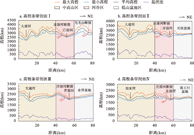
Since the late Cenozoic, the northeast extension of the Tibetan Plateau has resulted in a strong tectonic uplift in the Qilian Mountains, which formed a complex tectonic pattern and a rapidly changing tectonic landform in the Qilian Mountains. The geomorphological features of the typical river basins reveal the neotectonic activity and geomorphological evolution in the region. The Zhuanglang River basin is located in the eastern segment of Qilian Mountains. As the front area of the northeast expansion of the Tibetan Plateau, the geomorphic parameters of the Zhuanglang River basin are very sensitive to tectonic activities. Extraction of geomorphic information in the Zhuanglang River Basin is helpful to reveal the response of geomorphic to tectonic activity, and to systematically discuss the geomorphic development characteristics and its tectonic significance in the area. There are Zhuanglang River fault, south Tianzhu Basin fault, Gedagou concealed fault and Jinqiang river-Maomaoshan-Laohushan fault in the basin and its margins. Since the late Cenozoic, these faults have been active and control the tectonic deformation, mountain uplift and river drainage geomorphology development in the basin. Based on ALOS DEM 12.5-m data and ArcGIS spatial analysis tool, this study conducted a preliminary analysis on the geomorphic characteristics of Zhuanglang River basin through elevation strip section, river slope index system (K, SL, SL/K) and Hack section, area-elevation integral value (HI) and integral curve (HC). The results show that the topographic relief in the Zhuanglang River area decreases from NW to SE, and the tectonic activity has the rule of east-west differentiation. The K, SL, SL/K and HI values in the west are higher than those in the east, and the up convexity in the west of Hack profile is more obvious than that in the east. The west side of HC curve is mostly convex or S-shaped, and the mutation of SL is mainly controlled by fault tectonic activities. The uplift rate of the west side of the basin is higher than the erosion rate, and the geomorphic evolution is in the early or mature stage. The Zhuanglang River fault still has tectonic activity since the late Cenozoic, and the drainage pattern of the Zhuanglang River area is controlled by reverse wash slip.
Key words: Zhuanglang River fault; tectonic geomorphology; DEM; geomorphic indices
CAO Pengju , LIU Xiaobo , CHENG Sanyou , XIAO Liang , WANG Xi . Geomorphic feature of the Zhuanglang River Basin in the eastern margin of Qilian Mountains and its tectonic implications[J]. GEOGRAPHICAL RESEARCH, 2023 , 42(1) : 262 -279 . DOI: 10.11821/dlyj020220345
表1 庄浪河流域31条次级河流主要地貌参数Tab. 1 Parameters list of the 31 rivers of the piedmont drainage in the middle segment of the Zhuanglang River Drainage Basin |
| 河流编号 | 河流长度L(km) | 流域面积A(km2) | K | SL | SL/K | HI |
|---|---|---|---|---|---|---|
| R1 | 4.21 | 34.52 | 72.25 | 50.76 | 0.69 | 0.40 |
| R2 | 10.70 | 77.38 | 276.17 | 175.68 | 0.68 | 0.37 |
| R3 | 10.16 | 36.23 | 168.08 | 115.67 | 0.60 | 0.32 |
| R4 | 9.82 | 40.21 | 143.96 | 104.33 | 0.79 | 0.28 |
| R5 | 7.60 | 33.75 | 132.27 | 93.58 | 0.71 | 0.32 |
| R6 | 13.45 | 77.28 | 353.64 | 25.02 | 0.07 | 0.38 |
| R7 | 26.58 | 307.83 | 613.62 | 425.39 | 0.71 | 0.39 |
| R8 | 14.65 | 102.37 | 195.88 | 88.11 | 0.45 | 0.39 |
| R9 | 19.37 | 190.08 | 263.22 | 231.23 | 0.88 | 0.39 |
| R10 | 9.64 | 45.39 | 175.77 | 123.35 | 0.70 | 0.50 |
| R11 | 15.65 | 46.31 | 195.88 | 179.80 | 0.81 | 0.51 |
| R12 | 16.59 | 89.64 | 164.99 | 144.47 | 0.88 | 0.51 |
| R13 | 12.04 | 100.20 | 86.83 | 68.09 | 0.78 | 0.50 |
| R14 | 7.39 | 45.79 | 32.41 | 102.06 | 3.15 | 0.40 |
| R15 | 17.58 | 56.05 | 59.44 | 106.60 | 1.79 | 0.45 |
| R16 | 21.23 | 247.21 | 126.42 | 107.37 | 0.85 | 0.44 |
| R17 | 12.83 | 84.78 | 120.95 | 72.35 | 0.60 | 0.29 |
| R18 | 22.97 | 107.05 | 187.19 | 123.49 | 0.66 | 0.31 |
| R19 | 21.55 | 43.34 | 347.40 | 144.47 | 0.88 | 0.41 |
| R20 | 17.22 | 37.15 | 299.78 | 154.98 | 0.52 | 0.48 |
| R21 | 19.38 | 52.15 | 330.87 | 254.85 | 2.28 | 0.53 |
| R22 | 27.33 | 388.92 | 198.17 | 24.93 | 0.13 | 0.31 |
| R23 | 15.07 | 102.61 | 181.32 | 130.63 | 0.72 | 0.43 |
| R24 | 12.40 | 68.27 | 126.42 | 136.81 | 1.08 | 0.30 |
| R25 | 5.59 | 55.10 | 112.35 | 72.08 | 0.65 | 0.34 |
| R26 | 8.17 | 37.46 | 144.29 | 108.46 | 0.75 | 0.36 |
| R27 | 7.19 | 26.13 | 131.51 | 81.53 | 0.62 | 0.30 |
| R28 | 14.25 | 35.33 | 304.35 | 150.42 | 0.49 | 0.36 |
| R29 | 7.72 | 34.01 | 165.20 | 118.04 | 0.71 | 0.29 |
| R30 | 12.21 | 49.59 | 312.46 | 105.02 | 0.34 | 0.35 |
| R31 | 8.27 | 35.86 | 154.56 | 123.63 | 0.80 | 0.49 |
图5 庄浪河流域K、SL、SL/K空间分布图及庄浪河流域地质简图Fig. 5 Spatial distribution of K, SL, SL/K in the Zhuanglang River Drainage Basin and geological sketchof the Zhuanglang River Drainage Basin |
图6 干流西侧支流及干流的标准河流坡降SL/K和Hack剖面Fig. 6 SL/K and Hack profiles of standard river slopes on the west side of the main stream |
真诚感谢两位匿名审稿专家在论文评审中所付出的时间和精力,专家对定量地貌研究方法的运用和地貌证据分析方面的建议对文章质量提升有很大帮助。
| [1] |
|
| [2] |
|
| [3] |
|
| [4] |
|
| [5] |
|
| [6] |
|
| [7] |
方小敏, 赵志军, 李吉均, 等. 祁连山北缘老君庙背斜晚新生代磁性地层与高原北部隆升. 中国科学: 地球科学, 2004, 34(2): 97-106.
[
|
| [8] |
|
| [9] |
|
| [10] |
高效东, 谢虹, 袁道阳, 等. 祁连山东段石羊河流域河流纵剖面及其构造意义. 地震地质. 2019, 41(2): 320-340.
[
|
| [11] |
刘静, 张金玉, 葛玉魁, 等. 构造地貌学: 构造-气候-地表过程相互作用的交叉研究. 科学通报, 2018, 63(30): 3070-3088.
[
|
| [12] |
金德生, 乔云峰, 杨丽虎, 等. 新构造运动对冲积河流影响研究的回顾与展望. 地理研究, 2015, 34(3): 437-454.
[
|
| [13] |
袁道阳, 刘百篪, 张培震, 等. 兰州庄浪河断裂带的新构造变形与地震活动. 地震学报. 2002, 24(4): 441-444.
[
|
| [14] |
张福样. 祁连山庄浪河地貌发育的若干特征. 浙江大学学报, 1986, 20(2): 101-109.
[
|
| [15] |
张福样. 根据古浪幅及邻区卫星影像讨论祁连山庄浪河的河流袭夺问题. 遥感学报, 1987, 2(4): 302-309+326.
[
|
| [16] |
候康明, 袁道阳, 李绍业. 武威-天祝-庄浪河NNW向断裂分段及变形特征. 地壳形变与地震, 1999, 19(3):55-63.
[
|
| [17] |
周德敏, 甘卫军, 任金卫, 等. 基于GPS观测资料反演庄浪河断裂带、马衔山北缘断裂带的滑动速率. 地震地质, 2005, 27(4): 706-714.
[
|
| [18] |
周德敏, 张效亮, 梁诗明, 等. 马衔山北缘断裂带及庄浪河断裂带的地震危险性分析. 地震研究, 2014, 37(1): 53-60.
[
|
| [19] |
袁道阳. 青藏高原东北缘晚新生代以来的构造变形特征与时空演化. 北京: 中国地震局地质研究所博士学位论文, 2003: 94-95.
[
|
| [20] |
刘小凤, 袁道阳, 刘百篪. 兰州及邻近地区河流阶地变形特征. 西北地震学报, 2003, 25(2): 121-124+142.
[
|
| [21] |
刘兴旺, 袁道阳. 兰州庄浪河阶地差分GPS测量与构造变形分析. 西北地震学报, 2012, 34(4): 393-397, 404.
[
|
| [22] |
|
| [23] |
|
| [24] |
|
| [25] |
|
| [26] |
张会平, 杨农, 张岳桥, 等. 岷江水系流域地貌特征及其构造指示意义. 第四纪研究, 2006, 26(1): 126-135.
[
|
| [27] |
吴晓. 庄浪河流域各乡镇降水蒸发情况分析研究. 甘肃水利水电技术, 2019, 55(6): 13-17.
[
|
| [28] |
姚志春, 王得虎, 刘佳莉, 等. 甘肃省庄浪河流域水资源可持续利用对策研究. 水资源与水工程学报, 2010, 21(6):109-112+116.
[
|
| [29] |
张琳. 甘肃省天祝县降水量时空特征分析. 甘肃水利水电技术, 2021, 57(6): 13-15.
[
|
| [30] |
徐文. 庄浪河流域水资源评价及水资源承载能力研究. 兰州: 兰州大学硕士学位论文, 2019: 13-17.
[
|
| [31] |
蔡庆空, 蒋金豹, 张玲, 等. ALOS-PRISM立体像对提取DEM的应用研究. 测绘科学, 2014, 39(1): 70-73.
[
|
| [32] |
周朝. 北天山独山子背斜时空演化的地质地貌约束. 北京: 中国地震局地质研究所硕士学位论文, 2020: 38-39.
[
|
| [33] |
|
| [34] |
曹凯, 王国灿, 王岸. 东昆仑山昆仑河纵剖面形貌分析及构造涵义. 地球科学(中国地质大学学报), 2007, 32(5): 713-721.
[
|
| [35] |
赵洪壮, 李有利, 杨景春. 北天山流域河长坡降指标与Hack剖面的新构造意义. 北京大学学报(自然科学版), 2010, 46(2): 237-244.
[
|
| [36] |
赵国华, 李勇, 颜照坤, 等. 龙门山中段山前河流Hack剖面和面积-高程积分的构造地貌研究. 第四纪研究, 2014, 34(2): 302-311.
[
|
| [37] |
|
| [38] |
|
| [39] |
苏琦, 袁道阳, 谢虹, 等. 祁连山西段疏勒河流域地貌特征及其构造意义. 地震地质, 2016, 38(2): 240-258.
[
|
| [40] |
李玉辉, 丁智强, 吴晓月. 基于Strahler面积-高程分析的云南石林县域喀斯特地貌演化的量化研究. 地理学报, 2018, 73(5): 973-985.
[
|
| [41] |
武登云, 张天琪, 程璐, 等. 地貌形态指标揭示的北天山乌鲁木齐河流域新构造活动特征. 第四纪研究, 2018, 38(1): 193-203.
[
|
| [42] |
洪艳, 赵银兵, 王运生, 等. 利用面积高程积分方法研究龙门山断裂带地貌隆升特征. 科学技术与工程, 2019, 19(30): 43-51.
[
|
| [43] |
常直杨, 王建, 白世彪, 等. 均值变点分析法在最佳集水面积阈值确定中的应用. 南京师大学报(自然科学版), 2014, 37(1): 147-150.
[
|
| [44] |
李吉均, 方小敏, 潘保田, 等. 新生代晚期青藏高原强烈隆起及其对周边环境的影响. 第四纪研究, 2001, 21(5): 381-391.
[
|
| [45] |
李吉均, 方小敏, 马海洲, 等. 晚新生代黄河上游地貌演化与青藏高原隆起. 中国科学(地球科学), 1996, 26(4): 316-322.
[
|
| [46] |
何文贵, 刘百篪, 吕太乙, 等. 天祝盆地边缘断层的全新世活动及盆地的演化与形成. 西北地震学报, 1996, 18(1): 61-66.
[
|
| [47] |
郑光佑. 台湾西部山麓带前缘流域面积高程积分之构造意义研究. 台南: 高雄师范大学硕士学位论文, 2002: 1-83.
[
|
| [48] |
袁道阳, 刘小凤, 郑文俊, 等. 兰州地区活动构造格架与变形特征. 地质学报, 2004, 78(5): 626-632.
[
|
/
| 〈 |
|
〉 |