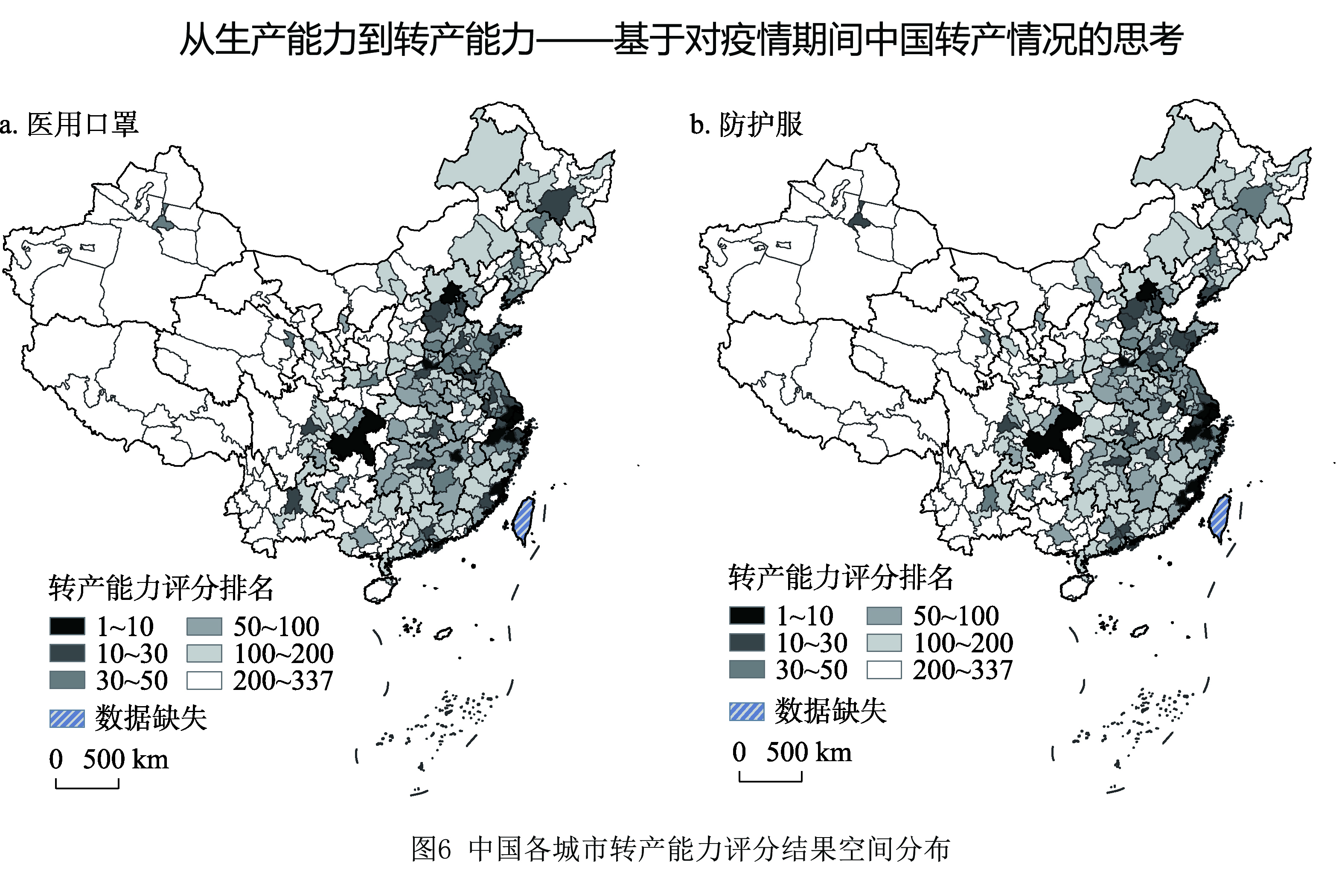
The distribution of China's productivity has focused on production capability and neglected the capacity of production conversion for a long time. Since the outbreak of COVID-19 worldwide in 2020, many cities in China have effectively alleviated the shortage of epidemic prevention materials by production conversion. This makes the urban capacity of production conversion begin to attract attention. This paper discusses the role of industrial relatedness of evolutionary economic geography in urban capacity of production conversion and builds the index system of China's urban capacity of production conversation by using the data of the registration certificate of domestic medical devices on the official website of National Medical Products Administration, Chinese Customs Trade Statistics, Chinese Industrial Enterprises Database, and other statistical data. The results of the study found that: (1) Based on the analysis of actual production conversion of epidemic prevention materials in the first quarter of 2020 in cities of China, the relatedness density can better represent the capacity of production conversion of the city. (2) The index system of China's urban capacity of production conversion with industrial relatedness as the core index can further optimize the evaluation of the urban capacity of production conversion, which provides a scientific reference for how to take both productivity and capacity of production conversion into account at the same time in China's future productivity distribution.
This paper predicts China's economic growth rate in 2020 under the influence of the COVID-19. We measure the impact of the COVID-19 on China's regional economic distribution quantitatively. This paper predicts China's economic growth in 2020 from three scenarios: pessimistic, moderate, and optimistic. According to the severity of the epidemic in various regions, the historical data is used to predict the economic data of each province in 2020. Then, the Dagum Gini method is used to analyze the changes of China's regional economic structure after the epidemic. Even in the pessimistic scenario, China's economy can still achieve 1.90% growth in 2020, and is fully capable of achieving the “six stability” and "six guarantees" tasks to ensure the stable and healthy operation of the economy and society; under the moderate and optimistic scenarios, it is expected that China's economic growth rate in 2020 will reach 2.20% and 3.74%, respectively. The analysis of regional differences shows that the trend of regional differences is expanding, the imbalance within the region is intensified, and the differences between regions become larger. This paper is helpful to objectively and comprehensively understand the changes of regional economic after COVID-19, and provide policy recommendation for the optimization and adjustment of regional economic policies.
Taking China and four Indo-China Peninsula countries as research objects, this paper uses the methods of multi-factors comprehensive evaluation, IRIO input-output modeling, comparative advantage index (RCA) and global value chain (GVC) analysis to quantitatively evaluate the spatial and timing situation of regional GVC competitive. It depicts the global industrial transfer characteristics of 43 economies and 8 main industrial types since the beginning of the 21st century, as well as measures the regional evolution trends of industrial transfer-in attraction and global manufacturing competitiveness, and also it analyses the GVC participation and position of different economies and industrial sectors from the perspective of GVC. The conclusions are as follows: (1) In 2000-2014, China became the economy which undertook the largest scale of global industrial transfer-in, and regional resource and comparative advantages originated from different economies were the main factors which attracted global industrial transfer-in most. (2) From 2000 to 2018, China's attractiveness of global industrial transfer-in remained at a high level, which was much higher than the four Indo-China Peninsula countries, but the attractiveness of global industrial transfer-in of China showed a trend of decline due to the increase of production cost in recent years. (3) In 2005-2015, the competitive advantages in middle-level and high-level manufacturing of China had been strengthened continuously all over the world, and Cambodia and Vietnam had respectively enhanced their global competitiveness in primary manufacturing and low-level manufacturing during the same period. (4) China's overall level of GVC participation was lower than Vietnam in 2005-2015, but its GVC position index was far ahead of the four Indo-China Peninsula countries, which indicated that China's leadership and control force in region GVC was dominant.

Since the 1980s, there has been an unprecedented upsurge in researching world cities. The existing literature of world cities has investigated the role of advanced producer services by largely focusing on the experiences of post-industrial countries, however, little has been done in interrogating manufacturing industry. They found that the relationship between manufacturing industry and producer services is loosen, but some disagreed. This research is underpinned by field studies and in-depth interviews by focusing on Honda in Guangzhou and Airbus in Hamburg. In doing so, this research aims to analyze the industrial relationship with the process of territorial embeddedness of industry into the local producer service firms. This research has two research findings: (1) the territorial embeddedness has experienced three stages and three modes, which are headquarter-driven embeddedness, customer-following embeddedness, and local purchasing embeddedness. (2) The influencing factors of territorial embeddedness including cost and the scale of market, enterprise strategy and culture, service level of local enterprises, economic environment and infrastructure. This research addresses the gap of weakening industrial relationship and different paths of development in world cities by further destabilizing the hegemony of Anglo-American studies. It provides a fresh view from the micro-level by revealing the dynamic industrial relationships between manufacturing and local producer services in world cities.
Since the financial crisis, the world economy has emerged as geo-economy and showed network features. To expand and deepen the research paradigm of geo-economic system, a systematic and dynamic perspective is needed to explore its intrinsic properties and the operating law. Considering the importance of the commodity trade in measuring geo-economic system, this perspective provides an effective path to study the geo-economic system. In this paper, we constructed an analytical framework of geo-economic system on the basis of System Dynamics to examine the evolutionary properties, functional levels and types of the global geo-economic system from 1996 to 2016 from the perspective of global commodity trade network. The result shows that, firstly, in terms of the attribute features, geo-economic system has the small world property. Its evolution is conjugated with the development of the world economy. The scale-free property of degree gradually disappears, and the construction of geo-economic relations is balanced. The scale-free property of weighted degree is significant, and the increase in the number of intermediate-order countries optimizes the weight-degree fractal structure. Geo-economic system belongs to the mismatch network. Geo-economic links follow the selection mechanism and tends to weaken. Secondly, in terms of the functional level, geo-economic system presents a strong relationship-dependent effect and the third-party effect. The association between the weighted degree centrality and eigenvector centrality is the highest and displays a spatial match, both of which gradually form a spatial pattern of East-West parallelism with China and the US acting as two cores. The betweenness centrality and the closeness centrality show spatial homogenization. The quantity distribution of its function type presents a “pyramid” structure, indicating the power of countries in the world economy, while spatially three core-periphery clusters show a “circle” structure. The competitiveness of the central geo-economic zone increased. The network structure of the transformation geo-economic zone is diverse and complicated. The function level of some countries in the general geo-economic zone leaped, while the isolated geo-economic zone remains stable. Natural geospatial separation, national socio-economic development, the interaction and coupling among functional zones are important factors driving the spatial evolution of geo-economic functional zones.
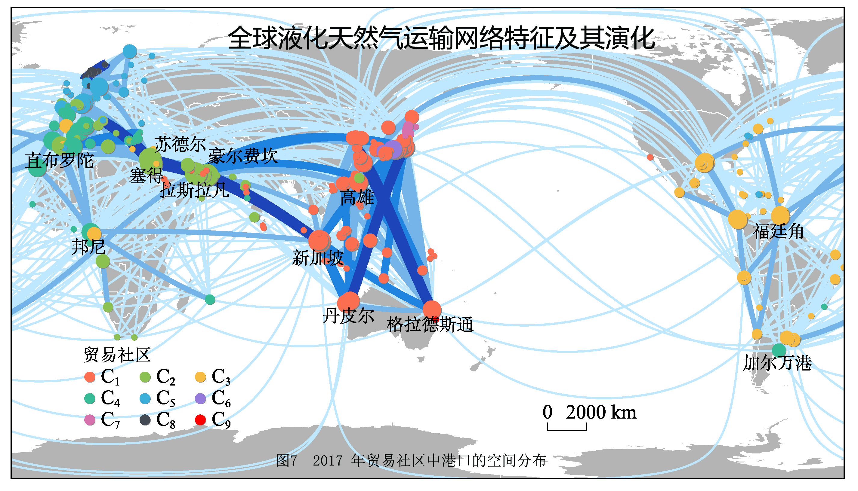
As a clean, low-carbon energy source, liquefied natural gas (LNG) plays an increasingly important role in the global energy consumption market. LNG is transported between ports through vessels, but current studies on LNG trade patterns and their evolution at the port scale is relatively limited. In this paper, we use complex network indices and community detection methods to analyze the trade pattern and evolution of the global LNG transportation network using vessel trajectory from 2013 to 2017. The results show that: (1) The LNG transportation network scale presents phased changes characteristics, and the trade relations between ports in the network are relatively sparse; (2) LNG transportation network forms a series of trading communities around hub ports. Among them, Singapore, Ras Laffan and Khawr Fakkan play extremely important roles; (3) Both ports in the same community and the communities of ports within the same country show a more geographically concentrated character.
In China, High-Tech Industrial Development Zones (HTIDZs) are industrial spatial agglomerations acting as the contributors to technological change and economic development. However, some current major issues, e.g. ‘enterprises’, the practical actors underpinning knowledge absorption and production of HTIDZs, are rarely discussed in previous literature. From the perspective of enterprises, lack of research is therefore leading to the inadequate cognition to the heterogeneity of knowledge bases and their effects on innovation. In this study, the listed enterprises located in state-level HTIDZs are utilized as microcosmic subjects. By implementing a cluster analysis based on data sets of the above-mentioned enterprises, we come up with a typology of knowledge bases, which may enable the classification of enterprise knowledge bases and presentations of HTIDZ knowledge base attributes. In order to further explore the effects of knowledge base attributes on innovation competitiveness, a multiple linear regression model is established for demonstration of the relatedness between knowledge base attributes and Commodity Sales Income of HTIDZs. Correspondingly, two geographically weighted regression models are constructed and applied when Technical Income and Product Sales Income are respectively taken as dependent variables. The results indicate that: (1) “efficient” knowledge base, distinct from “analytical” knowledge base, “synthetic” knowledge base and “symbolic” knowledge base that have been highlighted in previous literature, is identified and defined based on the cluster analysis of enterprises. (2) For HTIDZ, proportional equalization of knowledge bases inhibits the increase of Technology Income, and from the south to the north, the intensity of such inhibiting effect is strengthened. Specialization of analytical knowledge base has motivating effect for the increase of Technology Income while only a few HTIDZs are under discussion. (3) For HTIDZ, proportional equalization of knowledge bases is an effective way to increase Product Sales Income. It is illustrated that such influence tends to be gradually enhanced from the middle to the north and the south. The relative concentration of symbolic knowledge base goes against the improvement of product competitiveness, especially in southern China. (4) For those HTIDZs whose enterprise quantities outnumber a certain threshold, the promotion of specialization of symbolic knowledge base contributes to the growth of Commodity Sales Income. Policy making which aims to foster innovation capabilities of HTIDZs may benefit from this research under the view of “enterprises-knowledge”.
The inconsistency between a company's headquarters and its registered location not only violates Chinese laws, but also has a series of negative effects on the company itself and the government. However, the spatial separation of the company's headquarters from its registered place is very common in China, but this phenomenon and its effects have not received the attention of scholars. Therefore, based on the data provided by Wind Financial Terminal, this paper studies the pattern of the cross-city separation of the headquarters and registered place of China's A-share listed companies, and examines the formation process of the cross-city separation by tracking the company's annual report, and finally analyzes the impact of different indicators on the cross-city separation of headquarters and registered sites by using the binary Logistic regression model. The results show that: (1) as of July 13, 2018, 31.45 percent of listed companies with headquarters and registrations were found in different cities, of which, 177 in different provinces and 105 in different cities in the province. In addition, there are 21 listed companies with two headquarters, and at least one headquarters is not in the same city as the place of registration. (2) For listed companies with headquarters and registration signed up in different provinces, their headquarters are generally concentrated in economically developed provinces and cities, especially in Beijing and Shanghai. For companies with headquarters and registered cities separated in the province, their headquarters are mainly located in provincial capitals and cities specifically designated in the state plan. In contrast, the distribution of registration sites in both types of companies is more dispersed and registration sites are mainly in ordinary cities. (3) Inconsistencies between headquarters and registrants in cross-city migration are the main reasons for their separation between cities. The frequency of headquarters migrations is much greater than that of registrations. Headquarters are usually moved to higher-level cities such as Beijing and Shanghai, or provincial capitals, and the migration is concentrated. In contrast, the place of registration generally moves into the ordinary city, and the migration has a certain degree of diffusion. (4) The age of the listed company has no impact on the separation of the address of the listed company. The industry, organization form, registration city night light intensity, ST and whether to reorganize have an impact on the separation of listed companies' addresses across cities, but the influences in intra-provincial separation and inter-provincial separation are quite different.
The multi-level perspective city network is of great significance in understanding spatial interaction and linkages. Based on inter-city startup investments data, this study offers a new perspective to identify the spatial structure of China's city networks from node- to linkage-level, and further explore the organization patterns from sub-network-level. This study can deepen the understanding of city network structure under the effects of city hierarchy and distance decay. The results are shown as follows. At the node-level, the distribution of startup investments is uneven and highly concentrated in megacities and municipalities. Moreover, the rank-size distribution of startup investments tends to be more monocentric than that of population and GDP. At the linkage-level, first, the city network based on startup investments has an obvious hierarchical structure, and the connections between Beijing, Shanghai and Shenzhen are the strongest and form a triangular framework. Second, inter-city startup investments are mainly flowing within the same industry, and the service industry owns the most outflows and inflows. Third, inter-city startup investments display distance decay, but high-hierarchy cities can break the distance constraint. For example, the linkages are close between the three urban agglomerations with Beijing, Shanghai and Shenzhen as the cores. At the sub-network-level, seven communities are identified through community analysis, and we suggest that the community boundaries have two spatial characteristics including administrative district economy and the spillovers from high-hierarchy cities. Additionally, the organization patterns of communities are various, including single-core; single-core and multi-pairs; double-core and multi-pairs; and multi-core patterns. Compared with the existing research for other perspectives of city network, there are two new findings in our study.
Based on methods of extended intensity index, equal sector analysis method, kernel density analysis and spatial syntax, with the assistance of enterprise geographic data of the cultural industries, as well as the nighttime light data and the axis model of the urban road network in the years of 1998, 2008 and 2018, we analyzed the characteristics of spatial growth of cultural industries in Xi'an's core districts and the evolution of urban spatial morphology, and explored their spatial relationship and the corresponding mechanism. The results show that: (1) The cultural industries in Xi'an's core districts expanded along northeast to southwest, gradually evolving from single core or one belt and two cores into one axis, one belt and two cores in terms of spatial agglomeration pattern. (2) The urban external spatial morphology of the core districts expanded along northeast to southwest, and the internal spatial morphology evolves from lump-shaped single core or strip-shaped primary-secondary cores to lump and strip shaped double cores. (3) There is a significant correlation between the growth of the cultural industries in the core districts and the evolution of urban spatial morphology in different periods. That is to say, and the evolution of their spatial form patterns is highly coupled. (4) The pioneering development mode of the cultural industries in the core districts promotes the expansion of the urban external spatial form. The complementary development mode, including the spatial expansion in urban built-up area and continuously closing-up to the existing industrial agglomeration, facilitates the optimization of the urban internal spatial morphology. The study is of great significance for perfecting the spatial research system of cultural industry and promoting the coordination in which industrial space supports urban spatial transformation.
Under the wave of urbanization and modernization, the transformation in space has been a phenomenon of great concern to the academic community. In the process of economic development and spatial evolution of urban historic districts, the introduction of cultural and creative industries has provided a new way for urban renewal and spatial transformation. In addition, research confirmed the role of cultural and creative parks in urban economic development. Therefore, the Chinese government is holding an increasing positive attitude to cultural and creative industries, and local governments have issued corresponding policies to encourage the establishment of cultural and creative parks according to local conditions. The paper uses system dynamics mechanism to construct causal circulation diagrams and analyzes the spatial reproduction process of Beishan community in Zhuhai based on the qualitative material. Consequently, the paper reveals that the dynamics mechanism of Beishan's spatial production consists of five positive feedback loops and one negative feedback loop. Based on this study, recommendations for historic district and the construction of new urbanization are provided. Results indicate that: (1) the government's planning and renovation of backward urban villages and the transfer of residents' space are the beginning of Beishan's spatial reproduction; (2) the entry of cultural entrepreneurs has created new spatial subjects and social relations, renewed and reused the space of historical buildings, and created new cultural and creative space; (3) the diversified tourist perception and media dissemination have reproduced the image of Beishan; (4) the diversification of spatial subjects has built a space in which multiple attributes of Beishan are intermingled, complex and stable, and each interest subject has reached relative balance in the game with compromise. On the basis of loop analysis, the study combines the theory of “triple cycle of capital” and system dynamics model to explore the spatial reproduction mechanism of Beishan community. This study provides a new tool with system foresight for the development and transformation mechanism of the historical district, and provides reference for the development and construction of the new urbanization.
The second home sojourn has emerged in the grey zone between short-term tourism and permanent tourism immigration, which is a new phenomenon of population flow described as “lifestyle migration”, “seasonal lifestyle tourism” or “residential tourism”. The second home sojourn, which has become popular across the Western world and in the developing countries such as China, is a response to the desire of people for leisure, health and a more comfortable lifestyle. With the rise and the shift of study on “everyday life” in geography academia, the daily life and social interaction have become an important research field in tourism geography studies. Geography has shifted its interest on daily life from grand structural narration to diversification and microcosm. Relevant literature concerning the development of second home sojourn and the social interaction is reviewed, and striking differences are found to exist between second home sojourners and local residents, which are reckoned to be the primary factors affecting the social interaction between each other. However, no current research has deepened our understanding of how such differences are constructed. There is limited understanding of how these cultural and social differences shape the way they act in relation to each other. Therefore, a case study of Sanya city is carried out, targeting at exploring the roots of non-internal differences between the second home residents and the local residents, and the micro-processes of these differences on social interaction, starting from the subjective initiative of “human” within the symbolic interaction theory framework. It is discovered that there exists a notable opposition between “Sanya people” and “Northeastern people”, due to the differences in identity symbols, and cultural and geographic environment between travelers (“outsiders”) and residents (“locals”). However, these differences are endowed with new connotations through the definitions and interpretations of “human”, thus affecting the social interaction between them. The detailed processes include three phases: the knowledge of others, the evaluation of others and the willingness to interact with others. It is concluded that both second home sojourners and local residents tend to know little of others, form negative judgments on others, and have little willingness to interact with others. The research on the internal operation mechanisms of social interaction at the micro level is supposed to improve the effectiveness and pertinence of macro policy-making and promote the sustainable development of second home sojourn destinations.
It has been a trend for the study of urban functional areas to employ multi-source at a finer tempo and/or spatial scale to contribute a niche understanding of the structure and content of the area. Drawing on advancement of technological development of new type and new sources of geo-coded data, the paper proposes a set of indicators to understand urban functional areas, including the intensity of the use of the area, the difference in the use between day and night, and the degree of multifunctionality. The empirical research is taken in Beijing and these indicators are derived by integrating the mobile phone signaling data of 14400 grid areas in the urban area in 2017 and 380975 points of interest (POI) data from Gaode map in 2016. The main research conclusions are as follows. (1) Every standard area in this paper has a square of 250 m×250 m. The number of Beijing's daytime active areas is three times that of nighttime active areas. The nighttime use intensity of restaurant, living, and other service facilities is higher, and the daytime use intensity of financial, tourism, and public service facilities is higher. (2) Tourism (28.2%), residence (12.1%), transportation (11.4%) are the three types of functional areas with the largest proportion of Beijing area, and the smallest area proportion is financial function district (2.8%), showing that the spatial characteristics of tourism, finance, and public functional areas gather, and other functional areas' distribution presents scattered characteristics. (3) Residential, restaurants, living, and other functional services are strongly dependent on each other, while tourism and enterprise functional services show strong exclusivity to other functional types. Except for the tourism functional areas, there appears an obviously different functional mixing pattern in the central urban area of Beijing. In this paper, the area with the highest function mixing degree (greater than 0.98) is defined as the highly mixed functional area, which accounted for 24.6% of the study area. The result of the functional area divisions has a strong practical significance for Beijing urban planning, and also provides an effective method and a richer perspective for the future in-depth study of urban functional areas.
By integrating the content of social identity and place, this paper puts forward the concept of regional social identity. Both social identity and place are crucial concepts in the field of social sciences and geography. Scholars have achieved massive research results on social identity in psychology, politics, sociology and other disciplines. Research in place also plays an important role in human geography. However, the previous studies lack the deep thinking of spatial attributes and the cognitive improvement of the place. Place is a kind of social orientation of human beings in the social and cultural structure, representing the sense of belonging and dwelling. From the proposal of the new urbanization to the transformation of the main social contradictions, regional research is faced with the transformation from “looking for the factors of regional development increment” to “analyzing the factors of regional differentiation stock”. The regional research in the new era needs to change from the “space efficiency-oriented” research led by industrialization or urban land expansion to the “space equity/justice-oriented” research, so the research on the adaptability of objective economic development and subjective social cognition needs to be carried out urgently. This study analyzes the spatial differentiation of regional social identity based on spatial heterogeneity by the geographical detector and attempts to explore the key geographical detection factors of spatial differentiation through the macro level natural-attribute factors, built-environment factors and socio-economic environmental factors. We hope to find out the key geographical detection factors that cause the spatial differentiation of regional social identity to popularize regional social identity in academia. It is found that along with the rapid development of China's economy and society, the key factors that affect the regional social identity begin to shift from the regional geographic environment macro level factors to the built-environmental factors and socio-economic environmental factors. At the sub-factor level, the per capita GDP, unmarried ratio, the average number of family houses and other geographical detector sub-factors have great influences on the spatial differentiation of regional social identity.
In the last 40 years, China has experienced large-scale migration, which has greatly contributed to its urban construction and economic growth. Meanwhile, migrants face residence and employment instability in the process of urban renewal. The existing literature mostly attributes this instability to individual factors, but ignores the influence of macro events (such as urban demolition and reconstruction) or the industrial restructuring on migrants' lives. Moreover, in most studies, migrants' residence and employment changes are regarded as independent behaviors of non-interference rather than as correlated behaviors. To fill these research gaps, this study builds a theoretical framework for the coordinative changes of migrant residences and employment. Based on a large-scale survey in Beijing in 2013, we use multilevel bivariate probit models to analyze how the background features impact migrants' residence and employment changes under urban renewal. In particular, this research focuses on two types of background features: the instability of residence, which is measured by the number of city villages in the sub-district, and the instability of employment, which is measured by the proportional area of the wholesale and retail industries in the sub-district. Moreover, we analyze the coordinative change between migrants' residences and employment. The results show that: (1) Compared with residents, migrants are more likely to change residence and employment, and the instability of their residence and employment are correlated more with urban renewal. Migrants living in the city center have higher stability in their residences and employment than those in outlying areas. (2) At the sub-district level, the difference in probability of employment change is significantly greater than that of residence changes. Residence and employment changes are correlated, and change in residence (or employment) is likely to lead to changes in employment (or residence) simultaneously. (3) Migrants living in the sub-districts of city villages have tended to report a higher probability of residence change in the last five years. (4) The young-generation migrants have higher coordination of residence-employment change than old-generation migrants, and the residence instability of the young generation is more related to the instability of the living environment in the sub-districts.
Existing criminal geographical research mainly relies on cluster-based methods and aggregated data according to pre-defined geographic limits, which not only causes modifiable areal unit problem, but also restricts the development of classical criminal geography theory. Consequently, this paper pioneered the use of DO index, a new distance-based method, to Chinese criminal geographical research, in order to reveal the spatial distribution relationship between theft, robbery, violent crime and 32 main urban functions in continuous space of Beijing from 2013 to 2018. Firstly, the research demonstrated that even distribution of economic and social activities was controlled, 98% of the “crime-function” combinations were significantly colocalized. The traditional method judging merely on a single spatial scale would probably underestimate the number of types of crime generators. Secondly, most pairs of “crime-function” combinations inverted U-shaped relationships between the scale and degree of colocalization, because criminals were more likely to choose medium returns, risks, and costs in the medium spatial scale. This finding made up the spatial perspective blind spot of routine activity theory and rational choice theory. Thirdly, with improvement of supervision intensity, the degree of colocalization between crimes and all urban functions were gradually decreasing. Owing to obvious ways of committing crimes and higher capture probability, the colocalization spatial scale of violent crime was greater than that of theft or robbery. Fourthly, compared with single colocalization type in existing criminal pattern theory, there were many sub-types such as strong colocalization in large, medium, small spatial scales and weak colocalization, which showed the necessity of subdivisions of crime generators. All in all, nearly half of the “crime-function” combinations have always belonged to the same subgroup, which proves that the crime prevention and control work is evidence-based. Limited resources should be given priority to bus stations, arterial road junctions, foreign-related sites, high-end communities, and factories. Additionally, for the crime prevention work, it is important to formulate specific measures according to the type of crime generators, and break through traditional control concepts of fixed points and fixed jurisdictions. All in all, this study simplified the complex crime space formation mechanism into the geometric relationship between crime points and function points. It should be pointed out that the distance-based method was difficult to control the interference of confounding factors and needed to be addressed in future research.
The mechanism of water-food-ecosystem nexus in dryland under climate change and human activities is one of the frontier scientific issues in the study of Coupled Human-Earth System. The research output can provide scientific support for the comprehensive guarantee of ecological security and food security linked by water security in dryland. In this study, the research frontier of water-food-ecosystem nexus was sorted in the following four aspects. First, land use change is an important entry point on studying the spatio-temporal characteristics of water-food-ecosystem nexus in dryland. Second, the synergy-tradeoff of ecosystem services can be used to analyze the driving force of water-food-ecology nexus, while the current cases are mostly limited to the statistical description and have not obtained the mechanism. Third, social-hydrological system model is an important direction for the development of Coupled Human-Earth System model in dryland. Life cycle model and ecosystem service flow model are applied in recent studies. Fourth, water-food-ecosystem are still in the stage of exploring applicable ways of spatial planning, resource use control and resource use efficiency enhancement for local drylands. In the future research, it is necessary to promote the following three aspects, including the effects and responses of ecohydrological processes on agricultural production, the ecosystem services tradeoffs and their impact on human well-being, and the territorial development and protection under the optimization of water ecological security pattern, so as to build a bridge from science to decision-making in the research of water-food-ecosystem nexus.
Marine geopolitics focuses mainly on the relationships between the politics and marine geographical environment and are committed to shaping political and economic pattern of the world theoretically and practically. Starting with the interplay of human and ocean, this paper constructs an analytical framework for marine geopolitical thoughts evolution, discusses the elements of human-ocean relation and state-ocean interaction mechanism, and sorts out the evolution path, content composition and stage features of the marine geopolitical thoughts of China and the West. Human-ocean relation, the interplay between human activities and ocean, is composed of the main body of human activities, land and ocean. The state is one of the most important social-spatial organizational units for studying human-ocean relation, and it is also one of the main research objects in the marine geopolitics. National will and demand, national cultural genes, and technological change are the main factors for the state and the ocean relations. As human-ocean relation progresses, some stage features appear in both China and the Western countries, such as “from land to sea, using marine resources to support land”, “expanding from land to sea, and opening up sea routes”, “checking and balancing the land with the sea, the conflict between the sea and the land”, and “coordinating the land and the sea”. From the perspective of the evolution of the relation between the state and the ocean, Chinese and Western marine geopolitical thoughts have both commonalities and significant differences. On the one hand, with the similar trends developing and many thoughts in common, they have all specifically evolved against the historical background. On the other hand, some major differences in philosophical basis, thinking concepts, and cognitive horizons exist between Western countries and China’s marine geopolitical thoughts from different periods of time. “Realism” and “peace-cooperativism”, “conflict expansion” and “negative conservatism”, “global vision” and “Huaxia Center” formed a striking contrast in the evolution of Chinese and Western marine geopolitical thoughts. In the future, China should better understand the interrelationships between critical inheritance and transformation, gather together marine geopolitical thoughts under the background of marine shared community for mankind, and enrich Chinese marine geopolitical theoretical system.
With the further development of climate change research, China has accumulated and released more and more data on climate change, which provides valuable data sources for in-depth systematic scientific and technological innovation. Relevant data stocks are getting larger and larger, and storage types are becoming richer and richer, which has pushed us into an unprecedented era of big data. The era of big data is inseparable from the openness and sharing of data. In this paper we first summarized the current status of the five major categories of data sharing services: scientific data on climate change drivers, scientific data on climate change facts, scientific data on climate change impacts and adaptation, scientific data on future climate change forecasts, and economic and social data related to climate change. A systematic analysis of the characteristics of data quality and data applications was also carried out. On this basis, future development trends of China's climate change scientific data sharing services in the context of big data, such as service management, market oriented operations, commercial services, public services, data publishing, blockchain technology, artificial intelligence, data mining, and machines learning, dynamic data sharing based on model computing, etc. were prospected. Finally, we summarized the challenges faced by China's climate change scientific data sharing services in the era of big data.
The actor-network theory (ANT), originated from the sociology of science, has been widely used in many disciplines. In the field of geography, this theory tends to break through the long-standing dualism between global and local, nature and society, etc. Much of the theoretical work has been done to understand the complex and obscure connotation of ANT. For instance, representative human geography scholars like Jonathan Murdoch and Sarah Whatmore proposed to cancel many dualistic presuppositions in geography, thus rethinking the nature of geographical knowledge through ANT. However, the current empirical studies in Chinese academic world show the trends of oversimplification and misuse of this concept by reason of lacking a sufficient understanding of the relationship between ANT and human geography. Therefore, the paper aims to investigate the interaction between the actor-network theory and human geography. Specifically, it is found that there are overlaps and similarities in the aspect of temporal-spatial view by summarizing and comparing ANT and the related theories of human geography. More importantly, the principle of general symmetry links ANT with human geography, which makes us re-recognize the description methodology, the significance of nature and materiality, and the network in human geography. Nevertheless, the understanding of ANT is still controversial and has been critically discussed, ranging from the aspects of social interpretation and network interpretation, the legitimacy of traditional criticism and the authenticity and validity of human-nonhuman symmetry. To accommodate the neglected and insufficient description of the real world, some geographers bring in assemblage thinking, including concepts like desire, virtual and flux. In addition, as the profound impact of the case study of the scallop experiment on the understanding and application of ANT by human geographers, the article analyzes the latent translation logic contained in this case. Finally, the study points out key issues that need to be reflected in the application of actor-network theory in empirical research, and indicates the possible directions for further research from the perspectives of human and nature, scientific knowledge production and dissemination. In summary, this paper discusses the enlightenment of ANT to human geography, which provides more possibilities of dialogues between different studies based on ANT, enhancing the innovation and geographical knowledge spillovers.