
The study on the land development process in the border area between Shaanxi and Inner Mongolia
Received date: 2013-10-27
Request revised date: 2014-04-15
Online published: 2014-08-10
Copyright
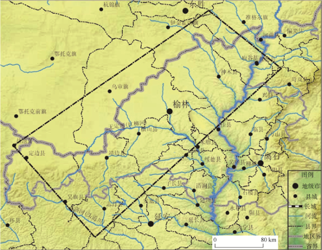
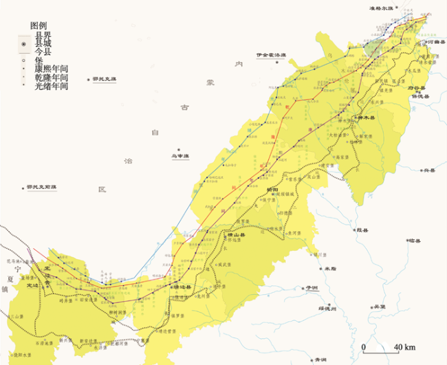
The border area between Shaanxi and Inner Mongolia is a typical transitional zone between the Mu Us Sandy Land and loess hilly region of northern Shaanxi province, which is the middle part of the transitionally ecological zone in North China and is also an agro-pastoral zone. This area has the sites of many Great Wall sections and castles that were built during different periods and the cultural landscape and natural landscape in this area are highly consistent. So it is a typical area for the study of the influence of human activity on the earth ecological system in different historical periods. In the early Qing Dynasty, this area set up "Jinliudi" to prevent the communication between the Han and Mongolian ethnic groups; Until the late period of the reign of Kangxi, the Hans were permitted to reclaime "Huopandi" in the Mongolia area, and then the government set up "Heijiedi" to restrict the Hans' activity of reclaiming north. However, the trend of private reclamation could not be stopped and in the late Qing Dynasty the policy of migrant reclamation proposed by Yi-Gu formed the pattern of the land use in the border area between Shaanxi and Inner Mongolia. So it is significant to make a research on the land use in this area, which reflected the interactive relation between the human being and the environment in the Qing Dynasty for more than 300 years. Overall, the land use at the junction area of Shaanxi and Inner Mongolia during the Qing Dynasty presented a "southern farmland and northern grassland" pattern. From the actual dividing line, this pattern is extremely stable. From the system boundary, the pattern is "relatively stable". Overall, the pattern experienced a process from establishment to gradual fuzzy and northward movement. The dividing line experienced a process where it moved northward gradually from "two sides" - "big edge" - Kangxi line - Qianlong line - Guangxu line, but it was still "relatively stable, "and" relatively clear". In the pattern and the development of agricultural production during the Qing Dynasty, there was always a "rational cultivation" selection, which was determined by the unique geographical environment and subject to the prevailing political and economic situation impacts. During a long period, government-led reclamation became the main part of reclamation in the Shaanxi and Inner Mongolia region. Political reasons, especially war, is an impor tant factor affecting reclamation in the Inner Mongolia region. In this process, the main body of reclamation of the government and the farmers, underwent a "rational choice" process. This process focused more on the political and economic factors rather than the ecological environment factor.
WU Chengzhong , DENG Hui , SHU Shiguang . The study on the land development process in the border area between Shaanxi and Inner Mongolia[J]. GEOGRAPHICAL RESEARCH, 2014 , 33(8) : 1579 -1592 . DOI: 10.11821/dlyj201408016
Fig. 1 Location of the study area图1 研究区位置图 |
Tab. 1 The collection situation of terrestrial and qualities of forage in Yulin in fifth year (1727) of Yongzheng表1 雍正五年(1727年)榆林府屯地及本色粮草征收情况[17] |
| 屯地 | 亩数(顷) | 实征银(两) | 本色粮(石) | 本色草(束) |
|---|---|---|---|---|
| 历年开垦地 | 182.54 | — | 300.89(该征) | 218 |
| 边墙外原报新增实熟地 | 3.3 | — | 7.9 | 10 |
| 原额糜地新开垦地 | 640.93 | 614.58 | ||
| 额外延绥等处养廉地 | 22.3 | 34.74 | ||
| 接收饶阳等处新开垦地 | 10.2 | 3.06 | 10.29 | |
| 总计 | 859.26 | |||
注:“边墙外原报新增实熟地”位于响水、波罗、清平、龙州、靖边各营堡,属于今横山 |
Tab. 2 The reclamation amount of terrestrial in Yanshui Town from the early Qing to the interim reign of Daoguang |
| 府州县 | 各项地亩 | 原额(顷) | 除荒并节年开垦(顷) | 实熟(顷) | 人丁 |
|---|---|---|---|---|---|
| 榆 林 府 | 府属原额共屯、糜余地 | 6999.81 | 298.77 | 1726.60 | 顺治十年225人;康熙元年至五十年间新收571人;又至乾隆三十六年编出105人 |
| 东路9城堡糜粮地 | 711.25 | 86.82 | 798.07 | ||
| 高家堡糜、屯地 | 59.95 | 略 | 15.82 | ||
| 中路城堡糜谷地 | 549.15 | 73.02 | 396.21 | ||
| 延镇养廉地 | 8.80 | 略 | 8.80 | ||
| 榆林城南及西门边塘 | — | 43.18 | 43.18 | ||
| 榆林卫沙草湾养廉地 | — | 2.20 | 2.20 | ||
| 总计 | 2990.97 | 实在364人 | |||
| 延 安 卫 | 原额屯糜地 | 41699.19 | 295.62 | 2555.79 | 顺治十年342人,康熙元年至五十年增351人,又至乾隆三十六年新增80人 |
| 安边堡养廉地 | 31.20 | — | 13.40 | ||
| 饶阳水堡 | — | 10.20 | 10.20 | ||
| 总计 | 2579.39 | 实在528人 | |||
| 葭州 | 建安葭州二堡 | 81.06 | — | 81.06 | |
| 绥德卫方连百户 | 78.70 | — | 24.60 | ||
| 总计 | 105.66 | ||||
| 绥 德 州 | 原额绥德卫腹里山坡下等地 | 1719.60 | 略 | 579.55 | 顺治十年有69人;后编新收98人,至乾隆三十六年新增42人 |
| 接收绥德卫 | 1535.90 | 略 | 518.03 | ||
| 总计 | 1097.57 | 实在123人 | |||
Tab. 3 The reclamation amount of terrestrial by county in Yanshui Town from the early Qing to the interim reign of Daoguang |
| 府州县 | 各项地亩 | 原额(顷) | 除荒并节年开垦(顷) | 实熟(顷) | 人丁 |
|---|---|---|---|---|---|
| 府谷 | 5堡城堡糜谷地 | 499.63 | 82.82 | 586.45 | |
| 神 木 | 神木堡4堡城堡糜谷地 | 130.56 | — | 184.76 | |
| 葭州转高家堡屯地 | 54.21 | — | |||
| 高家堡城堡糜地 | 50.96 | — | 15.82 | ||
| 总计 | 200.58 | ||||
| 榆 林 | 榆林县接收绥德卫 | 2710.80 | — | 864.84 | 顺治十年153人,康熙元年至四十年新编339人,又至乾隆三十六年编审85人 |
| 绥德卫界北新增屯地 | 165.32 | 略 | 78.05 | ||
| 边墙外新增实熟地 | — | 3.30 | 3.30 | ||
| 双山堡界北新增屯地 | 32.60 | 略 | 4.40 | ||
| 绥德改归榆林卫屯地 | 260 | — | 63.63 | ||
| 米脂县改归榆林卫 | 16.36 | 略 | 159.85 | ||
| 榆林卫沙草湾养廉地 | 2.20 | 略 | |||
| 榆林卫原额城堡糜地 | 287.42 | 略 | |||
| 响水堡荒地 | — | 3.70 | |||
| 葭州改归建安堡 | 26.88 | 略 | 26.88 | ||
| 养廉地 | 6.40 | 略 | 6.40 | ||
| 榆林城南及西门自首地 | — | 43.16 | 43.18 | ||
| 总计 | 1331.82 | 实在224人 | |||
| 怀 远 | 五堡城堡糜谷地 | 270.73 | 略 | 236.36 | 顺治十年72人,康熙元年至五十年新编出232人,又至乾隆三十六年新编19人 |
| 接收绥德卫屯地 | 2205.60 | 略 | 482.3 | ||
| 响水4堡界北新增屯地 | 209.11 | 略 | 73.92 | ||
| 清平堡界北新增屯地 | 51.37 | 略 | 12.87 | ||
| 清平堡接榆林卫屯地 | 1185 | 略 | 29.30 | ||
| 接收延安卫屯地 | 97.60 | 略 | 11.56 | ||
| 延绥镇养廉地 | 2.50 | — | 2.50 | ||
| 总计 | 847.53 | 实在140人 | |||
| 靖 边 | 接收榆林卫屯地 | 10867.11 | 略 | 290.09 | 顺治十年26人,康熙元年至五十年新增76人,至乾隆三十六新增35人 |
| 龙州、靖边2堡界北新增 | 443.79 | 略 | 40.06 | ||
| 镇靖堡南关夹道 | 5.50 | 略 | 2.44 | ||
| 续报界石迤北新增 | 58.63 | — | —— | ||
| 城堡糜谷地、余地 | 903.26 | 略 | 75.81 | ||
| 接收延安卫屯地 | 1423.84 | 略 | 81.93 | ||
| 接收肤施县改隶延安卫实熟 | — | — | 0.14 | ||
| 总计 | 490.48 | 实在92人 | |||
| 定 边 | 接收榆林卫屯地 | 23805.18 | 略 | 1708.67 | 顺治十年195人,康熙元年至五十年新增109人,至乾隆三十六年15人 |
| 原额城堡糜谷地、余地 | 2604.95 | 略 | 176.10 | ||
| 安边堡外养廉地 | 31.20 | 略 | 13.40 | ||
| 开垦饶阳水堡无主荒地 | — | 10.20 | 10.20 | ||
| 合计 | 1909.38 | 实在293人 | |||
| 清涧 | 接收绥德卫腹里屯地 | 81.80 | 略 | 27.27 | 实在4人 |
| 米 脂 | 接收绥德卫腹里屯地 | 101.90 | 略 | 33.97 | |
| 绥德州改隶绥德卫屯地 | 0.82 | 略 | 0.28 | ||
| 总计 | 34.25 | 实在9人 | |||
| 绥德州属 | 接收绥德卫 | 1535.90 | 略 | 518.03 | 实在110人 |
| 肤施 | 接收延安卫腹里屯地 | 1551.22 | 略 | 162.73 | 实在140人 |
| 宜川 | 改隶肤施延安卫屯地 | 140.65 | 略 | 16.38 | 实在5人 |
| 保安 | 接收肤施县改隶延安卫 | 1.42 | 略 | 1.42 | 实在2人 |
Tab. 4 The reclamation situation of private land in Yan’an and respective counties from the early Qing to the end of Yongzheng表4 延安府及所辖州县清初至雍正末民地复垦情况[17] |
| 延安府及所辖州县 | 原额(顷) | 实有(顷) | 复垦率(%) |
|---|---|---|---|
| 延安府 | 12858.22 | 1834.5 | 14.3 |
| 肤施县 | l049.47 | 122.80 | 11.7 |
| 安塞县 | 原难以丈量, 后清查527.21 | 133.44 | 25.3 |
| 甘泉县 | 3635.37 | 208.73 | 5.7 |
| 安定县 | 924.47 | 140.89 | 15.2 |
| 保安县 | 322.40 | 56.56 | 17.5 |
| 宜川县 | 2625.26 | 360.66 | 13.7 |
| 延川县 | 955.02 | 221.54 | 23.2 |
| 延长县 | 2419.02 | 589.92 | 24.4 |
| 鄜州及属县 | 16098.43 | 2792.63 | 17.3 |
| 绥德州及属县 | 3953.26 | 1352.658 | 34.2 |
| 葭州及属县 | 2213.10 | 1508.88 | 68.2 |
Tab. 5 The statistic situation of Huopandi in the border area of Shaanxi and Inner Mongolia in 1910表5 1910年陕蒙交界伙盘地情况统计[22] |
| 县名 | 区名 | 村庄(个) | 住户 | 滩地(亩) | 沙地(亩) | 沙地比例(%) |
|---|---|---|---|---|---|---|
| 府 谷 | 黄甫口外草牌 | 88 | 530 | 5880 | 26896 | 82.06 |
| 清水口外草牌 | 86 | 2326 | 0 | 52220 | 100 | |
| 孤山口外 | 62 | 410 | 4090 | 48390 | 92.21 | |
| 黑界 | 44 | 406 | 0 | 47630 | 100 | |
| 木瓜口外草牌 | 71 | 391 | 0 | 10550 | 100 | |
| 镇羌口外 | 128 | 919 | 1290 | 78549 | 98.38 | |
| 神 木 | 永兴草牌 | 81 | 723 | 24900 | 8800 | 26.11 |
| 三塘草牌 | 45 | 356 | 14500 | 25700 | 63.93 | |
| 北草牌一 | 60 | 138 | 16207 | 6660 | 29.12 | |
| 北草牌二 | 39 | 180 | 256 | 111420 | 99.77 | |
| 西北草牌三 | 16 | 68 | 204 | 657 | 76.31 | |
| 西北草牌四 | 30 | 181 | 384 | 771 | 66.75 | |
| 西草牌 | 28 | 245 | 814.4 | 815.1 | 50.02 | |
| 解家铺草牌 | 36 | 84 | 561.5 | 2304 | 80.4 | |
| 柏林草牌 | 21 | 98 | 284 | 584 | 67.8 | |
| 高家草牌 | 46 | 879 | 2242 | 28890 | 92.8 | |
| 榆 林 | 保宁口外 | 54 | 246 | 984 | 3637 | 78.71 |
| 镇城口外 | 62 | 773 | 16345 | 19571 | 54.49 | |
| 常乐口外 | 32 | 249 | 8377 | 10802 | 56.2 | |
| 双山口外 | 13 | 70 | 664 | 12010 | 94.6 | |
| 建安口外 | 43 | 319 | 4092 | 72114 | 94.63 | |
| 横 山 | 怀远口外 | 62 | 591 | 10073 | 0 | 0 |
| 波罗口外 | 48 | 651 | 4001 | 0 | 0 | |
| 响水口外 | 25 | 560 | 4304 | 0 | 0 | |
| 威武口外 | 55 | 230 | 1534 | 0 | 0 | |
| 清平口外 | 40 | 200 | 43653 | 0 | 0 | |
| 靖 边 | 镇靖口外 | 81 | 518 | 35094 | 44787 | 56.07 |
| 龙州口外 | 22 | 110 | 10806 | 9906 | 47.3 | |
| 镇罗口外 | 37 | 223 | 22590 | 31392 | 58.15 | |
| 新城口外 | 78 | 307 | 25100 | 16070 | 39.03 | |
| 宁塞口外 | 46 | 194 | 29730 | 27070 | 47.66 | |
| 宁条梁口外 | 12 | 633 | 29805 | 49254 | 62.30 | |
| 定 边 | 第一区口外 | 105 | 383 | 152140 | 0 | 0 |
| 第三区口外 | 34 | 136 | 15132 | 0 | 0 | |
| 第四区口外 | 152 | 1059 | 70260 | 9430 | 11.83 | |
| 第五区口外 | 61 | 601 | 47270 | 6704 | 12.43 | |
| 合计 | 1913 | 15987 | 559782.9 | 763583.1 | 57.70 |
Fig. 3 The map of land use pattern in the border area between Shaanxi and Inner Mongolia图3 陕蒙交界地区土地利用格局图 |
The authors have declared that no competing interests exist.
| [1] |
[
|
| [2] |
[
|
| [3] |
[
|
| [4] |
[
|
| [5] |
(清)
[(Qing Dynasty)
|
| [6] |
(清) (
[(Qing Dynasty). County Annals of Yulin Fu. 1842 Block-printed version.]
|
| [7] |
(清)
[(Qing Dynasty)
|
| [8] |
(清)
[(Qing Dynasty)
|
| [9] |
(清)
[(Qing Dynasty)
|
| [10] |
(清)
[(Qing Dynasty)
|
| [11] |
(
[(the Republic of China)
|
| [12] |
大清五朝会典. 北京: 线装书局, 2006年影印本.
[Record of Laws Systems of Five Periods in the Qing Dynasty.Beijing: Thread Binding Books Publishing House, 2006 Photocopy.
|
| [13] |
[
|
| [14] |
清实录. 北京: 中华书局影印本, 2008.
[Factual Record of Qing Dynasty. Peking: Zhonghua Book Company, 2008.]
|
| [15] |
(清)
[(Qing Dynasty)
|
| [16] |
(清)
[(Qing Dynasty)
|
| [17] |
(清)
[(Qing Dynasty)
|
| [18] |
(清)
[(Qing Dynasty)
|
| [19] |
(清)
[(Qing Dynasty)
|
| [20] |
[
|
| [21] |
(清)
[(Qing Dynasty)
|
| [22] |
(清)
[(Qing Dynasty). Yi Gu. The Discussion for the Memorial of the Reclamation. Beijing: The Commercial Press, 2010.]
|
| [23] |
[
|
/
| 〈 |
|
〉 |