
A comparison of the recreational walking environment quality between old and new towns: A case study in Shanghai
Received date: 2015-05-27
Request revised date: 2015-08-30
Online published: 2015-11-15
Copyright
Walking environment is an important factor in public health and urban planning. To promote higher quality recreational walking environment, one issue requiring further attention is to what extent the walking environment factors are considered important by the pedestrians? This paper aims to contribute to the methods of evaluating and improving walking environment by exploring the underlying mechanisms of pedestrians’ route choice behavior in strolling activities. Stated preference (SP) method is used to reveal the influence of the environment factors on pedestrians' route choices. These environment factors are identified from an extensive literature review and a pilot survey. Hypothetical routes generated by orthogonal design are organized into route choice scenarios and illustrated in graphs. Respondents were required to select the route they prefer to stroll based on its environment factors of certain levels. The choice data are estimated using Discrete Choice Models (DCM) to derive the influence of each factor on the utility of a route. Two different practices are tried in the experiment design from conventional practices. The first is the use of factor level combinations for orthogonal design, which in theory improves the efficiency and effectiveness of the design because according to the nature of DCM, only factor differences matter for the calculation of choice probabilities. The second is the use of graphs in which factors are presented in more realistic and holistic manners for the questionnaire. Testified through internet-based experiments, choices using graphs facilitate respondents' cognition and display different model results from choices described using text only. Residents' walking environment demands differ between old and new built environments, owing to the difference in block scale, residence density and population structure. Data were collected in two selected neighborhoods in Shanghai, Anshan Village and Jiangwan Town as a typical example of old and new built environments respectively. The results reveal that walking environment preferences of the residents from the two neighborhoods are partly different, based on which an LOS-like evaluation method is developed and applied to estimate the utility of any specific route.
LIU Jun , WANG De , ZHU Wei , WANG Haoyang , ZHU Chasong . A comparison of the recreational walking environment quality between old and new towns: A case study in Shanghai[J]. GEOGRAPHICAL RESEARCH, 2015 , 34(11) : 2195 -2204 . DOI: 10.11821/dlyj201511017
Tab. 1 Walking environment types of cases表1 案例地区的步行环境类型 |
| 案例地区 | 建设年代 | 占地面积 | 位置范围 | 步行环境状况 | 典型性 |
|---|---|---|---|---|---|
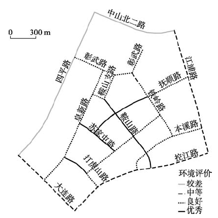
| 鞍山新村 | 20世纪50年代末 | 1.51 km2 | 内环以内,周边被四平路、大连路、中山北二路和内环高架路环绕 | 走马塘沿区域东侧经过,内部有松鹤公园,南部与大连路一路之隔有和平公园,具有人车混杂、狭窄逼仄、建筑街道界面混乱等旧城步行空间的共性问题 | 旧城典型代表,步行环境良莠不齐 |
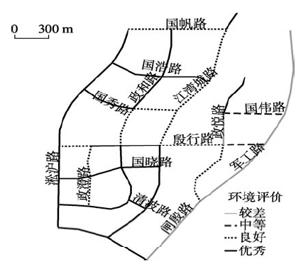
| 江湾新城 | 2000年之后建设完工 | 3.95 km2 | 中环和外环之间,被闸殷路、殷高东路、淞沪路和军工路环绕 | 内部有湿地公园,步行空间宽敞且绿化覆盖率较高,车流量和人流量均不大,但门禁式社区也造成了其以单调围墙为主的街道界面 | 新区典型代表,步行环境具有均好性 |
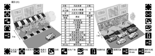
Tab. 2 Walking environment choice influencing factors and levels表2 步行环境选择影响要素及其水平 |
| 影响要素 | 水平1 | 水平2 | 水平3 |
|---|---|---|---|
| (路径)大交叉口数量(个) | 0 | 1 | 1,有天桥 |
| (路径)小交叉口数量(个) | 少量(2) | 多量(2) | |
| 人行道界面 | 绿化围墙 | 带咖啡座的建筑界面 | 橱窗建筑界面 |
| 是否有绿化隔离 | 有 | 无 | |
| 有效通行宽度(m)① | 较宽(3) | 较窄(3) | |
| 机动车流量大小② | 较少 | 较多 | |
| 人流量大小③ | 较少 | 较多 | |
| 遮荫情况④ | 较多 | 较少 | |
| 是否途经公园 | 是 | 否 | |
| 是否途经街头广场 | 是 | 否 | |
| 路径是否沿河 | 是 | 否 | |
| 是否需要原路返回 | 是 | 否 | |
| 是否有座椅 | 是 | 否 | |
| 步行路径长度(min) | 20 | 45 | 60 |
注:① 有效通行宽度:参照《城市步行和自行车交通系统规划设计导则》规定(在居住区支路人行道单侧宽度为2.5~4.5 m),以3 m为人行道宽窄的分界点。② 机动车流量大小:预调查发现,休闲步行活动的高峰时间与交通出行的早晚高峰有所重叠,早高峰7:00-8:00步行活动占总量的31.41%,晚高峰16:00-18:00占总量的14.84%。采用高峰小时机动车流量作为评价标准。③ 遮荫情况:参考《上海市林荫道评定办法(试行)》规定的林荫道标准,即人行道及非机动车道的绿荫覆盖率达90%以上,四车道以下的机动车道路绿荫覆盖率应达50%以上,四车道及以上的机动车道绿荫覆盖率应达30%以上。 |
Fig. 1 Questionnaire example图1 调研问卷举例 |
Tab. 3 The fitting result of the environment choice model表3 休闲步行环境选择行为模型拟合结果 |
| 鞍山新村 | 江湾新城 | ||
|---|---|---|---|
| 变量 | 变量系数值 | 变量系数值 | |
| (路径)小交叉口数量 | 少量(是=1) | - | 0.24535** |
| 步行环境界面 | 咖啡座建筑界面(是=1) | 0.23989* | 0.34758** |
| 橱窗建筑界面(是=1) | 0.30100** | 0.24964* | |
| 有效通行宽度 | 较宽(是=1) | 0.32680*** | 0.31974*** |
| 机动车流量大小 | 较少(是=1) | 1.16074*** | 1.39621*** |
| 人流量大小 | 较少(是=1) | 0.37100*** | 0.32877*** |
| 遮荫情况 | 较多(是=1) | 0.54764*** | 0.32628*** |
| 是否途径公园 | 是(是=1) | 0.33360*** | - |
| 是否沿河流 | 是(是=1) | 0.22466** | - |
| 对数似然数 | -350.5376 | -509.7804 | |
| 模型拟合优度 | 0.23146 | 0.18826 | |
注:***、**、*分别表示在0.001,0.05,0.1水平上显著,-表示不显著变量。 |
Fig. 2 Anshan Village walking environment evaluation图2 鞍山新村休闲步行环境的评价结果 |
Fig. 3 Jiangwan Town walking environment evaluation图3 江湾新城休闲步行环境的评价结果 |
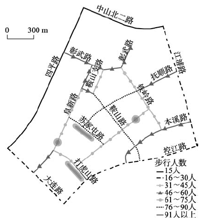
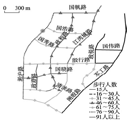
Fig. 4 Revealed preference of Anshan walking environment图4 鞍山新村步行环境实际使用情况 |
Fig. 5 Revealed preference of Jiang walking environment图5 江湾新城步行环境实际使用情况 |
The authors have declared that no competing interests exist.
| [1] |
ITDP, EPC.Better Streets, Better Cities: A Guide to Street Design in Urban India. Ahmedabad: ITDP, 2011.
|
| [2] |
Abu Dhabi Urban Planning Council. Abu Dhabi Urban Street Design Manual. Abu Dhabi: UPC, 2010.
|
| [3] |
San Francisco Planning Department. San Francisco Better Streets Plan. San Francisco: SFPD, 2010.
|
| [4] |
Transport for London. Streetscape Guidance 2009: A Guide to Better London Streets. London: TfL, 2009.
|
| [5] |
|
| [6] |
|
| [7] |
|
| [8] |
|
| [9] |
|
| [10] |
|
| [11] |
|
| [12] |
|
| [13] |
|
| [14] |
|
| [15] |
|
| [16] |
[
|
| [17] |
|
| [18] |
|
| [19] |
|
| [20] |
|
| [21] |
|
| [22] |
|
| [23] |
[
|
| [24] |
|
| [25] |
|
/
| 〈 |
|
〉 |