
Received date: 2017-10-15
Request revised date: 2018-01-19
Online published: 2018-04-20
Copyright
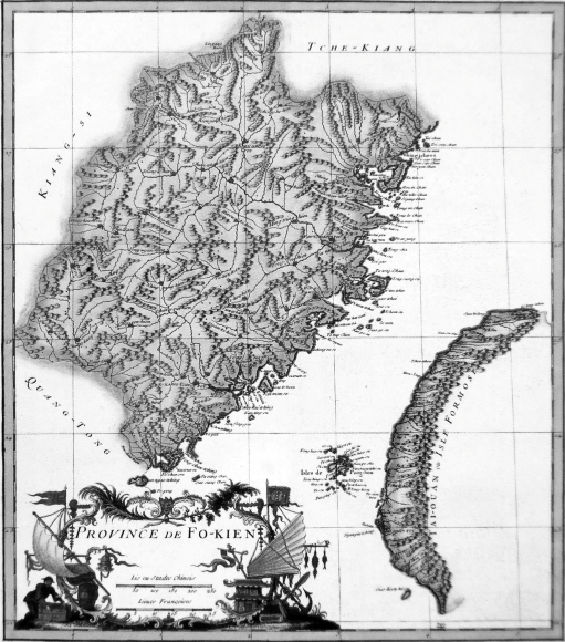
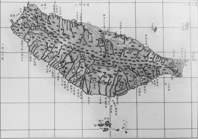
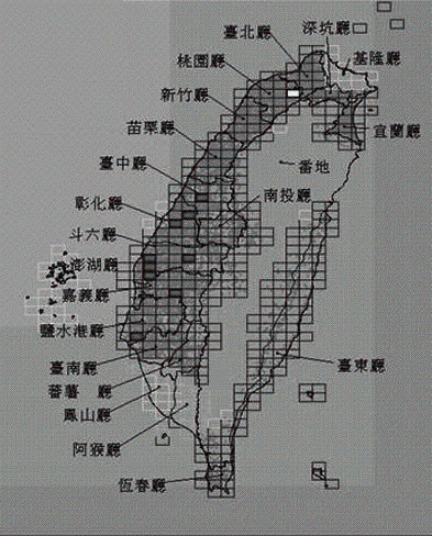
Modern map serves a kind of tool, for providing us a deeper understanding of Taiwan's economy and society. Our discussion is based on analysis of the time and space information displayed by the following three maps: the measured map drawn by the French missionary Feng Bingzheng in 1714, and the ‘overall map of the full geography of Taiwan' in 1891, the ‘fort map with the scale of one to twenty thousand' in 1904. We also referred to historical references and original data and discussed Taiwan's economic and social change and its main characteristics, especially during the period after being included into the territory of Qing Government. We have the following main conclusions: (1) At the beginning of the Qing Dynasty, Taiwan stayed in the early stage of economic and social development; (2) After the opening of ports and the beginning of trade in the late Qing Dynasty, the traditional Taiwan society headed for modern times. Gradually, it stepped into the stage of modernization; (3) During the Japanese-Occupied Period, the change of Taiwan's economy and society was closely related to the need of Japanese colonial governors. These conclusions are meaningful to understand Taiwan's economic and social changes. At the same time, they provide us experience for today's development.
Key words: modern map; Chinese Taiwan; economy and society; change
XIANG Wenhui . The Taiwan scene and changes in modern maps[J]. GEOGRAPHICAL RESEARCH, 2018 , 37(4) : 825 -833 . DOI: 10.11821/dlyj201804015
The authors have declared that no competing interests exist.
| [1] |
[
|
| [2] |
大日本帝国陆地测量部. 日治时代二万五千分之一台湾地形图. 台北: 远流出版公司, 1999.
[Terrestrial Survey Department of Japanese Empire. Taiwan's Topographic Map with the Scale of 1:25000 during the Japan Ruled Period. Taipei: Yuan-Liou Publishing Co. Ltd., 1999.]
|
| [3] |
[
|
| [4] |
[
|
| [5] |
[
|
| [6] |
大日本帝国陆地测量部. 日治时期五万分之一台湾地形图新解. 台北: 上河文化股份有限公司, 2007.
[Terrestrial Survey Department of Japanese Empire. New Explanations of Taiwan's Topographic Map with the Scale of 1:50000 during the Japan Ruled Period. Taipei: Shanghe Publishing Co. Ltd., 2007.]
|
| [7] |
[
|
| [8] |
[
|
| [9] |
[
|
| [10] |
[
|
| [11] |
[
|
| [12] |
[
|
| [13] |
[
|
| [14] |
[
|
| [15] |
[
|
| [16] |
[
|
| [17] |
[
|
| [18] |
[
|
| [19] |
[
|
| [20] |
[Ming Dynasty 'Fujian Coastal Map' research of names of placed in Taiwan test. National Sailing, 2015, 13(4): 157-174.]
|
| [21] |
[
|
| [22] |
[
|
| [23] |
[
|
| [24] |
[
|
| [25] |
[
|
| [26] |
[
|
| [27] |
[
|
| [28] |
[
|
| [29] |
[
|
| [30] |
[
|
| [31] |
[
|
| [32] |
[
|
| [33] |
[
|
| [34] |
清圣祖实录: 卷二七九: 康熙五十七年五月己未(影印). 北京: 中华书局, 1985.
[Record of Kangxi: Vol. 279: May, Jiwei, Kangxi Fifty-seven Years (photoprint). Beijing: Zhonghua Book Company, 1985.]
|
| [35] |
[
|
| [36] |
台湾史料集成编辑委员会. 明清台湾档案汇编: 第三辑第62册. 台北: 远流出版公司, 2007.
[Taiwan Historical Data Editorial Board editors. Ming and Qing Dynasties Taiwan Archives Compilation: Series 3, Vol. 62. Taipei: Yuan-Liou Publishing Co. Ltd., 2007.]
|
| [37] |
[
|
| [38] |
[
|
| [39] |
著者不详. 全台前后山总图. 清光绪年间刻本.
[Unknown authors. The Atlas of the Front and Back Mountain of Taiwan.Engraved copy in Qing Guangxi years.]
|
| [40] |
[
|
| [41] |
台湾省文献委员会. 台湾省通志: 卷二: 人民志·人口篇. 台北: 众文图书公司, 1980.
[Complied by Taiwan Document Committee. The Annal's of Taiwan: Vol. 2: Annals of Citizens, Annals of Population. Taipei: Jong Wen Books Co. Ltd., 1980.]
|
| [42] |
[
|
| [43] |
著者不详. 同治甲戌日兵侵台始末. 台北: 大通书局, 1959.
[
|
| [44] |
[
|
| [45] |
[
|
| [46] |
[
|
| [47] |
[
|
| [48] |
[
|
| [49] |
[
|
| [50] |
[
|
| [51] |
[
|
| [52] |
[
|
/
| 〈 |
|
〉 |