
Development and spatio-temporal evolution of cross Yangtze highway passages in the lower Yangtze region
Received date: 2018-05-30
Request revised date: 2018-10-08
Online published: 2019-08-20
Copyright
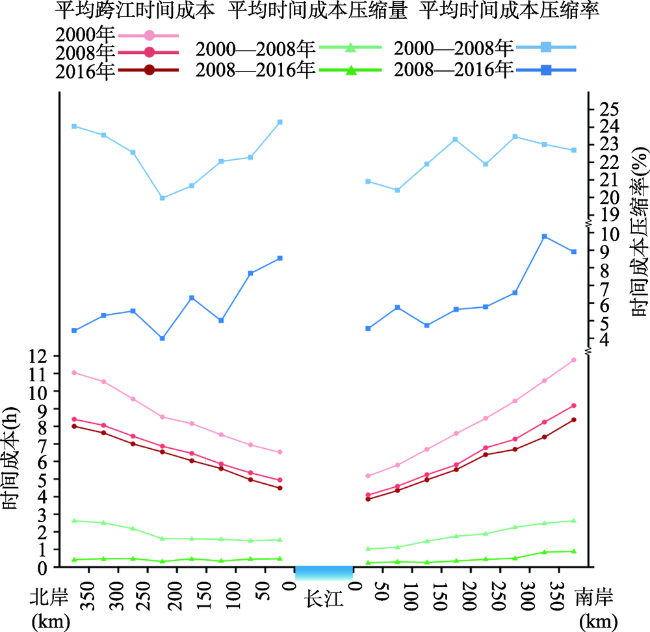
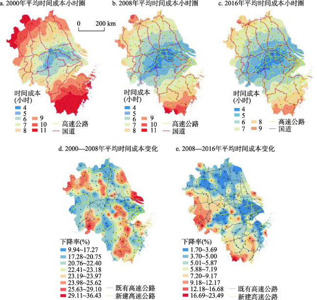
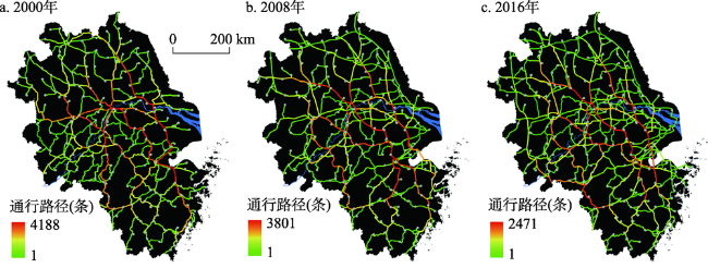
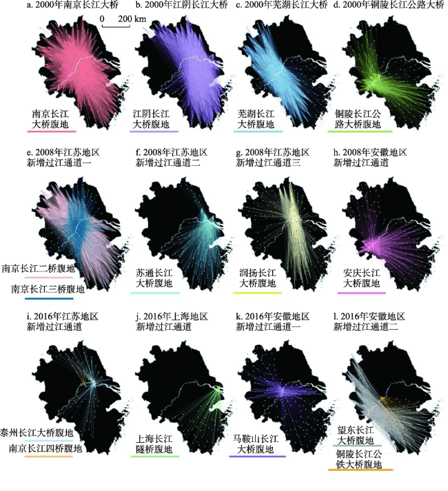
For a long time, the contradiction between supply and demand of cross Yangtze highway passages has been prominent. Making use of existing channels while rationally planning and building new channel infrastructures, which aims at attracting barrier-free circulation of elements has become the material basis to promote the development of cross river integration and sub-regional cooperation in the lower reaches of the Yangtze River. In this article, we analyze spatio-temporal effect on river-crossing transportation development since 2000, which is caused by the construction of cross Yangtze highway passages in the lower Yangtze region. Also, we attempt to explore the location difference and spatial characteristics of utilization among passages in the high grade road network system. By the end of 2016, the number of crossings of the Yangtze River had increased from 4 to 17. The average cross-river time of cities and counties had decreased from 7.92 h to 5.75 h. The time cost of river crossing rises in line with the shore distance, showing a little ups and downs in the process. The amplitude of cost increased slightly larger in the south than that in the north. The cost reduction rate from 2000 to 2008 was higher than that of 2008-2016. The construction of the passageway was expanded from point to surface, which enables more cities to enter the river passages within a reasonable amount of time. Cross river accessibility pattern had gradually changed from a radial structure centered in Nanjing to gradient transformation from the shore. From 2000 to 2008, high level of time compression occurred throughout the region, forming a traffic oriented mode. From 2008 to 2016, there was a slight cost reduction, but the difference in cross-river time cost in the rear area was amplified. The edge of research area remained a high level of decline which had inherent weakness of channel access. The condition of river crossing changed from single type to diversity, and the development chance for the compressed rear area was unfair, due to locational difference. With the increasing number of channel, their utilization became different. Nanjing, the hub node of river crossing in the lower Yangtze region, supports all directions of river crossing transportation using gradually improved radial high-grade highway network. Jiangyin Bridge is responsible for river crossing from the north to the south in the east part of the research area and shore area of Jiangsu province. Its unique high-grade highway network seamlessly guides the use of remote cities and counties. Wuhu Bridge and Tongling Bridge are the first bridges which jointly undertake the responsibility of river crossing in Anhui province. Subsequently, Anqing Bridge serves as the passage between cities on the west bank along the Yangtze River in Anhui province and most cities on the south bank as well as the central and north parts of Anhui. After 2008, only the Wangdong Bridge has acted as a leading role in the river-crossing transportation of north-south and northeast-southwest of the study area. In addition, the areas along the Yangtze River have been affected greatly thanks to the most direct improvement of river-crossing condition made by the new passages. With the increasing distance from shore, it is more likely to have access to the passageway quickly. Through the high grade highway, cities in a certain range can be linked to the direction of the specific passage, forming a "confluence" structure. It can be concluded that a mature and complete passageway should be a transportation corridor that includes a bridge over the river and a high grade link in the rear. The disparity of utilization originated from the difference in the positioning of each passage. Because of regional space and infrastructure construction limitations, networked efficient transportation requires establishing multiple paths to reasonably distribute river crossing in the process of advancing to the coast. "Many-to-many" river-crossing selection between passages and trunk highways can be finally formed in order to improve existing passages' traffic capacity and divert cross-river traffic pressure.
LIU Weichen , CAO Youhui , WU Wei , GUO Jiaying . Development and spatio-temporal evolution of cross Yangtze highway passages in the lower Yangtze region[J]. GEOGRAPHICAL RESEARCH, 2019 , 38(8) : 1905 -1918 . DOI: 10.11821/dlyj020180518
表1 研究选取的边界区域Tab. 1 Boundary areas selected in this study |
| 编号 | 2000年 | 2008年 | 2016年 | 连接方向 | |
|---|---|---|---|---|---|
| 北岸 | N1 | 国道G204苏鲁省界 | 国高速G15苏鲁省界 | 国高速G15苏鲁省界 | 青岛、烟台、日照等山东半岛方向 |
| N2 | 国高速G2苏鲁省界 | 国高速G2苏鲁省界 | 国高速G2苏鲁省界 | 临沂、济南、天津等华北东北方向 | |
| N3 | 国道G104苏鲁省界 | 国高速G3苏鲁省界 | 国高速G3苏鲁省界 | 枣庄、济南、北京等华北东北方向 | |
| N4 | 国道G310苏豫省界 | 国高速G30/35虞城 枢纽 | 国高速G30/35虞城枢纽 | 商丘、郑州、西安等中西部方向 | |
| N5 | 皖省道S102皖豫省界 | 国高速G36皖豫省界 | 国高速G36皖豫省界 | 周口、洛阳、太原等中西部方向 | |
| N6 | 国道G312皖豫省界 | 国道G312皖豫省界 | 国高速G40皖豫省界 | 信阳、南阳、西安等中西部方向 | |
| N7 | 皖省道S210皖鄂省界 | 国高速G42皖鄂省界 | 国高速G42皖鄂省界 | 武汉、宜昌、重庆等中西部方向 | |
| N8 | 国道G105皖鄂省界 | 国高速G50黄梅互通 | 国高速G50/70黄梅枢纽 | 黄冈、武汉、荆州等中西部方向 | |
| 南岸 | S1 | 皖省道S301皖赣省界 | 皖省道S301皖赣省界 | 皖高速S20皖赣省界 | 九江、岳阳、贵阳等中西部方向 |
| S2 | 皖省道S302皖赣省界 | 皖省道S302皖赣省界 | 国高速G35/皖高速S29桃墅店枢纽 | 景德镇、鹰潭、广州等华东华南方向 | |
| S3 | 皖省道S201皖赣省界 | 国高速G56皖赣省界 | 国高速G56皖赣省界 | 景德镇、九江、岳阳等中西部方向 | |
| S4 | 国道G320浙赣省界 | 国高速G60浙赣省界 | 国高速G60浙赣省界 | 南昌、长沙、昆明等中西部方向 | |
| S5 | 国道G205浙赣省界 | 国道G205浙赣省界 | 国高速G3浙赣省界 | 南平、福州、厦门等沿海方向 | |
| S6 | 浙省道S229浙闽省界 | 浙省道S229浙闽省界 | 国高速G25浙闽省界 | 三明、梅州、深圳等华南方向 | |
| S7 | 国道G104浙闽省界 | 国高速G15浙闽省界 | 国高速G15浙闽省界 | 福州、泉州、厦门等沿海方向 | |
表2 长江下游公路过江通道的基本信息Tab. 2 Basic information of cross Yangtze highway passages in the lower Yangtze region |
| 过江通道名称 | 南北岸市县 | 通车年份 | 限速 | 通道简介 | |
|---|---|---|---|---|---|
| 南岸 | 北岸 | ||||
| 上海长江隧桥 | 上海市区 | 启东市 | 2015 | 隧道:80 km/h | 双向6车道高速公路 |
| 桥梁:100 km/h | |||||
| 苏通长江大桥 | 常熟市 | 南通市区 | 2008 | 100 km/h | 双向6车道高速公路 |
| 江阴长江大桥 | 江阴市 | 靖江市 | 1999 | 100 km/h | 双向6车道高速公路 |
| 泰州长江大桥 | 泰州市区 | 扬中市 | 2012 | 100 km/h | 双向6车道高速公路 |
| 润扬长江大桥 | 镇江市区 | 扬州市区 | 2005 | 100 km/h | 双向6车道高速公路 |
| 南京长江四桥 | 南京市区 | 南京市区 | 2012 | 100 km/h | 双向6车道高速公路 |
| 南京长江二桥 | 南京市区 | 南京市区 | 2001 | 100 km/h | 双向6车道高速公路 |
| 南京长江大桥 | 南京市区 | 南京市区 | 1968 | 50 km/h | 双向4车道城市快速路 |
| 南京扬子江隧道 | 南京市区 | 南京市区 | 2016 | 70 km/h | 双向8车道城市快速路 |
| 南京长江隧道 | 南京市区 | 南京市区 | 2010 | 80 km/h | 双向6车道城市快速路 |
| 南京长江三桥 | 南京市区 | 南京市区 | 2005 | 100 km/h | 双向6车道高速公路 |
| 马鞍山长江大桥 | 马鞍山市区 | 和县 | 2013 | 100 km/h | 双向6车道高速公路 |
| 芜湖长江大桥 | 芜湖市区 | 无为县 | 2000 | 70 km/h | 双向4车道城市快速路 |
| 铜陵长江公铁大桥 | 铜陵市区 | 无为县 | 2015 | 100 km/h | 双向6车道高速公路 |
| 铜陵长江公路大桥 | 铜陵市区 | 枞阳县 | 1995 | 60 km/h | 双向4车道城市快速路 |
| 安庆长江大桥 | 东至县 | 安庆市区 | 2004 | 100 km/h | 双向4车道高速公路 |
| 望东长江大桥 | 东至县 | 望江县 | 2016 | 100 km/h | 双向6车道高速公路 |
| [1] |
荣朝和 . 西方运输经济学. 北京: 经济科学出版社, 2002.
[
|
| [2] |
周恺 . 长江三角洲高速公路网通达性与城镇空间结构发展. 地理科学进展, 2010,29(2):241-248.
[
|
| [3] |
|
| [4] |
方创琳, 宋吉涛, 蔺雪芹 . 中国城市群可持续发展理论与实践. 北京: 科学出版社, 2010.
[
|
| [5] |
|
| [6] |
陆大道 . 区域发展及其空间结构. 北京: 科学出版社, 1995.
[
|
| [7] |
吴威, 曹有挥, 曹卫东 , 等. 开放条件下长江三角洲区域的综合交通可达性空间格局. 地理研究, 2007,26(2):391-402.
[
|
| [8] |
|
| [9] |
明立波, 甄峰, 郑俊 . 无锡-南通过江通道建设构想及其区域经济影响评价. 人文地理, 2007,22(4):105-109.
[
|
| [10] |
苗长虹, 王海江 . 河南省城市的经济联系方向与强度: 兼论中原城市群的形成与对外联系. 地理研究, 2006,25(2):222-232.
[
|
| [11] |
王成金 . 中国高速公路网的发展演化及区域效应研究. 地理科学进展, 2006,25(6):126-137.
[
|
| [12] |
|
| [13] |
|
| [14] |
陆大道 . 关于渤海海峡跨海通道规划建设的几个问题. 鲁东大学学报: 社会科学版, 2009,26(2):8-9.
[
|
| [15] |
|
| [16] |
|
| [17] |
虞孝感 . 长江流域可持续发展研究. 北京: 科学出版社, 2003.
[
|
| [18] |
|
| [19] |
沈丽珍, 顾朝林 . 区域流动空间整合与全球城市网络构建. 地理科学, 2009,29(6):787-793.
[
|
| [20] |
陈博文, 陆玉麒, 柯文前 , 等. 江苏交通可达性与区域经济发展水平关系测度: 基于空间计量视角. 地理研究, 2015,34(12):2283-2294.
[
|
| [21] |
孙峰华, 陆大道, 柳新华 , 等. 中国物流发展对渤海海峡跨海通道建设的影响. 地理学报, 2010,65(12):1507-1521.
[
|
| [22] |
陆玉麒, 董平 . 新时期推进长江经济带发展的三大新思路. 地理研究, 2017,36(4):605-615.
[
|
| [23] |
吴旗韬, 张虹鸥, 叶玉瑶 , 等. 基于交通可达性的港珠澳大桥时空压缩效应. 地理学报, 2012,67(6):723-732.
[
|
| [24] |
冯立新, 杨效忠, 姚慧 , 等. 骨干交通设施对区域旅游空间格局的影响: 以渤海海峡跨海通道为例. 经济地理, 2011,31(2):189-194.
[
|
| [25] |
蒋海兵, 徐建刚, 商硕 . 过江通道对乡镇可达性影响分析. 长江流域资源与环境, 2010,19(5):506-516.
[
|
| [26] |
吴扬, 徐建刚, 王振波 , 等. 基于GIS技术的扬中市可达性定量研究: 以过江通道的建设为例. 地域研究与开发, 2008,27(5):124-128.
[
|
| [27] |
李平华, 陆玉麒 . 可达性研究的回顾与展望. 地理科学进展, 2005,24(3):69-78.
[
|
| [28] |
王成金, 王伟, 张梦天 , 等. 中国道路网络的通达性评价与演化机理. 地理学报, 2014,69(10):1496-1509.
[
|
| [29] |
孟德友, 陆玉麒, 李小建 , 等. 长江三角洲高速公路网络构建对区域可达性的影响. 热带地理, 2014,34(5):643-654.
[
|
| [30] |
张莉, 陆玉麒 . 基于陆路交通网的区域可达性评价: 以长江三角洲为例. 地理学报, 2006,61(12):1235-1246.
[
|
| [31] |
曹小曙, 阎小培 . 经济发达地区交通网演化对通达性空间格局的影响: 以广东省东莞市为例. 地理研究, 2003,22(3):305-312.
[
|
| [32] |
吴威, 陈雯, 曹有挥 . 过江通道建设对相对落后地区发展的影响: 以江苏省南通市为例. 长江流域资源与环境, 2009,18(5):397-402.
[
|
| [33] |
吴旗韬, 樊杰, 张虹鸥 , 等. 跨海通道空间效益模型: 以珠江口跨海通道为例. 地理研究, 2015,34(11):2061-2072.
[
|
| [34] |
蓝志威, 吴旗韬, 周智勇 . 深圳-中山跨珠江通道对珠江三角洲地区可达性的空间效应. 热带地理, 2016,36(6):1019-1025.
[
|
| [35] |
|
| [36] |
|
| [37] |
|
| [38] |
|
| [39] |
陈娱, 金凤君, 陆玉麒 , 等. 京津冀地区陆路交通网络发展过程及可达性演变特征. 地理学报, 2017,72(12):2252-2264.
[
|
/
| 〈 |
|
〉 |