
Research on a comprehensive map of layout of population and settlements planning in both urban and rural areas for territory spatial planning
Received date: 2019-04-28
Request revised date: 2019-09-27
Online published: 2019-10-30
Copyright
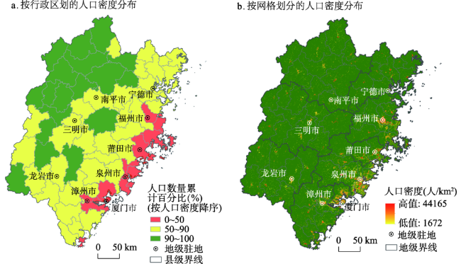
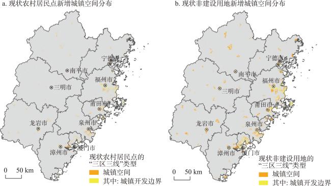
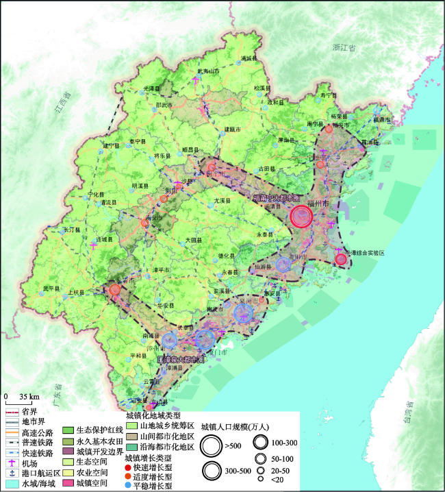
In order to promote "Three Zones and Three Lines" layout (Three Zones represent ecological space, agricultural space, and urban space; Three Lines represent ecological conservation redline, permanent capital farmland, and urban development boundary) in the territory spatial planning system, it is important to develop the methods of population and settlements planning in both urban and rural areas. This paper aims to put forward a series of methods, which focus on not only the top-down planning but also the bottom-up planning. First, the total population and the urbanization level in the macro scale should be controlled. Using the classic estimation methods in the field of demography, including cohort-component method and the United Nations urbanization projection method, the population and urbanization level based on the administrative units can be figured out. Second, the population size should be adapted to local environment conditions. According to the method of demographic data spatialization, the urban and rural population by the grid format can be estimated. Furthermore, the overload population and the additional population can be calculated based on the population raster data and the layout of "Three Zones and Three Lines". Third, the elastic integration is necessary. The integration considers not only spatial-temporal changes of population and urbanization but also the requests of local governments and residents. The layouts of population and settlements in both urban and rural areas include the regional types of population development and the hierarchical structure of the city system. We further applied our method into the provincial-scale spatial planning in Fujian. We do hope that this paper could be beneficial for the related population and urban-rural spatial planning in other regions or other geographic scales.
QI Wei , LIU Shenghe , ZHOU Kan , QI Honggang . Research on a comprehensive map of layout of population and settlements planning in both urban and rural areas for territory spatial planning[J]. GEOGRAPHICAL RESEARCH, 2019 , 38(10) : 2473 -2485 . DOI: 10.11821/dlyj020190331
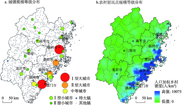
表1 2030年福建省城镇规模等级表Tab. 1 Cities' list based on the scale hierarchy in Fujian province in 2030 |
| 规模等级 | 城镇数量(个) | 城镇名称 |
|---|---|---|
| 特大城市 | 1 | 福州 |
| I型大城市 | 2 | 厦门、泉州 |
| II型大城市 | 2 | 莆田、漳州 |
| 中等城市 | 2 | 龙岩、平潭 |
| I型小城市 | 7 | 三明、南平、宁德、永安、南安、福安、福鼎 |
| II型小城市(小城镇) | 43 | 闽清、永泰、明溪、清流、宁化、大田、尤溪、沙县、将乐、泰宁、建宁、惠安、安溪、永春、德化、云霄、漳浦、诏安、长泰、东山、南靖、平和、华安、邵武、武夷山、建瓯、顺昌、浦城、光泽、松溪、政和、漳平、长汀、上杭、武平、连城、霞浦、古田、屏南、寿宁、周宁、柘荣、仙游 |
注:考虑到未来行政区划调控或管理空间重构,福州城区由福州老城区(含闽侯)和福州新区组成,其中福州新区包括滨海新城、福清组团和罗源组团等三大城市组团;泉州城区包括目前的泉州城区、晋江城区和石狮城区,通过行政区划调整和环湾一体化发展,整合成为一座环泉州湾大城市;漳州城区包括漳州老城区和龙海新城区。 |
| [1] |
陆大道, 陈明星 . 关于“国家新型城镇化规划(2014-2020)”编制大背景的几点认识. 地理学报, 2015,70(2):179-185.
[
|
| [2] |
姚士谋, 张平宇, 余成 , 等. 中国新型城镇化理论与实践问题. 地理科学, 2014,6(6):641-647.
[
|
| [3] |
樊杰, 王亚飞, 汤青 , 等. 全国资源环境承载能力监测预警(2014版)学术思路与总体技术流程. 地理科学, 2015,35(1):1-10.
[
|
| [4] |
封志明, 杨艳昭, 闫慧敏 , 等. 百年来的资源环境承载力研究: 从理论到实践. 资源科学, 2017,39(3):379-395.
[
|
| [5] |
张永姣, 方创琳 . 空间规划协调与多规合一研究: 评述与展望. 城市规划学刊, 2016, ( 2):78-87.
[
|
| [6] |
谢英挺, 王伟 . 从“多规合一”到空间规划体系重构. 城市规划学刊, 2015, ( 3):15-21.
[
|
| [7] |
任强, 侯大道 . 人口预测的随机方法: 基于Leslie矩阵和ARMA模型. 人口研究, 2011,35(2):28-42.
[
|
| [8] |
秦中春 . 中国未来人口变化的三大转折点预测: 基于年龄移算人口预测模型的分析. 区域经济评论, 2013, ( 5):5-14.
[
|
| [9] |
高成修 . 人口规划模型及其评估方法. 系统工程, 1992, ( 3):7-12.
[
|
| [10] |
王焕清 . 不同计划生育政策下的我国人口预测研究. 统计与决策, 2013, ( 5):9-13.
[
|
| [11] |
童玉芬, 王静文, 梁钊 . 资源环境约束下的中国适度人口研究. 社会科学文摘, 2016,40(2):3-11.
[
|
| [12] |
封志明, 杨艳昭, 游珍 , 等. 基于分县尺度的中国人口分布适宜度研究. 地理学报, 2014,69(6):723-737.
[
|
| [13] |
张泉, 刘剑 . 城镇体系规划改革创新与“三规合一”的关系: 从“三结构一网络”谈起. 城市规划, 2014,38(10):13-27.
[
|
| [14] |
易斌, 翟国方 . 我国城镇体系规划与研究的发展历程、现实困境和展望. 规划师, 2013,29(5):81-85.
[
|
| [15] |
刘玉亭, 何深静, 魏立华 . 论城镇体系规划理论框架的新走向. 规划研究, 2008, ( 3):41-44.
[
|
| [16] |
李兵弟, 徐会夫 . 中国城乡空间规划的新发展: 以省域城镇体系规划为例. 规划研究, 2004, ( 12):9-14.
[
|
| [17] |
宋家泰, 顾朝林 . 城镇体系规划的理论与方法初探. 地理学报, 1988,43(2):97-107.
[
|
| [18] |
阎小培, 方远平 . 全球化时代城镇体系规划理论与模式探新: 以广东省阳江市为例. 城市规划, 2002,26(6):40-45.
[
|
| [19] |
胡耀文, 尹强 . 海南省空间规划的探索与实践: 以《海南省总体规划(2015—2030)》为例. 城市规划学刊, 2016, ( 3):55-62.
[
|
| [20] |
樊杰 . 人文-经济地理学和区域发展研究基本脉络的透视: 对该领域在中国科学院地理科学与资源研究所发展历程的讨论. 地理科学进展, 2011,30(4):387-396.
[
|
| [21] |
胡焕庸 . 中国人口之分布: 附统计表与密度图. 地理学报, 1935,2(2):33-74.
[
|
| [22] |
|
| [23] |
|
| [24] |
|
| [25] |
姚士谋, 周春山, 王德 , 等. 中国城市群新论. 北京: 科学出版社, 2016.
[
|
| [26] |
邓羽, 刘盛和, 蔡建明 , 等. 中国省际人口空间格局演变分析方法与实证. 地理学报, 2014,69(10):1473-1486.
[
|
| [27] |
翟振武, 李龙, 陈佳鞠 , 等. 人口预测在PADIS-INT软件中的应用: MORTPAK、Spectrum和PADIS-INT比较分析. 人口研究, 2017,41(6):84-97.
[
|
| [28] |
|
| [29] |
朱建华, 陈田, 王开泳 , 等. 改革开放以来中国行政区划格局演变与驱动力分析. 地理研究, 2015,34(2):247-258.
[
|
| [30] |
戚伟, 刘盛和, 金浩然 . 中国城市规模划分新标准的适用性研究. 地理科学进展, 2016,35(1):47-56.
[
|
| [31] |
戚伟, 王开泳 . 中国城市行政地域与实体地域的空间差异及优化整合. 地理研究, 2019,38(2):207-220.
[
|
/
| 〈 |
|
〉 |