
Evaluation method of infrastructure interconnection between China and other countries along the Belt and Road and its spatial pattern
Received date: 2019-09-12
Request revised date: 2020-05-14
Online published: 2021-02-20
Copyright
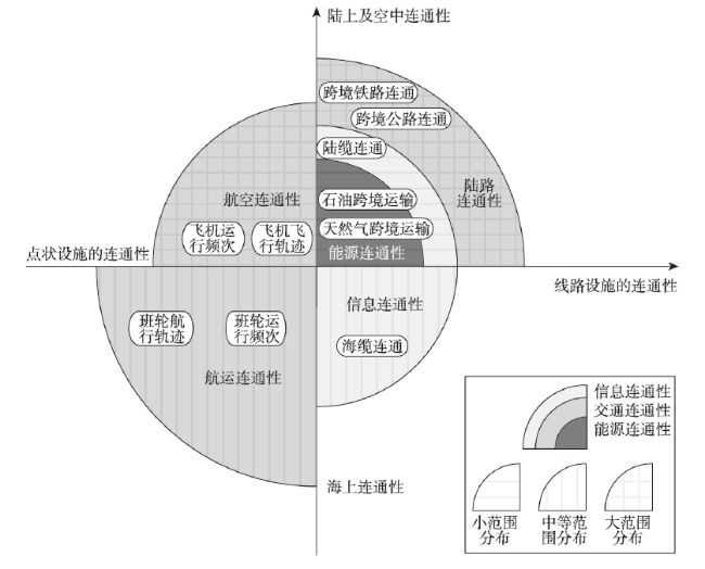
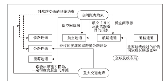
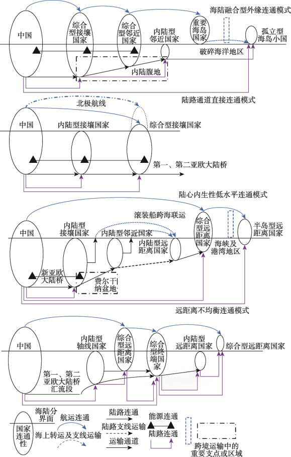
The infrastructure is the basic bearing body of social and economic relation among the regions or countries and is the main part of interregional networks, which plays an important role in the interregional flow of product, market integration and resources allocation. Furthermore, the interconnection of infrastructure network is the important task and prerequisite of the Belt and Road. In this paper, based on the integrated infrastructure networks, we designed the model and evaluated the infrastructure interconnection between China and other countries along the Belt and Road, and analyzed the basic features and spatial pattern, and examined the interconnection level of different infrastructure networks, including railway, road, shipping, aviation, communication and energy infrastructure networks, discussed the type differentiation and its leading factors of infrastructure interconnection, and summarized the spatial mode of infrastructure interconnection. The main conclusions are as follows: (1) From the perspective of land-sea attribute, island countries' infrastructure connectivity with China is the highest, followed by comprehensive countries, and the inland countries' connectivity is the lowest. For the international regions, Russia-Mongolia region and Southeast Asia have the highest connectivity with China, while Central and Eastern Europe have the lowest. On national scale, the countries whose connectivity with China is the highest include Russia and Vietnam, while Palestine, East Timor and other five countries have not yet formed connectivity with China. From the composition of connection modes, the connectivity of shipping network is the highest, followed by aviation and optical cable. (2) Spatial distance, connection mode and major transportation corridors together dominate the formation of type differentiation of infrastructure connectivity. (3) Four typical spatial patterns of infrastructure connectivity between the countries along the Belt and Road and China have been formed, namely, land-sea integration external connectivity pattern, direct connectivity through land corridor pattern, endogenous low-level inland connectivity pattern and remote unbalanced connectivity pattern.
Key words: China; the Belt and Road; infrastructure; interconnection; spatial pattern
WANG Chengjin , CHEN Peiran , WANG Jiao'e , LI Na . Evaluation method of infrastructure interconnection between China and other countries along the Belt and Road and its spatial pattern[J]. GEOGRAPHICAL RESEARCH, 2020 , 39(12) : 2685 -2704 . DOI: 10.11821/dlyj020200798
表1 中国与“一带一路”沿线国家基础设施连通性评价表Tab. 1 Evaluation index of infrastructure interconnection between China and other countries along the Belt and Road |
| 指标集 | 分值 | 指标集 | 分值 | 指标 |
|---|---|---|---|---|
| 航运 | 30.0 | 航线 | 24.0 | 集装箱直达航线 |
| 班轮 | 6.0 | 集装箱班轮数量 | ||
| 铁路 | 25.0 | 设施连通 | 20.0 | 直接连通 |
| 间接连通 | ||||
| 跨境常态化运输 | 5.0 | 班列线路 | ||
| 班列频率/周 | ||||
| 公路 | 15.0 | 设施连通 | 15.0 | 干线公路直接连通数 |
| 干线公路间接连通数 | ||||
| 航空 | 15.0 | 直达航线 | 12.0 | 直达航线数量 |
| 航班密度 | 3.0 | 直达航班频率/周 | ||
| 信息 | 10.0 | 光缆数量 | 10.0 | 条 |
| 能源 | 5.0 | 天然气管道 | 2.5 | 条 |
| 原油管道 | 2.5 | 条 |
表2 “一带一路”沿线区域和国家基础设施综合连通性Tab. 2 Infrastructure connectivity of regions and countries along the Belt and Road |
| 区域 | 区域 连通性 | 国家 | 分类 | 国家 连通性 | 国家 | 分类 | 国家 连通性 |
|---|---|---|---|---|---|---|---|
| 东南亚 | 59.65 | 东帝汶 | 岛屿型 | 0.00 | 泰国 | 综合型 | 59.87 |
| 菲律宾 | 岛屿型 | 80.00 | 文莱 | 岛屿型 | 67.17 | ||
| 柬埔寨 | 综合型 | 57.23 | 新加坡 | 综合型 | 55.01 | ||
| 老挝 | 内陆型 | 41.81 | 印度尼西亚 | 岛屿型 | 80.00 | ||
| 马来西亚 | 综合型 | 55.29 | 越南 | 综合型 | 91.18 | ||
| 缅甸 | 综合型 | 68.60 | |||||
| 独联体 | 24.47 | 阿塞拜疆 | 内陆型 | 20.14 | 摩尔多瓦 | 综合型 | 2.99 |
| 白俄罗斯 | 内陆型 | 48.05 | 乌克兰 | 综合型 | 60.57 | ||
| 格鲁吉亚 | 综合型 | 14.61 | 亚美尼亚 | 内陆型 | 0.48 | ||
| 俄蒙 | 81.76 | 俄罗斯 | 综合型 | 94.00 | 蒙古 | 内陆型 | 69.52 |
| 南亚 | 39.46 | 阿富汗 | 内陆型 | 19.94 | 孟加拉国 | 综合型 | 29.50 |
| 巴基斯坦 | 综合型 | 63.76 | 尼泊尔 | 内陆型 | 44.90 | ||
| 不丹 | 内陆型 | 9.95 | 斯里兰卡 | 岛屿型 | 71.11 | ||
| 马尔代夫 | 岛屿型 | 12.60 | 印度 | 综合型 | 63.94 | ||
| 西亚北非 | 29.38 | 阿联酋 | 综合型 | 51.94 | 沙特阿拉伯 | 综合型 | 42.59 |
| 阿曼 | 综合型 | 39.50 | 土耳其 | 综合型 | 53.22 | ||
| 埃及 | 综合型 | 53.14 | 叙利亚 | 综合型 | 0.05 | ||
| 巴勒斯坦 | 内陆型 | 0.00 | 也门 | 综合型 | 10.00 | ||
| 巴林 | 综合型 | 24.03 | 伊拉克 | 综合型 | 28.02 | ||
| 卡塔尔 | 综合型 | 49.10 | 伊朗 | 综合型 | 52.53 | ||
| 科威特 | 综合型 | 24.02 | 以色列 | 综合型 | 31.95 | ||
| 黎巴嫩 | 综合型 | 0.01 | 约旦 | 综合型 | 10.01 | ||
| 中东欧 | 12.7 | 阿尔巴尼亚 | 综合型 | 0.00 | 拉脱维亚 | 综合型 | 8.84 |
| 爱沙尼亚 | 综合型 | 6.10 | 立陶宛 | 综合型 | 7.77 | ||
| 保加利亚 | 综合型 | 0.29 | 罗马尼亚 | 综合型 | 26.94 | ||
| 波兰 | 综合型 | 63.16 | 马其顿 | 内陆型 | 0.04 | ||
| 波黑 | 内陆型 | 0.04 | 塞尔维亚 | 内陆型 | 0.81 | ||
| 黑山 | 综合型 | 0.02 | 斯洛伐克 | 内陆型 | 7.29 | ||
| 捷克 | 内陆型 | 22.40 | 斯洛文尼亚 | 综合型 | 24.12 | ||
| 克罗地亚 | 综合型 | 24.21 | 匈牙利 | 综合型 | 11.24 | ||
| 中亚 | 39.66 | 哈萨克 | 内陆型 | 75.50 | 土库曼 | 内陆型 | 17.04 |
| 吉尔吉斯 | 内陆型 | 47.08 | 乌兹别克 | 内陆型 | 22.80 | ||
| 塔吉克 | 内陆型 | 35.89 |
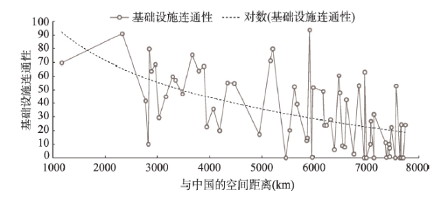
图2 “一带一路”沿线地区基础设施连通性分布的距离衰减规律Fig. 2 Distance attenuation law for infrastructure interconnection distribution along the Belt and Road |
表3 空间距离主导下的基础设施连通性分异类型Tab. 3 Distance-dominated differential types of infrastructure interconnection |
| 低连通性 | 高连通性 | |
|---|---|---|
| 空间距离邻近 | 老挝、不丹、孟加拉国、尼泊尔、乌兹别克、塔吉克 | 越南、菲律宾、巴基斯坦、缅甸、泰国、柬埔寨、吉尔吉斯、哈萨克、印度、文莱 |
| 空间距离遥远 | 阿富汗、土库曼、东帝汶、阿塞拜疆、马尔代夫、格鲁吉亚、亚美尼亚、巴林、科威特、爱沙尼亚、拉脱维亚、立陶宛、摩尔多瓦、叙利亚、黎巴嫩、约旦、巴勒斯坦、匈牙利、保加利亚、也门、塞尔维亚、斯洛伐克、马其顿、波黑、黑山、阿尔巴尼亚 | 马来西亚、新加坡、斯里兰卡、印度尼西亚、伊朗、阿曼、俄罗斯、阿联酋、卡塔尔、乌克兰、白俄罗斯、沙特阿拉伯、土耳其、波兰、罗马尼亚、以色列、捷克、埃及、克罗地亚、斯洛文尼亚 |
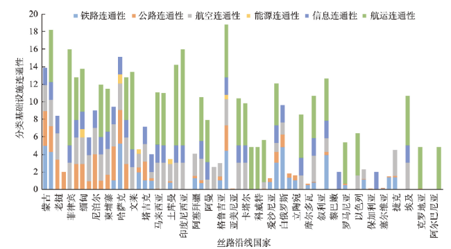
表4 交通方式主导下的国家基础设施连通性分异类型Tab. 4 Differential types of infrastructure interconnection under the dominance of transport mode |
| 分异类型 | 国家 |
|---|---|
| 铁路主导型 | 斯洛伐克、塞尔维亚、摩尔多瓦、拉脱维亚、黑山、爱沙尼亚、立陶宛、保加利亚、马其顿、白俄罗斯、匈牙利、波黑、乌兹别克 |
| 公路主导型 | 不丹、黎巴嫩、叙利亚、亚美尼亚、阿尔巴尼亚、波黑、尼泊尔、吉尔吉斯、老挝 |
| 航空主导型 | 马尔代夫、捷克、阿塞拜疆、土库曼、格鲁吉亚、孟加拉国、匈牙利 |
| 航运主导型 | 巴林、科威特、斯洛文尼亚、克罗地亚、罗马尼亚、伊拉克、以色列、菲律宾、印度尼西亚、文莱、斯里兰卡、阿曼、沙特阿拉伯、新加坡、马来西亚、埃及、阿联酋、泰国、卡塔尔、伊朗、土耳其、柬埔寨 |
| 通信主导型 | 也门、约旦、阿富汗 |
| 均衡型 | 缅甸、哈萨克、俄罗斯、塔吉克、蒙古、巴基斯坦、印度、越南、乌克兰、波兰 |
| 无连通 | 东帝汶、巴勒斯坦 |
| 能源保障型 | 土库曼、乌兹别克、缅甸、哈萨克、俄罗斯 |
真诚感谢匿名评审专家在论文评审中所付出的时间和精力,评审专家对本文的内容结构、文字表述、连通性指标赋权和连通性计算模型方面的修改意见,使本文获益匪浅。
| [1] |
刘育红, 王曦. “新丝绸之路”经济带交通基础设施与区域经济一体化: 基于引力模型的实证研究. 西安交通大学学报: 社会科学版, 2014,34(2):43-48, 80.
[
|
| [2] |
黄先海, 陈航宇. “一带一路”的实施效应研究: 基于GTAP的模拟分析. 社会科学战线, 2016, (5):39-49, 2.
[
|
| [3] |
章庆慧, 蔡畅. “丝绸之路经济带”构想下的“无差异空间”与区域合作: 论中国与中亚的交通运输合作. 欧亚经济, 2014, (6):66-77, 124.
[
|
| [4] |
王琴梅, 曹琼. “一带一路”道路联通的现状、阻滞因素及推进建议. 发展研究, 2015, (10):17-21.
[
|
| [5] |
魏敏. “一带一路”框架下中国与中东基础设施互联互通问题研究. 国际经济合作, 2017, (12):58-63.
[
|
| [6] |
赵振宇, 李兴才, 姚蒙蒙. “一带一路”沿线国家基础设施现状及市场机会研究. 建筑经济, 2016,37(7):5-10.
[
|
| [7] |
杨道玲, 王璟璇, 李祥丽. “一带一路”沿线国家信息基础设施发展水平评估报告. 电子政务, 2016, (9):2-15.
[
|
| [8] |
姜巍. “一带一路”沿线基础设施投资建设与中国的策略选择. 国际贸易, 2017, (12):44-52.
[
|
| [9] |
段钢. 第三亚欧大陆桥战略构想. 经济问题探索, 2007, (12):6-9.
[
|
| [10] |
陈文玲, 梅冠群. “一带一路”物流体系的整体架构与建设方案. 经济纵横, 2016, (10):19-26.
[
|
| [11] |
曹小曙, 李涛, 杨文越, 等. 2015. 基于陆路交通的丝绸之路经济带可达性与城市空间联系. 地理科学进展, 34(6):657-664.
[
|
| [12] |
高亚平. 一带一路运输网络经济运输路线研究. 北京: 北京交通大学硕士学位论文, 2016: 22.
[
|
| [13] |
张鹏飞. “一带一路”沿线亚洲国家基础设施先行研究. 上海: 上海社会科学院博士学位论文, 2018: 59-61.
[
|
| [14] |
张海涛. 丝绸之路经济带交通基础设施建设的空间效应研究. 长春: 吉林大学博士学位论文, 2017: 98-100.
[
|
| [15] |
方嘉雯. 丝绸之路经济带交通运输的时空演化特征及对经济发展的影响. 干旱区地理, 2017,40(2):477-484.
[
|
| [16] |
李铁立, 姜怀宇. 次区域经济合作机制研究: 一个边界效应的分析框架. 东北亚论坛, 2005, (3):90-94.
[
|
| [17] |
郭婉梅. 广西陆路交通网络通达性评价及空间特征分析. 桂林: 广西师范大学硕士学位论文, 2017: 25.
[
|
| [18] |
任艺琳. 基于“流空间”理论的海峡西岸城市群网络结构研究. 赣州: 江西理工大学硕士学位论文, 2018: 15-17.
[
|
| [19] |
田园. 基于空间联系分级的区域交通网络演化模型. 北方交通, 2015, (8):116-121.
[
|
| [20] |
李胭胭, 董晓峰. 京津冀地区交通网络结构研究. 综合运输, 2017,39(10):5-9.
[
|
| [21] |
朱桃杏, 吴殿廷, 马继刚, 等. 京津冀区域铁路交通网络结构评价. 经济地理, 2011,31(4):561-565, 572.
[
|
| [22] |
杜进有. 区域交通网络分析方法研究. 成都: 西南交通大学博士学位论文, 2007: 35-36.
[
|
| [23] |
任启龙. 东北经济区综合交通通达性研究. 大连: 辽宁师范大学硕士学位论文, 2014: 13-14.
[
|
| [24] |
宗康, 胡志华. 基于复杂网络的海运航线网络连通性分析. 大连海事大学学报, 2017,43(1):79-84.
[
|
| [25] |
党雨点. 武汉市轨道交通网络连通性评价. 山西建筑, 2019,45(3):26-28.
[
|
| [26] |
朱霞, 宋伟东, 迟璐. 县域交通网络结构与连通性分析. 辽宁工程技术大学学报: 自然科学版, 2018,37(6):927-931.
[
|
| [27] |
杨翠香, 宗康, 胡志华. 中国与海上丝绸之路的连通性分析. 上海大学学报: 自然科学版, 2018,24(3):495-502.
[
|
| [28] |
梁双陆, 张梅. 丝绸之路经济带(中国段)沿线的交通枢纽与城市区位. 工业技术经济, 2018,37(6):46-54.
[
|
| [29] |
周敏, 范毅. 世界地图集: 第二版. 北京: 中国地图出版社, 2018.
[
|
| [30] |
唐威. 我国国际道路运输存在问题及发展对策. 综合运输, 2014, (11):37-42.
[
|
| [31] |
杜群阳, 黄卫勇, 方建春, 等. “网上丝绸之路”对“一带一路”战略的意义. 浙江经济, 2014, (24):34-35.
[
|
| [32] |
|
/
| 〈 |
|
〉 |