
Recognition and spatio-temporal evolution analysis of production-living-ecological spaces based on the random forest model: A case study of Zhengzhou city, China
Received date: 2020-03-23
Accepted date: 2020-11-30
Online published: 2021-06-10
Copyright
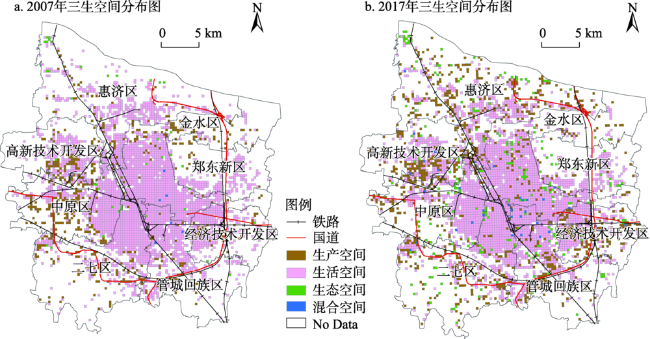
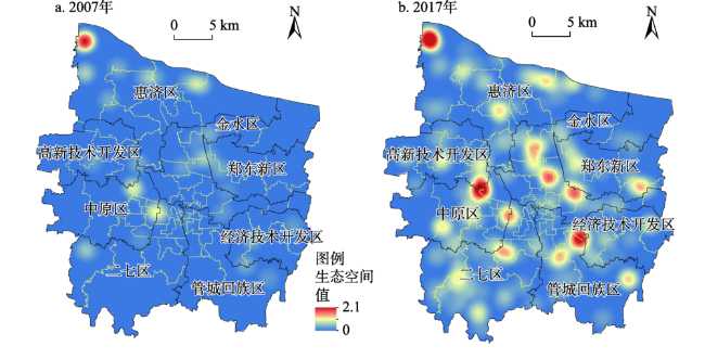
Based on the POI data of Zhengzhou city in 2007 and 2017, the “production-living-ecological” spaces within the city was identified by using random forest model and quadrat proportion method, and the spatial-temporal evolution of “production-living-ecological” spaces in the study area was examined by using nuclear density and other methods. The results show that: First, as a new machine learning algorithm, random forest model can identify “production-living-ecological” spaces with high accuracy. Second, the spatial distribution pattern of “production-living-ecological” spaces in Zhengzhou matched with the urban functional zoning. The production space was concentrated in the industrial agglomeration area, the living space was located in the central urban area with a plane shape, and the ecological space was distributed in a scatter pattern as a whole. Finally, with the development of urbanization and the improvement of infrastructure in Zhengzhou, the spatial distribution pattern of “production-living-ecological” spaces in the city was more reasonable in the past 10 years. The production space was concentrated in the industrial agglomeration area, the living space was gradually dispersed, and the ecological spatial distribution was more balanced. Based on POI data, the method of random forest model to identify “production-living-ecological” spaces within the city was more effective, and the recognition results were more accurate, which can provide data and method support for territorial spatial planning on a smaller scale.
ZHAO Hongbo , WEI Jiachen , SUN Dongqi , LIU Yaxin , WANG Shuang , TAN Juntao , MIAO Changhong . Recognition and spatio-temporal evolution analysis of production-living-ecological spaces based on the random forest model: A case study of Zhengzhou city, China[J]. GEOGRAPHICAL RESEARCH, 2021 , 40(4) : 945 -957 . DOI: 10.11821/dlyj020200237
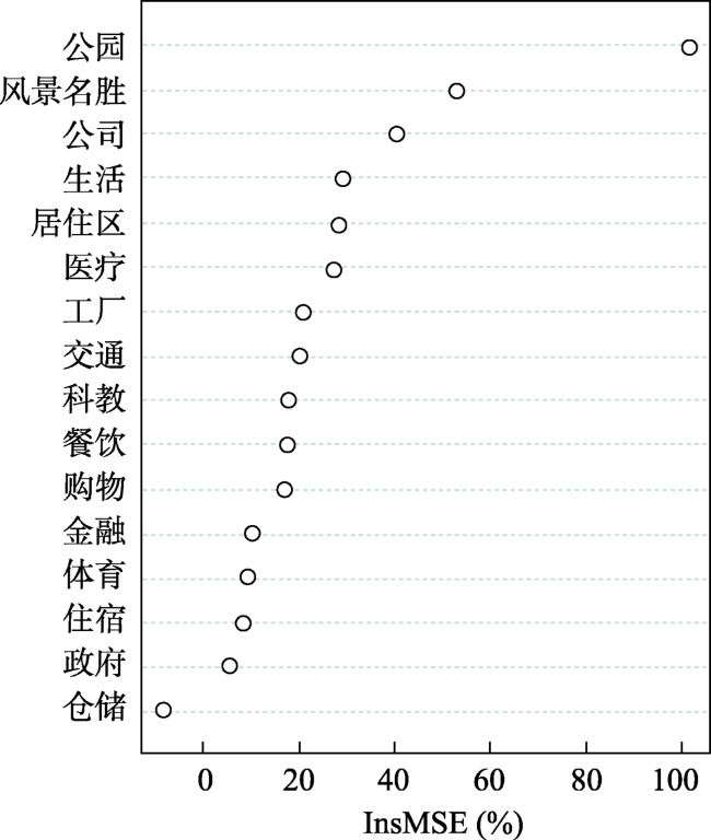
表1 基于“三生空间”的POI分类表Tab. 1 POI classification based on production-living-ecological spaces |
| 三生空间 | 大类 | 种类 | 主要用地类型 |
|---|---|---|---|
| 生产 | 生产性服 务业空间 | 公司企业 | 工业用地+商服用地 |
| 金融保险 | 商务设施用地 | ||
| 工业空间 | 工厂及产业园 | 工业用地 | |
| 仓储物流 | 物流仓储用地 | ||
| 管理空间 | 政府机构 | 行政办公用地 | |
| 交通空间 | 交通设施 | 道路与交通设施用地 | |
| 生活 | 生活性服务业空间 | 餐饮服务 | 商服用地+住宅用地 |
| 购物服务 | 商业设施用地 | ||
| 生活服务 | 服务设施用地 | ||
| 医疗保健 | 医疗卫生用地 | ||
| 科教文化 | 教育科研用地 | ||
| 体育休闲 | 体育用地 | ||
| 住宿服务 | 旅馆用地 | ||
| 居住空间 | 居住区 | 住宅用地 | |
| 生态 | 绿地空间 | 公园广场 | 公园绿地+广场用地 |
| 风景名胜 | 风景名胜设施用地 |
注:用地类型参照《城市用地分类与规划建设用地标准(GB50137-2011)》[23]。 |
表2 不同尺度下随机森林模型预测准确率Tab. 2 The forecast accuracy of random forests at different scales |
| 空间类型 | 生产空间 | 生活空间 | 生态空间 | 总量 | ||||
|---|---|---|---|---|---|---|---|---|
| 格网大小(m) | 300 | 500 | 300 | 500 | 300 | 500 | 300 | 500 |
| 样本数量(个) | 138 | 39 | 147 | 97 | 104 | 63 | 389 | 199 |
| 预测数量(个) | 123 | 31 | 139 | 92 | 101 | 55 | 363 | 178 |
| 准确率(%) | 89.13 | 79.49 | 94.56 | 94.85 | 97.12 | 87.30 | 93.32 | 89.45 |
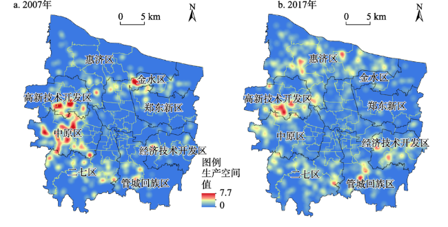
图3 2007年与2017年郑州市生产空间核密度图Fig. 3 Kernel density analysis of production space in Zhengzhou city in 2007 and 2017 |
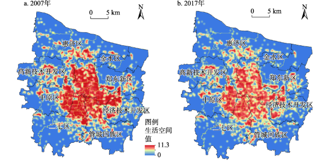
图4 2007年与2017年郑州市生活空间核密度图Fig. 4 Kernel density analysis of living space in Zhengzhou city in 2007 and 2017 |
表4 2007年与2017年“三生空间”Moran's I指数Tab. 4 The Moran’s I of “production-living-ecological spaces” in 2007 and 2017 |
| 2007年 | 2017年 | ||||||
|---|---|---|---|---|---|---|---|
| 生产空间 | 生活空间 | 生态空间 | 生产空间 | 生活空间 | 生态空间 | ||
| Moran's I | 0.097 | 0.137 | 0.219 | 0.205 | 0.129 | 0.160 | |
| Z得分 | 7.367 | 19.996 | 1.728 | 16.491 | 13.957 | 4.970 | |
| P值 | 0.000 | 0.000 | 0.084 | 0.000 | 0.000 | 0.000 | |
表5 2007年与2017年郑州市各市辖区“三生空间”的变化Tab. 5 The changes of “production-living-ecological spaces” in different districts of Zhengzhou city in 2007 and 2017 |
| 金水区 | 二七区 | 管城回族区 | 惠济区 | 中原区 | 郑东新区 | 高新区 | 经开区 | |
|---|---|---|---|---|---|---|---|---|
| 生产空间2007年 | 81 | 99 | 47 | 54 | 150 | 23 | 87 | 36 |
| 生产空间2017年 | 86 | 157 | 105 | 281 | 100 | 20 | 132 | 110 |
| 生活空间2007年 | 814 | 504 | 458 | 438 | 423 | 190 | 220 | 253 |
| 生活空间2017年 | 754 | 466 | 426 | 365 | 417 | 183 | 194 | 224 |
| 生态空间2007年 | 6 | 1 | 2 | 16 | 8 | 2 | 2 | 3 |
| 生态空间2017年 | 42 | 40 | 28 | 51 | 30 | 19 | 19 | 11 |
注:“高新区”指高新技术开发区;“经开区”指经济技术开发区。 |
真诚感谢匿名评审专家在论文题目凝练、“三生空间”识别准确性验证、文章逻辑与思路、结果分析、结论梳理所付出的时间和精力,使本文获益匪浅。
| [1] |
汪芳, 安黎哲, 党安荣, 等. 黄河流域人地耦合与可持续人居环境. 地理研究, 2020,39(8):1707-1724.
[
|
| [2] |
刘继来, 刘彦随, 李裕瑞. 中国“三生空间”分类评价与时空格局分析. 地理学报, 2017,72(7):1290-1304.
[
|
| [3] |
李欣, 殷如梦, 方斌, 等. 基于“三生”功能的江苏省国土空间特征及分区调控. 长江流域资源与环境, 2019,28(8):1833-1846.
[
|
| [4] |
陈仙春, 赵俊三, 陈国平. 基于“三生空间”的滇中城市群土地利用空间结构多尺度分析. 水土保持研究, 2019,26(5):258-264.
[
|
| [5] |
马晓冬, 李鑫, 胡睿, 等. 基于乡村多功能评价的城市边缘区“三生”空间划分研究. 地理科学进展, 2019,38(9):1382-1392.
[
|
| [6] |
赵旭, 汤峰, 张蓬涛, 等. 基于CLUE-S模型的县域生产-生活-生态空间冲突动态模拟及特征分析. 生态学报, 2019,39(16):5897-5908.
[
|
| [7] |
李广东, 方创琳. 城市生态-生产-生活空间功能定量识别与分析. 地理学报, 2016,71(1):49-65.
[
|
| [8] |
黄金川, 林浩曦, 漆潇潇. 面向国土空间优化的“三生空间”研究进展. 地理科学进展, 2017,36(3):378-391.
[
|
| [9] |
柳冬青, 马学成, 巩杰, 等. 流域“三生空间”功能识别及时空格局分析: 以甘肃白龙江流域为例. 生态学杂志, 2018,37(5):1490-1497.
[
|
| [10] |
程婷, 赵荣, 梁勇. 国土“三生空间”分类及其功能评价. 遥感信息, 2018,33(2):114-121.
[
|
| [11] |
刘春芳, 王奕璇, 何瑞东, 等. 基于居民行为的“三生空间”识别与优化分析框架. 自然资源学报, 2019,34(10):2113-2122.
[
|
| [12] |
池娇, 焦利民, 董婷, 等. 基于POI数据的城市功能区定量识别及其可视化. 测绘地理信息, 2016,41(2):68-73.
[
|
| [13] |
许泽宁, 高晓路. 基于电子地图兴趣点的城市建成区边界识别方法. 地理学报, 2016,71(6):928-939.
[
|
| [14] |
曹根榕, 顾朝林, 张乔扬. 基于POI数据的中心城区三生空间识别及格局分析: 以上海市中心城区为例. 城市规划学刊, 2019, (2):44-53.
[
|
| [15] |
张雷, 王琳琳, 张旭东, 等. 随机森林算法基本思想及其在生态学中的应用: 以云南松分布模拟为例. 生态学报, 2014,34(3):650-659.
[
|
| [16] |
项涛, 董响红, 郭超, 等. 基于随机森林模型预测气候变化对黄颡鱼适生区的影响. 水生生物学报, 2019,43(6):1262-1270.
[
|
| [17] |
赵彦锋, 程道全, 巫振富, 等. 基于空间分析的河南省小麦施肥问题诊断与地理优化. 土壤学报, 2020,57(5):1206-1218.
[
|
| [18] |
王超, 阚瑷珂, 曾业隆, 等. 基于随机森林模型的西藏人口分布格局及影响因素. 地理学报, 2019,74(4):664-680.
[
|
| [19] |
|
| [20] |
赵鹏军, 曹毓书. 基于多源地理大数据与机器学习的地铁乘客出行目的识别方法. 地球信息科学学报, 2020,22(9):1753-1765.
[
|
| [21] |
蒲东川, 王桂周, 张兆明, 等. 基于独立成分分析和随机森林算法的城镇用地提取研究. 地球信息科学学报, 2020,22(8):1597-1606.
[
|
| [22] |
赵宏波, 余涤非, 苗长虹, 等. 基于POI数据的郑州市文化设施的区位布局特征与影响因素研究. 地理科学, 2018,38(9):1525-1534.
[
|
| [23] |
中华人民共和国住房和城乡建设部. 城市用地分类与规划建设用地标准(GB50137-2011), 北京: 中国建筑工业出版社, 2011.
[ Ministry of Housing and Urban-Rural Development of the People's Republic of China. Code for classification of urban land use and planning standards of development land (GB50137-2011). Beijing: China Architecture & Building Press, 2011].
|
| [24] |
金宇, 周可新, 高吉喜, 等. 基于随机森林模型的国家重点保护陆生脊椎动物物种优先保护区的识别. 生态学报, 2016,36(23):7702-7712.
[
|
| [25] |
方匡南, 吴见彬, 朱建平, 等. 随机森林方法研究综述. 统计与信息论坛, 2011,26(3):32-38.
[
|
| [26] |
|
| [27] |
|
| [28] |
王劲峰. 空间分析. 北京: 科学出版社, 2006: 76-84.
[
|
| [29] |
|
| [30] |
康雨豪, 王玥瑶, 夏竹君, 等. 利用POI数据的武汉城市功能区划分与识别. 测绘地理信息, 2018,43(1):81-85.
[
|
/
| 〈 |
|
〉 |