
Study on water resources zoning of five countries in Indo-China Peninsula
Received date: 2020-05-11
Accepted date: 2020-07-13
Online published: 2021-07-10
Copyright
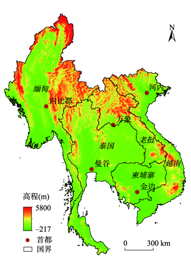
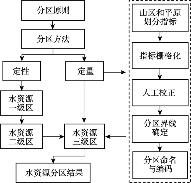
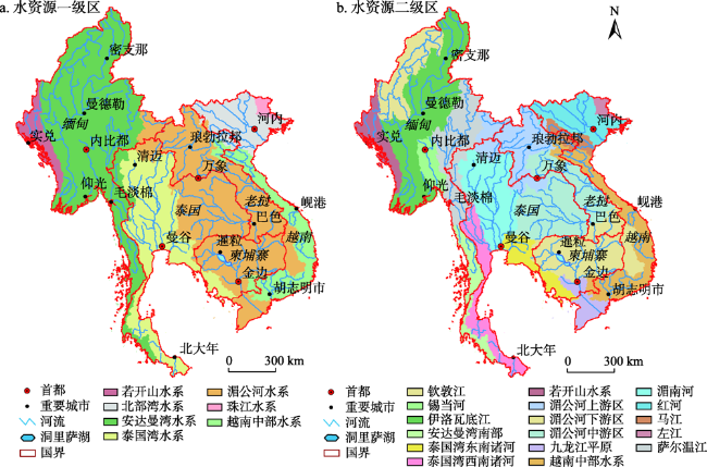
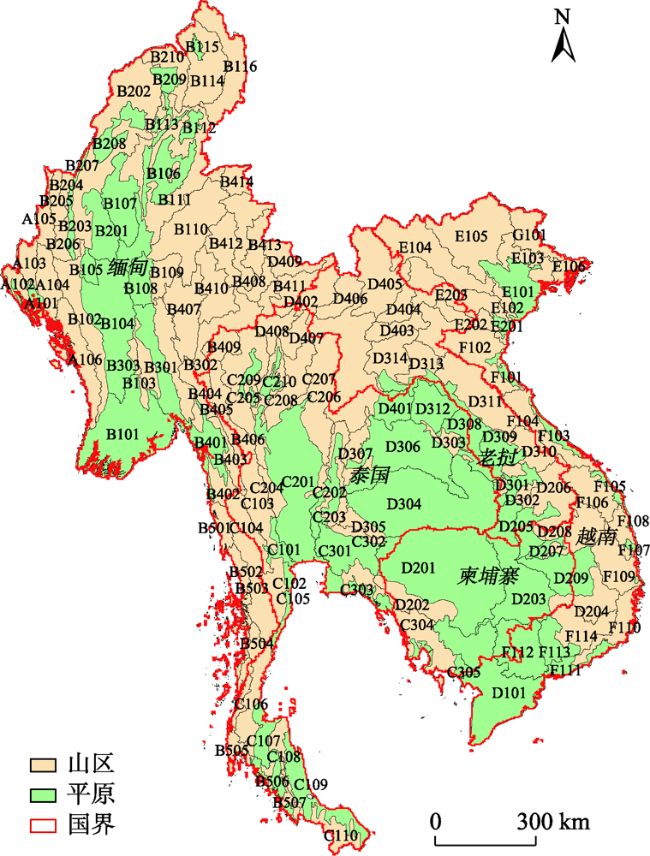
Indo-China Peninsula, located in the southeast tip of the Eurasian continent, is one of the three major peninsulas in southern Asia. Five countries in the Indo-China Peninsula in this article refer to Myanmar, Thailand, Laos, Cambodia, and Vietnam, lying between 92°0'-109°30' east longitude and 5°30'-28°30' north latitude. The region is adjacent to the Andaman Sea to the west, Malay Peninsula to the south, South China Sea to the east and Chinese mainland to the north, covering a total land area of about 1938700 km2. Under the background of global change and the Belt and Road Initiative, the characteristics of water resources in the Indo-China Peninsula and different scenarios of socio-economic development in the future have aroused great concern. However, there have been relatively few systematic studies on water resources in this region, thus there are urgent needs to carry out related work. Through combing and summarizing previous studies, we used the GIS-based watershed topography division method to partition the water resources in the Indo-China Peninsula. The three-level divisions of water resources took into account the distribution of river systems and topographical factors, which reflected the characteristics of water resources in the five countries. The results illustrated that the water resources area of the peninsula can be divided into 7 first-level water resources zones, 17 second-level water resources zones and 138 third-level water resources zones. Seven first-level water resources zones were international basins, and the basin management of the peninsula needs cooperation and overall planning of all the countries. There were 87 mountainous units in the three-level water resources zones, with an area of about 1154120 km2, accounting for 60% of the total land area. There were 51 plain units with an area of about 779150 km2, accounting for 40% of the total land area. The ratio of mountainous area to plain area is 1.48, the mountainous area units were mainly concentrated in the middle and upper reaches of the basin, while the plain units were mainly concentrated in the lower reaches of the basin and coastal areas. The results will serve the evaluation and utilization of water resources in the five countries of the Indo-China Peninsula, and provide an effective reference for scientific regulation and benefit sharing of international rivers in this region.
QIU Tao , ZHANG Shifeng , XIAN Wen . Study on water resources zoning of five countries in Indo-China Peninsula[J]. GEOGRAPHICAL RESEARCH, 2021 , 40(5) : 1421 -1431 . DOI: 10.11821/dlyj020200402
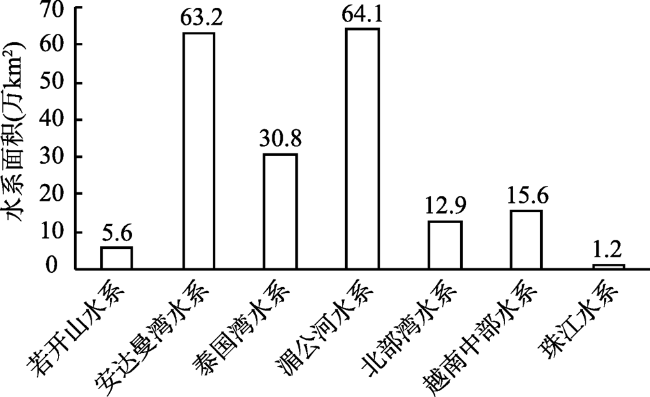
表1 中南半岛水资源二级分区成果Tab. 1 Results of the second level water resources zones in the Indo-China Peninsula |
| 一级区名称 | 二级区名称 | 分布区域 | 三级区个数 |
|---|---|---|---|
| 若开山水系(A) | 若开山水系(A1) | 缅甸 | 6 |
| 安达曼湾水系(B) | 伊洛瓦底江(B1) | 缅甸 | 16 |
| 钦敦江(B2) | 缅甸 | 10 | |
| 锡当河(B3) | 缅甸 | 3 | |
| 萨尔温江(B4) | 缅甸 泰国 | 14 | |
| 安达曼湾南部(B5) | 缅甸 泰国 | 7 | |
| 泰国湾水系(C) | 泰国湾西南诸河(C1) | 泰国 | 10 |
| 湄南河(C2) | 泰国 老挝 缅甸 | 10 | |
| 泰国湾东南诸河(C3) | 泰国 柬埔寨 | 5 | |
| 湄公河水系(D) | 九龙江平原(D1) | 越南 柬埔寨 | 1 |
| 湄公河下游区(D2) | 老挝 柬埔寨 越南 | 9 | |
| 湄公河中游区(D3) | 泰国 老挝 | 14 | |
| 湄公河上游区(D4) | 缅甸 老挝 泰国 | 9 | |
| 北部湾水系(E) | 红河(E1) | 越南 老挝 | 6 |
| 马江(E2) | 越南 老挝 | 3 | |
| 越南中部水系(F) | 越南中部水系(F1) | 越南 | 14 |
| 珠江水系(G) | 左江(G1) | 越南 | 1 |
表2 中南半岛水资源三级分区成果Tab. 2 Results of the third level water resources zones in Indo-China Peninsula |
| 二级区 | 三级区 | 个数 |
|---|---|---|
| A1 | 若开北部平原(01) 若开北部山区(02) 加拉丹河山区(03) 莱谬河山区(04) 博伊努河山区(05) 若开南部山区(06) | 6 |
| B1 | 伊洛瓦底江三角洲平原(01) 伊洛瓦底江下游山区(02) 勃固山西部山区(03) 伊洛瓦底江下游平原(04) 尧河平原(05) 伊洛瓦底江上游平原(06) 穆河平原(07) 照济河平原(08) 照济河山区(09) 南渡河山区(10) 伊洛瓦江上游山区(11) 密支那平原(12) 莫冈河平原(13) 迈立开江山区(14) 葡萄平原(15) 恩梅开江山区(16) | 16 |
| B2 | 钦敦江下游平原(01) 钦敦江山区(02) 密达河平原(03) 莱达岭山区(04) 曼尼普尔河山区(05) 密达河山区(06) 玉河平原(07) 钦敦江上游平原(08) 塔奈河平原(09) 塔奈河山区(10) | 10 |
| B3 | 锡当河平原(01) 锡当河山区(02) 勃固山东部山区(03) | 3 |
| B4 | 萨尔温江平原(01) 扎米河山区(02) 坚河山区(03) 萨尔温江下游山区(04) 延河山区(05) 当翁河山区(06) 南蚌河山区(07) 萨尔温江上游山区(08) 拜河山区(09) 南登河山区(10) 辛河山区(11) 南庞河山区(12) 南卡江山区(13) 莱别山东部山区(14) | 14 |
| B5 | 土瓦河山区(01) 德林达依沿海山区(02) 德林达依河山区(03) 莱尼亚河山区(04) 安达曼湾东南山区(05) 安达曼湾南部平原(06) 安达曼湾南部山区(07) | 7 |
| C1 | 桂河平原(01) 比劳山东南山区(02) 桂河山区(03) 奎内河山区(04) 泰国湾西北平原(05) 泰国湾西部山区(06) 泰国湾西部平原(07) 泰国湾西南山区(08) 泰国湾西南平原(09) 泰国湾南部山区(10) | 10 |
| C2 | 湄南河平原(01) 巴塞河平原(02) 巴塞河山区(03) 湄南河下游山区(04) 宾河山区(05) 难河山区(06) 永河山区(07) 旺河山区(08) 宾河平原(09) 旺河平原(10) | 10 |
| C3 | 班巴功河平原(01) 班巴功河山区(02) 泰国湾东北部平原(03) 泰国湾东部山区(04) 泰国湾东南平原(05) | 5 |
| D1 | 九龙江平原(01) | 1 |
| D2 | 洞里萨平原(01) 洞里萨山区(02) 湄公河下游平原(03) 湄公河下游山区(04) 公河平原(05) 公河山区(06) 桑河平原(07) 桑河山区(08) 斯雷博河平原(09) | 9 |
| D3 | 色敦河平原(01) 色敦河山区(02) 湄公河中游山区(03) 蒙河平原(04) 蒙河山区(05) 锡河平原(06) 锡河山区(07) 湄公河中游平原(08) 色邦亨河平原(09) 色邦亨河山区(10) 长山北部山区(11) 颂堪河平原(12) 川圹高原东南山区(13) 南俄河山区(14) | 14 |
| D4 | 湄公河上游平原(01) 湄公河上游山区(02) 南康河山区(03) 南森河山区(04) 南乌江山区(05) 南塔河山区(06) 英河山区(07) 科克河山区(08) 南莱河山区(09) | 9 |
| E1 | 红河平原(01) 红河下游山区(02) 太平江山区(03) 沱江山区(04) 红河山区(05) 广宁山区(06) | 6 |
| E2 | 马江平原(01) 朱江山区(02) 马江山区(03) | 3 |
| F1 | 大江平原(01) 大江山区(02) 越南中北部平原(03) 越南中北部山区(04) 武嘉河-秋盆河平原(05) 武嘉河-秋盆河山区(06) 越南中南平原(07) 越南中南山区(08) 巴江山区(09) 长山东南山区(10) 越南东南平原(11) 西贡河平原(12) 同奈河平原(13) 同奈河山区(14) | 14 |
| G1 | 左江山区(01) | 1 |
图3 水资源一级区和二级区示意注: 该图基于国家自然资源部标准地图服务系统的标准地图(审图号:GS(2016)1663号)制作,底图无修改。 Fig. 3 Schematic diagram of the first and second level water resources zones |
匿名评审专家提出的意见和建议对本文的行文安排、数据和图表内容的改进、划分方法检验、结论梳理等方面有很大的帮助,特此感谢。
| [1] |
马颖忆, 陆玉麒, 柯文前, 等. 泛亚高铁建设对中国西南边疆地区与中南半岛空间联系的影响. 地理研究, 2015,34(5):825-837.
[
|
| [2] |
何大明, 刘昌明, 杨志峰. 中国国际河流可持续发展研究. 地理学报, 1999,66(S1):1-10.
[
|
| [3] |
冯彦, 何大明. 国际河流水电合作开发投资-效益分配模式及特征. 地理研究, 2014,33(10):1807-1816.
[
|
| [4] |
陈丽晖, 何大明. 澜沧江-湄公河水电梯级开发的生态影响. 地理学报, 2000,67(5):577-586.
[
|
| [5] |
洪菊花, 骆华松. 中国与东南亚地缘环境和跨境河流合作. 世界地理研究, 2015,24(1):29-37.
[
|
| [6] |
何大明, 刘恒, 冯彦, 等. 全球变化下跨境水资源理论与方法研究展望. 水科学进展, 2016,27(6):928-934.
[
|
| [7] |
|
| [8] |
|
| [9] |
|
| [10] |
|
| [11] |
|
| [12] |
王浩, 王建华. 中国水资源与可持续发展. 中国科学院院刊, 2012,27(3):352-358, 331.
[
|
| [13] |
|
| [14] |
|
| [15] |
杨艳昭, 封志明, 孙通, 等. “一带一路”沿线国家水资源禀赋及开发利用分析. 自然资源学报, 2019,34(6):1146-1156.
[
19-06-002.
|
| [16] |
孙周亮, 刘艳丽, 刘冀, 等. 澜沧江-湄公河流域水资源利用现状与需求分析. 水资源与水工程学报, 2018,29(4):67-73.
[
|
| [17] |
|
| [18] |
屈飞强. 澜湄合作中的水资源合作研究. 济南: 山东大学硕士学位论文, 2018: 4-6.
[
|
| [19] |
|
| [20] |
王志刚, 黄超君. “一带一路”背景下老挝水资源的现状、问题与对策. 世界农业, 2018,40(11):196-201, 271.
[
|
| [21] |
朴光姬, 李芳. “一带一路”对接缅甸水资源开发新思路研究. 南亚研究, 2017,37(4):60-77, 153.
[
|
| [22] |
朱陆民, 陈丽斌. 地缘战略角度思考中国与中南半岛合作的重要意义. 世界地理研究, 2011,20(2):20-28.
[
|
| [23] |
赵萍, 汤洁, 尹笋. 湄公河流域水资源开发利用现状. 水利经济, 2017,35(4): 55-58,77-78.
[
|
| [24] |
道比. 东南亚. 北京: 商务印书馆, 1959: 126-129.
[
|
| [25] |
任美锷. 东南亚地理. 北京: 中国青年出版社, 1954: 11-13.
[
|
| [26] |
|
| [27] |
|
| [28] |
全球行政区划数据库 (GADM). https://gadm.org/download_country_v3.html, 2019-09-27.
[ Database of Global Administrative Areas. https://gadm.org/download_country_v3.html, 2019-09-27. ]
|
| [29] |
郝林钢. “一带一路”分区自然地理特征及水资源分析. 郑州: 郑州大学硕士学位论文, 2019: 12-13.
[
|
| [30] |
左其亭, 韩春辉, 郝林钢, 等. “一带一路”主体路线及主体水资源区研究. 资源科学, 2018,40(5):1006-1015.
[
|
| [31] |
张伟, 李爱农, 江晓波. 基于DEM的中国山地空间范围定量界定. 地理与地理信息科学, 2013,29(5):58-63.
[
|
| [32] |
南希, 李爱农, 陈昱, 等. 竖版中国数字山地图(1∶670万)的设计与编制. 遥感技术与应用, 2016,31(3):451-458.
[
|
| [33] |
李妍清, 王含, 陕硕, 等. 柬埔寨水资源量时空分布研究. 人民长江, 2018,49(22):33-39.
[
|
/
| 〈 |
|
〉 |