
The characteristics and changing trend of administrative boundary above county level in China
Received date: 2020-09-27
Accepted date: 2020-12-16
Online published: 2021-11-10
Copyright
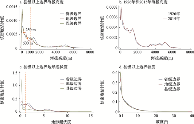
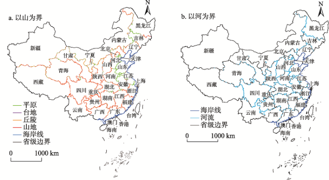
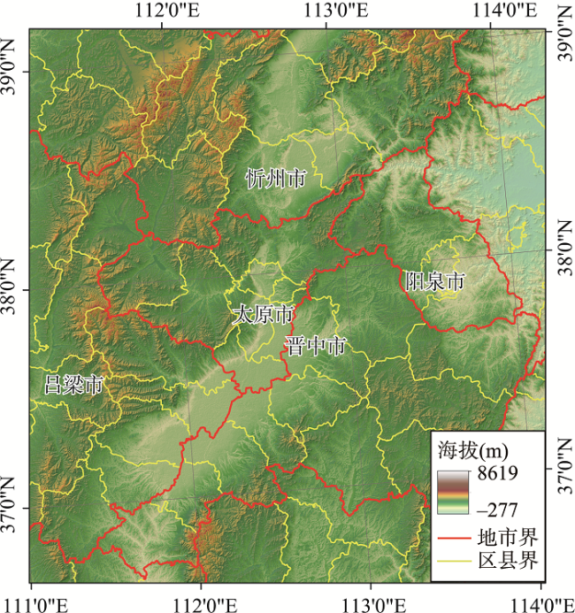
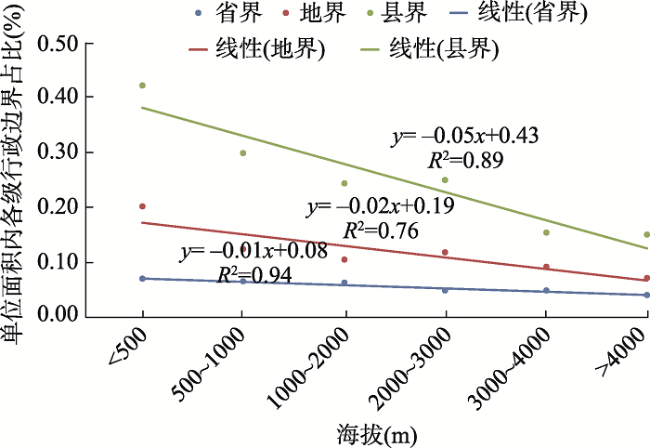
As one of the basic elements of administrative division, administrative boundary is the spatial basis and important basis for the country to implement effective administrative management according to law. This study uses spatial analysis, multiple regression analysis based on grid and other methods to study the administrative boundaries above the county level in China and their changing trend. The results show that: at present, China is still divided into geographical regions and administrative regions according to the natural geographical features such as mountains and rivers. The administrative boundaries were zigzag, as jagged as a dog's teeth. On the whole, the higher the administrative level is, the more obviously it is affected by the principle of the shape of mountains and rivers, the lower the altitude is, and the more obviously affected by the principle of the interlacing of administrative boundaries. The existing ways of dividing administrative boundaries are mainly reflected in the following aspects: first, ecological division frequently occurs, which has negative effect on the overall protection of the ecological environment in the border areas. Problems existing in the current administrative region boundary segmentation approach are mainly reflected in the following aspects. The demarcation principle of convenient mountains and rivers in administrative areas is prone to cause some complete ecological environment units to be divided artificially by different administrative boundaries, which can lead to a variety of inter-regional contradictions, which has negative effect on the overall protection of the ecological environment in border areas. In addition, uneven administrative boundaries undermine the integrity of the economic zone, raise the circulation costs and administrative costs of production factors, which is likely to lead to boundary disputes and interest disputes. At present, the impact of mountains and rivers on the national economic and social development is weakening, and the economic and social development is gradually breaking through the restrictions of administrative boundaries. In the process of administrative division adjustment in the future, administrative boundaries should be set by crossing mountains and rivers in a timely manner, and the way of administrative district setting should be changed, so as to ensure the integrity of ecological environment and the actual needs of economic and social development.
ZHAO Biao , WANG Kaiyong , WANG Fuyuan , LIU Haimeng . The characteristics and changing trend of administrative boundary above county level in China[J]. GEOGRAPHICAL RESEARCH, 2021 , 40(9) : 2494 -2507 . DOI: 10.11821/dlyj020200933
表1 计量模型估计结果Tab. 1 Estimate results of measurement model |
| 变量 | 全样本 | 东部 | 中西部 | |||||
|---|---|---|---|---|---|---|---|---|
| 2000年 | 2015年 | 2000年 | 2015年 | 2000年 | 2015年 | |||
| lnlucc | 0.549*** (135.67) | 0.642*** (156.01) | 0.192*** (26.44) | 0.285*** (31.45) | 0.673*** (134.00) | 0.757*** (137.92) | ||
| lnpop | 0.168*** (128.26) | 0.318*** (123.76) | 0.526*** (74.43) | 0.626*** (60.54) | 0.148*** (112.99) | 0.224*** (97.16) | ||
| lndem | -0.538*** (-176.85) | -0.591*** (-146.37) | -0.526*** (-72.21) | -0.607*** (-76.44) | -0.422*** (-115.44) | -0.439*** (-92.86) | ||
| lndis_river | -0.028*** (-9.09) | -0.034*** (-9.51) | -0.058*** (-6.00) | -0.031** (-5.34) | -0.054*** (-17.33) | -0.063*** (-13.54) | ||
| lndis_sheng | 0.001 (-0.52) | -0.034*** (-9.76) | 0.114*** (12.25) | 0.137*** (14.93) | 0.001 (0.39) | -0.027*** (-8.34) | ||
| lndis_shi | -0.016*** (-5.20) | -0.006 (-1.75) | 0.001 (0.06) | 0.141*** (11.43) | -0.018*** (-5.68) | -0.018*** (-3.70) | ||
| lndis_xian | -0.027*** (-8.68) | -0.001 (-1.07) | -0.084*** (-8.02) | 0.032** (2.20) | -0.016*** (-5.14) | -0.001 (-0.02) | ||
| Constant | 4.712*** (72.22) | 4.268*** (46.27) | 1.757*** (8.16) | -0.826*** (-3.44) | 4.074*** (61.46) | 4.248*** (37.44) | ||
| N | 152695 | 152695 | 17605 | 17605 | 137624 | 137624 | ||
| R2 | 0.552 | 0.549 | 0.562 | 0.561 | 0.444 | 0.480 | ||
| F | 26848 | 24294 | 3222 | 2623 | 15673 | 14640 | ||
注:括号中数据是t统计量;***、**分别表示在1%、5%的统计学意义上显著。 |
真诚感谢匿名评审专家和编辑老师在论文评审中所付出的时间和精力,各位老师对本文的文献回顾、图形表达、边界效应指标选取等方面的修改意见,使本文获益匪浅。
| [1] |
周振鹤. 中国行政区划通史. 上海: 复旦大学出版社, 2009: 15.
[
|
| [2] |
周振鹤. 体国经野之道: 中国行政区划沿革. 上海: 上海书店出版社, 2009.
[
|
| [3] |
徐建平. 民国时期鄂皖赣三省沿江边界调整与江堤维护. 史林, 2009, (4):9-20, 189.
[
|
| [4] |
王爱民, 刘宇, 缪磊磊. 少数民族地区行政边界纠纷的诱因和对策探讨: 以甘青农牧交错带为例. 干旱区资源与环境, 2002, 16(4):19-23.
[
|
| [5] |
周黎安, 陶婧. 官员晋升竞争与边界效应: 以省区交界地带的经济发展为例. 金融研究, 2011, (3):15-26.
[
|
| [6] |
张崇旺. 淮河流域水生态环境变迁与水事纠纷研究(1127-1949). 天津: 天津古籍出版社, 2015: 255-256.
[
|
| [7] |
杨斌. 插花地研究: 以明清以来贵州与四川、重庆交界地区为例. 北京: 中国社会科学出版社, 2015: 356-357.
[
|
| [8] |
王颖, 陆玉麒. 中国省界线形成的地理背景. 南京师大学报(自然科学版), 2003, 26(1):116-120.
[
|
| [9] |
侯甬坚. 从习惯线到法定线: 我国政区界线性质的变迁. 江汉论坛, 2006, (1):81-85.
[
|
| [10] |
徐建平. 中国近现代行政区域划界研究. 上海: 复旦大学出版社, 2020: 2-3.
[
|
| [11] |
胡英泽. 河道变动与界的表达: 以清代至民国的山、陕滩案为中心. 中国社会历史评论, 2006, 7(0):199-220.
[
|
| [12] |
徐建平. 从界限到界线: 湖滩开发与省界成型: 以丹阳湖为例. 史林, 2008, (3):119-136, 191.
[
|
| [13] |
施剑. 清代浙江省政区边界的格局构建与空间类型研究. 浙江师范大学学报 (社会科学版), 2016, 41(3):33-43.
[
|
| [14] |
杨学新, 宰波. 新中国政区边界水利纠纷治理的实践与历史启示: 以冀豫两省漳河堤防归属纠纷为中心的考察. 学术探索, 2018, (10):41-46.
[
|
| [15] |
A N斯皮里顿诺夫. 地貌制图学. 北京: 地质出版社, 1956: 5-8.
[
|
| [16] |
王利, 王慧鹏, 任启龙, 等. 关于基准地形起伏度的设定和计算: 以大连旅顺口区为例. 山地学报, 2014, 32(3):277-283.
[
|
| [17] |
封志明, 张丹, 杨艳昭. 中国分县地形起伏度及其与人口分布和经济发展的相关性. 吉林大学社会科学学报, 2011, 51(1):146-151,160.
[
|
| [18] |
刘锐, 胡伟平, 王红亮, 等. 基于核密度估计的广佛都市区路网演变分析. 地理科学, 2011, 31(1):81-86.
[
|
| [19] |
刘靖, 张车伟, 毛学峰. 中国1991-2006年收入分布的动态变化: 基于核密度函数的分解分析. 世界经济, 2009, 32(10):3-13.
[
|
| [20] |
赵彪. 1954年以来中国县级行政区划特征演变. 经济地理, 2018, 38(2):10-17.
[
|
| [21] |
( 宋) 郑樵. 通志·地理略. 杭州: 浙江古籍出版社, 1988: 218-219.
[(
|
| [22] |
杨春侠. 城市跨河形态与设计. 南京: 东南大学出版社, 2014: 1-5.
[
|
| [23] |
吴金群. 基于省管县改革的行政区划调整. 中共浙江省委党校学报, 2013, 29(5):92-98.
[
|
| [24] |
冯俏彬, 安森东, 水名岳, 等. 新型城镇化进程中的行政层级与行政区划改革研究. 北京: 商务印书馆, 2015: 52-58.
[
|
| [25] |
浦善新. 中国行政区划改革研究. 北京.商务印书馆, 2006: 153-157.
[
|
| [26] |
卢中辉, 毛广雄, 尚正永, 等. 长江中游城市群省级行政边界效应的测度. 统计与决策, 2018, 34(17):121-125.
[
|
| [27] |
李静, 陶璐, 杨娜. 淮河流域污染的“行政边界效应”与新环境政策影响. 中国软科学, 2015, (6):91-102.
[
|
| [28] |
崔兆财, 周向红. 中国省级行政边界处的非连续增长: 基于 DMSP/OLS 夜间灯光数据的实证研究. 经济问题探索, 2018, (4):9-17.
[
|
| [29] |
唐为. 分权、外部性与边界效应. 经济研究, 2019, 54(3):103-118.
[
|
/
| 〈 |
|
〉 |