
Study on flow resilience of air traffic in Beijing-Guangzhou Corridor: A comparison between original network and optimized network
Received date: 2023-12-11
Accepted date: 2024-06-06
Online published: 2024-10-14
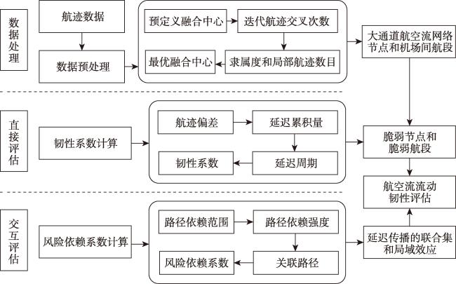
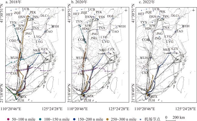
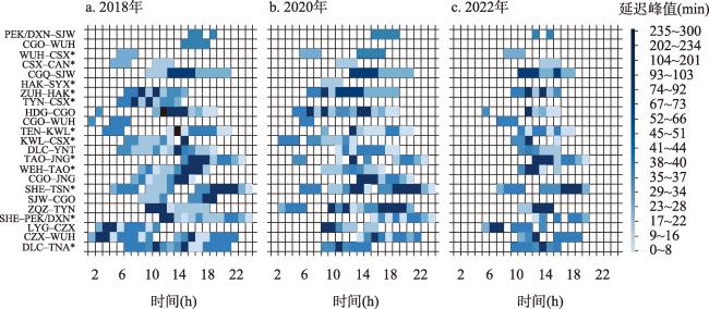
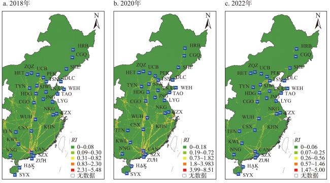
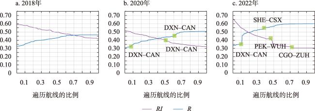
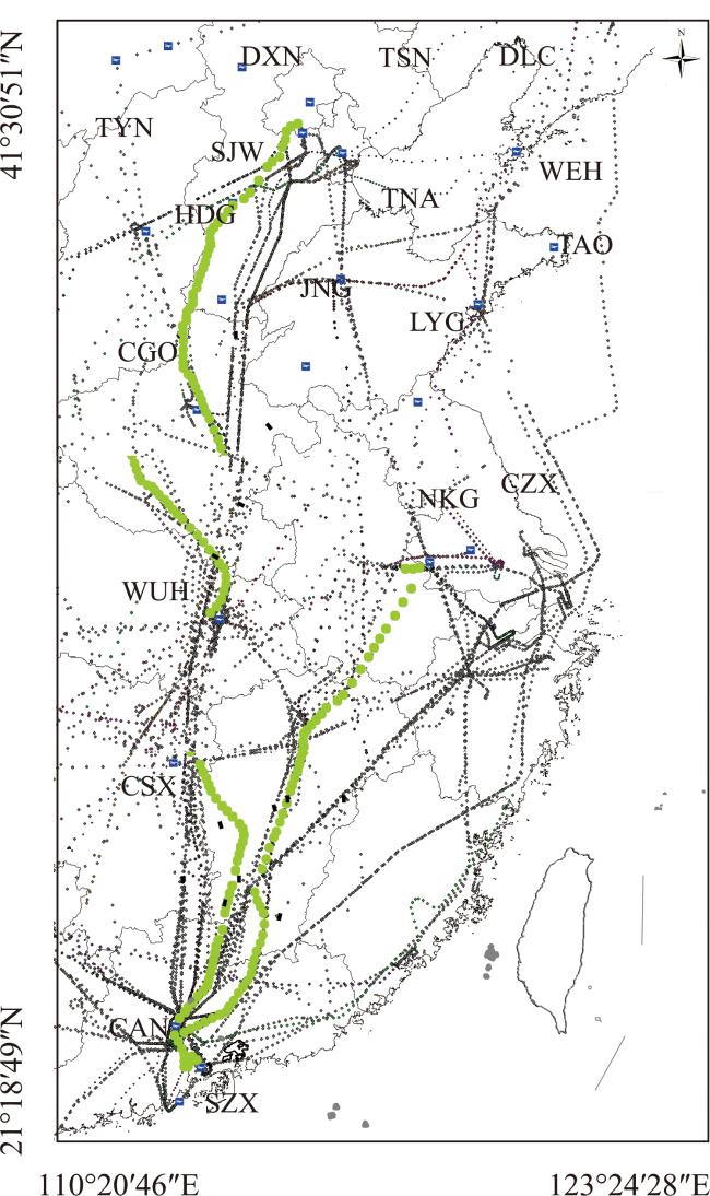
The Beijing-Guangzhou Corridor is an important project in China's 13th Five-Year Civil Aviation Plan (2016-2020), which aims to adjust the airspace structure and release the airspace carrying capacity on a macro scale, and it is expected to improve the resilience of air traffic flow. In this paper, a combined evaluation framework of air traffic flow resilience is constructed to analyze the changes of air traffic resilience before and after the opening of the Beijing-Guangzhou Corridor by using delay data of track, and then reveal its internal mechanism. Comparing the original network with the optimized network, we found that the vulnerable nodes and segments were transferred from the central airport and its associated segments along the route to the peripheral participating airports and associated segments. In the optimized network, the number and scope of delay propagation dependent paths were reduced and the delay propagation dependent chain was loosened. The spatial structure of delay dependence risk tended to be multi-source network mode, which reduced the polarization state of aviation flow network and enhanced the balance. The original “axial belt” model of the delay risk of the central airport along the route is improved. The flow resilience of the optimized Beijing-Guangzhou Corridor has been significantly improved. It is also found that compared with connecting new airports and adding new routes, the gain effect of releasing idle airspace resources and blocking delay propagation is more significant when new routes are created. Giving priority to developing new paths to improve the flow capacity of vulnerable nodes and segments will help the air flow network to further have the ability of delay absorption and recovery, which will significantly release airspace resources and improve the resilience level of air flow. While building the air route cluster system, the Beijing-Guangzhou Corridor realizes the function transformation of airspace system and the full development and utilization of airspace resources. The study of air flow resilience will provide theoretical reference for the optimal allocation of airspace resources. In the future, the flow resilience research should be carried out in parallel with China's corridors, aiming at the path combination with high delay risk, so as to cope with the interaction impact of flow resilience brought by the coupling of national air flow network.
ZHANG Yinuo , LU Zi , CHENG Shasha , KANG Peiyao . Study on flow resilience of air traffic in Beijing-Guangzhou Corridor: A comparison between original network and optimized network[J]. GEOGRAPHICAL RESEARCH, 2024 , 43(10) : 2602 -2615 . DOI: 10.11821/dlyj020231114
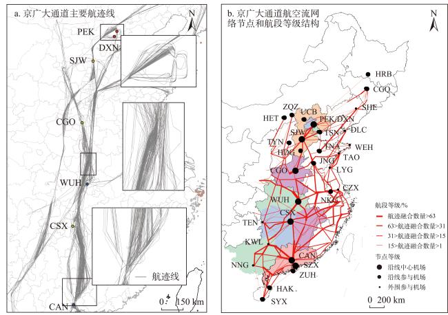
表1 京广大通道机场类型划分Tab. 1 Airport type division of Beijing-Guangzhou Corridor |
| 机场类型 | 划分标准 | 机场名称 |
|---|---|---|
| 8个沿线中心机场 | 航迹融合数量>63%;距离比值>70% | PEK(北京首都机场)、DXN(北京大兴机场)、SJW(石家庄正定机场)、CGO(郑州新郑机场)、WUH(武汉天河机场)、CSX(长沙黄花机场)、CAN(广州白云机场)、SZX(深圳宝安机场) |
| 14个沿线参与机场 | 63%>航迹融合数量>31%;距离比值>70% | ZQZ(张家口宁远机场)、UCB(乌兰察布集宁机场)、HRB(哈尔滨太平机场)、CGQ(长春龙嘉机场)、HET(呼和浩特白塔机场)、HAK(海口美兰机场)、SYX(三亚凤凰机场)、ZUH(珠海金湾机场)、TYN(太原武宿机场)、TSN(天津滨海机场)、TNA(济南遥墙机场)、JNG(济宁曲阜机场)、HDG(邯郸机场)、NKG(南京禄口机场) |
| 9个外围参与机场 | 31%>航迹融合数量>1%;距离比值<70% | TEN(铜仁凤凰机场)、KWL(桂林两江机场)、NNG(南宁吴圩机场)、SHE(沈阳仙桃机场)、TAO(青岛流亭机场)、LYG(连云港白塔埠机场)、CZX(常州奔牛机场)、DLC(大连周水子机场)、WEH(威海大水泊机场) |
表2 京广大通道脆弱节点和脆弱航段识别Tab. 2 Identification of vulnerable nodes and vulnerable segments of Beijing-Guangzhou Corridor |
| 脆弱节点识别 | R | V | Rrec | Vrec | 脆弱航段识别 | R | V | Rrec | Vrec | |
|---|---|---|---|---|---|---|---|---|---|---|
| 沿线 中心 机场 | PEK | 0.58 | 0.46 | 0.45 | 0.14 | PEK/DXN-SJW* | 0.78 | 0.23 | 0.09 | -0.12 |
| DXN | 0.77 | 0.26 | 0.41 | 0.11 | ||||||
| SJW | 0.63 | 0.67 | 0.49 | 0.15 | SJW-CGO | 0.16 | 0.64 | 0.12 | 0.39 | |
| CGO | 0.61 | 0.36 | 0.17 | 0.24 | ||||||
| WUH | 0.69 | 0.12 | 0.46 | 0.09 | CGO-WUH | 0.58 | 0.48 | 0.19 | 0.36 | |
| CSX* | 0.45 | 0.24 | 0.13 | -0.41 | ||||||
| CAN | 0.61 | 0.33 | 0.36 | 0.06 | WUH-CSX* | 0.31 | 0.61 | -0.21 | 0.28 | |
| SZX | 0.78 | 0.64 | 0.42 | 0.33 | ||||||
| 沿线参与机场 | ZQZ | 0.16 | 0.15 | 0.07 | 0.05 | ZQZ-TYN | 0.23 | 0.36 | 0.14 | 0.25 |
| UCB | 0.71 | 0.46 | 0.12 | 0.13 | ||||||
| HRB | 0.45 | 0.58 | 0.30 | 0.49 | CSX-CAN | 0.72 | 0.79 | 0.37 | 0.61 | |
| CGQ | 0.36 | 0.69 | 0.16 | 0.58 | CGQ-SJW* | 0.45 | 0.15 | 0.30 | -0.11 | |
| HET | 0.56 | 0.61 | 0.47 | 0.16 | HAK-SYX | 0.69 | 0.68 | 0.11 | 0.46 | |
| HAK* | 0.21 | 0.67 | -0.19 | 0.40 | ||||||
| SYX* | 0.65 | 0.71 | -0.14 | 0.63 | ||||||
| ZUH | 0.76 | 0.13 | 0.12 | 0.10 | ZUH-HAK | 0.24 | 0.96 | 0.13 | 0.69 | |
| TYN | 0.85 | 0.46 | 0.62 | 0.34 | ||||||
| TSN | 0.49 | 0.68 | 0.24 | 0.18 | TYN-CSX* | 0.46 | 0.24 | 0.35 | -0.03 | |
| TNA | 0.72 | 0.49 | 0.46 | 0.16 | ||||||
| JNG | 0.23 | 0.45 | 0.18 | 0.05 | ||||||
| HDG | 0.64 | 0.51 | 0.33 | 0.49 | HDG-CGO* | 0.72 | 0.61 | 0.10 | -0.25 | |
| NKG | 0.33 | 0.86 | 0.16 | 0.58 | CGO-WUH* | 0.69 | 0.15 | 0.45 | -0.33 | |
| 外围参与机场 | TEN | 0.55 | 0.15 | 0.43 | 0.14 | TEN-KWL | 0.41 | 0.77 | 0.34 | 0.56 |
| KWL* | 0.13 | 0.57 | -0.26 | -0.25 | KWL-CSX | 0.48 | 0.87 | 0.17 | 0.16 | |
| NNG | 0.61 | 0.36 | 0.53 | 0.16 | DLC-YNT* | 0.96 | 0.69 | 0.76 | -0.13 | |
| SHE* | 0.66 | 0.62 | -0.33 | -0.31 | SHE-PEK/DXN* | 0.15 | 0.44 | -0.20 | 0.33 | |
| TAO* | 0.24 | 0.88 | -0.63 | -0.03 | TAO-JNG* | 0.23 | 0.65 | -0.15 | 0.11 | |
| LYG | 0.43 | 0.45 | 0.18 | 0.35 | LYG-CZX | 0.49 | 0.68 | 0.35 | 0.45 | |
| CZX | 0.28 | 0.64 | 0.17 | 0.26 | CZX-WUH* | 0.54 | 0.87 | -0.18 | 0.28 | |
| DLC* | 0.38 | 0.13 | 0.26 | -0.19 | DLC-TNA | 0.92 | 0.64 | 0.57 | 0.16 | |
| WEH* | 0.19 | 0.97 | -0.24 | 0.43 | WEH-TAO* | 0.47 | 0.13 | -0.46 | -0.41 | |
由衷感谢匿名审稿专家对稿件结果分析深度、逻辑严谨性以及语言表达规范性的专业赐教与相助,使本文获益匪浅。
| [1] |
|
| [2] |
|
| [3] |
|
| [4] |
|
| [5] |
|
| [6] |
|
| [7] |
|
| [8] |
|
| [9] |
|
| [10] |
|
| [11] |
|
| [12] |
|
| [13] |
|
| [14] |
董雅晴, 路紫, 刘媛. 中国空中廊道划设与时空拥堵识别及其航线流量影响. 地理学报, 2018, 73(10): 2001-2013.
[
|
| [15] |
|
| [16] |
|
| [17] |
|
| [18] |
|
| [19] |
|
| [20] |
|
| [21] |
|
| [22] |
|
| [23] |
|
| [24] |
董雅晴, 路紫, 张一诺. 航空流网络解构与空域资源动态配置研究: 以京-成空中廊道为例. 地理与地理信息科学, 2022, 38(1): 116-123, 132.
[
|
| [25] |
|
| [26] |
|
| [27] |
|
| [28] |
张一诺, 路紫, 丁疆辉. 京广空中廊道系统延误弹性测算与航空流运行结构分析. 热带地理, 2020, 40(2): 194-205.
[
|
| [29] |
|
| [30] |
|
| [31] |
|
| [32] |
|
| [33] |
|
| [34] |
|
| [35] |
|
| [36] |
|
| [37] |
|
| [38] |
|
/
| 〈 |
|
〉 |