
新疆石河子农区土壤含盐量定量反演及其空间格局分析
作者简介:陈实(1987- ),男,安徽省安庆人,硕士,主要从事草原遥感监测和土地退化研究。E-mail:shic11@126.com
收稿日期: 2014-03-03
要求修回日期: 2014-09-08
网络出版日期: 2014-11-10
基金资助
新疆生产建设兵团博士资金专项(2012BB001)
科技支疆计划项目(2013AB017)
国家国际科技合作专项(2013DFR30760)
Quantitative inversion of soil salinity and analysis of its spatial pattern in agricultural area in Shihezi of Xinjiang
Received date: 2014-03-03
Request revised date: 2014-09-08
Online published: 2014-11-10
Copyright
盐渍化严重威胁着土地持续耕作和粮食生产安全,土壤含盐量的快速反演和及时监测,对新疆石河子农区农业可持续发展有着重大意义。以Landsat-8 OLI遥感影像与野外采样测定的72个样点土壤含盐量为数据基础,引入土壤亮度指数、土壤湿度指数、土壤盐盖度指数和土壤辐射水平指数等构建的特征遥感指数定量反演新疆石河子农垦区土壤含盐量,并对其空间布局进行了分析。研究表明:① 利用遥感影像像元特征遥感指数值反演地面对应土壤含盐量的精度较好,反演方法可行,反演精度为66%;② 反演得到土壤含盐量空间分布图在空间上等级明显,层次分明,呈现出“一带一区”的格局,“一带”是玛纳斯流域形成的盐渍化程度较高的条带,“一区”是内在土质形成的严重盐渍化区域;③ 在新疆石河子农区中,35.40%的棉田适合耕作,64.60%的棉田耕地需要进行改良,农区土壤盐渍化治理仍十分紧迫。
陈实 , 高超 , 徐斌 , 金云翔 , 李金亚 , 马海龙 , 赵芬 , 郭剑 , 杨秀春 . 新疆石河子农区土壤含盐量定量反演及其空间格局分析[J]. 地理研究, 2014 , 33(11) : 2135 -2144 . DOI: 10.11821/dlyj201411013
Salinization has been a serious threat to continuous farming and grain production security, therefore, the rapid inversion of soil salinity is particularly important. The monitoring and prevention of soil salinization are of great significance to agricultural sustainable development in Shihezi, Xinjiang. In this study, we took the remote sensing image of Landsat-8 OLI and the soil salinity of 72 samples measured in the field as a data base. Then we introduced the soil brightness index, soil moisture index, soil cover degree index and soil radiation level index. Finally we built feature remote sensing index to invert quantitatively the soil salinity of Land Reclamation District of Shihezi in Xinjiang, and analyzed the spatial pattern of it. The results showed that: ① The accuracy of characteristic remote sensing index value of image pixel to invert soil salinity which corresponded to the ground was better. The inversion method was feasible. REE and RMSM, the precision validation index of inversion model were 3.07 and 0.34 respectively, and retrieval accuracy was 66%; ② The distribution map of soil salinity with obvious grades and clear levels presented the pattern of 'one stripe and one region'. One stripe referred to the stripe with high salinization formed by Manas basin, mostly located in the alluvial plains, low-lying area, and reservoir areas. And one region referred to the region with serious salinization caused by soil texture. ③ In the farming areas, the non-salinization cotton area accounted for 14.02%, the mild salinization cotton area accounted for 21.38%, the moderate salinization cotton area accounted for 21.27%, severe salinization cotton area accounted for 29.99%, and saline accounted for 13.30% in cotton area. Some 35.40% of the cotton field was suitable for cultivation and 64.60% of the cotton field which needed to be improved. It is urgent to control soil salinization of farming areas.
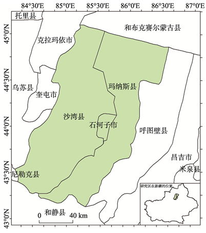
Fig. 1 The geographical situation of the study area图1 研究区位置图 |
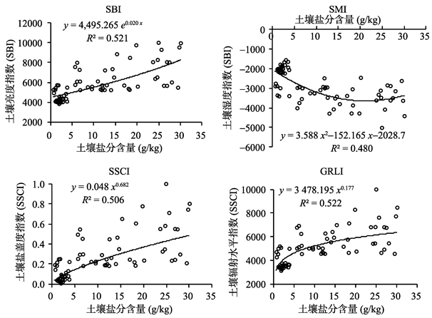
Fig. 2 The fitting scatter plot diagram of the feature remote sensing index value and the soil salinity图2 各种特征遥感指数值与土壤盐分含量拟合散点图 |
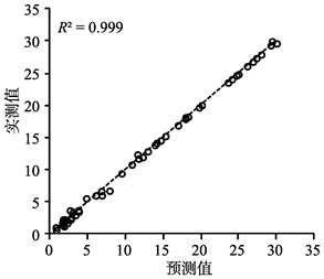
Fig. 3 The precision results of inversion model training of neural network图3 神经网络反演模型训练精度结果 |
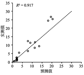
Fig. 4 The validation scatter plot of BP neural network inversion of soil salinity图4 BP神经网络反演土壤含盐量验证散点图 |
Tab. 1 The hierarchy standard table of soil salinization degree表1 土壤盐渍化程度等级划分标准表 |
| 等级 | 土壤含盐量S(g/kg) | 土壤盐渍化程度 |
|---|---|---|
| 五级 | 0≤S<3 | 非盐渍化土 |
| 四级 | 3≤S<6 | 轻度盐渍化土 |
| 三级 | 6≤S<10 | 中度盐渍化土 |
| 二级 | 10≤S<20 | 重度盐渍化土 |
| 一级 | S≥20 | 盐土 |
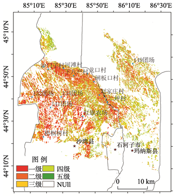
Fig. 5 The spatial pattern of inversion of soil salinity in cotton field图5 研究区棉田土壤盐分含量反演空间格局图 |
The authors have declared that no competing interests exist.
| [1] |
|
| [2] |
[
|
| [3] |
|
| [4] |
[
|
| [5] |
[
|
| [6] |
[
|
| [7] |
[
|
| [8] |
[
|
| [9] |
[
|
| [10] |
|
| [11] |
|
| [12] |
|
| [13] |
[
|
| [14] |
[
|
| [15] |
[
|
| [16] |
[
|
| [17] |
[
|
| [18] |
[
|
| [19] |
[
|
| [20] |
[
|
| [21] |
[
|
| [22] |
[
|
| [23] |
[
|
| [24] |
[
|
| [25] |
[
|
| [26] |
[
|
| [27] |
[
|
| [28] |
[
|
| [29] |
[
|
| [30] |
[
|
| [31] |
[
|
/
| 〈 |
|
〉 |