
京奉铁路之历史地理研究(1881-1912年)
作者简介:黄清琦(1977- ),男,台中市人,研究方向为地图学和历史地理学。E-mail:120870525@qq.com
收稿日期: 2013-12-29
要求修回日期: 2014-07-19
网络出版日期: 2014-11-10
基金资助
国家自然科学基金项目(41371157)
国家自然科学基金重点项目(41230634)
A historical geography research of Peking-Mukden Railway under the vision of modernization (1881-1912)
Received date: 2013-12-29
Request revised date: 2014-07-19
Online published: 2014-11-10
Copyright
京奉铁路是近代中国第一条干线铁路,全长840 km,起始于1881年的唐胥铁路建设,经历许多波折,兴建时间长达31年,可以视为近代中国铁路发展的缩影。在中国近代化的过程之中,近代交通的发展受到守旧派的阻力相当巨大,其中铁路建设阻力更大。京奉铁路从清帝国首都北京修筑至陪都盛京,并非一帆风顺,而是在各种错综复杂的因素影响下艰难分段延展。在地理空间的展布上,京奉铁路的路线走向受到多种因素的影响,其中包含政治因素、军事因素、经济因素、地理因素、风俗习惯等。本研究将藉助GIS,对相关区域旧版大比例尺地形图(包含战前日本所制的地形图在内)做定位与套迭,取得旧日铁路路线、城垣、河道、皇家苑囿等地理信息进行分析,探讨影响京奉铁路路线与各种因素的关系。在地图资料之外,本研究将与其他的文字史料相互参照,以分析在唐山—胥各庄段、北京附近、以及奉天附近三个研究区域里,前述各种因素对京奉铁路发展上的影响。
黄清琦 , 陈喜波 . 京奉铁路之历史地理研究(1881-1912年)[J]. 地理研究, 2014 , 33(11) : 2180 -2194 . DOI: 10.11821/dlyj201411017
Peking-Mukden Railway, which was 840 kilometers long, was the first railway in China. It took 31 years to build this railway, starting from the construction of Tangshan-Xugezhuang Railway in 1881. It could be taken as a microcosm of modern China's railway development. In the process of Chinese modernization, the development of modern transportation encountered huge resistance from the conservative force, so did the railway construction. Peking-Mukden Railway was extended section by section from Peking, the capital of the Qing Empire to the alternative capital Mukden. On the distribution of geographical space, the route trend of Peking-Mukden Railway was affected by many factors, including political, military, economic and geographic conditions as well as social customs. The research, with the aid of GIS, will position and overlap the related original old topographic maps (including the prewar topographic maps made by Japan) at a large scale, abstract the geographic information of the old railway lines, city walls, canals, royal hunting ground, and discuss the relationship between the railway development and various factors. In addition to the map materials, the study will compare with other historical data and examine the influence of the aforementioned factors on the development of Peking-Mukden Railway.
Key words: Peking-Mukden Railway; historical geography; topographic maps; GIS; railway history
Tab. 1 The course of China and Japan's learning surveying and mapping from western countries表1 中日两国学习西法测绘的历程 |
| 中国[1] | 日本[2] |
|---|---|
| • 海域测量 1866:马尾船政学堂学习西法测绘 • 陆地测量 1885:天津武备学堂学习西法测绘 1901:清末新政下令各省西法制作舆地图,因 无固定章程,结果良莠不齐 1908:陆军部奏定测绘章程,以三角测量新法 推动制式地形图测绘 | • 海域测量 1860:学习西法测绘神奈川港 1872:水路寮海图1号制作(釜石港) • 陆地测量 1871:工部省测量司成立 1875:三角测量法实测北海道 1878:上野原公园实测 1883:关东地区实施迅速测图 1884:全国开始实施三角测量 |
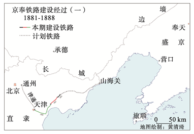
Fig. 1 The first stage of Beijing-Mukden Railway's building图1 1881-1888年京奉铁路修筑示意图 |
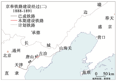
Fig. 2 The second stage of Beijing-Mukden Railway's building图2 1888-1891年京奉铁路修筑示意图 |
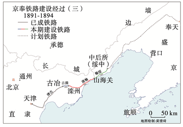
Fig. 3 The third stage of Beijing-Mukden Railway's building图3 1891-1894年京奉铁路修筑示意图 |
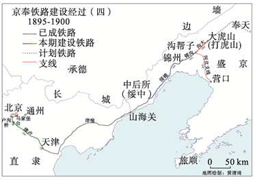
Fig. 4 The fourth stage of Beijing-Mukden Railway's building图4 1895-1900年京奉铁路修筑示意图 |
Fig. 5 The fifth stage of Beijing-Mukden Railway's building图5 1900-1904年京奉铁路修筑示意图 |
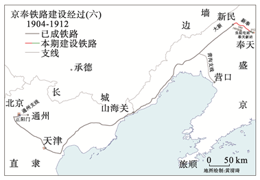
Fig. 6 The sixth stage of Beijing-Mukden Railway's building图6 1904-1912年京奉铁路修筑示意图 |
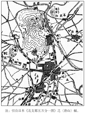
Fig. 7 From the Tangshan sheet of 1/50000 maps about North China, by Japan land surveying and mapping ministry, 1910图7 1910年京奉铁路唐山站周边示意图 |
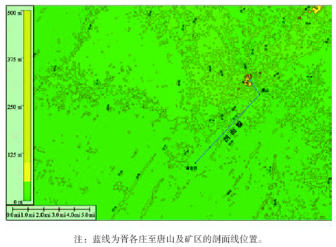
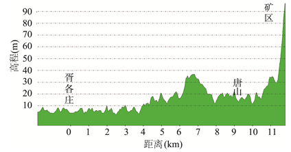
Fig. 8 Contour line and profile line of the area between Tangshan and Xugezhuang (1900)图8 1900年唐山—胥各庄等高线及剖面线 |
Fig. 9 Slope analysis of the area between Tangshan and Xugezhuang图9 唐山—胥各庄间坡度分析 |
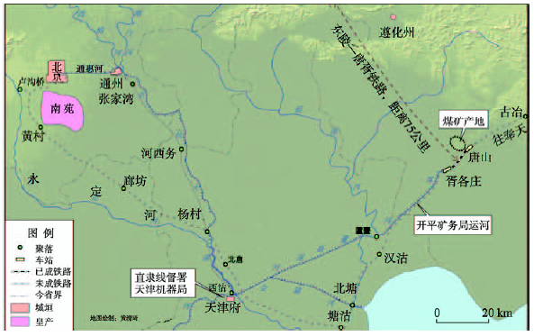
Fig. 10 Location of the section from Tanshan to Xugezhuang of Beijing-Mukden Railway图10 京奉铁路唐胥段示意图 |
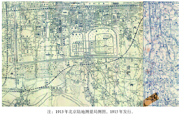
Fig. 11 The 1/25000 topographic map of Beijing and its vicinity by Beijing land surveying and mapping bureau, 1913, composed of Majiapu sheet, Xiaohongmen sheet图11 《北京附近二万五千分一地形图》〈马家铺〉、〈小红门〉组图局部 |
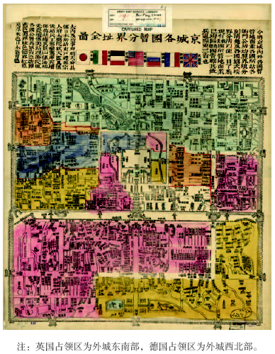
Fig. 12 Map of occupied areas by foreigners in Beijing in 1901图12 1901年京城各国暂分界址全图 |
Fig. 13 Location of Peking-Mukden railway in the vicinity of Beijing in 1896-1901图13 1896-1901年京奉铁路北京附近位置图 (1896-1901年) |
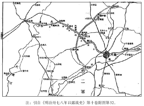
Fig. 14 The railway from Fengtian to Xinminfu, part of the map of military depots of the third army group图14 日俄战争时期奉天周边轻便铁道路线示意图 |
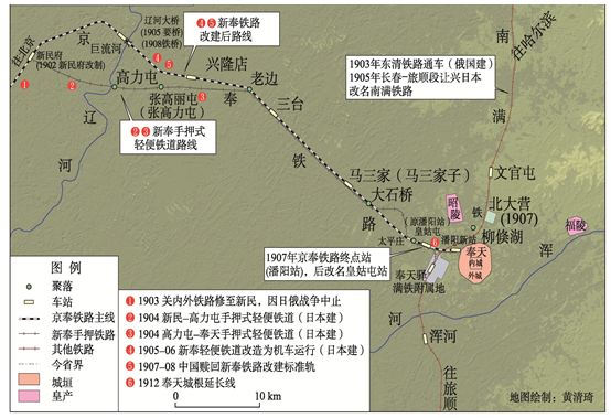
Fig. 15 Peking-Mukden Railway in the vicinity of Fengtian (Mukden)图15 1904-1912年京奉铁路奉天附近线路示意图(1904-1912年) |
The authors have declared that no competing interests exist.
| [1] |
[
|
| [2] |
[
|
| [3] |
[
|
| [4] |
[
|
| [5] |
北华捷报. 星期三新报. 1879-02-07.
[North China Herald. Wednesday Shanghai News. 1879-02-07.]
|
| [6] |
[
|
| [7] |
[
|
| [8] |
[
|
| [9] |
[
|
| [10] |
[
|
| [11] |
[
|
| [12] |
[
|
| [13] |
[
|
| [14] |
[
|
| [15] |
[
|
| [16] |
[
|
| [17] |
[
|
| [18] |
[
|
| [19] |
[
|
| [20] |
[
|
| [21] |
[
|
| [22] |
[
|
/
| 〈 |
|
〉 |

