
四川省山地类型界定与山区类型划分
作者简介:范建容(1969- ),女,四川井研人,研究员,博士生导师,主要从事山地环境遥感与地理信息系统研究。E-mail:fjrong@imde.ac.cn
收稿日期: 2014-05-13
要求修回日期: 2014-10-11
网络出版日期: 2015-01-10
基金资助
国家自然科学基金项目(41071091)
Mountain demarcation and mountainous areadivisions of Sichuan province
Received date: 2014-05-13
Request revised date: 2014-10-11
Online published: 2015-01-10
Copyright
山地类型的界定是科学认知山地规律的基础,对山地科学的发展有着基础性的意义。山地科学研究的出发点与落脚点,是为了促进山区区域在各方面的可持续发展,所以在山地类型界定的研究结果基础上对山区类型进行划分,是山区可持续发展的基本科学依据。采用GIS技术并结合DEM数据,对四川省的山地类型进行界定,同时对山区的类型进行划分。在山地类型界定涉及到的地形起伏度计算中,对均值变点法的应用结果进行了讨论与改进,得到地形起伏度最佳统计单元为9.92 km2。将四川省山地类型界定为丘陵、低山、中低山、中山、次高山、高山、极高山;将山区划分为纯丘陵县、半山区县、准山区县、显山区县、整山区县,并对山区发展的政策方向提出了一定的建议。
范建容 , 张子瑜 , 李立华 . 四川省山地类型界定与山区类型划分[J]. 地理研究, 2015 , 34(1) : 65 -73 . DOI: 10.11821/dlyj201501006
Mountain type demarcation, which is the foundation for scientifically cognizing mountain laws, is of fundamental significance to the development of mountain science. And the starting point and ultimate goal of mountain science research, is to promote sustainable development in aspects such as natural, cultural and others of mountainous areas. So division of mountainous areas, on the basis of the scientific mountain demarcation research, is a fundamental scientific basis for sustainable mountain development in mountain regions. This study uses geographic information system (GIS) technology combined with digital elevation model (DEM) data to demarcate Sichuan mountain type and to divide mountainous areas in Sichuan province. However, some problems emerged and finally are solved during the process of relief amplitude calculation which is essential for demarcation of mountains, for instance, the change point computed by applying mean change point method for the fisrt time is not the point that meets the criterion of best statistical point unit in geographical significance. Then data in line with the actual physical sense is applied to calculate the change point by using mean change point method for the second time, and the best statistical window is proved to be 9.92 km2. As the result shows, the research demarcates mountain types of Sichuan to hills, low mountain, middle-low mountain, middle mountain, sub-high mountain, high mountain and extremely high mountain, and divides mountainous regions to pure hilly county, mid-mount county, quasi-mount county, apparent mount county and whole mount county. In the end, this paper suggests that governments could formulate and implement not only a series of macro policies for the whole mountainous areas but also specific policies for each type of mountainous counties to promote the development of mountainous regions.
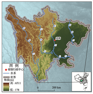
Fig. 1 Location of the study area图1 研究区位置 |
Tab. 1 Index for mountain type division in Sichuan表1 四川省山地类型界定指标 |
| 山地类型 | 海拔(m) | 附加条件 |
|---|---|---|
| 丘陵 | <500 | 地形起伏度≥50 m |
| 低山 | [500, 1000) | 7 km半径内局部海拔变化≥300 m |
| 中低山 | [1000, 1500) | 坡度≥5° |
| 中山 | [1500, 2500) | 坡度≥2° |
| 次高山 | [2500, 3500) | |
| 高山 | [3500, 4500) | |
| 极高山 | ≥4500 |
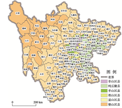
Tab. 2 Index for mountainous area division in Sichuan表2 四川省山区类型划分指标 |
| 山区类型 | 指标 |
|---|---|
| 非山区县 | 山地面积比率<40% |
| 纯丘陵县 | 丘陵面积比率≥80% (若某县类型既是纯丘陵县又是其他类别,则归为此类) |
| 半山区县 | 40%≤山地面积比率<60% |
| 准山区县 | 60%≤山地面积比率<80% |
| 显山区县 | 80%≤山地面积比率<100% |
| 整山区县 | 山地面积比率=100% |
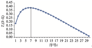
Fig. 2 Relief amplitude variation curve图2 地形起伏度变化曲线 |
Fig. 3 Difference between S and Si variation curve by applying mean change point for the first time图3 首次均值变点S与Si差值变化曲线 |
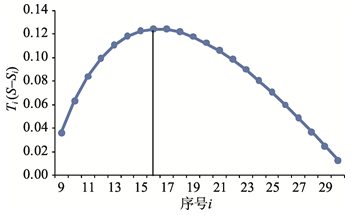
Fig. 4 Difference between S and Si variation curve by applying mean change point for the second time图4 二次均值变点S与Si差值变化曲线 |
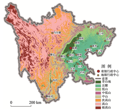
Fig. 5 Distribution of mountain types in Sichuan图5 四川省山地类型分布 |
Fig. 6 Distribution of mountainous area types in Sichuan图6 四川省山区类型分布 |
The authors have declared that no competing interests exist.
| [1] |
[
|
| [2] |
[
|
| [3] |
[
|
| [4] |
[
|
| [5] |
[
|
| [6] |
[
|
| [7] |
[
|
| [8] |
[
|
| [9] |
[
|
| [10] |
[
|
| [11] |
|
| [12] |
|
| [13] |
[
|
| [14] |
[
|
| [15] |
[
|
| [16] |
[
|
| [17] |
[
|
/
| 〈 |
|
〉 |
