中国大陆海岸线随机前分形分维及其长度不确定性探讨

  • 马建华 , 1, 2 ,
  • 刘德新 1 ,
  • 陈衍球 1
展开
  • 1. 河南大学资源与环境研究所, 开封 475004
  • 2. 教育部人文社会科学重点研究基地河南大学黄河文明与可持续发展研究中心, 开封 475001

作者简介:马建华(1959- ),男,河南清丰人,教授,博士生导师,主要从事土壤环境污染防治、自然地理综合研究。 E-mail:

收稿日期: 2014-07-03

  要求修回日期: 2014-12-18

  网络出版日期: 2015-02-10

基金资助

国家自然科学基金项目(41171409)

教育部人文社会科学重点研究基地重大项目(12JJD790023)

教育部和河南省共建河南大学项目(SBGJ090101)

Random prefractal dimension and length uncertainty of the continental coastline of China

  • MA Jianhua , 1, 2 ,
  • LIU Dexin 1 ,
  • CHEN Yanqiu 1
Expand
  • 1. Institute of Natural Resources and Environment, Henan University, Kaifeng 475004, Henan, China
  • 2. Key Research Institute of Yellow River Civilization and Sustainable Development, Henan University, Kaifeng 475004, Henan, China

Received date: 2014-07-03

  Request revised date: 2014-12-18

  Online published: 2015-02-10

Copyright

《地理研究》编辑部

摘要

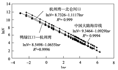
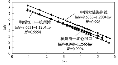
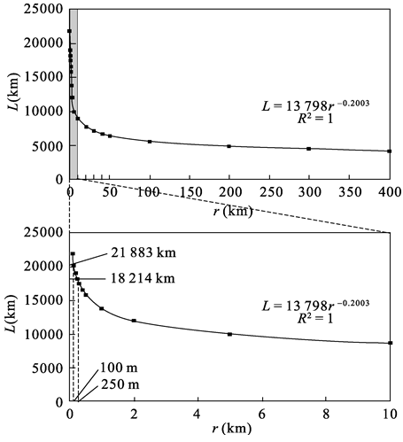
一个国家或地区海岸线长度的确定,应首先计算其标度区和分维,然后选用标度区下限附近的量测尺度进行量算。以1:50万电子地图为基础,在ArcGIS技术支持下选用33种尺度研究中国大陆海岸线的标度区及其盒计维,用手工作业法量测海岸线的量规维,并对中国现行大陆海岸线长度的可靠性进行讨论。结果表明:中国大陆海岸线的标度区在400~0.1 km之间。海岸线量规维和盒计维分别是1.2004和1.0929,量规维比盒计维更能精确表征海岸线不规则程度。杭州湾以南和以北海岸线的量规维分别是1.2565和1.1204。当量测尺度为0.1 km时,中国大陆海岸线的长度约21900 km;当尺度为0.25 km时,长度为18214 km,接近现行海岸线长度。

本文引用格式

马建华 , 刘德新 , 陈衍球 . 中国大陆海岸线随机前分形分维及其长度不确定性探讨[J]. 地理研究, 2015 , 34(2) : 319 -327 . DOI: 10.11821/dlyj201502011

Abstract

Coastline can be treated as a random prefractal object whose length is uncertain. Different lengths of the continental coastline of China were promulgated in the last century: 8000 km in 1914, 10537 km in 1935, 14000 km in the 1950s, and 18400.5 km in 1975, which has been used till now. How long is the continental coastline of China? To determine the coastline length of a country, we should calculate the scaling range and fractal dimension of the coastline first, and then measure the coastline length with the measurement scale at the lower or near the limit of the scaling range. Although many scholars investigated the fractal dimension and the length of the continental coastline of China, yet none of them identified the scale range of the coastline, which led to the results slightly inaccurate. The scaling range of the continental coastline of China on 1:500,000 map from the Google Earth Website was determined with 33 measurement scales, and the box-counting dimension was calculated automatically with the aid of ArcGIS software, while the divider dimension was calculated manually. Reliability of the length of Chinese coastline using popularly today was discussed in this paper. The results show that the scaling range of the continental coastline of China is from 400 km to 0.1 km. Within the scaling range, the box-counting dimension and the divider dimension of the coastline are 1.2004 and 1.0929, respectively. Divider dimension represents the irregularity of coastline more accurately than the box-counting dimension because the divider method is the most accurate method to measure the fractal dimension for linear geometric object. The divider dimension of the coastline south of the Hangzhou Bay is 1.2565, and that of north of the bay is 1.1204. The length of the continental coastline of China is about 21900 km when the measurement scale is 0.1 km, and 18214 km when the measurement scale is 0.25 km, which is close to the continental length of China (18400 km) used widely today. The measurement scale of 0.25 km is within the scaling range and in the vicinity of the lower scaling range limit, consequently, the current coastline length of China is accurate and acceptable. Our recommendation is that the fractal dimension of 1.2004 and measurement scale of 0.25 km should be annotated when the current coastline length of China is cited.

1 引言

1949年以前,记载中国大陆海岸线(以下简称中国海岸线)长度较早的文献是1914年出版的《中华地理全志》[1],长度约8000 km。1935年《水陆地图审查委员会会刊》第1期,将中国海岸线长度确定为10537 km[2],被当时很多文献引用[3,4]。解放初期,国家权威部门在大比例尺旧海图的基础上,经逐段量算得到的海岸线长度是14000 km,一直使用到1975年[5,6]。1972年,解放军海军航海保证部收集当时最新的大比例尺地图,应用卡规法、丝线法、曲线计法等多种方法相互验证,量测的海岸线长度是18400.5 km。这一数据经国务院、中央军委批准,以《关于使用我国大陆海岸线长度和海洋岛屿数量及其岸线长度新数据的通知》(国发[1975]78号)的形式于1975年6月7日对外公布,这就是当前中国普遍使用的海岸线长度[7-9]
事实上,海岸线是典型的地理分形事物之一,其长度依测量尺度的大小而变化,海岸线长度是不确定的,有研究认为是无限长的[10-13]。所以,不加约束条件的海岸线长度不科学,也没有意义。Mandelbrot研究表明[10,14],尽管海岸线长度依测量尺度大小而变化,但其分维(Fractal Dimension, D)值不变。分维是描述海岸线不规则程度的特征参量[15],其值域是1<D<2,D值越大,海岸线愈曲折和复杂。线状分形分维的计算方法有量规法(折线法)[16-18]、盒计法(网格法)[16,17,19,20]、随机噪声法[14,18]等。近几十年来,国内外很多学者用不同方法计算了不同国家或地区的海岸线分维。英国、澳大利亚和南非海岸线的分维分别是1.25、1.13和1.02[10];美国Delaware Bay海岸线分维是1.4[21],加利福尼亚东、西海岸的分维分别是1.15和1.19[18],美国东、西海岸线的分维分别是1.27和1.70[22],缅因州海岸线的分维变化在1.11~1.35之间[23];挪威南部海岸线的分维是l.52[24];格陵兰岛的海岸线分维是1.23[16];北极Titan湖岸线的分维是1.27[25];克罗地亚Cres岛的海岸线分维是1.118[26];加拿大芬迪湾海岸线的分维变化在1.12~1.7之间[27];巴拿马城海岸线分维变化在1.017~1.196之间[28]。国内很多学者也对中国海岸线或其不同区段的分维进行过计算。Su等[29]、Zhu等[30]、韩雪培等[31]和刘孝贤等[32]量算的中国海岸线分维分别是1.195、1.16、1.1882和1.1401;Zhu等[33]量算的江苏省海岸线分维是1.0696,冯金良等[34]量算的渤海湾岸线分维变化在1.0199~1.1252之间,Xu等[35]量算的山东—天津海岸线的分维是1.1383,叶小敏等[36]量算的胶州湾海岸线的分维是1.0801,戴志军等[37]量算的华南弧形海岸线的分维是1.1465。
分形包括规则分形(regular fractal)和随机分形(random fractal)两种。前者在所有尺度上都具有精确的自相似性(exact self-similarity),如Koch curve、Cantor set和Sierpinski carpet等;后者具有统计自相似性(statistical self-similarity)。地理系统中的分形都属于随机分形,并且只在特定的标度区(scaling range)内才表现出自相似性,称之为前分形(prefractal)[24,38,39],如海岸线、流域边界、国境线、河流中泓线、山脊线、树冠、城市结构等[39,40]。但前述海岸线分维研究几乎都没有认真讨论标度区问题,如果将标度区之外的数据包含在内进行分维计算,所得到的分维必然不准确。海岸线的长度是客观存在的,现实生活中不可能用很小的尺度(如<1 m)测量一个国家或地区的海岸线长度,“海岸线无限长”是一个伪命题。那么,究竟如何确定海岸线的长度呢?另外,中国现行的海岸线长度的可靠性如何?其量测尺度是多少?量测尺度是否在标度区范围内?这些问题都需要进一步开展研究。
鉴于此,以电子地图为工作底图,在增加量测尺度数目、寻找标度区的基础上,应用手工量规法和ArcGIS支持下的盒计法分别计算中国海岸线分维,探讨海岸线长度的不确定性、合理长度、现行长度的量测尺度及其是否在标度区范围内等问题。本研究对于揭示中国海岸线的分形几何学特征,明确现行海岸线长度的约束条件及其可靠性都具有一定意义。

2 研究方法

由于地图分辨率和制图综合等原因,不同比例尺的同一海岸线地图的弯曲程度不同。随着比例尺的增大,分维不断减小[31,32],长度也会随之发生变化,所以选择合适比例尺的地图是量算海岸线分维必需考虑的重要因素。工作底图比例尺的大小应根据研究区域的面积或地物大小确定。中国海岸线漫长,从整体上观察海岸线的比例尺不宜太大,但也不宜太小。选择能在室内展示的1 50万地图进行海岸线分维量算。1 50万Google Map的空间分辨率约180 m/像素,基本可以满足量测中国海岸线的精度要求(最小量测尺度100 m或200 m);若用1 5万的地图,其空间分辨率约35 m/像素,虽然精度更高,但仅适合量测小范围的海岸线,不完全适合整个中国海岸线的量测。

2.1 盒计法

用Google Map V1.1截获器,从Google Earth网站上依次下载北起鸭绿江口、南至北仑河口的海岸线地图,共计10幅,其投影为Web Mercator或Spherical Mercator投影。先用ArcGIS 10.0软件中的线状构造工具对海岸线进行矢量化;再在其Spatial Adjustment模块支持下,用中国1 50万矢量化政区图(Albers投影或正轴等面积割圆锥投影)对海岸线矢量图进行地理配准,最终形成统一的1 50万中国海岸线矢量图。在矢量化过程中,根据实际影像的海陆交界线,参照夏东兴等[41]对海岸线的划定方法进行海岸线定界。入海河口的界限确定在河口突然变宽的地方,窄而长的防浪堤或观光堤不计入海岸线的范畴。
盒计维所用盒子(网格)边长最小尺度(rmin),一般根据地图分辨率(0.3~0.5 mm地图单元)换算成实际距离而定[29,31],因此1 50万地图的rmin应在150~250 m之间。有学者[29, 32]认为,rmin之后的尺度取值依次为rmin×2n,最大尺度(rmax)没有明确限制。然而按照分形理论,对于各个量测尺度的取值间隔没有严格规定,可以是等距、指数和随机的,对分维计算没有影响[16,25,33,36,37]。为了寻找中国海岸线的标度区,采用分段等距方法设置尽量多的量测尺度,从小到大依次为0.01 km、0.05 km、0.1 km、0.2 km、0.5 km、1 km、1.5 km、2 km、2.5 km、5 km、10 km、15 km、20 km、25 km、30 km、35 km、40 km、45 km、50 km、60 km、70 km、80 km、90 km、100 km、150 km、200 km、250 km、300 km、400 km、500 km、600 km、700 km、800 km,共33个量测尺度。
用ArcGIS中的ArcToolbox转栅格功能模块,按盒计法思路分别自动提取覆盖海岸线所需要的各个量测尺度(r)的网格数目(N)。根据各尺度所对应的网格数目,借助Excel 2007绘制lnN-lnr关系曲线。删除曲线中直线段(对应的r范围即是标度区)之外的数据后,自动生成拟合方程:
lnN = C - Dlnr (1)
式中:C是海岸线不随标度变化的常数;D是海岸线分维(盒计维)。实际上,lnN-lnr曲线的斜率就是分维,C是其纵截距。
中国海岸线大致以杭州湾为界,以南基本上属于复杂、曲折的基岩港湾海岸,以北相对比较简单,表现为基岩港湾海岸与较平直的平原海岸交错分布[7-9]。为了反映中国海岸线的上述差异,分别量算鸭绿江口—杭州湾岸线段、杭州湾—北仑河口岸线段以及中国整体海岸线的分维。

2.2 量规法

由于目前应用量规法测量海岸线分维尚无法实现自动化[38],故采用传统的手工作业法进行量算。将各幅1 50万海岸线地图依次拼接并粘贴于墙上,用不同步长或开度(r)的圆规沿海岸线一端逐段量测至另一端,分别记录各步长的线段数目(N)。按上述盒计法的分维计算式(1)得到海岸线分维,即量规维。因为盒计法已经得到中国海岸线的标度区(0.1~400 km,见结果分析与讨论部分),又考虑到当步长是2.5 km时,图上作业的距离已经很小(0.5 cm),再缩小步长,不仅工作量巨大,而且精度也难以保证,所以量规法所使用的步长分别为2.5 km、5 km、10 km、15 km、20 km、25 km、30 km、35 km、40 km、45 km、50 km、60 km、70 km、80 km、90 km、100 km、150 km、200 km、250 km、300 km,共计20个量测尺度。

3 结果分析

3.1 中国海岸线的标度区

盒计法和量规法量测中国海岸线分维所使用的r及其对应的N表1。由于盒计法选择的测量尺度数目比量规法多,因此使用盒计法的测量尺度序列,通过绘制lnN-lnr散点图,确定中国海岸线及其不同区段的标度区。由表1可见,中国海岸线不同区段的标度区有一定差异,反映了不同区段的海岸线不规则程度差异。岸线越不规则,标度区就越宽,反之则越窄。杭州湾以南的海岸线比较曲折,其标度区介于600~0.1 km之间;杭州湾以北的岸线相对比较平直,其标度区介于300~0.05 km之间。就整个中国海岸线来说,标度区介于400~0.1 km之间。
Tab. 1 The scaling ranges and the number (N) of box or step length with different scales (r) of the continental coastline of China

表1 中国海岸线的标度区、测量尺度(r)及其数目(N)

r(km) N(个)
鸭绿江口—杭州湾段 杭州湾—北仑河口段 中国整体海岸线
盒计法 量规法 盒计法 量规法 盒计法 量规法
800 3* - 4* - 7* -
700 4* - 5* - 9* -
600 4* - 5 - 9* -
500 6* - 6 - 12* -
400 8* - 8 - 16 -
300 11 8* 11 6 23 14
250 14 10* 14 8 28 18
200 19 15 16 10 35 25
150 24 22 22 14 46 36
100 35 33 32 23 67 56
90 40 37 38 26 78 63
80 47 42 47 30 94 72
70 58 48 55 37 113 85
60 66 59 61 43 127 102
50 79 72 72 56 151 128
45 86 79 90 62 176 141
40 104 93 101 73 205 166
35 115 107 121 85 236 192
30 137 125 134 108 271 233
25 169 155 171 135 340 290
20 222 199 226 189 448 388
15 290 278 311 266 601 544
10 457 446 520 452 977 898
5 967 962 1169 1069 2136 2041
2.5 2081 1977 2507 2275 4588 4252
2 2643 - 3193 - 5836 -
1.5 3594 - 4303 - 7897 -
1 5487 - 6546 - 12033 -
0.5 11121 - 13287 - 24408 -
0.2 27995 - 33324 - 61319 -
0.1 56124 - 66842 - 122966 -
0.05 112382 - 133781* - 246163* -
0.01 1125156* - 1339079* - 2464235* -

注:*表示标度区以外的数据。

3.2 中国海岸线分维

根据表1中盒计法和量规法标度区内数据,分别绘制lnN-lnr曲线,得到海岸线的分维(图1图2)。
Fig. 1 Fractal dimension of the continental coastline of China calculated by the box-counting method

图1 中国海岸线盒计维计算

Fig. 2 Fractal dimension of the continental coastline of China calculated by the divider method

图2 中国海岸线量规维计算

图1图2可见,同一海岸线的量规维大于其盒计维。中国整体海岸线以及杭州湾以北和以南海岸线的盒计维分别为1.0929、1.0655和1.1117,量规维分别为1.2004、1.1204和1.2565。研究得到的中国海岸线盒计维小于韩雪培等[31]的结果(1.1882),而大于刘孝贤等[32]的结果(1.0476);量规维大于Su等[29]、刘孝贤等[32]和Zhu等[30]的结果(分别为1.195、1.1401和1.16)。这种差异可能是由于不同学者所使用的地图比例尺不同和测量尺度多少不同,以及测量误差等多种因素造成的。从图1图2还可以看出,不管是量规维还是盒计维,杭州湾以南海岸线的分维都大于杭州湾以北,与其不规则程度相吻合[29,30,33]
研究得到的量规维大于盒计维的结论与有些学者[32,42]的研究结果一致,但也有与此相悖的结论[16,25]。同一海岸线的量规维和盒计维究竟孰大孰小?影响量规维和盒计维的内在机制又是什么?从表1的数据可见,对于同一测量尺度,盒计法的网格数目都多于量规法的步长数目,这是由于在用盒计法计数(N)时,不论网格覆盖岸线的长短如何都被计为一个网格;而量规法步长段的直线长度是相等的缘故。但是,随着量测尺度的缩小,网格数相对于量规段数之间的差值率{[ (网格N - 量规N) 网格N]×100%}随量测尺度的增加呈幂函数递增趋势。这种趋势必然导致盒计法和量规法的lnN-lnr曲线斜率发生变化。在测量尺度较大时,盒计法与量规法的lnN-lnr曲线是分离的,且盒计法的曲线在量规法之上;随着测量尺度的减小,两条曲线逐渐靠近。结果必然导致量规法的lnN-lnr曲线斜率大于盒计法,即量规法的分维大于盒计法。之所以有些学者[16,25]的结论与之相反,可能是由于所用量测尺度较少造成的。
按照分形理论,用覆盖法量算分形分维时,应根据几何对象的形状不同选择与之相适应的图形单元进行覆盖。线状随机前分形应使用不同步长的线段来覆盖(即量规法),面状前分形应使用边长不同的网格来覆盖(即盒计法),体状前分形应使用边长不同的立方体来覆盖[38,43]。因此,尽管盒计法也能量测海岸线分维,也可以用盒计维考察不同海岸线的相对复杂性,但是盒计维并不能十分精确地反映海岸线的不规则程度,其复杂性被低估了。相反,量规维才是科学表征海岸线不规则程度的特征参数。从研究结果看,中国1 50万海岸线地图的真实分维是1.2004。

3.3 中国海岸线长度的不确定性与现行长度的量测尺度

用拟合方程lnN=9.5333-1.2004lnr可以计算得到标度区内一系列给定r下的N,再按L=N×r即可计算出不同r下的海岸线长度(图3)。
Fig. 3 Different lengths of the continental coastline of China calculated by different measurement scales with the fractal dimension of 1.2004

图3 不同测量尺度下中国海岸线长度(D=1.2004)

在标度区内随着量测尺度值不断缩小,中国海岸线长度呈幂函数增加。例如,当r=400 km时,L=4156 km;当r=200 km时,L=4776 km;当r=100 km时,L=5486 km;当r=50 km时,L=6304 km;当r=10 km时,L=7801 km;当r=5 km时,L=9996 km;当r=1 km时,L=13798 km;当r=0.5 km时,L=15853 km;当r=0.25 km时,L=18214 km;当r=0.2 km时,L=19047 km;当r=0.15 km时,L=20167 km;当r=0.1 km时,L=21883。所以,当涉及到海岸线长度时,必须指出海岸线的分维、标度区和量测尺度,否则毫无意义。在实际应用中,当海岸线的标度区和分维被确定之后,应在标度区内选择尽量小的量测尺度来计算海岸线长度。中国海岸线标度区的下限是0.1 km,在1 50万地图最小可分辨单元附近,因此中国海岸线长度约21900 km。
当量测尺度是0.25 km时,中国海岸线长度(18214 km)接近当前普遍使用的长度(18400 km)。该量测尺度不仅在标度区之内,而且在其下限附近,所以中国现行海岸线长度还是比较准确和可以接受的。建议今后在使用中国海岸线这一长度时,应附加说明其分维(1.2004)和量测尺度(0.25 km),因为只有附加这种约束条件的中国海岸线长度才是有意义的。

4 结论与讨论

(1)在1 50万电子地图上,中国海岸线的标度区介于400~0.1 km之间。
(2)线状随机前分形的量规维大于盒计维,量规维比盒计维更能准确地表征海岸线的不规则程度。中国海岸线的量规维是1.2004,拟合方程为lnN=9.5333-1.2004lnr;盒计维是1.0929,拟合方程为lnN=9.3464-1.0929lnr。杭州湾以南的基岩港湾海岸线曲折复杂,量规维是1.2565;以北的海岸线相对规则简单,量规维是1.1204。
(3)较理想的海岸线长度应根据lnN=C-Dlnr方程拟合得到的CD,选择标度区的下限或其附近的量测尺度进行计算。当量测尺度是0.1 km时,中国海岸线长度约 21900 km;当量测尺度是0.25 km时,长度为18214 km,接近中国当前普遍使用的海岸线长度(18400 km)。由于0.25 km的量测尺度在标度区的下限附近,所以中国现行海岸线长度是比较准确和可接受的。建议今后在使用中国海岸线这一长度时,应附加说明其分维(1.2004)和量测尺度(0.25 km)。
以能够在室内完整展示中国海岸线的较大比例尺的1 50万电子地图为依据,讨论了海岸线随机前分形的标度区、分维和长度,是一种案例性研究;基于其他比例尺的研究需要进一步开展工作。另外,仅以杭州湾为界分南、北两段量测了海岸线的分维,实际上每一段岸线内部的不规则程度还存在差异,特别是杭州湾以北的岸线差异更为明显。如果再细分不同岸线段进行分维和长度计算,将更加符合客观实际。

The authors have declared that no competing interests exist.

[1]
孔廷璋, 郑宇, 杜席珍. 中华地理全志. 上海: 中华书局, 1914.

[Kong Tingzhang, Zheng Yu, Du Xizhen.Records of Chinese Geography. Shanghai: Zhonghua Book Company, 1914.]

[2]
贺湄. 中国地理基础. 上海: 致用书店, 1947.

[He Mei.Foundation of Chinese Geography. Shanghai: Zhiyong Bookshop, 1947.]

[3]
何敏求, 陈尔寿, 程潞. 中国地理概论. 南京: 正中书局, 1946.

[He Minqiu, Chen Ershou, Cheng Lu.Introduction to Chinese Geography. Nanjing: Zhengzhong Bookshop, 1946.]

[4]
任美锷. 中国地理大纲. 南京: 正中书局, 1947.

[Ren Meie.An Outline of Chinese Geography. Nanjing: Zhengzhong Bookshop, 1947.]

[5]
李强, 佳音. 海岸线的“伸”与“缩”. 海洋世界, 1994, (6): 6.

[Li Qiang, Jia Yin.Extension and Contraction of Coastline. Ocean World, 1994, (6): 6.]

[6]
《地理知识读物》编委会. 中国地理知识. 北京: 商务印书馆, 1972.

[The Editorial Committee of Geographical Reading. Chinese Geographical Knowledge. Beijing: The Commercial Press, 1972.]

[7]
《中国自然地理》编委会. 中国自然地理: 海洋地理. 北京: 科学出版社, 1979.

[The Editorial Committee of Chinese Physical Geography. Chinese Physical Geography: Marine Geography. Beijing: Science Press, 1979.]

[8]
雍万里. 中国自然地理. 上海: 上海教育出版社, 1985.

[Yong Wanli. Chinese Physical Geography.Shanghai: Shanghai Educational Publishing House, 1985.]

[9]
王颖. 中国海洋地理. 北京: 科学出版社, 1996.

[Wang Ying. Chinese Marine Geography.Beijing: Science Press, 1996.]

[10]
Mandelbort B B.How long is the coast of Britain? Statistical self-similarity and fractional dimension. Science, 1967, 156(3775): 636-638.

[11]
Mandelbrot B B.The Fractal Geometry of Nature. San Francisco: Freeman, 1982.

[12]
Batty M.The fractal nature of geography. Geographical Magazine, 1992, 64(5): 33-36.

[13]
Turcotte D L, Huang J.Fractal distributions in geology, scale invariance, and deterministic chaos. In: Barton C C, La Pointe P R. Fractal in the Earth Sciences. New York: Plenum Press, 1995: 1-40.

[14]
Mandelbrot B B.Stochastic models for the earth's relief, the shape and the fractal dimension of the coastlines, and the number-area rule for islands. Proceedings of the National Academy of Sciences of the United States of America, 1975, 72(10): 3825-3828.

[15]
Goodchild M F, Mark D M.The fractal nature of geographical phenomena. Annals of the Association of American Geographer, 1987, 77(2): 265-78.

[16]
Singh H K, Gupta P D.Quantification analysis of chaotic fractal dimensions. International Journal of Engineering and Computer Science, 2013, 2(4): 1192-1199.

[17]
Longley P A, Batty M.On the fractal measurement of geographical boundaries. Geographical Analysis, 1989, 21(1): 47-67.

[18]
Carr J R, Benzer W B.On the practice of estimating fractal dimension. Mathematical Geology, 1991, 23(7): 945-958.

[19]
Liebovitch L S, Toth T.A fact algorithm to determine fractal dimension by box counting. Physics Letters A, 1989, 141(8-9): 386-390.

[20]
Grassberger P.On efficient box counting algorithms. International Journal of Modern Physics C, 1983, 4(3): 515-523.

[21]
Phillips J D.Spatial analysis of shoreline erosion, Delaware Bay, New Jersey. Annals of the Association of American Geographers, 1986, 76(1): 50-62.

[22]
Jiang J W, Plotnick R E.Fractal analysis of the complexity of United States coastlines. Mathematical Geology, 1998, 30(5): 535-546.

[23]
Tanner B R, Perfect E, Kelley J T.Fractal analysis of Maine's glaciated shoreline tests established coastal classification scheme. Journal of Coastal Research, 2006, 22(5): 1300-1304.

[24]
Feder J.Fractal. New York: Plenum Press, 1988.

[25]
Sharma P, Byrne S.Constraints on Titan's topography through fractal analysis of shorelines. Icarus, 2010, 209(2): 723-737.

[26]
Paar V, Cvitan M, Ocelić N, et al.Fractal dimension of coastline of the Croatian island Cres. Acta Geographica Croatica, 1997, 32(1): 21-34.

[27]
Horne P, Suteanu C, Van Proosdij D, et al.Elevation-pependent multiscale analysis of a complex intertidal zone. Journal of Coastal Research, 2013, 29(3): 631-641.

[28]
Alexis M, Carlos A H, Maria G, et al.Fractal analysis of the complexity of Panama city coastlines, Central America. Revista Geografica, 2011, 149(1): 23-33.

[29]
Su F Z, Gao Y, Zhou C H, et al.Scale effects of the continental coastline of China. Journal of Geographical Sciences. 2011, 2l(6): 1101-1111.

[30]
Zhu X H, Cai Y L, Yang X C.On fractal dimensions of China's coastlines. Mathematical Geology, 2004, 36(4): 447-461.

[31]
韩雪培, 傅小毛, 汤景燕, 等. 图上曲线长度量算的分维纠正法. 华东师范大学学报: 自然科学版, 2006, (6): 34-40.

[Han Xuepei, Fu Xiaomao, Tang Jingyan, et al.Fractal method for correcting the length of map curves. Journal of East China Normal University: Natural Science, 2006, (6): 34-40.]

[32]
刘孝贤, 赵青. 基于分形的中国沿海省区海岸线复杂程度分析. 中国图象图形学报, 2004, 9(10): 1249-1257.

[Liu Xiaoxian, Zhao Qing.Analysis on the complication-degree for coastline of the Chinese provinces along the sea based on the fractal theory. Journal of Image and Graphic, 2004, 9(10): 1249-1257.]

[33]
Zhu X H, Yang X C, Xie W J, et al.On spatial fractal character of coastline: A case study of Jiangsu province, China. Ocean Engineering, 2000, 14(4): 533-540.

[34]
冯金良, 郑丽. 海岸线分维的地质意义浅析. 海洋地质与第四纪地质, 1997, 17(1): 45-51.

[Feng Jinliang, Zheng Li.Geological implication of coastline fractal dimension. Marine Geology and Quaternary Geology, 1997, 17(1): 45-51.]

[35]
Xu J Y, Zhang Z X, Zhao X L, et al.Spatial and temporal variations of coastlines in Northern China (2000-2012). Journal of Geographical Sciences, 2014, 24(1): 18-32.

[36]
叶小敏, 纪育强, 郑全安, 等. 胶州湾海岸线历史变迁的分形分析. 海洋科学进展, 2009, 27(4): 495-501.

[Ye Xiaomin, Ji Yuqiang, Zheng Quanan, et al.Fractal analysis of the coastline changes of the Jiaozhou Bay. Advances in Marine Science, 2009, 27(4): 495-501.]

[37]
戴志军, 李春初, 王文介, 等. 华南弧形海岸的分形和稳定性研究. 海洋学报, 2006, 28(1): 176-180.

[Dai Zhijun, Li Chunchu, Wang Wenjie, et al.Research on stability and fractal of are-shaped coast in South China. Acta Oceanologica Sinica, 2006, 28(1): 176-180.]

[38]
Addison P S. Fractals and Chaos: An Illustrated Course. Bristol and Philadelphia: Institute of Physics Publishing, 1997.

[39]
Ghanbarian Alavijeh B, Millan H, Huang G H.A review of fractal, prefractal and pore-solid-fractal models for parameterizing the soil water retention curve. Canadian Journal of soil science, 2011, 91(1): 1-14.

[40]
陈彦光. 中国的国土面积究竟有多大?标度对称与中国陆地面积的分形分析. 地理研究, 2012, 31(1):178-186.

[Chen Yanguang.How large is the total land area of China? Analysis of scaling symmetry and fractal of Chinese land area. Geographical Research, 2012, 31(1): 178-186.]

[41]
夏东兴, 段焱, 吴桑云. 现代海岸线划定方法研究. 海洋学研究, 2009, 27(S): 28-33.

[Xia Dongxing, Duan Yan, Wu Sangyun.Study on the methodology of recent coastline delimitation. Journal of Marine Sciences, 2009, 27(S): 28-33.]

[42]
朱晓华, 王建, 陈霞. 海岸线长度与分维在不同比例尺地图上的变化研究. 黄渤海海洋, 2001, 19(4): 71-75.

[Zhu Xiaohua, Wang Jian, Chen Xia.Study on the changes in coastline length and fractal dimension on the maps on different scales. Journal of Oceanography of Huanghai and Bohai Seas, 2001, 19(4): 71-75.]

[43]
马建华, 管华. 系统科学及其在地理学中的应用. 北京: 科学出版社, 2002.

[Ma Jianhua, Guan Hua.System Science and Its Application in Geography. Beijing: Science Press, 2002.]

文章导航

/