
多目标珊瑚岛礁地貌遥感信息提取方法——以西沙永乐环礁为例
作者简介:周旻曦(1991- ),男,江苏宜兴人,硕士,主要从事遥感图像处理与模式识别研究。E-mail: zhouminxi_103@hotmail.com
收稿日期: 2014-10-25
要求修回日期: 2015-01-22
网络出版日期: 2015-04-10
基金资助
国家高科技研究发展计划(863计划)课题(2012AA12A406-1)
国家自然科学基金项目(41471068, 41171325,41230751,J1103408)
新世纪优秀人才支持计划(NCET-12-0264)
Geomorphologic information extraction for multi-objective coral islands from remotely sensed imagery: A case study for Yongle Atoll, South China Sea
Received date: 2014-10-25
Request revised date: 2015-01-22
Online published: 2015-04-10
Copyright
南海珊瑚岛礁资源极为丰富,实时、快速、高效、准确地获取大范围珊瑚岛礁地貌遥感信息具有现实意义。研究提出了一种双尺度转化下的模型与数据混合驱动的岛礁地貌信息提取框架,并设计了珊瑚岛礁地貌分类体系及相应技术流程:首先采用自上而下模型驱动的GVF Snake模型进行宏观地理分带的粗分割,然后采用自下而上数据驱动的云影极值抑制下多阈值OTSU分类算法进行微观地貌类型的精细分类,最终利用区域生长算法提取离散分布的暗沙、暗滩等浅水地貌单元。针对西沙永乐环礁利用CBERS-02B数据进行实验,精度验证表明:珊瑚岛礁地貌遥感信息提取方法总体精度优于经典数据驱动的监督分类算法,且具有抗噪能力强、顾及空间拓扑关系、自动灵活等特点。
关键词: 珊瑚岛礁地貌; 遥感; GVF Snake模型; 多阈值OTSU分割; CBERS-02B卫星
周旻曦 , 刘永学 , 李满春 , 孙超 , 邹伟 . 多目标珊瑚岛礁地貌遥感信息提取方法——以西沙永乐环礁为例[J]. 地理研究, 2015 , 34(4) : 677 -690 . DOI: 10.11821/dlyj201504007
In the South China Sea, the vast ocean is dotted by hundreds of islands. It is meaningful to dynamically update precise geo-information of multi-objective coral islands in real time. Considering the poor spatial accessibility of these islands, remote sensing as a modern monitoring technique outstands the traditional time-consuming ground survey with relatively low expenses and high efficiency. This paper proposes a dual-scale transferred framework applying hybrid model-data driven technique for geomorphologic information extraction based on the 'ring-like' spatial structure of coral islands. Taking the sedimentary environment of each geographic zone and benthic detection capacity of CBERS-02B CCD image into account, we established a practical geomorphology classification system mainly based on 'geo-entity' and supplemented by subclass, i.e., 'geomorphologic structures'. To accord with the classification system, we developed a fully automatically geo-information extraction method for multi-objective coral islands: (1) outlines of first-class geomorphologic zones are delineated by applying top-down and model-driven GVF Snake model; (2) for sub-class geomorphologic structure within the first-class geomorphologic zones, down-top data-driven multi-threshold OTSU segmentation algorithm is applied after removing cloud and shadow areas; (3) region-growing algorithm restricted by gradient-neighborhood criterion is applied for external discretely distributed submerged sandy beaches and hidden shoals extraction. <br/> Experiment for Yongle Atoll (Xisha) based on CBERS-02B CCD images shows that the hybrid framework proposed in this paper outperforms the traditional data-driven supervised classification methods, and the overall accuracy is up to 88.89%, better than ML classification (77.49%) and SVM classification (82.16%). In comparison, this proposed method can delineate the regional geomorphologic heterogeneity under the premise of guarantee spatial continuity and completeness of geographic zones. Additionally, this method is robust to stripe noises, keeping geo-entity from being shattered. Furthermore, the top-down geographic zone segmentation provides the foundation for mining the spatial topological relationship between the ring-like zonation, so as to enhance the feature separability. Practically, this method is flexible and fully automatic, but the final classification result is dependent on key parameters setting, which calls relatively high standard for interpreter.
Tab. 1 Geomorphic classification system for coral islands in South China Sea and interpretation marks表1 南海珊瑚岛礁地貌分类体系及遥感解译标志 |
| 制图要素 | 地貌类型/地物类别 | 地貌/地物分类定义 | 遥感影像解译标志(波段组合R3G2B1) | 最佳解译波段/组合(CBERS-02B) | |
|---|---|---|---|---|---|
| 一级类 | 二级类 | ||||
| 地貌类型 | 向海坡 | - | 从礁坪外缘坡折线向海的水下斜坡 | 礁缘扩散性边缘 | I |
| 礁前 | - | 由礁脊向海延伸的坡度大于礁格架的区域,多为碎屑礁块 | 礁坪礁缘呈淡蓝色面状 | I、II | |
| 礁坪 | 礁脊 | 生物碎屑物固结、瘤化形成的堆积带,成为礁前、礁坪的分界线 | 礁前白色线状突起带 | II、IV | |
| 槽沟 | 突起脊由造礁珊瑚生长堆积而成,底部由珊瑚碎石和碳酸盐砂铺垫 | 发育延伸方向垂直于礁前陡坡,呈韵律条带状 | II | ||
| 珊瑚生长带 | 内礁坪中部低洼平坦、水动力平静,是抗浪性差的珊瑚群落的优良生长区 | 呈暗灰色,地貌破碎度向礁坪递增 | I | ||
| 礁坑发育带 | 内礁坪向澙湖不均匀扩展,发育大量深而大的礁坑,坑底堆积生物砾块 | 呈灰蓝色,地貌破碎度相对较高 | I、II | ||
| 澙湖 | 澙湖坡 | 礁坪内缘至澙湖底的斜坡地带 | 礁后扩散性边缘 | I、III | |
| 澙湖盆 | 澙湖中心地势较为平坦的地貌单元 | 呈面状分布,表现为深蓝色块状区域 | III | ||
| 澙湖点礁 | 从澙湖坡或澙湖底上显著突起的礁体 | 在澙湖内呈点状灰白色 | III | ||
| 潮汐通道 | - | 澙湖水体与外海水体进行交换的通道 | - | - | |
| 暗沙/暗滩 | - | 发育在环礁边缘,低潮时 不露出水面,多有珊瑚生长 | 影像上有微弱信息,呈浅灰蓝色 | II、III | |
| 灰沙岛 | 沙滩 | 出露海面,表面多覆盖珊瑚砂砾 | 分布岛外缘,呈亮白色 | II、IV | |
| 沙丘 | 灰沙岛上隆起的沙质土丘 | 分布岛中央,呈棕黄色 | III、IV | ||
| 地物类型 | 植被 | 灰沙岛上存在植物覆盖的区域 | 分布岛中央,呈绿色 | II、IV | |
| 云影 | 海面漂浮的云及其阴影 | 亮白色斑块及对应暗斑 | IV | ||
注:① 潮汐通道由于其在影像上表现出与海水相近的光谱特征,并未将其作为制图要素;② 礁脊理论上应与礁前、礁坪为同一等级,但其宽度较窄,从影像划分一级地理分带时归并入礁坪。 |
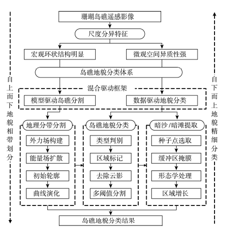
Fig. 1 General dual-scale transferred framework for coral island geomorphologic information extraction applying hybrid model-data driven technique图1 双尺度转化下混合驱动的珊瑚岛礁地貌遥感信息提取总体技术框架 |
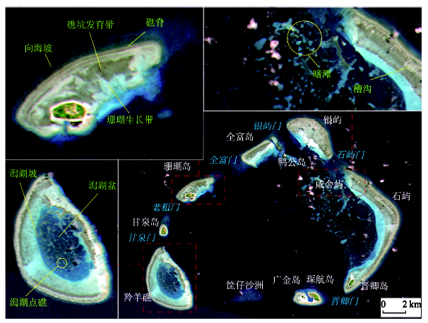
Fig. 2 CBERS-02B image for Yongle Atoll (imaging time: 2008.06.11; band combination: R3G2B1)图2 西沙永乐环礁CBERS-02B遥感影像(成像时间:2008年6月11日;波段组合:R3G2B1) |
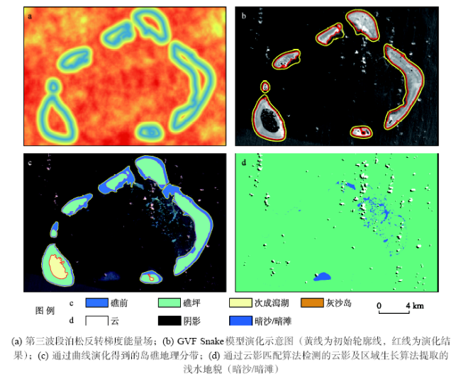
Fig. 3 Illustration for coral island geomorphology classification technique图3 岛礁地貌分类关键技术示意 |
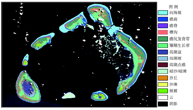
Fig. 4 Geomorphology classification map for Yongle Atoll图4 永乐环礁遥感信息提取结果 |
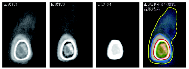
Fig. 5 Comparison of imaging capacity of different bands in CBERS-02B data图5 CBERS-02B影像波段成像能力差异比较 |
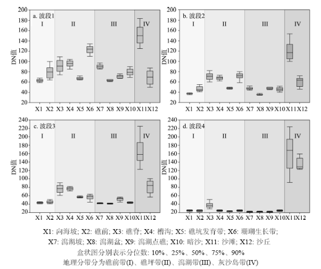
Fig. 6 DN value distribution of geomorphologic structures图6 地貌类型像元值分布图 |
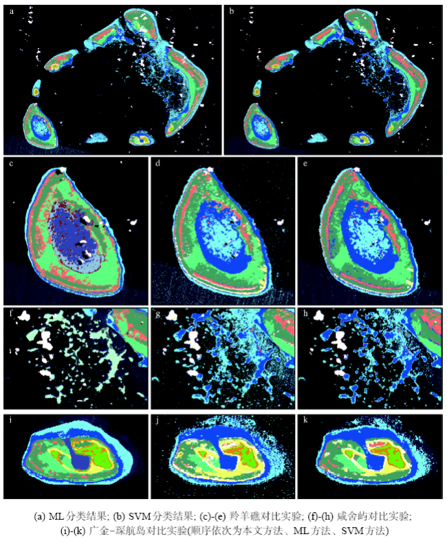
Fig. 7 Supervised classification methods for comparison图7 监督分类算法对比实验 |
The authors have declared that no competing interests exist.
| [1] |
[
|
| [2] |
|
| [3] |
|
| [4] |
|
| [5] |
|
| [6] |
|
| [7] |
|
| [8] |
|
| [9] |
|
| [10] |
|
| [11] |
|
| [12] |
|
| [13] |
|
| [14] |
|
| [15] |
|
| [16] |
|
| [17] |
|
| [18] |
|
| [19] |
|
| [20] |
|
| [21] |
|
| [22] |
|
| [23] |
|
| [24] |
|
| [25] |
|
| [26] |
|
| [27] |
|
| [28] |
|
| [29] |
|
| [30] |
|
| [31] |
|
| [32] |
[
|
| [33] |
[
|
| [34] |
[
|
| [35] |
[
|
| [36] |
[
|
| [37] |
[
|
| [38] |
|
| [39] |
|
| [40] |
|
| [41] |
|
| [42] |
[
|
| [43] |
[
|
| [44] |
|
| [45] |
|
| [46] |
|
| [47] |
|
| [48] |
|
| [49] |
|
| [50] |
[
|
| [51] |
[
|
/
| 〈 |
|
〉 |