
巴西热带雨林森林景观转化时空特征及破碎化分析
作者简介:宁静(1978- ), 女, 黑龙江哈尔滨人, 博士, 副教授, 研究方向为土地生态环境问题及3S技术应用。E-mail:njing_today@163.com
收稿日期: 2014-12-21
要求修回日期: 2015-04-29
网络出版日期: 2015-08-08
基金资助
国家“863”计划项目(2013AA122802)
中国科学院重点战略部署课题(KSZD-EW-Z-021-02)
国家重点基础研究发展计划(973计划)项目(2014CB954302)
国家自然科学基金项目(41201183)
Transformation and fragmentation of tropical rainforest landscape in Brazil
Received date: 2014-12-21
Request revised date: 2015-04-29
Online published: 2015-08-08
Copyright
巴西热带雨林地区森林景观转化及破碎化导致森林生态系统的功能和区域环境发生变化,并引起全球范围内的关注。以欧洲太空局全球土地利用/土地覆被数据和Landsat解译数据为基础,利用热点提取、信息熵、地统计分析模型及轨迹分析的方法探讨不同砍伐阶段森林破碎性的变化特点以及森林破碎化与整个区域景观格局变化的相关性。结果表明:① 热带雨林地区的森林面积迅速减少,其中,Rondonia州、Maton Grosso州和Para州最为典型。② 森林破碎性的变化趋势并非整体性的增加或减少,而是出现明显的局地性特点;③ 森林砍伐的数量与土地系统的信息熵呈正相关,即森林的数量及质量直接决定巴西热带雨林地区的土地系统稳定性。
宁静 , 杜国明 , 孟凡浩 , 匡文慧 , 闫凤丽 , 张英秀 . 巴西热带雨林森林景观转化时空特征及破碎化分析[J]. 地理研究, 2015 , 34(7) : 1235 -1246 . DOI: 10.11821/dlyj201507004
It arouses attention that the transformation and fragmentation of the Brazilian tropical rainforest has caused great changes in its ecosystem and environment as well as in forest cover. The forest fragmentation changes the function of forest ecological system and regional environment in Brazilian tropical rainforest, which attracts global attention. In this paper, the authors used ESA global land use/land cover data and Landsat interpreted data, as well as scientific methods such as hotspot extraction, information entropy, statistical analysis model and trajectory analysis to explore the relationship between change features of forest fragmentation in different deforestation stages and changes in forest fragmentation and regional landscape pattern. The results showed that: (1) The area of forest decreased rapidly in the tropical rainforest, among which Rondonia State, Maton Grosso State and Para State were the most typical; (2) The changing trend of forest fragmentation was not holistically increased or decreased, but represented a obvious regional pattern; (3) There was positive correlation between the number of deforestation and land system information entropy, namely the quantity and quality of forest directly determined the stability of the land system in Brazil's tropical rainforest.
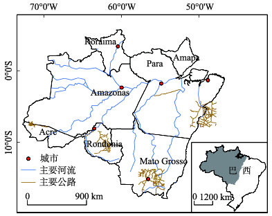
Fig. 1 Location of the reserch area图1 研究区位置示意图 |
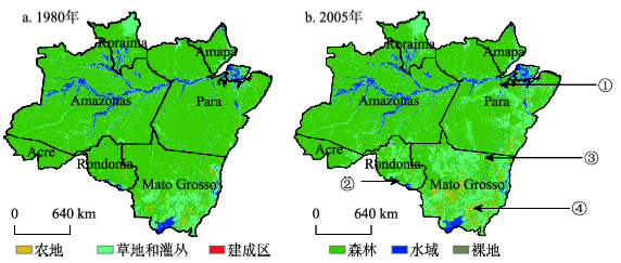
Fig. 2 Land use map of the research area in 1980 and 2005图2 1980年和2005年土地利用类型及森林砍伐严重区域位置示意图 |
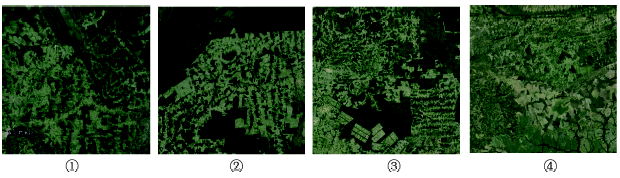
Fig. 3 Remote sense images of deforestation areas图3 森林砍伐严重区域的Landsat ETM遥感影像图 |
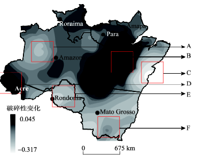
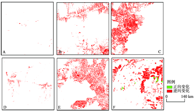
Fig. 4 Fragmentation change maps from 1980 to 2005图4 1980-2005年研究区破碎性变化及重点区域位置示意图 |
Tab. 1 Changes of forest fragmentation in hotspots表1 热点区森林破碎性变化表 |
| A | B | C | D | E | F | |
|---|---|---|---|---|---|---|
| 1980年 | 0.912 | 0.946 | 0.982 | 0.926 | 0.935 | 0.935 |
| 2005年 | 0.892 | 0.957 | 0.873 | 0.956 | 0.933 | 0.936 |
| 变化值 | -0.031 | 0.011 | -0.109 | 0.029 | -0.002 | 0.001 |
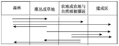
Fig. 5 Definition and classification of the changing trajectory in hotspots图5 热点区变化轨迹界定及分类 |
Fig. 6 Landscape change trajectory in hotspots图6 热点区景观变化轨迹图 |
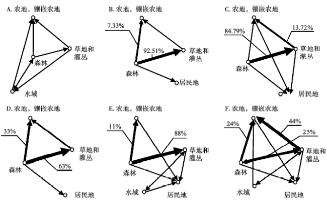
Fig. 7 Network of land-use transfer in hotspots图7 热点区土地利用转移网络图 |
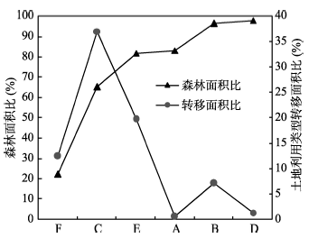
Fig. 8 Curve chart of forest area ratio and transfer area ratio图8 森林面积比和转移面积比曲线图 |
Tab. 3 Comparison on change of information entropy in hotspots表3 热点区信息熵变化比较表 |
| A | B | C | D | E | F | |
|---|---|---|---|---|---|---|
| 破碎性差值 | -3.12 | 1.09 | -10.91 | 2.94 | -0.16 | 0.10 |
| 信息熵 | -0.207 | 17.257 | 8.915 | 0.367 | 0.186 | 0.182 |
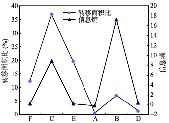
Fig. 9 Line chart of transfer area ratio and information entropy图9 转移面积比和信息熵折线图 注:破碎性差值指1980年与2005年森林破碎性的差值 |
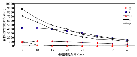
Fig. 10 Relationship between road and deforestation图10 道路与森林砍伐面积关系 |
The authors have declared that no competing interests exist.
| [1] |
|
| [2] |
[
|
| [3] |
|
| [4] |
|
| [5] |
|
| [6] |
|
| [7] |
|
| [8] |
|
| [9] |
|
| [10] |
|
| [11] |
|
| [12] |
|
| [13] |
|
| [14] |
|
| [15] |
|
| [16] |
|
| [17] |
|
| [18] |
|
| [19] |
|
| [20] |
|
| [21] |
|
| [22] |
|
| [23] |
|
| [24] |
|
| [25] |
|
| [26] |
|
| [27] |
|
| [28] |
[
|
| [29] |
[
|
| [30] |
[
|
| [31] |
[
|
| [32] |
[
|
| [33] |
|
| [34] |
[
|
| [35] |
|
| [36] |
|
| [37] |
[
|
/
| 〈 |
|
〉 |