
圣保罗大都市区社会空间分异研究——多元统计方法在城市连绵区的应用
作者简介:Reinaldo Paul Pérez Machado(1955-),男,副教授,研究方向为制图学、地理信息学和遥感。E-mail: rpmgis@usp.br
收稿日期: 2016-03-05
要求修回日期: 2016-05-23
网络出版日期: 2016-07-26
基金资助
国家社会科学基金重大项目(14ZDA026)
Social cartography of São Paulo Metropolitan Area: A multivariate analysis applied to the urban continuum
Received date: 2016-03-05
Request revised date: 2016-05-23
Online published: 2016-07-26
Copyright
空间数据和地理信息系统在城市规划和决策中应用的重要性日见凸显。主要原因在于:重要的人口数据和社会变动经常表现出一定的空间特性,这种特性可以通过空间分析和统计方法被认识和解释。应用多元分析的空间分类方法编制圣保罗大都市区社会分异地图并进行相关分析。研究的主要数据来自2000年巴西全国人口普查,其中包括了圣保罗大都市的所有行政区和39个自治市的21774个人口普查区。为了把都市连绵区从数据全集中分离出来,我们采用混合技术进行互补分析,即在2000年4月30日的陆地卫星7号图像中绘制一个个多边形,这些被识别出来的多边形就是人口普查区。然后,通过目视解译出假彩色多边形集合。应用空间分类评分程序将这些多边形分成五类,并建立人口普查区的数目、覆盖的面积和都市连绵区之间的关系。这种多元分析方法是基于变量的均衡化来生成易于用分级统计图描述平均值,以促进可视化和后续的空间分布分析。基于多元分析的空间分类方法研究,清楚地展现了圣保罗大都市最重要的社会特征,也说明城市社会地图方法和多元分析的空间分类方法在大都市区的管理、公共政策规划和复杂决策中具有重要的应用价值。
ReinaldoPaulPérezMachado , ViolêtaSaldanhaKubrusly , Ligia Vizeu Barrozo , 陈明玉 , 顾朝林 . 圣保罗大都市区社会空间分异研究——多元统计方法在城市连绵区的应用[J]. 地理研究, 2016 , 35(7) : 1370 -1382 . DOI: 10.11821/dlyj201607012
The use of spatial data and Geographic Information Systems is becoming more and more important to urban planning and decision-making. This occurs because important demographic data and social variation often show a spatial expression which can be understood through spatial analysis and statistical methods. Thus, the purpose of this study was to create and analyze the social map of Sao Paulo Metropolitan Area (SPMR) by applying the methodology of spatial classification by multivariate analysis. The primary data source employed in this work was the Brazilian National Census from the year 2000. It contained 21774 census tracts, which were aggregated into districts and 39 municipalities. Next, aiming to separate the urban continuum from the data universe we used a mixed technique to yield a complementary analysis: the drawing of a polygon through visual interpretation over a false color composite from the Landsat 7 image (ETM+), from April 30, 2000. The census tracts that were totally contained on the above-mentioned polygon were then identified and selected for visualization. For the analysis, the procedure went through Spatial Classification Scores-SCSs, in five categories, establishing a relationship between the number of census tracts, occupied surface and urban continuum. This simple multivariate analysis is based on the equalization of the variables, leading to the creation of an average score that is easily depicted with choropletic maps, thus facilitating visualization and consequent analysis of its spatial distribution. Finally, the Unified Spatial Classification Score (USCS) was created to integrate all the variables. Due to the results obtained in this research it is concluded that the method of spatial classification by multivariate analysis used here, clearly represent the peculiarities of the most important social variables on the urban agglomerate of the city of São Paulo. Finally, it is possible to highlight that urban social cartography, and the methodology of spatial classification by multivariate analysis are tools of undeniable value for managing and planning public policies and complex decision making in big cities and metropolitan areas.
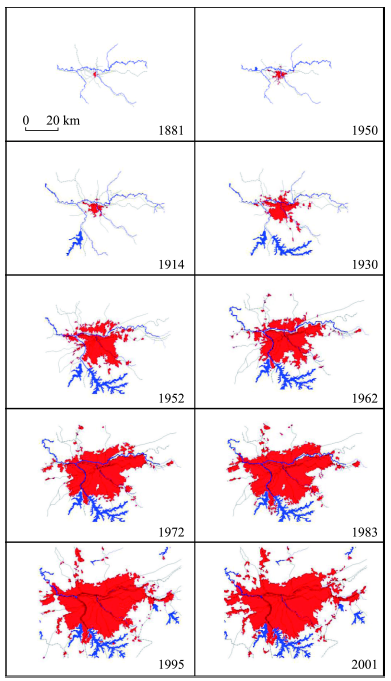
Fig. 1 Development of the urban spot corresponding to São Paulo Metropolitan图1 圣保罗大都市区的发展 |
Fig. 2 Map showing the population density in the municipality of São Paulo in 2000图2 2000年圣保罗市行政区和人口密度图 |
Tab. 1 A list containing the 31 submunicipalities, the administrative divisions of the municipality of São Paulo表1 2000年圣保罗市行政区划简表 |
| 缩写 | 行政区名称 | 人口数(人) |
|---|---|---|
| AF | 阿里坎杜瓦Aricanduva | 266838 |
| BT | 布坦塔Butantã | 377576 |
| CL | 坎普林波Campo Limpo | 505969 |
| CV | 卡萨佛德Casa Verde/Cachoeirinha | 313323 |
| AD | 德玛尔城Cidade Ademar | 370797 |
| CT | 蒂拉登特斯Cidade Tiradentes | 190657 |
| EM | 马塔拉佐Ermelino Matarazzo | 204951 |
| FO | 汤森自治镇/Freguesia/Brasilândia | 392251 |
| GU | 圭亚那Guaianazes | 256319 |
| IP | 伊皮兰加Ipiranga | 429235 |
| IT | 伊塔保利斯塔Itaim Paulista | 359215 |
| IQ | 伊塔克拉Itaquera | 489502 |
| JA | 贾巴尔普尔Jabaquara | 214095 |
| LA | 莱普Lapa | 270656 |
| MB | 博伊米林M'boi Mirim | 484966 |
| MO | 摩卡Moóca | 308161 |
| PA | 帕雷罗斯区Parelheiros | 111240 |
| PE | 佩尼亚Penha | 475879 |
| PR | 秘鲁Perus | 109116 |
| PI | 皮涅鲁斯Pinheiros | 272574 |
| PJ | 皮里图巴Pirituba | 390530 |
| ST | 圣安娜Santana/Tucuruvi | 327135 |
| SA | 圣安德烈Santo Amaro | 218558 |
| CP | 索科鲁Socorro | 563922 |
| SM | 马特乌斯São Mateus | 381718 |
| MP | 圣米格尔São Miguel | 378438 |
| SE | 圣保罗中心Sé | 373914 |
| JT | 杰卡纳区Tremembé/Jaçanã | 255612 |
| MG | 维拉玛丽亚Vila Maria/Vila Guilherme | 304393 |
| VM | 维拉马里亚纳Vila Mariana | 313036 |
| VP | 维拉普鲁登特Vila Prudente/Sapopemba | 523676 |
说明:本表包含了圣保罗市31个市辖区的缩写、行政区名和人口数。 |
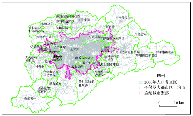
Fig. 3 The 39 municipalities of São Paulo Metropolitan Area图3 用于城市社会地图的圣保罗大都市区基础单元图 |
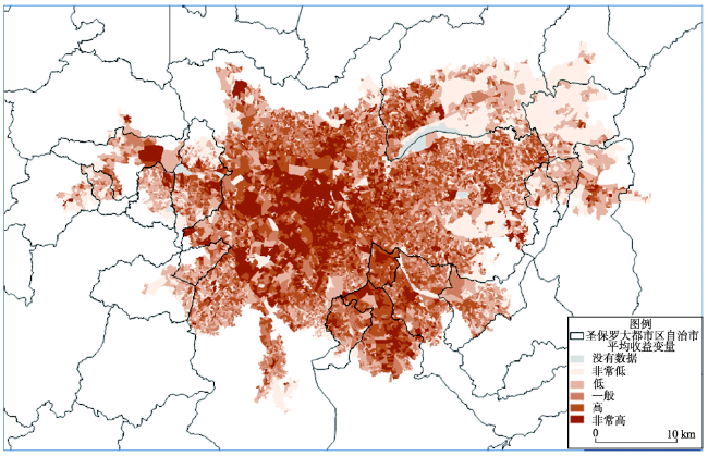
Fig. 4 Social map of São Paulo Metropolitan Area: Scoring of spatial classification of benefit (SSCB)图4 圣保罗大都市区社会地图——收益的空间分类评分(SSCB) |
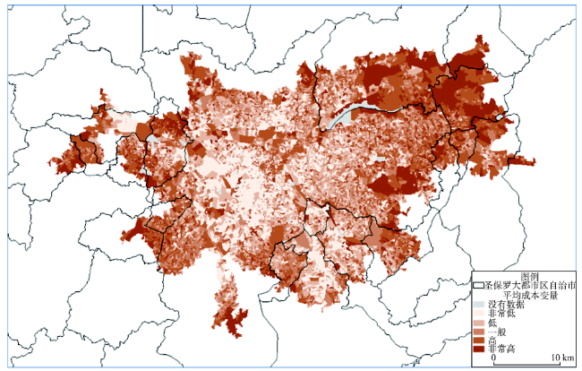
Fig. 5 Social map of São Paulo Metropolitan Area: Scoring of spatial classification of cost (SSCC)图5 圣保罗大都市区的社会地图——成本空间分类的评分(SSCC) |
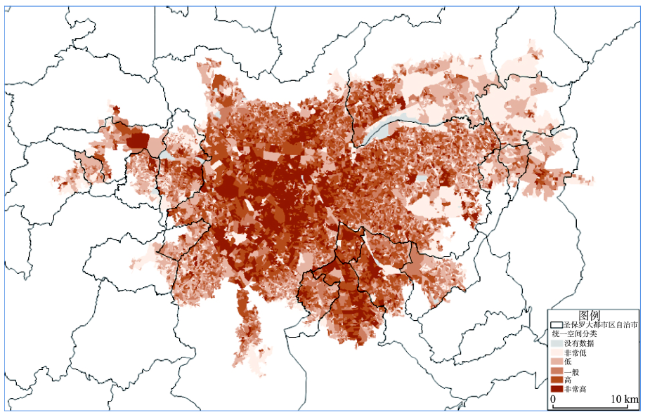
Fig. 6 Social map of the continuous urban spot of São Paulo Metropolitan Area: Unified Spatial Classification Scoring (USCS)图6 圣保罗大都市区连续城市聚落的社会分异图(USCS) |
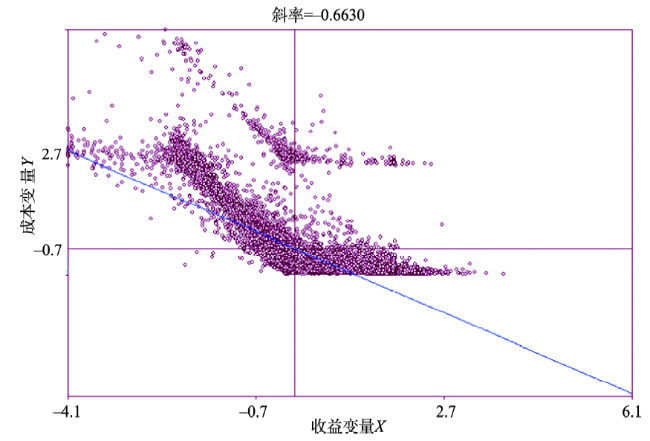
Fig. 7 Scatter plotting of SSCB and SSCC data图7 SSCB和SSCC数据的散点图 |
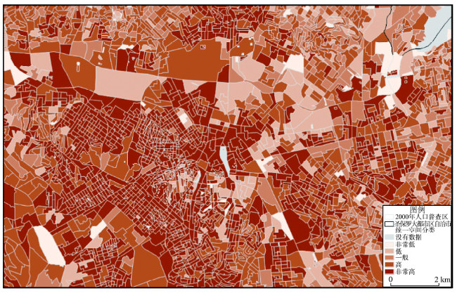
Fig. 8 Magnified detail of the central portion of the map in Figure 7图8 基于USCS圣保罗大都市区城市社会空间图 |
The authors have declared that no competing interests exist.
| [1] |
United Nations. World Urbanization Prospects.The 2011 Revision. New York: United Nations Economic & Social Affairs, 2012.
|
| [2] |
United Nations. World Urbanization Prospects.The 2007 Revision. New York: United Nations Economic & Social Affairs, 2008.
|
| [3] |
|
| [4] |
|
| [5] |
|
| [6] |
IBGE. Primeiros Resultados do Censo Demográfico 2010. Diário Oficial da União de 04 de Novembro de 2011. Brasília: Instituto Brasileiro de Geografia e Estatística, 2011.
|
| [7] |
|
| [8] |
|
| [9] |
|
| [10] |
IBGE. Censo Demográfico 2000: Agregado por Setores Censitários dos Resultados do Universo. Rio de Janeiro: Instituto Brasileiro de Geografia e Estatística, 2003, 157: 2.
|
| [11] |
|
| [12] |
INDEC. El estudio de la pobreza según el Censo Nacional de Población, Hogares y Viviendas 2001: El Indice de Privación Material de los Hogares (IPMH). Desarrollo de Nuevas Metodologías para el estudio de la pobreza con datos censales. Documento de Trabajo N° 61. Buenos Aires: Instituto Nacional de Estadística y Censos, 2003.
|
| [13] |
|
| [14] |
|
| [15] |
|
| [16] |
|
| [17] |
|
| [18] |
|
/
| 〈 |
|
〉 |
