
首套全球30 m分辨率土地覆被产品区域尺度精度评价——以河南省为例
作者简介:黄亚博(1982- ),女,河南开封人,博士研究生,讲师,主要从事遥感地学应用研究。E-mail: hyb@henu.edu.cn
收稿日期: 2016-03-23
要求修回日期: 2016-05-27
网络出版日期: 2016-08-29
基金资助
国家科技基础性工作专项(2012FY111800)
河南省高等学校重点科研项目(16A520081)
中国科学院战略性先导科技专项(XDA05050000)
Regional accuracy assessments of the first global land cover dataset at 30-meter resolution: A case study of Henan province
Received date: 2016-03-23
Request revised date: 2016-05-27
Online published: 2016-08-29
Copyright
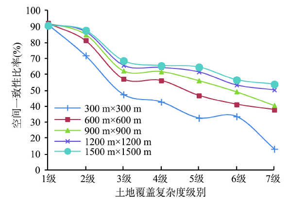
以河南省为研究区,对全球首套30 m分辨率土地覆盖产品GlobleLand30进行区域尺度精度评价。首先,以中国110万土地利用数据(CHINA-2010)为参考,分析两种产品的空间一致性;而后,通过Google Earth样本分析GlobleLand30在空间不一致区域的制图精度;最后,利用野外实地考察样本对GlobleLand30进行总体精度评价,并从土地覆被复杂度、高程等方面分析影响精度的原因,结果表明:① GlobleLand30与CHINA-2010空间一致性达80.20%。两种产品对耕地、林地、人工地面一致性高,对草地、水体、灌木、湿地、未利用土地的一致性低。② 在空间不一致区域,GlobleLand30的总体分类正确率略低于CHINA-2010,但两者对不同地类的优势不同。③ 经野外实地考察验证可知,GlobleLand30的总体精度达83.33%。④GlobleLand30与CHINA-2010的空间一致性随土地覆被复杂度的增加而降低,并在高程过渡带较低。
关键词: 土地利用/土地覆被; 精度评价; 空间一致性; 30 m分辨率; GlobleLand30
黄亚博 , 廖顺宝 . 首套全球30 m分辨率土地覆被产品区域尺度精度评价——以河南省为例[J]. 地理研究, 2016 , 35(8) : 1433 -1446 . DOI: 10.11821/dlyj201608003
Accurate global land cover datasets are key environmental information for research on global changes and regional sustainable development, such as global climate change, ecosystem assessment, biodiversity conservation. However, there are still some shortcomings in showing spatial and thematic details for the existing global land cover products at medium and low resolutions (300-1000 m). Recently, GlobeLand30, a global land cover product based on Landsat images at a 30-m resolution, was produced and released by China. The product made a breakthrough in enhancing spatial resolution of global land cover products, and has a wide range of application prospects. As with any land cover products, it is necessary to carry out accuracy evaluation of GlobeLand30 in global, regional or local scales before it is widely applied. This study aims at assessing the accuracy of GlobleLand30 in Henan province with cross-comparison analyses and sampling methods respectively. Firstly, the national land use database of China at a 1100000 scale (CHINA-2010) was used as a reference data to analyze the spatial consistency between these two products. Secondly, validation samples collected from Google Earth were used to assess the producer's accuracy in spatially inconsistent areas. Finally, the overall accuracy of GlobleLand30 was assessed by field survey. Moreover, several factors influencing the accuracy of GlobleLand30 were also taken into consideration, such as land cover complexity and elevation. The following conclusions were drawn: (a) Spatial consistency between GlobleLand30 and CHINA-2010 reached up to 80.20%. There was high spatial consistency for croplands, forests and artificial surfaces, and low spatial consistency for grasslands, water bodies, shrubs, wetlands and unused lands. (b) The overall accuracy of GlobleLand30 was slightly lower than that of CHINA-2010 in spatially inconsistent areas. As for forests, producer's accuracy of GlobleLand30 was relatively higher than that of CHINA-2010. (c) It was found by field survey that the overall accuracy of GlobleLand30 was 83.33%. (d) On the one hand, with the increase of the complexity of land cover types, spatial consistency between GlobleLand30 and CHINA-2010 decreased; on the other hand, with the increase of elevation, spatial consistency between the two products decreased first and then rose, and became lower in the elevation transition zones.
Tab. 1 Characteristics of GlobleLand30 and CHINA-2010表1 GlobleLand30和CHINA-2010的特征 |
| 产品特征 | GlobleLand30 | CHINA-2010 |
|---|---|---|
| 输入数据 | Landsat TM/ETM+、HJ-1、生态区划等 | Landsat TM/ETM+、HJ-1、地形图等 |
| 数据时相 | 2010基准年 | 2010基准年 |
| 分类方法 | 像素分类—对象提取—知识检核 | 目视解译 |
| 数据格式 | 栅格 | 矢量 |
| 空间尺度 | 30 m分辨率 | 110万比例尺 |
| 空间范围 | 全球 | 中国 |
| 投影 | WGS84坐标系、UTM投影 | GCS Krasovsky 1940 坐标系、Albers 投影 |
| 制图单位 | 国家基础地理信息中心等 | 中国科学院资源环境科学数据中心 |
Tab. 2 Corresponding relationships of types in different land cover classification system表2 不同土地覆被分类系统间的类别对应关系 |
| 统一类别 | GlobleLand30 | CHINA-2010 |
|---|---|---|
| 1 耕地 | 10 农业、园艺用地 | 11 水田 12 旱地 |
| 2 林地 | 20 覆盖度>30%和10%~30%的林地 | 21 有林地 23 疏林地 24 其他林地 |
| 3 草地 | 30 覆盖度>10%,以自然草地覆盖为主 | 31 高覆盖度草地 32 中覆盖度草地 33 低覆盖度草地 |
| 4 灌木 | 40 覆盖度>30%的灌木林 | 22 灌木林 |
| 5 湿地 | 50 湿地植物和湿地水体 | 64 沼泽地 45 滩涂 46 滩地 |
| 6 水体 | 60 内陆水体 | 41 河渠 42 湖泊 43 水库坑塘 |
| 7 未利用土地 | 70 苔原90 裸地 | 61 沙地 62 戈壁 63 盐碱地65 裸土地 66 裸岩石砾地 67 其他 |
| 8 人工地面 | 80 由人类活动造成的土地改变 | 51 城镇用地 52 农村居民点 53 其他建设用地 |
| 9 永久冰雪 | 100 终年积雪、冰川 | 44 永久性冰川雪地 |
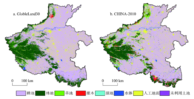
Fig. 1 GlobleLand30 and CHINA-2010 with a common land cover classification system图1 采用统一分类系统的GlobleLand30与CHINA-2010 |
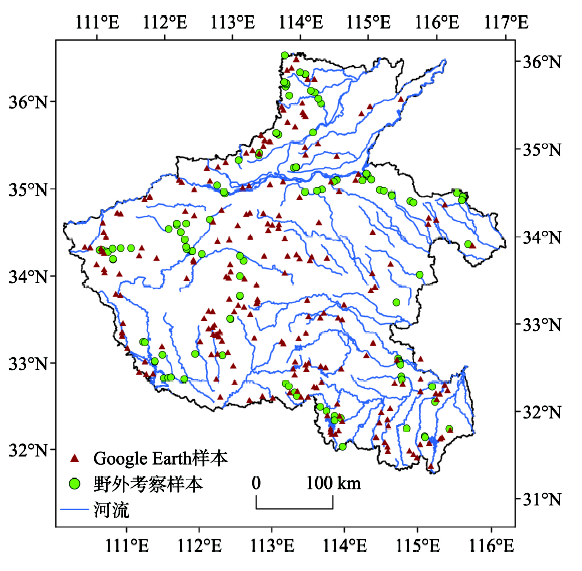
Fig. 2 The distribution of validation samples from field survey and Google Earth图2 野外考察样本及Google Earth样本分布 |
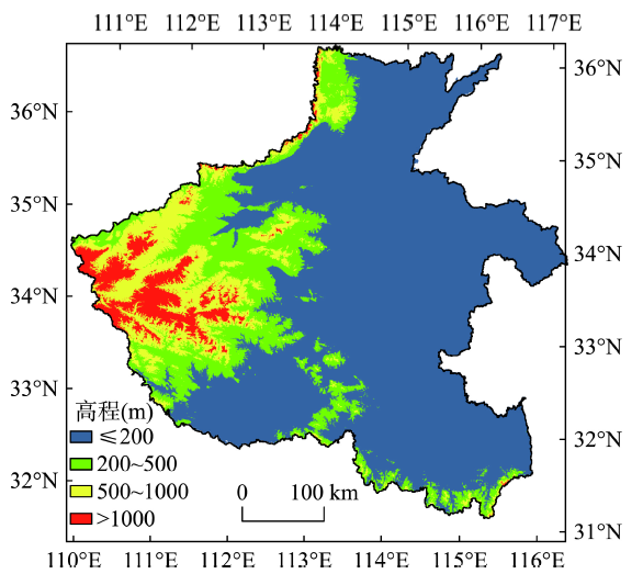
Fig. 3 Zoning map of elevation in the study area图3 研究区高程分带图 |
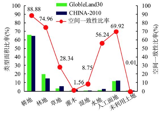
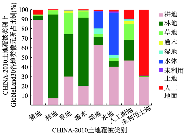
Fig. 4 Area ratio and spatial consistency ratio of land cover types图4 土地覆被类别面积比率与空间一致性比率 |
Fig. 5 Confusion of land cover types between GlobleLand30 and CHINA-2010图5 GlobleLand30和CHINA-2010土地覆被类别混淆 |
Tab. 3 Google Earth validation samples in spatially inconsistent areas表3 空间不一致区域Google Earth验证样本 |
| 混淆地类名称 | 面积(km2) | 样本个数 |
|---|---|---|
| 耕地—人工地面 | 10973.66 | 82 |
| 耕地—林地 | 6192.77 | 46 |
| 耕地—草地 | 3945.84 | 30 |
| 草地—林地 | 5006.21 | 37 |
| 耕地—水体 | 1617.98 | 12 |
| 灌木—林地;灌木—耕地; 灌木—草地 | 3475.79 | 26 |
| 合计 | 31212.25 | 233 |
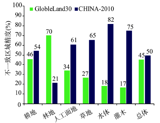
Fig. 6 Producer's accuracy and overall accuracyin spatially inconsistent areas图6 空间不一致区域的制图精度与总体精度 |
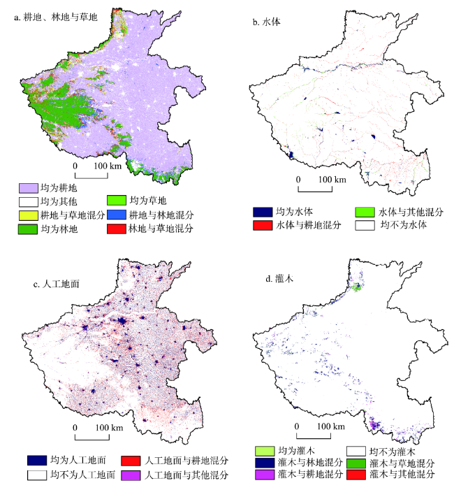
Fig. 7 Spatial distributions of confusion for main land cover types图7 主要土地覆被类别混淆的空间分布 |
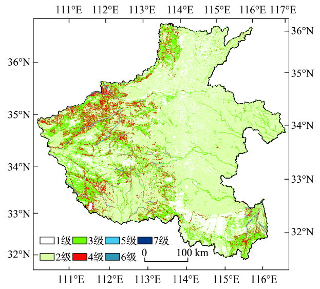
Fig. 8 Hierarchical map of land cover图8 土地覆被复杂度分级图(1200 m×1200 m) |
Fig. 9 Spatial consistency at different land cover complexity levels图9 不同土地覆被复杂度级别的空间一致性 |
Tab. 4 Spatial consistency at different elevation zones表4 不同高程带的空间一致性 |
| 高程带(m) | 200 | 200~500 | 500~1000 | 1000 |
|---|---|---|---|---|
| 面积(km2) | 111794 | 27927 | 17596 | 7996 |
| 一致性比率(%) | 85.56 | 63.81 | 69.69 | 85.57 |
| 优势地类 | 耕地>人工地面>水体 | 耕地>林地>草地>灌木 | 林地>耕地>草地>灌木 | 林地为主 |
| 主要混淆地类 | 耕地—人工地面 | 耕地—林地—草地—灌木 耕地—人工地面 | 耕地—林地—草地—灌木 | 林地—草地 |
The authors have declared that no competing interests exist.
| [1] |
|
| [2] |
|
| [3] |
|
| [4] |
[
|
| [5] |
[
|
| [6] |
[
|
| [7] |
|
| [8] |
|
| [9] |
[
|
| [10] |
[
|
| [11] |
[
|
| [12] |
|
| [13] |
|
| [14] |
[
|
| [15] |
|
| [16] |
|
| [17] |
[
|
| [18] |
[
|
| [19] |
|
| [20] |
|
| [21] |
|
| [22] |
|
| [23] |
[
|
| [24] |
|
| [25] |
|
| [26] |
[
|
| [27] |
[
|
| [28] |
[
|
| [29] |
[
|
/
| 〈 |
|
〉 |