
长春市各级交通路线对城市功能用地变化的作用效应关系研究
作者简介:马佐澎(1989- ),男,山东潍坊人,博士研究生,主要研究方向为城市地理与城市规划。E-mail: mazp841@nenu.edu.cn
收稿日期: 2016-03-09
要求修回日期: 2016-07-18
网络出版日期: 2016-09-10
基金资助
国家自然科学基金项目(41171103)
中央高校基本科研业务费专项资金(2412015KJ022)
The relationship between different types of traffic route and functional urban land use in Changchun
Received date: 2016-03-09
Request revised date: 2016-07-18
Online published: 2016-09-10
Copyright
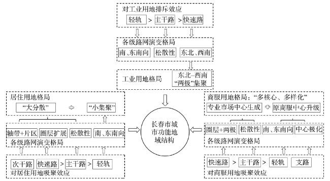
利用长春市中心城区2003年、2013年土地利用现状图,运用廊道效应原理与ArcGIS空间分析功能,揭示了交通系统“快速化”背景下长春市各级交通路线对城市功能用地演替的作用效应关系。研究发现:轻轨、主干路、快速路对商服用地的吸聚效应依次增强,快速路沿线商服用地主要用于专业化市场建设,轻轨沿线商服用地用作综合性商场开发;快速路对沿线居住用地吸聚强度大于主干路,轻轨对沿线居住用地具有近距离排斥效应;在市中心区,快速路、主干路、轻轨对工业用地的排斥强度依次增强,但随着由中心至外围的过渡,快速路的排斥效应将转化为吸聚效应。各级交通路线对沿线城市功能用地作用效应的差异性,一定程度上推动了长春市城市地域结构的演变。
马佐澎 , 李诚固 , 张婧 , 申庆喜 , 周国磊 , 冯铁宇 . 长春市各级交通路线对城市功能用地变化的作用效应关系研究[J]. 地理研究, 2016 , 35(9) : 1687 -1700 . DOI: 10.11821/dlyj201609008
The land status maps covering the years 2003-2013 provide the main data for this article. With the help of corridor effect theory and ArcGIS analysis tools, the paper studies the relationship between different traffic routes and urban land use against a backdrop of a rapidly expanding traffic system. The research revealed the following: light rail, trunk roads and expressways attract commercial land usage along traffic routes, and this, in turn, intensifies and exacerbates that attraction. Commercial land along expressways is mainly used for the construction of specialized markets. Commercial lands along light rail routes are used for the construction of comprehensive shopping malls. Trunk roads going to residential areas have less commercial appeal. Similarly light rail routes to residential areas tend to have a repulsion effect on commercial usage. In city center areas, expressways, trunk roads and light rail exclude industrial lands along traffic routes, and this, in its turn, further intensives the exclusion effect. However, with the transition from the center to the periphery, the current repulsion effect of expressways will be converted to an attraction effect. These differences in the effects of traffic routes on urban land use contribute to the evolution of Changchun city's urban area structure.
Key words: traffic routes; lands for urban functions; change; effects of action; Changchun
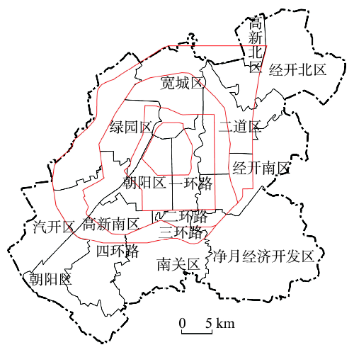
Fig. 1 Sketch map of Changchun city center图1 长春市中心城区示意图 |
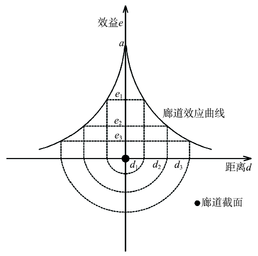
Fig. 2 Curve of corridor effect change with distances图2 廊道效益距离衰减曲线 |
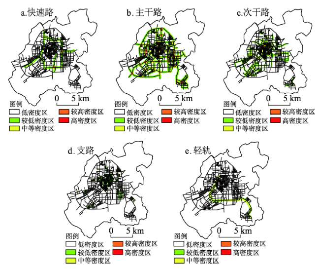
Fig. 3 The distribution pattern of line density of all kindsof traffic routes of Changchun in 2003图3 2003年长春市各级交通路线线密度分布格局 |
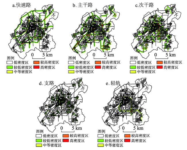
Fig. 4 The distribution pattern of line density of all kinds of traffic routes of Changchun in 2013图4 2013年长春市各级交通路线线密度分布格局 |
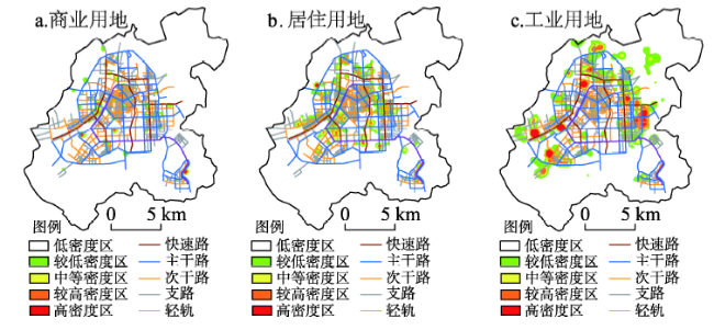
Fig. 5 The regional structure of commerce, residence and industry of Changchun in 2003图5 2003年长春市商业、居住、工业地域结构 |
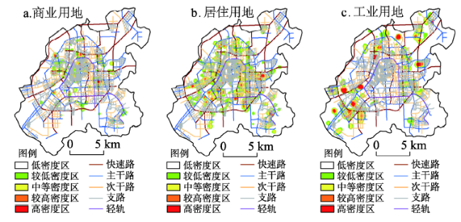
Fig. 6 The regional structure of commerce, residence and industry of Changchun in 2013图6 2013年长春市商业、居住、工业地域结构 |
Tab. 1 The correlation coefficient between road network density and urban land use nuclear density of Changchun in 2013表1 2013年长春市交通路网密度与城市功能用地核密度相关系数 |
| 土地类型 | 快速路 | 主干路 | 次干路 | 支路 | 轻轨 |
|---|---|---|---|---|---|
| 商业用地 | 0.1346 | 0.3190 | 0.2866 | 0.5031 | 0.0935 |
| 居住用地 | 0.1659 | 0.2383 | 0.4749 | 0.4795 | 0.2802 |
| 工业用地 | 0.0905 | 0.1363 | 0.1022 | 0.1224 | -0.1262 |
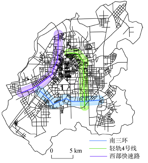
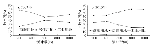
Fig. 7 Sketch map of light rail, expresswaysand trunk roads图7 轻轨、快速路、主干路位置示意图 |
Fig. 8 The spatial distribution of land use along LRT 4 in 2003 and 2013图8 2003-2013年轻轨4号线沿线土地利用空间分布 |
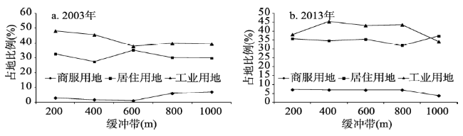
Fig. 9 The spatial distribution of land use along Expressway West in 2003 and 2013图9 2003-2013年西部快速路沿线土地利用空间分布 |
Fig. 10 The spatial distribution of land use along South Ring Road in 2003 and 2013图10 2003-2013年南环城路沿线土地利用空间分布 |
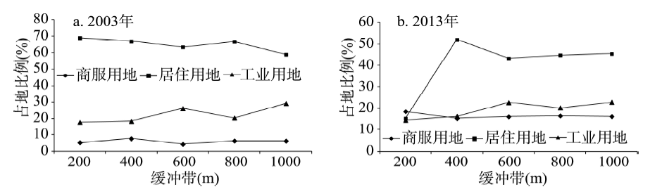
Tab. 2 The spatial differentiation's curve of land use along urban traffic routes in 2013表2 2013年城市交通路线沿线土地利用空间分异曲线 |
| 道路等级 | 土地类型 | 空间分异曲线 |
|---|---|---|
| 轨道交通 | 工业用地 | y =0.053ln(x)+0.1432 |
| 居住用地 | y =0.164ln(x)+0.2448 | |
| 商服用地 | y =-0.011ln(x)+0.1768 | |
| 快速路 | 工业用地 | y =0.024ln(x)+0.518 |
| 居住用地 | y =-0.096ln(x)+0.3827 | |
| 商服用地 | y =-0.019ln(x)+0.0436 | |
| 主干路 | 工业用地 | y =0.037ln(x)+0.3963 |
| 居住用地 | y =-0.021ln(x)+0.3615 | |
| 商服用地 | y =-0.014ln(x)+0.0772 |
Fig. 11 Sketch map of the relationship between traffic system and urban function areas图11 长春市交通系统与城市功能地域结构关系示意图 |
The authors have declared that no competing interests exist.
| [1] |
[
|
| [2] |
[
|
| [3] |
[
|
| [4] |
|
| [5] |
|
| [6] |
|
| [7] |
|
| [8] |
|
| [9] |
|
| [10] |
|
| [11] |
|
| [12] |
|
| [13] |
|
| [14] |
|
| [15] |
|
| [16] |
|
| [17] |
|
| [18] |
|
| [19] |
|
| [20] |
|
| [21] |
[
|
| [22] |
[
|
| [23] |
[
|
| [24] |
[
|
| [25] |
[
|
| [26] |
[
|
| [27] |
[
|
| [28] |
[
|
| [29] |
[
|
| [30] |
[
|
| [31] |
[
|
| [32] |
[
|
| [33] |
[
|
| [34] |
[
|
| [35] |
[
|
| [36] |
[
|
| [37] |
[
|
| [38] |
[
|
| [39] |
[
|
/
| 〈 |
|
〉 |