
重庆两江新区低丘缓坡开发建设生态适宜性评价
作者简介:蒋佳佳(1993-),女,重庆合川人,硕士,研究方向为土地资源管理。E-mail: jiangjj2019@163.com
收稿日期: 2018-01-10
要求修回日期: 2018-03-07
网络出版日期: 2019-06-12
基金资助
2015年度第二批国土房管科技计划项目(KJ-2015032)
Evaluation on ecological suitability for development and construction of gentle hillside in Liangjiang New Area
Received date: 2018-01-10
Request revised date: 2018-03-07
Online published: 2019-06-12
Copyright
低丘缓坡土地开发建设是协调城镇化和生态保护的重要途径。以重庆两江新区为例,首先界定研究区低丘缓坡土地评价范围,提取低丘缓坡土地面积共为531.66 km2。然后以生态保护为基本目标,从自然禀赋、区位条件、生态环境3个角度选取10个指标,应用生态适宜度模型建立低丘缓坡土地开发建设生态适宜度等级空间格局。结果表明:① 低丘缓坡土地开发建设单因子生态适宜性等级差异较大,其中自然禀赋和生态环境的生态适宜度等级以中高等级为主,区位条件的生态适宜度等级以中等级为主。② 研究区综合生态适宜度等级以中等级为主,以复盛、石船、鱼嘴和龙兴等地为集中适宜开发建设区。③ 通过综合生态适宜度等级与土地利用总体规划数据的叠加分析,将研究区划分为四类建设区。优先开发区面积为80.43 km2,集中在西部河流两岸附近1000 m和东部槽谷地区;一般开发区面积为157.26 km2,主要位于西部河流两岸250~350 m地带和铜锣山两侧槽谷地区;限制开发区面积为201.74 km2,集聚在中部400~450 m台地区;禁止开发区面积为92.22 km2,以“四山”地区为集中区。研究结果为低丘缓坡土地开发建设过程中经济发展和生态保护“双赢”策略的制定提供科学依据。
蒋佳佳 , 邵景安 , 谭少军 , 杜建平 . 重庆两江新区低丘缓坡开发建设生态适宜性评价[J]. 地理研究, 2019 , 38(6) : 1403 -1419 . DOI: 10.11821/dlyj020180035
Development and construction of gentle hillside land is regarded as an important way to coordinate urbanization and ecological protection. Taking Liangjiang New Area located in Chongqing as a case study, we defined the evaluation range of gentle hillside land in this study, which covers an area of 531.66 km2. Then, with ecological protection as the basic goal, ten indicators were selected from three perspectives of natural endowment, social condition and ecological environment, and the ecological suitability model was applied to build a spatial pattern for ecological suitability grade of gentle hillside land in the study area. The results were shown as follows: (1) The single-factor ecological suitability grade of development and construction for gentle hillside land differs greatly, among which the natural suitability and eco-environment ecological suitability grade were mainly middle-high grade and the location condition ecological suitability grade were mainly medium grade. (2) The comprehensive eco-suitability of the study area was medium grade, with Fusheng, Shijie, Yuzui and Longxing towns as centers for suitable development and construction. (3) Based on comprehensive ecological suitability grade and the land use planning data in Liangjiang New Area by ArcGIS, the study area was divided into four construction areas. The priority development zone covered an area of 80.43 km2, which was concentrated in the vicinity of 1000 meters on both sides of the western river, and the eastern trough area. Moderate development zone covered an area of 157.26 km2, mainly in the western rivers at an altitude of 250 to 350 m and on both sides of the groove Valley Tongluoshan. The area of the limited development zone was 201.74 km2, and gathered in the central platform area at an altitude of 400-450 m. The area of the prohibited development zone was 92.22 km2, with the "four mountains" as a concentrated area. Therefore, our results can provide a scientific basis for the "win-win" strategy of economic development and ecological protection and the reasonable development and construction of gentle hillside land.
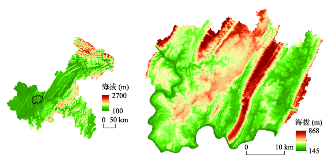
Fig. 1 Location of the study area图1 研究区的区位 |
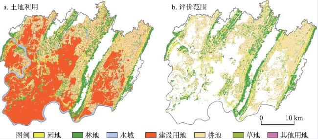
Tab. 1 Area and percentage of land use in Liangjiang New Area表1 两江新区土地利用面积与百分比 |
| 耕地 | 林地 | 园地 | 草地 | 水域 | 建设用地 | 其他用地 | |||||||||||||
|---|---|---|---|---|---|---|---|---|---|---|---|---|---|---|---|---|---|---|---|
| 面积 (km2) | 比例 (%) | 面积 (km2) | 比例 (%) | 面积 (km2) | 比例 (%) | 面积 (km2) | 比例 (%) | 面积 (km2) | 比例 (%) | 面积 (km2) | 比例 (%) | 面积 (km2) | 比例 (%) | ||||||
| 336.8 | 28.1 | 223.3 | 18.6 | 68.1 | 5.7 | 3.7 | 0.3 | 55.2 | 4.6 | 507.1 | 42.3 | 5.9 | 0.5 | ||||||
Fig. 2 Land use status and scope of ecological suitability evaluation of development and construction for gentle hillside in Liangjiang New Area图2 两江新区低丘缓坡的土地利用现状和开发建设生态适宜性评价范围 |
Tab. 2 Ecological suitability evaluation system and weight for development and construction of gentle hillside land表2 低丘缓坡土地开发建设生态适宜性评价体系及权重 |
| 准则层 | 指标层 | 原始数据 | 处理方法 | 选取依据 | 权重 |
|---|---|---|---|---|---|
| 自然禀赋 | 平均高程(m) | 90 mDEM、 土地利用变更数据 | 重采样15 mDEM—栅格转矢量—叠加分析 | 建设难易程度 | 0.016 |
| 平均坡度(°) | 90 mDEM、 土地利用变更数据 | 重采样15 mDEM—坡度提取—栅格转矢量—叠加分析 | 开发难易程度 | 0.221 | |
| 坡向/无量纲 | 90 mDEM、 土地利用变更数据 | 重采样15 mDEM—坡向提取—栅格转矢量—叠加分析 | 地块建设布局 | 0.025 | |
| 区位条件 | 距河流距离(m) | 河流数据、 土地利用变更数据 | 近邻分析 | 用水需求度 | 0.203 |
| 距交通干线距离(m) | 交通数据、 土地利用变更数据 | 近邻分析 | 地块通达度 | 0.203 | |
| 距城镇距离(m) | 城镇中心数据、 土地利用变更数据 | 近邻分析 | 经济辐射能力 | 0.072 | |
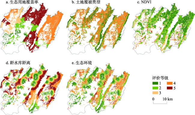
| 生态环境 | 生态用地[22]覆盖率(%) | 土地利用变更数据 | SQL字段筛选—统计分析 | 生态调适能力 | 0.035 |
| 土地覆被类型 | 土地利用变更数据 | 地块生态特征 | 0.060 | ||
| NDVI | LANDSAT 8影像 | NDVI值计算—重采样15 m分辨率 | 水土保持能力 | 0.024 | |
| 距水库距离(m) | 土地利用变更数据 | SQL字段筛选—近邻分析 | 生态敏感程度 | 0.141 |
Tab. 3 Characteristics of ecological suitability index and the basis for determining optimal niche for development and construction of gentle hillside land表3 低丘缓坡土地开发建设生态适宜度指标特征与最适生态位确定依据 |
| 指标层 | 指标 属性 | 指标 类型 | 最适生态位 确定依据 | 指标层 | 指标 属性 | 指标 类型 | 最适生态位 确定依据 |
|---|---|---|---|---|---|---|---|
| 平均高程 | – | Ⅲ | 数据标准化最小值 | 距城镇距离 | – | Ⅲ | 数据标准化最小值 |
| 平均坡度 | – | Ⅲ | 数据标准化最小值 | 生态用地覆盖率 | + | Ⅰ | 数据标准化最大值 |
| 坡向 | + | Ⅰ | 数据标准化最大值 | 土地覆被类型 | + | Ⅰ | 数据标准化最大值 |
| 距河流距离 | – | Ⅲ | 数据标准化最小值 | NDVI | – | Ⅲ | 数据标准化最小值 |
| 距交通干线距离 | – | Ⅲ | 数据标准化最小值 | 距水库距离 | <> | Ⅱ | 数据标准化平均值 |
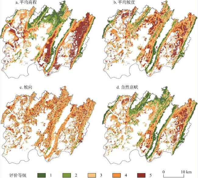
Fig. 3 Evaluation grade of ecological suitability for natural endowment图3 自然禀赋生态适宜度评价等级 |
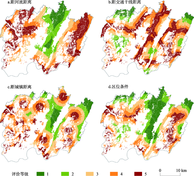
Fig. 4 Evaluation grade of ecological suitability for location condition图4 区位条件生态适宜度评价等级 |
Fig. 5 Evaluation grade of ecological suitability for ecological environment图5 生态环境生态适宜度评价等级 |
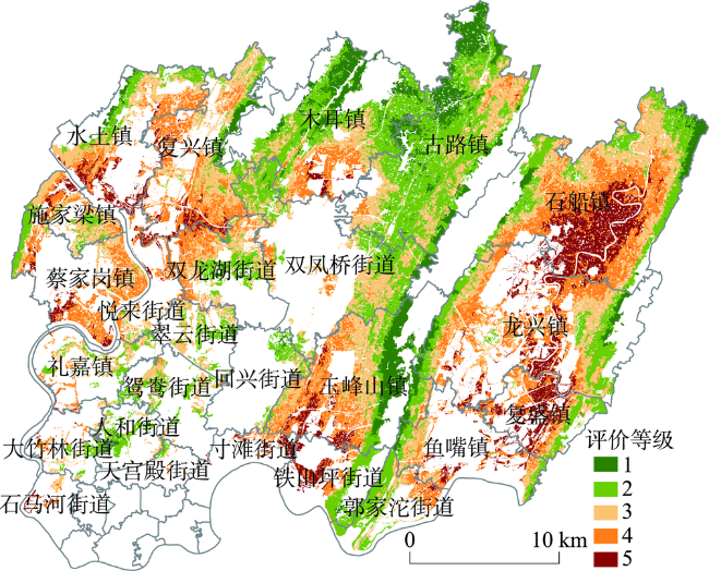
Fig. 6 Evaluation grade of comprehensive ecological suitability图6 综合生态适宜度评价等级 |
Tab. 4 Area and percentage of evaluation grade of ecological suitability for administrative unit表4 行政单元生态适宜度评价等级的面积及百分比 |
| 行政区名称 | 总面积 (km2) | 1级 | 2级 | 3级 | 4级 | 5级 | |||||||||
|---|---|---|---|---|---|---|---|---|---|---|---|---|---|---|---|
| 面积 (km2) | 比例 (%) | 面积 (km2) | 比例 (%) | 面积 (km2) | 比例 (%) | 面积 (km2) | 比例 (%) | 面积 (km2) | 比例 (%) | ||||||
| 研究区 | 531.66 | 51.48 | 9.68 | 164.56 | 30.95 | 151.54 | 28.50 | 114.58 | 21.55 | 49.51 | 9.32 | ||||
| 蔡家岗镇 | 17.80 | 0.02 | 0.09 | 2.45 | 13.75 | 4.50 | 25.25 | 9.15 | 51.38 | 1.69 | 9.52 | ||||
| 翠云街道 | 6.76 | 0.22 | 3.31 | 3.05 | 45.22 | 3.32 | 49.09 | 0.16 | 2.38 | 0.00 | 0.00 | ||||
| 寸滩街道 | 2.15 | 0.00 | 0.00 | 0.03 | 1.25 | 0.27 | 12.50 | 0.79 | 36.85 | 1.06 | 49.39 | ||||
| 大竹林街道 | 3.46 | 0.12 | 3.46 | 1.35 | 39.13 | 1.13 | 32.70 | 0.79 | 22.75 | 0.07 | 1.96 | ||||
| 复盛镇 | 15.77 | 0.06 | 0.35 | 3.08 | 19.50 | 2.56 | 16.24 | 4.79 | 30.36 | 5.29 | 33.55 | ||||
| 复兴镇 | 34.06 | 1.97 | 5.80 | 4.90 | 14.38 | 12.38 | 36.34 | 11.68 | 34.31 | 3.13 | 9.18 | ||||
| 古路镇 | 73.14 | 15.80 | 21.60 | 39.39 | 53.86 | 16.21 | 22.16 | 1.72 | 2.35 | 0.02 | 0.03 | ||||
| 郭家沱街道 | 11.00 | 0.01 | 0.05 | 6.42 | 58.38 | 2.29 | 20.79 | 2.04 | 18.53 | 0.25 | 2.24 | ||||
| 回兴街道 | 3.82 | 0.19 | 4.98 | 2.55 | 66.96 | 1.06 | 27.81 | 0.01 | 0.25 | 0.00 | 0.00 | ||||
| 礼嘉镇 | 7.06 | 0.02 | 0.30 | 2.45 | 34.65 | 3.10 | 43.96 | 1.25 | 17.72 | 0.24 | 3.37 | ||||
| 龙兴镇 | 52.76 | 2.83 | 5.36 | 11.70 | 22.17 | 15.38 | 29.15 | 16.53 | 31.33 | 6.33 | 11.99 | ||||
| 木耳镇 | 48.98 | 11.16 | 22.79 | 21.77 | 44.44 | 9.33 | 19.04 | 5.72 | 11.68 | 1.01 | 2.06 | ||||
| 人和街道 | 3.75 | 0.52 | 13.84 | 2.47 | 65.89 | 0.68 | 18.19 | 0.08 | 2.08 | 0.00 | 0.00 | ||||
| 施家梁镇 | 10.83 | 0.00 | 0.03 | 2.03 | 18.76 | 5.71 | 52.71 | 2.36 | 21.78 | 0.73 | 6.72 | ||||
| 石船镇 | 87.17 | 4.01 | 4.60 | 17.44 | 20.01 | 22.92 | 26.30 | 24.22 | 27.78 | 18.58 | 21.31 | ||||
| 石马河街道 | 0.96 | 0.00 | 0.00 | 0.00 | 0.00 | 0.36 | 38.01 | 0.35 | 36.23 | 0.25 | 25.76 | ||||
| 双凤桥街道 | 31.22 | 1.63 | 5.22 | 16.11 | 51.61 | 11.92 | 38.19 | 1.56 | 4.99 | 0.00 | 0.00 | ||||
| 双龙湖街道 | 17.86 | 0.38 | 2.15 | 4.66 | 26.08 | 6.87 | 38.45 | 5.61 | 31.43 | 0.34 | 1.90 | ||||
| 水土镇 | 21.85 | 1.09 | 5.01 | 4.85 | 22.18 | 7.31 | 33.44 | 5.84 | 26.75 | 2.76 | 12.62 | ||||
| 天宫殿街道 | 0.64 | 0.00 | 0.76 | 0.41 | 64.27 | 0.13 | 19.89 | 0.10 | 15.08 | 0.00 | 0.00 | ||||
| 铁山坪街道 | 8.69 | 0.26 | 2.95 | 4.24 | 48.77 | 0.70 | 8.00 | 1.49 | 17.14 | 2.01 | 23.14 | ||||
| 鱼嘴镇 | 12.60 | 0.76 | 5.99 | 2.56 | 20.35 | 4.30 | 34.13 | 3.37 | 26.74 | 1.61 | 12.79 | ||||
| 玉峰山镇 | 48.08 | 10.29 | 21.41 | 7.04 | 14.63 | 14.73 | 30.64 | 12.52 | 26.03 | 3.50 | 7.29 | ||||
| 鸳鸯街道 | 6.56 | 0.13 | 1.97 | 3.24 | 49.37 | 2.99 | 45.63 | 0.16 | 2.45 | 0.04 | 0.58 | ||||
| 悦来街道 | 4.70 | 0.00 | 0.03 | 0.38 | 8.13 | 1.41 | 29.98 | 2.30 | 48.88 | 0.61 | 12.98 | ||||
Fig. 7 Comparison of land use area of ecological suitability evaluation grade图7 各生态适宜度评价等级的土地利用面积对比 |
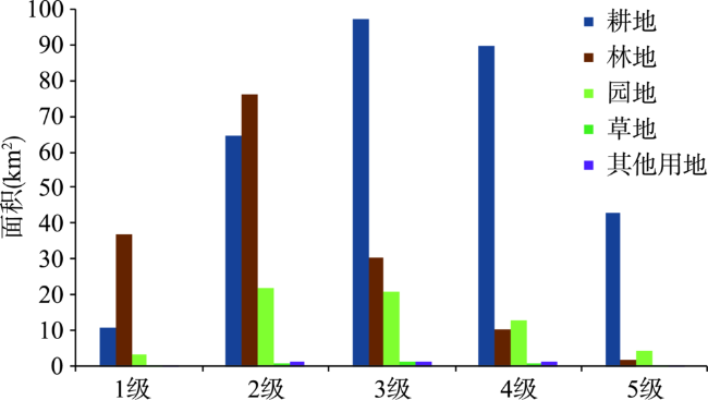
Tab. 5 Area and percentage of evaluation grade of ecological suitability for each land use type表5 各土地利用类型生态适宜度评价等级的面积及百分比 |
| 类型 | 总面积 | 1级 | 2级 | 3级 | 4级 | 5级 | |||||||||
|---|---|---|---|---|---|---|---|---|---|---|---|---|---|---|---|
| 面积(km2) | 比例 (%) | 面积 (km2) | 比例 (%) | 面积 (km2) | 比例 (%) | 面积 (km2) | 比例 (%) | 面积 (km2) | 比例 (%) | ||||||
| 耕地 | 305.20 | 10.92 | 3.58 | 64.37 | 21.09 | 97.15 | 31.83 | 89.86 | 29.44 | 42.90 | 14.06 | ||||
| 林地 | 154.72 | 36.68 | 23.71 | 76.04 | 49.15 | 30.42 | 19.66 | 10.05 | 6.50 | 1.51 | 0.98 | ||||
| 园地 | 63.52 | 3.47 | 5.46 | 21.94 | 34.54 | 21.08 | 33.19 | 12.76 | 20.08 | 4.28 | 6.73 | ||||
| 草地 | 3.42 | 0.11 | 3.15 | 0.89 | 26.18 | 1.47 | 42.92 | 0.64 | 18.69 | 0.31 | 9.06 | ||||
| 其他用地 | 4.80 | 0.30 | 6.18 | 1.31 | 27.33 | 1.42 | 29.52 | 1.27 | 26.53 | 0.50 | 10.44 | ||||
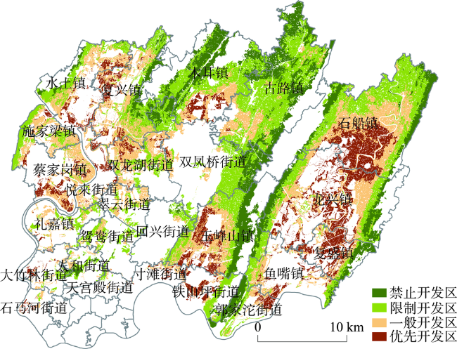
Fig. 8 Construction distribution of gentle hillside land图8 低丘缓坡地建设分区 |
Tab. 6 Area and spatial distribution features of all construction areas for gentle hillside land表6 低丘缓坡土地各建设区的面积与空间分布特征 |
| 土地建设分区 | 面积(km2) | 比例(%) | 分布区域 |
|---|---|---|---|
| 禁止开发区 | 92.22 | 17.35 | “四山”地区 |
| 限制开发区 | 201.74 | 37.95 | 中部400~450 m台地地区 |
| 一般开发区 | 157.26 | 29.58 | 西部河流两岸250~350 m地带、铜锣山两侧槽谷地区 |
| 优先开发区 | 80.43 | 15.12 | 西部河流两岸附近1000 m、东部槽谷地区 |
Tab. 7 Comparison of construction subareas with regulatory zoning表7 建设分区与管制分区比较 |
| 分区类型 | ||||
|---|---|---|---|---|
| 禁止开发区 | 限制开发区 | 一般开发区 | 优先开发区 | |
| 面积相似度(%) | 99.33 | 81.34 | 66.78 | 70.12 |
| 空间分布相似度(%) | 86.34 | 77.35 | 74.04 | 73.36 |
The authors have declared that no competing interests exist.
| [1] |
[
|
| [2] |
[
|
| [3] |
[
|
| [4] |
[
|
| [5] |
[
|
| [6] |
[
|
| [7] |
[
|
| [8] |
[
|
| [9] |
焦胜李振民,
[
|
| [10] |
[
|
| [11] |
[
|
| [12] |
[
|
| [13] |
|
| [14] |
[
|
| [15] |
[
|
| [16] |
[
|
| [17] |
[
|
| [18] |
|
| [19] |
[
|
| [20] |
[
|
| [21] |
[
|
| [22] |
[
|
| [23] |
[
|
| [24] |
[
|
/
| 〈 |
|
〉 |