
国土空间规划中水源涵养功能生态保护红线备选区的识别
|
李萌(1990- ),女,辽宁法库人,硕士,研究方向为区域发展与区域规划。E-mail: lim.14s@igsnrr.ac.cn |
收稿日期: 2018-01-02
要求修回日期: 2019-09-03
网络出版日期: 2019-10-30
基金资助
国家自然科学基金项目(41171109)
中国科学院STS项目(KFJ-EWSTS-089)
版权
Identification of the candidate areas of ecological protection red lines based on water conservation function in territory spatial planning
Received date: 2018-01-02
Request revised date: 2019-09-03
Online published: 2019-10-30
Copyright
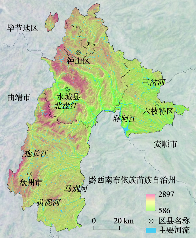
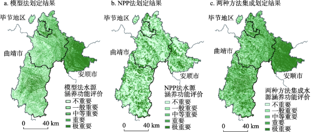
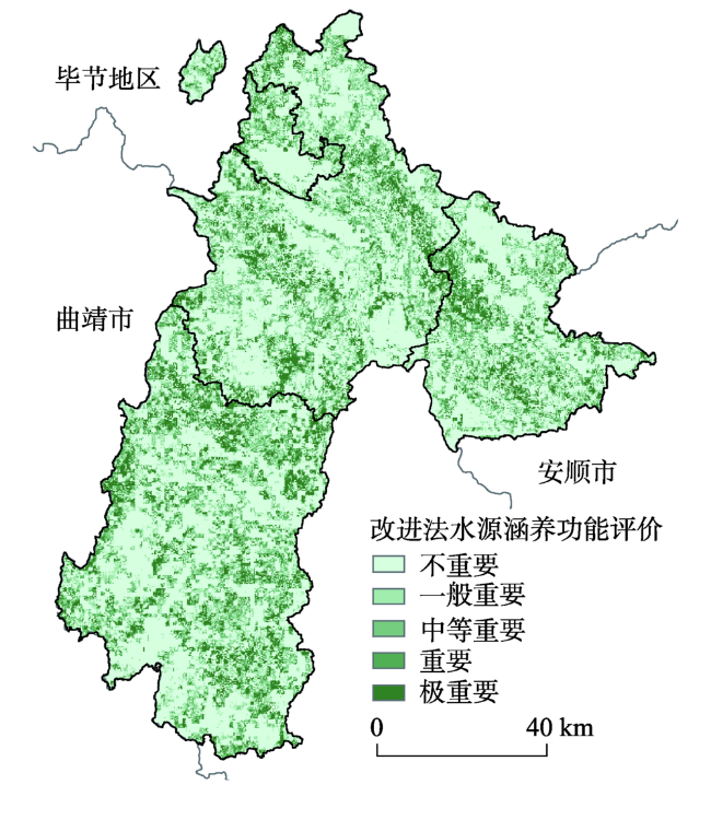
水源涵养功能重要性是生态保护红线划分工作中重要的评价指标之一。通过对以往生态系统水源涵养功能区划分的指标及其区域导向的系统梳理,在进一步明晰国土空间规划中水源涵养功能生态保护红线区域指向的基础上,按照国土空间规划关于“三区三线”自下而上试划的要求,探讨了水源涵养重要性生态保护红线划分及其评价的改进方法。选取中国典型喀斯特区域六盘水市作为研究案例区,分别用环保部2015版与2017版《生态保护红线划定技术指南》中的模型法、NPP法以及本研究提出的改进方法,对六盘水市水源涵养功能生态保护红线进行了试划。对比三种方法的划定结果可以看出,改进方法因评价数据精度的提高减少了《生态保护红线划定技术指南》方法的区域损失,提高了区域判别的精准性,可望为国土空间规划中生态保护红线的划定提供科学依据。
李萌 , 王传胜 , 张雪飞 . 国土空间规划中水源涵养功能生态保护红线备选区的识别[J]. 地理研究, 2019 , 38(10) : 2447 -2457 . DOI: 10.11821/dlyj020180011
The importance of the water conservation functional region is one of the key classification indexes to define the ecological protection “red line”, i.e. the ecological protection area with the highest priority. After reviewing the classification indexes previously used for identifying the water conservation functional region and investigating their potential influences on applied areas, we propose a new method of the Red Line determination, taking the water conservation ability into account and discuss an improvement in the evaluation of the red line determination method, fulfilling the requirement of the national spatial planning, i.e. the “Three Zones and Three Lines” bottom-up determination (Three Zones represent ecological space, agricultural space, and urban space; Three Lines represent ecological conservation redline, permanent capital farmland, and urban development boundary). The study area in this paper is Liupanshui, Guizhou, a typical karst landform region in China. After combing through the previously used indexes as well as the target areas for classifying the water conservation function, we compare results of the Red Line determined by three methods, which are the modeling method, the quantifying index method (NPP) (both methods were proposed in the “Guidelines for the Delimitation of the Ecological Protection Red Line” and published by the MEP of China respectively in 2015 and 2017) and an improved method we newly propose in this study. Our method introduces two factors. One is the “vegetation cover index”, used in recognizing non-ecological land and in increasing the weight of the positive effects of the water conservation function on the forest land. The other is the “elevation index”, for including qualified mountain top areas as alternatives of the red line. In Liupanshui, 34.25% of the cultivated land areas is selected as the candidates for the red line, using our newly proposed method. The percentage of the cultivated land is less than the ones obtained by the modeling method (46.62%) and NPP (38.54%). Further, our method identifies more candidates of forest land areas by the amount of 44.2%, while the modeling method reaches 25.31% only and NPP reaches 43.74%. In conclusion, using the vegetation cover index and the elevation index to classify the water conservation functional regions, the red line determined by our method has a better match with the real ecological condition of Liupanshui, compared to the results from the modeling method and NPP. Therefore, we advocate these two indexes to be included as additional indicators in the “Guidelines for the Delimitation of the Ecological Protection Red Line”, in order to increase the precision of the redline determination.
表1 政府主导实施的部分规划或区划中关于水源涵养功能区划分方法Tab. 1 Methods of dividing function area of water conservation planning or zoning carried out by the government |
| 来源 | 划定方法 | 原理说明 | |||||
|---|---|---|---|---|---|---|---|
| 全国主体功能区划[2] | 流域级别 | 生态系统类型 | 重要性 | 识别流域单元,根据各级别单元的生态系统类型的构成判别水源涵养功能的重要性。 | |||
| 一级流域 | 森林、湿地/草原草垫/荒漠 | 高/较高/中等 | |||||
| 二级流域 | 森林、湿地/草原草垫/荒漠 | 较高/中等/较低 | |||||
| 三级流域 | 森林、湿地/草原草垫/荒漠 | 中等/较低/低 | |||||
| 全国生态功能区划[3] | ①从土壤侵蚀敏感性角度评价河流、水源水体重要性 | 根据土壤侵蚀敏感性评价结果,识别不同水体水源涵养功能重要性。并加入重要的水源供给地及洪水调蓄区。 | |||||
| 土壤侵蚀敏感性影响水体 | 不敏感 | 轻度敏感 | 中度敏感 | 高度敏感 | 极敏感 | ||
| 一级、二级河流及大众城市主要水源水体 | 不重要 | 中等重要 | 极重要 | 极重要 | 极重要 | ||
| 三级河流及小城镇水源水体 | 不重要 | 不重要 | 中等重要 | 中等重要 | 极重要 | ||
| 四级、五级河流 | 不重要 | 不重要 | 较重要 | 中等重要 | 中等重要 | ||
| ② 对于水源涵养和洪水调蓄重要性评价方法 | |||||||
| 类型 | 干旱 | 半干旱 | 半湿润 | 湿润 | |||
| 城市水源地 | 极重要 | 极重要 | 极重要 | 极重要 | |||
| 农灌取水区 | 极重要 | 极重要 | 中等重要 | 不重要 | |||
| 洪水调蓄 | 不重要 | 不重要 | 中等重要 | 极重要 | |||
| 汶川/玉树/庐山 资源环境承载 能力评价[4,5,6] | 流域级别 | 生态系统类型 | 重要性 | 综合考虑流域级别和城乡供水因素,确定水源涵养功能重要性级别。 | |||
| 二级以上流域河流源头,县级城市水源地 | 森林,湿地,草原,草垫 | 极重要 | |||||
| 三级流域河流源头,其他水源地 | 森林,湿地,草原,草垫 | 重要 | |||||
| 其他区域 | 森林,湿地,草原,草垫及其他 | 不重要 | |||||
| 林业部《推进生 态文明建设规划 纲要》[7] | 林地和森林红线区域:流程500 km以上的江河发源地汇水处,主流与一级、二级支流两岸山地第一层山脊以内;流程500 km以下的河流,其河流发源地汇水区及主流、一级支流两岸山地第一层山脊以内;大中型水库与湖泊周围山地第一层山脊以内或平地1000 m以内,小型水库与湖泊周围第一层山脊以内或平地250 m以内;保护城镇饮用水源的森林、林木、林地。 | 根据河流级别,确定水源涵养区的识别标准,根据水源地功能,确定保护范围和等级。 | |||||
| 水利部《关于推进水生态文明建设工作的意见》[8] | 在重要江河湖泊水功能区内划定水生态“三条红线”,其选取原则为:① 国家重要江河干流及其主要支流;② 涉水的国家级及省级自然保护区、国际重要湿地、国家级水产种质资源保护区、跨流域调水水源地及重要饮用水水源地;③ 国家重点湖库水域;④ 主要省际边界水域、重要河口水域。 | 在河流发源地、水域河口、湿地等水源涵养功能重要区域内划定水功能“三条红线”。 | |||||
| 国家海洋局《关 于建立渤海海洋 生态红线制度若 干意见》[9] | 重要海洋生态红线区,包括:重要河口、重要滨海湿地、海岛、海洋保护区、自然景观及历史文化遗迹。 | 把具有水源涵养功能的沿海湿地纳入重点保护区域。 | |||||
| 全国资源环境承 载能力及其预警 评估[10] | 在重要水源涵养功能区内计算单位面积的水源涵养量,作为单位面积功能重要性评判的依据。 | ||||||
| 式中:TQ为总水源涵养量;Pi降雨量;Ri为地表径流量;ETi为蒸散发量;Ai为i类生态系统的面积;i为研究区第i类生态系统类型;j为研究区生态系统类型数。 | |||||||
表2 模型法、NPP法评价方法及分级标准介绍Tab. 2 Introduction to the model method, NPP method evaluation method and classification standard |
| 方法名称 | 评价方法 | 评价分级标准 |
|---|---|---|
| 模型评价法 | 将计算所得的水源涵养功能服务值采用自然分界法进行四级分类操作,并按服务值大小由低到高依次划分为一般重要、中等重要、重要、极重要。 | |
| 式中:WY为水源涵养量;P为多年平均年降雨量;ET为蒸散量;PET为多年平均潜在蒸发量;ω为下垫面影响系数。根据土地利用类型赋值,耕地为0.5,高覆盖林地(覆盖度>30%)为2,低覆盖林地(覆盖度<30%)为1,灌丛为1,草地为0.5,人工用地为0.1,其他为0.1。 | ||
| NPP定量指标评价法 | 将每一个栅格像元的生态系统服务值从高到低的顺序排列,计算累加服务值。将累加服务值占生态系统服务总值比例的50%与80%所对应的栅格值,作为生态系统服务功能评估分级的分界点。将生态系统服务功能重要性分为三级,即极重要、重要和一般重要。 | |
| 式中:WR为生态系统水源涵养服务能力指数;NPPmean为区域多年生态系统净初级生产力平均值;Fsic、Fpre、Fslp分别为标准化后的土壤渗流因子、多年平均降雨量和坡度因子。 |
表3 地表覆盖因子系数赋值Tab. 3 Value assignment of surface covering factor |
| 赋值 | 0.9 | 0.7 | 0.5 | 0.3 | 0.1 |
|---|---|---|---|---|---|
| 地理国情普查代码(2015) | 310/340/1000 | 320/330/350/380/411 | 360/370/412/413/420 | 100/200/900 | 500~800 |
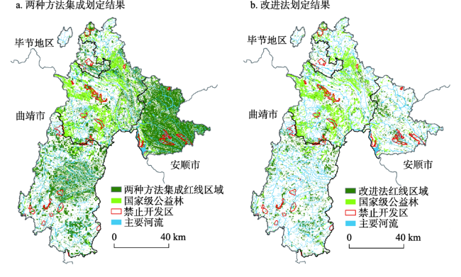
图4 《指南》中两种评价方法集成和改进法的划定结果与禁止开发区、国家级公益林分布状况Fig. 4 The results of the integration of the two methods in "Guidelines for the Delineation of the Red-line for Ecological Protection", as well as the improved method and forbidden development zone, and public welfare forest |
表4 《指南》方法与改进方法划定的生态保护红线中各类土地利用类型的比例(%)Tab. 4 Proportion of each land use type in the ecological protection red-line defined by the methods in "Guidelines for the Delineation of the Red-line for Ecological Protection" and improved method (%) |
| 土地利用类型 | 划定方法 | |||
|---|---|---|---|---|
| 模型法 | NPP法 | 方法集成 | 改进法 | |
| 耕地 | 46.62 | 38.54 | 43.21 | 34.25 |
| 园地 | 0.51 | 0.49 | 0.52 | 0.43 |
| 林地 | 25.31 | 43.74 | 32.71 | 44.20 |
| 草地 | 9.03 | 8.73 | 8.87 | 13.08 |
| 交通运输用地 | 0.94 | 0.35 | 0.72 | 0.36 |
| 水域及水利设施用地 | 1.61 | 0.44 | 1.16 | 0.41 |
| 其他用地 | 7.27 | 3.86 | 6.02 | 5.22 |
| 城镇村及工矿用地 | 8.71 | 3.84 | 6.79 | 2.05 |
| 禁止开发区 | 3.09 | 5.09 | 3.82 | 4.16 |
| 公益林 | 1.75 | 5.52 | 3.57 | 7.01 |
| 农业、城镇用地 | 56.63 | 43.17 | 51.12 | 37.03 |
注:“禁止开发区”范围为牂柯江湿地公园、明湖湿地公园、娘娘山湿地公园、凉都森林公园、七指峰森林公园、玉舍森林公园、杨梅森林公园、六枝月亮河森林公园、野钟自然保护区、乌蒙山国家地质公园及集中式饮用水水源地一级保护区。“公益林”范围为国家级公益林一级。 |
| [1] |
李干杰 . “生态保护红线”: 确保国家生态安全的生命线. 求是, 2014, ( 2):44-46.
[
|
| [2] |
国务院. 全国主体功能区规划(2010). , 2011-06-08.
[ The State Council of the People's Republic of China. National main function area planning(2010). , 2011-06-08.]
|
| [3] |
环境保护部, 中国科学院. 全国生态功能区划(修编版). , 2015-11-23.
[ Ministry of Environmental Protection,Chinese Academy of Sciences. National Ecological Function Zoning (revised edition). , 2015-11-23.]
|
| [4] |
樊杰 . 国家汶川地震灾后重建规划: 资源环境承载能力评价. 北京: 科学出版社, 2009.
[
|
| [5] |
樊杰 . 玉树地震灾后恢复重建-资源环境承载能力评价. 北京: 科学出版社, 2010.
[
|
| [6] |
樊杰 . 芦山地震灾后恢复重建资源环境承载能力评价. 北京: 科学出版社, 2014.
[
|
| [7] |
国家发展与改革委员会. 资源环境承载能力检测预警技术方法, 2016.
[ The Development and Reform Commission. Technology and Method of Detecting and Early-warning of Carrying Capacity of Resources and Environment, 2016.]
|
| [8] |
国家林业局. 推进生态文明建设规划纲要(2013-2020年), 2013.
[ Ministry of Forestry. Outline for promoting the Construction of Ecological Civilization (2013-2020), 2013.]
|
| [9] |
中华人民共和国水利部. 关于加快推进水生态文明建设工作的意见, 2013.
[ Ministry of Water Resources. Suggestions on Speeding Up The Construction of Water Ecological Civilization, 2013.]
|
| [10] |
国家海洋局. 关于建立渤海海洋生态红线制度若干意见, 2012.
[ National Bureau of Oceanography. Establishment of the Marine Ecological Red Line System in the Bohai Sea, 2012]
|
| [11] |
|
| [12] |
欧阳志云, 王效科, 苗鸿 . 中国陆地生态系统服务功能及其生态经济价值的初步研究. 生态学报, 1999,19(5):19-25.
[
|
| [13] |
陈仲新, 张新时 . 中国生态系统效益的价值. 科学通报, 2000,45(1):17-22, 113.
[
|
| [14] |
谢高地, 鲁春霞, 肖玉 , 等. 青藏高原高寒草地生态系统服务价值评估. 山地学报, 2003,21(1):50-55.
[
|
| [15] |
吴钢, 肖寒, 赵景柱 , 等. 长白山森林生态系统服务功能. 中国科学: 生命科学, 2001,31(5):471-480.
[
|
| [16] |
崔丽娟 . 鄱阳湖湿地生态系统服务功能价值评估研究. 生态学杂志, 2004,23(4):47-51.
[
|
| [17] |
欧阳志云, 赵同谦, 赵景柱 , 等. 海南岛生态系统生态调节功能及其生态经济价值研究. 应用生态学报, 2004,15(8):1395-1402.
[
|
| [18] |
马琪, 刘康, 刘文宗 , 等. 干旱半干旱区生态保护红线划分研究: 以“多规合一”试点榆林市为例. 地理研究, 2018,37(1):158-170.
[
|
| [19] |
包玉斌, 李婷, 柳辉 , 等. 基于InVEST模型的陕北黄土高原水源涵养功能时空变化. 地理研究, 2016,35(4):664-676.
[
|
| [20] |
刘学全, 唐万鹏, 崔鸿侠 . 丹江口库区主要植被类型水源涵养功能综合评价. 南京林业大学学报: 自然科学版, 2009,33(1):59-63.
[
|
/
| 〈 |
|
〉 |