
国土空间规划:基础设施与公共服务设施单幅总图的研制
|
王姣娥(1981- ),女,湖南涟源人,研究员,主要从事交通地理与区域发展、大数据与城市交通研究。E-mail: wangje@igsnrr.ac.cn |
收稿日期: 2017-11-23
要求修回日期: 2018-09-26
网络出版日期: 2019-10-30
基金资助
国家自然科学基金项目(41722103)
版权
Research on a comprehensive map of infrastructure and public facilities for territory spatial planning
Received date: 2017-11-23
Request revised date: 2018-09-26
Online published: 2019-10-30
Copyright
王姣娥 , 陈卓 , 景悦 , 黄洁 , 金凤君 . 国土空间规划:基础设施与公共服务设施单幅总图的研制[J]. 地理研究, 2019 , 38(10) : 2496 -2505 . DOI: 10.11821/dlyj020171110
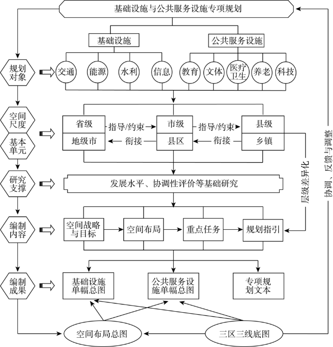
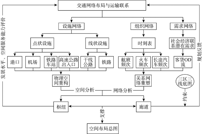
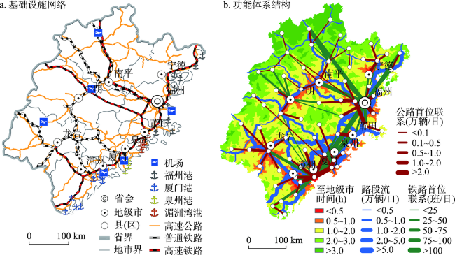
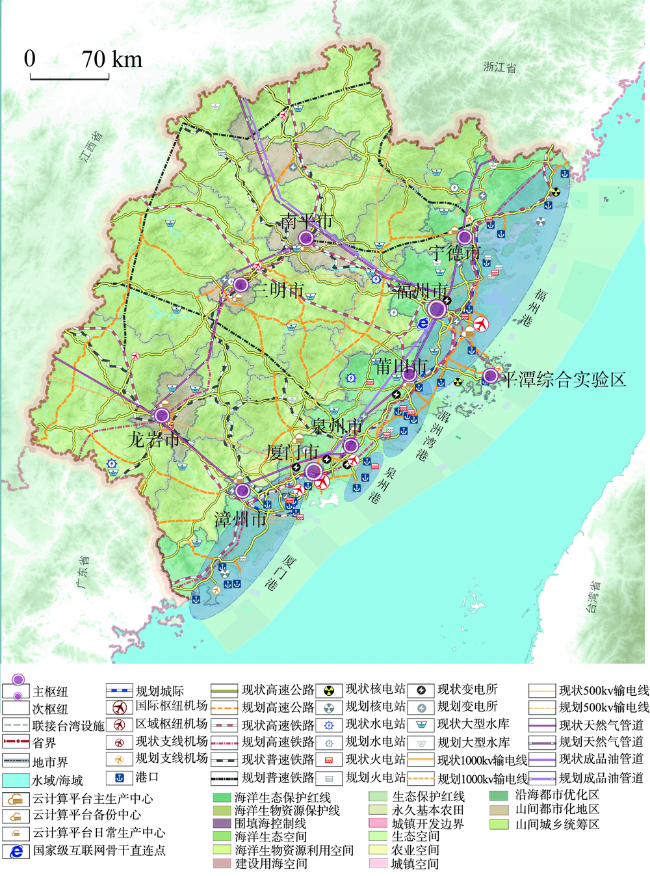
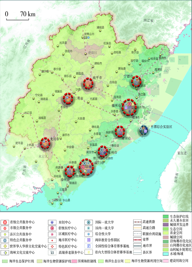
Infrastructure is a human-built system based on the physical environment, thus the layout of infrastructure network represents the relationship of human-related spatial interactions between places. Infrastructure system is not only an important component for shaping regional spatial structure, but also a key element for regional development. Since infrastructure is significant for leading and optimizing the spatial order of regional development, thus it is also necessary for spatial planning. The paper analyzes existing planning systems for infrastructure construction, and then provides a theoretical framework for planning infrastructures and public service facilities in spatial planning. The existing planning systems mainly have the following problems. Firstly, the content of public service facilities planning has not been valued. Secondly, the departmental segmentation of the transportation management system leads to a prominent interest of departments in the special plan. Last but not least, the relationships between planning levels are unreasonable, and a single general map covering all types of infrastructures is lacking. Therefore, from the perspective of overall spatial layout, the paper proposes a theoretical framework for the integrated planning of infrastructure and public service facilities based on the general patterns of social and economic development. The theoretical framework includes the content that should be covered by the planning scheme, the technical roadmap for working out the project, as well as key planning points on different spatial scales at the provincial, municipal, and county levels. What's more, combined with the network layout of transportation facilities and the spatial pattern of traffic activities, a technical framework of hub and corridor identification is designed. Finally, with the case study of Fujian, the paper explores the research flowchart for infrastructure and public service facilities, emphasizes the relationship between special planning, Three Zones and Three Lines (Three Zones represent ecological space, agricultural space, and urban space; Three Lines represent ecological conservation redline, permanent capital farmland, and urban development boundary) and spatial overall layout, aiming to provide experiences for spatial planning in other parts of China. In Fujian's spatial planning, we first design the special comprehensive map of public facilities and standardize some new legends. The comprehensive map of infrastructure system contains all elements such as energy facilities, water resource facilities, and information and communication facilities in addition to transport infrastructure.
Key words: territory spatial planning; infrastructure; public service; corridor; hub
表1 中国基础设施与公共服务设施专项规划体系的基本情况Tab. 1 The basics of infrastructure and public services planning in China |
| 系列 | 类别 | 层级 | 主要内容 | 主管部门 |
|---|---|---|---|---|
| 基础设施规划 | 综合交通发展规划 | 全国、省级、市级 | 全国和省级层面包括铁路、公路、机场、水运和管道规划;地市尺度则主要包括公路和水运规划 | 交通部 |
| 公路网规划 | 全国、省级、市级、县级 | 包括各行政区和特定区域的公路网规划,内容主要为公路网现状与需求、公路发展目标与布局、公路网建设分期安排、规划实施的政策与措施等 | 交通部 | |
| 航道发展规划 | 全国、流域(跨省域)、省级 | 分为国家、地方(省级、跨省域)、专用航道发展规划,包括规划目标、技术等级、布局方案、主要建设工程、实施措施等内容 | 港务局 | |
| 港口规划 | 全国、省级、市级、县级 | 包括港口布局规划和港口总体规划,前者是指港口的分布规划(包括国家级和省级),后者是指一个港口在一定时期的具体规划,两者均可编制专项规划,有关部门应根据后者编制港口控制性详细规划 | 港务局 | |
| 铁路网规划 | 全国、省级、市级、县级 | 包括国家铁路、地方铁路、专用铁路和铁路枢纽、铁路设施等的布局、建设安排 | 原铁道部 | |
| 电力发展规划 | 国家级、省级、市级、县级 | 电网、电力设施等的规划建设 | 能源局 | |
| 管道规划 | 全国、企业 | 国务院能源主管部门编制全国管道发展规划,管道企业应当根据全国管道发展规划编制管道建设规划 | 能源局 | |
| 水利设施规划 | 全国、省级、市级、县级 | 包括江河流域、区域性防洪、除涝、灌溉等水利水电工程,河道整治、水资源保护、开发和灌区综合利用等工程的布局、建设安排等 | 水利部 | |
| 信息化规划 | 全国、省级、市级 | 包括宽带网络、光缆、管道、基站等通信基础设施、公共平台体系、云计算基础设施、电信网、广播电视网和互联网网络基础设施、数据中心建设等 | 工信部 | |
| 公共服务设施规划 | 教育规划 | 全国、省级、市级 | 包括学前教育、义务教育、高中教育、职业教育、高等教育等 | 教育部 |
| 养老院规划 | 全国、省级、市级、县级 | 包括社会保障、机构养老、社区养老、养老设施等 | 民政部 | |
| 医疗卫生规划 | 全国、省级、市级、县级 | 包括医疗中心、医疗机构、床位、疾控中心等 | 卫计委 | |
| 体育设施规划 | 全国、省级、市级、县级 | 包括公共体育设施、体育场馆、体育基地、体育赛事、群众健身中心等 | 体育局 | |
| 文化设施规划 | 全国、省级、市级、县级 | 包括图书馆、文化馆、博物馆等公共文化设施和文物保护工程、文化品牌建设工程等 | 文化局 |
注:指标根据王向东等[8]修改更新。 |
| [1] |
金凤君 . 基础设施与经济社会空间组织 北京: 科学出版社, 2012.
[
|
| [2] |
樊杰 . 我国主体功能区划的科学基础. 地理学报, 2007,62(4):339-350.
[
|
| [3] |
樊杰, 洪辉 . 现今中国区域发展值得关注的问题及其经济地理阐释. 经济地理, 2012,32(1):1-6.
[
|
| [4] |
樊杰 . 我国空间治理体系现代化在“十九大”后的新态势. 中国科学院院刊, 2017. 32(4):396-404.
[
|
| [5] |
刘彦随, 王介勇 . 转型发展期“多规合一”理论认知与技术方法. 地理科学进展, 2016,35(5):529-536.
[
|
| [6] |
刘卫东, 陆大道 . 新时期我国区域空间规划的方法论探讨: 以“西部开发重点区域规划前期研究”为例. 地理学报, 2005,60(6):16-24.
[
|
| [7] |
杨保军, 张菁, 董珂 . 空间规划体系下城市总体规划作用的再认识. 城市规划, 2016, ( 3):9-14.
[
|
| [8] |
王向东, 刘卫东 . 中国空间规划体系: 现状、问题与重构. 经济地理, 2012,32(5):7-15, 29.
[
|
| [9] |
樊杰, 蒋子龙, 陈东 . 空间布局协同规划的科学基础与实践策略. 城市规划, 2014,38(1):16-25, 40.
[
|
/
| 〈 |
|
〉 |