
快速城市化地区土地利用规划管控建设用地扩张成效评估——以南京市为例
|
乔伟峰(1975-),男,江苏徐州人,博士,副教授,硕士生导师,主要研究方向为土地资源管理和城乡转型发展研究。E-mail: qiaoweifeng@njnu.edu.cn |
收稿日期: 2018-07-10
要求修回日期: 2019-05-14
网络出版日期: 2019-12-02
基金资助
国家自然科学基金项目(41871178)
国家自然科学基金项目(41671385)
国家自然科学基金项目(41901204)
教育部人文社会科学青年基金(19YJCZH036)
版权
Evaluating the controlling effectiveness of land-use planning on construction land expansion under the rapid urbanization: A case study of Nanjing city
Received date: 2018-07-10
Request revised date: 2019-05-14
Online published: 2019-12-02
Copyright
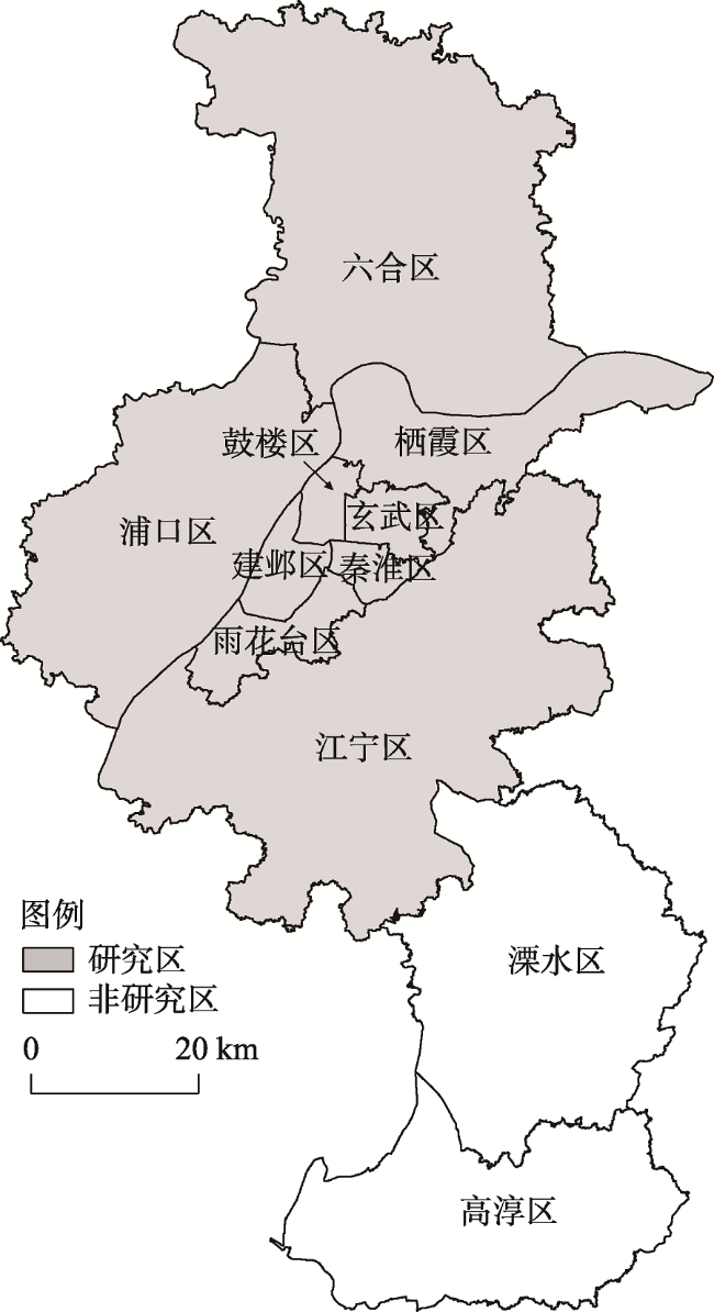
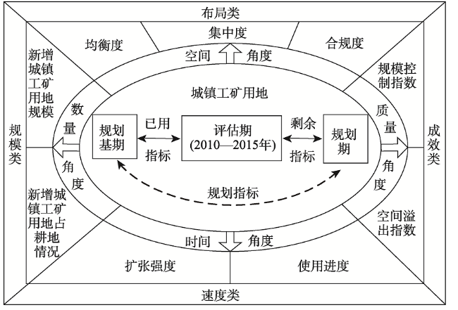
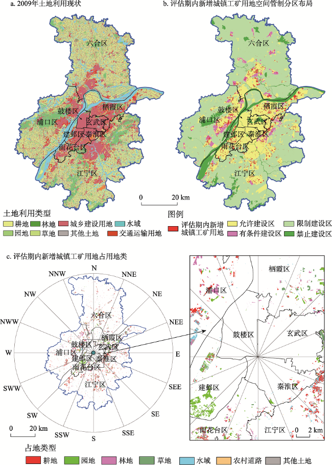
科学评估土地利用总体规划管控建设用地扩张的成效对于规划编制方法和规划管理措施的改进意义重大。本文基于土地利用总体规划的相关指标,从时间、空间、数量和质量等视角构建城镇扩张评估指标体系,选择快速城市化地区南京市为例进行研究。主要结论为:① 南京市土地利用总体规划对建设用地扩张强度的管控有一定成效但仍需加强。规划期除2013年以外,其余年份新增城镇工矿用地规模均高于规划年均控制规模,至2015年指标使用进度高达78.83%,规划剩余年限用地需求难以满足;② 南京城市空间扩张态势与规划城镇用地空间扩张格局基本吻合。不同方向指标使用进度存在较大的差异性,呈东北和西北部快、南部慢的格局;集中度和合规度指标较好;③ 评估期内规模控制指数为-0.97,空间溢出指数为0.34,规划对新增城镇工矿用地管控力度偏弱,规划的累积执行效果呈逐年变差的趋势。④ 本文构建的指标体系可全方位、多角度评估城镇扩张的规划管控成效,对其他地区的规划实施评估有一定的借鉴意义。
乔伟峰 , 吴菊 , 戈大专 , 王亚华 , 曹敏 . 快速城市化地区土地利用规划管控建设用地扩张成效评估——以南京市为例[J]. 地理研究, 2019 , 38(11) : 2666 -2680 . DOI: 10.11821/dlyj020180713
Scientific evaluation of land use general planning on controlling the effectiveness of construction land expansion is of great significance for the improvement of planning methods and management measures. Based on the relevant indicators of the land-use general planning, this paper constructs the urban expansion evaluation index system from the perspectives of time, space, quantity and quality, and selects the rapidly urbanized area of Nanjing City as an example. The results indicate that: 1) Land-use general planning of Nanjing has some effect on the control of the expansion of construction land, but it still needs to be strengthened. In addition to 2013, the scale of newly added urban industrial and mining land in the rest of the planning period is higher than that of the planned annual average control. By 2015, the using process of construction land planning indicators reached 78.83%, and it is difficult to meet the land demand for planning the remaining years; 2) The expansion of urban construction land in Nanjing is basically consistent with the planned spatial expansion pattern of urban land use. There are large differences in the using process of land indicators in different directions, which are fast in the northeast and northwest but slow in the south. Moreover, the concentration and compliance indicators are better; 3) The control index of land use scale during the evaluation period is -0.97, and the spatial spillover index is 0.34. The land use planning is weak under the control of new urban industrial and mining land expansion. Simultaneously, the cumulative implementation effectiveness of land-use general planning shows a deteriorating trend year by year. The comprehensive evaluation index has been 4.39 since 2010, and the cumulative execution effect of the plan shows a worsening tendency. The scientificness of the planning compilation and the binding of planning implementation need to be strengthened. 4) The index system constructed in this paper can evaluate the effectiveness of planning and control of urban expansion in all-round directions and multi-angles, and has certain reference for the evaluation of planning implementation in other regions.
表1 土地利用总体规划实施成效评价指标体系Tab. 1 Evaluation index system of land-use general planning implementation effectiveness |
| 指标类型 | 指标名称 | 指标说明或指标算法 |
|---|---|---|
| 规模类 | 新增城镇工矿用地规模 | 评估年其他地类转为城镇工矿用地的面积 |
| 新增城镇工矿用地占耕地情况 | 评估年耕地转为城镇工矿用地的面积和比例 | |
| 速度类 | 扩张强度 | 评估年新增城镇工矿用地面积 / 上一年城镇工矿用地总面积 |
| 指标使用进度 | 至评估年累计新增城镇工矿用地面积 / 规划期新增城镇工矿用地指标 | |
| 布局类 | 均衡度 | 评估年新增城镇工矿用地指标在不同方向上的使用进度 |
| 集中度 | 评估年围绕上一年城镇工矿用地边界扩张的面积 / 评估年全部新增城镇工矿用地面积 | |
| 合规度 | 新增城镇工矿用地布局在不同空间管制分区的规模和比例 | |
| 成效类 | 规模控制指数[16] | 1–(评估期实际新增城镇工矿用地面积 / 评估期规划新增城镇工矿用地面积) |
| 空间溢出指数[16] | 评估期扩展边界外新增城镇工矿用地面积/评估期规划新增城镇工矿面积 |
表2 评估期内历年新增城镇工矿用地在空间管制分区布局情况Tab. 2 The newly added urban industrial and mining land in space control zoning layout in 2010-2015 |
| 允许建设区新增 | 有条件建设区新增 | 限制建设区新增 | 禁止建设区新增 | 合计 | |||||
|---|---|---|---|---|---|---|---|---|---|
| 面积 (km²) | 占比 (%) | 面积 (km²) | 占比 (%) | 面积 (km²) | 占比 (%) | 面积 (km²) | 占比 (%) | ||
| 2010年 | 31.19 | 71.02 | 4.84 | 11.02 | 7.85 | 17.87 | 0.04 | 0.09 | 43.91 |
| 2011年 | 17.23 | 81.20 | 1.12 | 5.28 | 2.80 | 13.20 | 0.07 | 0.33 | 21.23 |
| 2012年 | 12.54 | 67.31 | 2.98 | 16.00 | 2.95 | 15.83 | 0.16 | 0.86 | 18.63 |
| 2013年 | 5.59 | 67.27 | 0.76 | 9.15 | 1.91 | 22.98 | 0.05 | 0.60 | 8.32 |
| 2014年 | 7.92 | 74.30 | 1.25 | 11.73 | 1.45 | 13.60 | 0.04 | 0.38 | 10.66 |
| 2015年 | 7.24 | 69.62 | 0.97 | 9.33 | 2.13 | 20.48 | 0.06 | 0.00 | 10.39 |
| 评估期(2010—2015年) | 81.71 | 72.22 | 11.92 | 10.54 | 19.09 | 16.87 | 0.42 | 0.37 | 113.14 |
表3 新增城镇工矿用地占地情况分析Tab. 3 Analysis of the occupation of other types of land by newly added urban industrial and mining land (km2) |
| 耕地 | 园地 | 林地 | 草地 | 农村道路 | 水域及水利设施用地 | 其他土地 | |
|---|---|---|---|---|---|---|---|
| 2010年 | 13.52 | 15.55 | 5.86 | 2.91 | 0.32 | 3.88 | 0.82 |
| 2011年 | 8.93 | 4.00 | 1.98 | 0.49 | 0.24 | 3.05 | 0.81 |
| 2012年 | 8.71 | 1.86 | 3.04 | 0.88 | 0.33 | 3.11 | 0.65 |
| 2013年 | 3.86 | 1.70 | 0.95 | 0.33 | 0.15 | 1.04 | 0.26 |
| 2014年 | 5.33 | 1.26 | 1.06 | 0.33 | 0.24 | 1.96 | 0.47 |
| 2015年 | 5.82 | 0.88 | 0.84 | 0.24 | 0.22 | 1.91 | 0.24 |
| 评估期(2010—2015年) | 46.17 | 25.24 | 13.74 | 5.17 | 1.51 | 14.94 | 3.26 |
表4 2010—2015年评估期内历年城镇工矿用地扩张情况Tab. 4 Expansion rate of urban industrial and mining land in 2010-2015 (%) |
| 指标 | 2010年 | 2011年 | 2012年 | 2013年 | 2014年 | 2015年 | 评估期(2010—2015年) |
|---|---|---|---|---|---|---|---|
| 扩张强度 | 6.58 | 2.99 | 2.55 | 1.11 | 1.40 | 1.35 | 16.97 |
| 使用进度 | 30.60 | 45.39 | 58.37 | 64.17 | 71.59 | 78.83 | 78.83 |
| 集中度 | 83.92 | 89.38 | 74.88 | 73.20 | 83.77 | 76.25 | 73.17 |
表5 评估期土地利用总体规划的管控效果分析Tab. 5 Analysis results of land-use general planning controlling effectiveness |
| 评估期规划 新增(km²) | 评估期实际 新增(km²) | 评估期扩展边界内 新增(km²) | 规模控制 指数 | 空间溢出 指数 | |
|---|---|---|---|---|---|
| 城镇工矿用地 | 57.40 | 113.14 | 93.63 | -0.97 | 0.34 |
| 城乡建设用地 | 45.86 | 130.36 | 104.55 | -1.84 | 0.56 |
| [1] |
施利锋, 张增祥, 刘芳 , 等. 1973年—2013年经济特区城市空间扩展遥感监测. 遥感学报, 2015,19(6):1030-1039.
[
|
| [2] |
|
| [3] |
王亚华, 袁源, 王映力 , 等. 人口城市化与土地城市化耦合发展关系及其机制研究: 以江苏省为例. 地理研究, 2017,36(1):149-160.
[
|
| [4] |
方创琳, 李广东, 张蔷 . 中国城市建设用地的动态变化态势与调控. 自然资源学报, 2017,32(3):363-376.
[
|
| [5] |
钟太洋, 黄贤金, 王柏源 . 经济增长与建设用地扩张的脱钩分析. 自然资源学报, 2010,25(1):18-31.
[
|
| [6] |
|
| [7] |
吕晓, 黄贤金 . 建设用地扩张的研究进展及展望. 地理与地理信息科学, 2013,29(6):51-58.
[
|
| [8] |
|
| [9] |
|
| [10] |
|
| [11] |
|
| [12] |
|
| [13] |
冯科, 吴次芳, 韩昊英 , 等. 杭州市土地利用总体规划的建设用地控制成效研究: 界线评价法的引进与实践. 自然资源学报, 2010,25(3):376-385.
[
|
| [14] |
|
| [15] |
|
| [16] |
吕晓, 黄贤金, 钟太洋 , 等. 土地利用规划对建设用地扩张的管控效果分析: 基于一致性与有效性的复合视角. 自然资源学报, 2015,30(2):177-187.
[
|
| [17] |
邓羽 . 城市空间扩展的自组织特征与规划管控效应评估: 以北京市为例. 地理研究, 2016,35(2):353-362.
[
|
| [18] |
王婉晶, 揣小伟, 黄贤金 , 等. 中国土地利用规划实施评价研究进展与展望. 中国土地科学, 2012,26(11):91-96.
[
|
| [19] |
邓强, 陈建军, 田志强 . 基于一致性和绩效性分析的南宁市土地规划实施中期评估技术方法研究. 中国土地科学, 2014,28(9):39-46.
[
|
| [20] |
蒋仁开, 张冰松, 肖宇 , 等. 土地利用规划要引导和促进新型城镇化的健康发展: “新型城镇化背景下的土地利用规划研讨会”综述. 中国土地科学, 2013,27(8):93-96.
[
|
| [21] |
田志强, 王亚华, 尚津津 , 等. 基于土地利用规划实施的中心城区扩展监测评估研究: 以淮南市为例. 中国土地科学, 2015,29(11):56-62, 95.
[
|
| [22] |
王万茂, 王群 . 土地利用规划中不确定性的识别和处理研究.中国人口. 资源与环境, 2011,21(10):84-90.
[
|
| [23] |
杜金锋, 冯长春 . 当前中国土地利用总体规划实施评价中主要问题研究. 中国土地科学, 2008,22(10):74-80.
[
|
| [24] |
黄大全, 林坚, 梁进社 , 等. 北京市土地利用总体规划执行情况的评价方法. 地理科学进展, 2008,27(5):79-86.
[
|
| [25] |
李飞雪, 李满春, 刘永学 , 等. 建国以来南京城市扩展研究. 自然资源学报, 2007,22(4):524-535.
[
|
| [26] |
邓红蒂, 李宏, 王恒 , 等. 土地利用总体规划评估制度建设研究. 中国土地科学, 2012,26(7):4-9.
[
|
| [27] |
夏春云, 严金明 . 土地利用规划实施评价的指标体系构建. 中国土地科学, 2006,20(2):19-23.
[
|
| [28] |
王婉晶, 揣小伟, 黄贤金 , 等. 基于空间吻合性的土地利用总体规划实施评价方法及应用. 农业工程学报, 2013,29(4):1-14, 296.
[
|
| [29] |
张宇, 欧名豪, 靳晓雯 , 等. 土地利用总体规划实施评价方法研究. 中国土地科学, 2011,25(10), 40-46.
[
|
| [30] |
|
| [31] |
吴次芳, 邵霞珍 . 土地利用规划的非理性、不确定性和弹性理论研究. 浙江大学学报(人文社会科学版), 2005,35(4):425-433.
[
|
| [32] |
|
| [33] |
高金龙, 陈江龙, 徐梦月 , 等. 南京大都市区建设用地扩张特征与机理. 地理研究, 2014,33(3):427-438.
[
|
| [34] |
乔伟峰, 刘彦随, 王亚华 , 等. 2000年以来南京城市三维空间扩展特征. 地理研究, 2015,34(4):666-676.
[
|
| [35] |
陈百明, 张凤荣 . 我国土地利用研究的发展态势与重点领域. 地理研究, 2011,30(1):1-9.
[
|
| [36] |
王小鲁 . 中国城市化路径与城市规模的经济学分析. 经济研究, 2010,45(10):20-32.
[
|
| [37] |
郑新奇, 赵璐, 胡业翠 , 等. 土地利用总体规划指标时空分配. 农业工程学报, 2010,26(4):297-305.
[
|
/
| 〈 |
|
〉 |
