
青藏高原和阿尔卑斯山山体效应的对比研究
|
索南东主(1994-),男,青海共和人,硕士,研究方向为地理空间数据分析。E-mail: jk47sdo5399@gmail.com |
收稿日期: 2019-09-02
要求修回日期: 2019-11-07
网络出版日期: 2021-01-19
基金资助
国家自然科学基金(41571099)
国家自然科学基金(41871350)
版权
Comparative study on the mountain elevation effect of the Tibetan Plateau and the Alps
Received date: 2019-09-02
Request revised date: 2019-11-07
Online published: 2021-01-19
Copyright
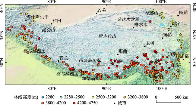
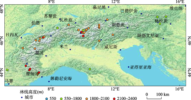
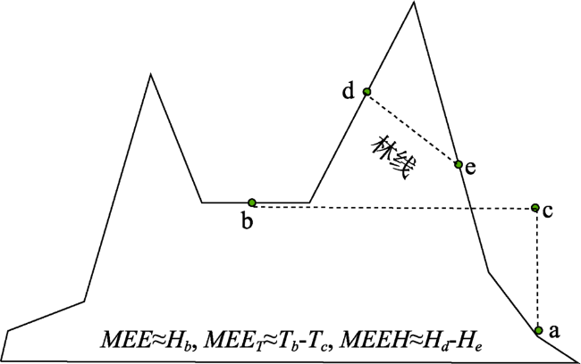
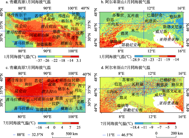
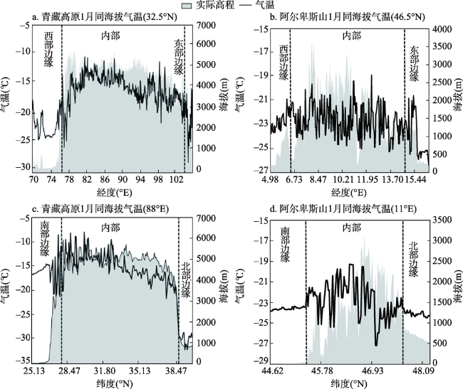
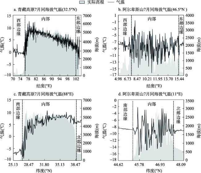
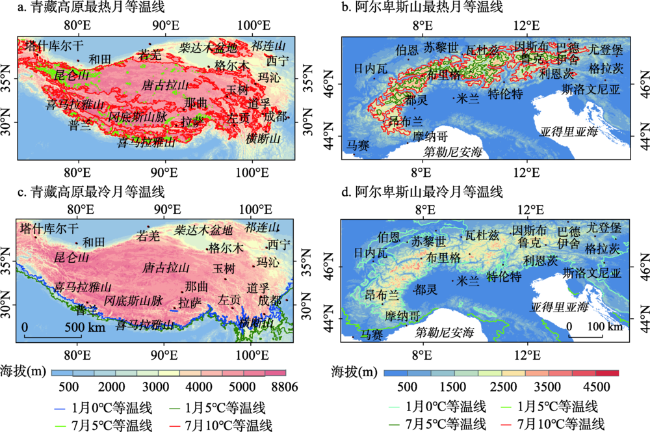
山体效应不仅对气候产生重大影响,也对区域地理生态格局有深远影响,尤其是它对山地垂直带分布和结构类型等的影响已经为地理学家和地植物学家所认识。目前相关研究主要集中在山体效应定量化方面,缺少不同山地山体效应的对比研究,因此对山体效应的区域差异性了解不足。本文选择欧亚大陆上具有明显山体效应的两个山地青藏高原和阿尔卑斯山为研究对象,利用收集到的气象台站观测数据、林线和DEM数据以及基于MODIS地表温度估算的青藏高原和阿尔卑斯山气温数据等,通过对比分析青藏高原与阿尔卑斯山相同海拔高度上的气温以及林线分布高度等来探讨两个山地的山体效应差异性。分析结果表明青藏高原的山体效应比阿尔卑斯山更为强烈,表现为:① 由于山体效应影响,在相同海拔高度上(4500 m),青藏高原内部气温远高于阿尔卑斯山的气温,尤其是在最热月高原内部气温比阿尔卑斯山内部气温高10~15℃,在最冷月高原内部气温比阿尔卑斯山内部气温高5~10℃。② 由于山体效应影响,青藏高原内部林线也远高于阿尔卑斯山内部林线,约高2000~3000 m。本研究将为山体效应的影响因素分析奠定基础,同时对于揭示欧亚大陆山地生态系统格局具有一定的科学意义。
索南东主 , 姚永慧 , 张百平 . 青藏高原和阿尔卑斯山山体效应的对比研究[J]. 地理研究, 2020 , 39(11) : 2568 -2580 . DOI: 10.11821/dlyj020190755
Mountain elevation effect (MEE) not only produces important effect on climate, but also has profound implications for regional geo-ecology pattern. Most researches have been focused on its role as the heat source in summer and its implications for Asian climate, but little has been done on the comparative study of MEE among different mountains and theirs implications for the position of mountain altitudinal belts (MABs). Therefore, there is insufficient understanding of the regional differences of MEE, and the accuracy of the digital model of the mountain effect is not high, which seriously interferes with our understanding of the mechanism of the MEE and its influence on the vertical zone. This article selects the two mountainous regions of Eurasia, the Tibetan Plateau and the Alps, which have obvious mountain effects as the study areas. Using estimated air temperature data, alpine tree line data and ASTER GDEM data, this paper compares air temperature at the same altitude and the distribution heights of alpine tree lines between the two mountains and demonstrates the differences of MEE between the Tibetan Plateau and the Alps. The results indicate that the MEE of the Tibetan Plateau is much more stronger than that of the Alps. Firstly, due to the influence of MEE, at the same altitude (4500 m), the temperature in the Tibetan Plateau is much higher than that in the Alps, especially the temperature of the warmest month in the inner Tibetan Plateau is 10-15°C higher than that in the inner Alps, and the temperature of the coldest month in the inner Tibetan Plateau is 5-10°C higher than that in the inner Alps. Secondly, due to the influence of MEE, the alpine tree line in the inner Tibetan Plateau is also 2000-3000 m higher than that in the inner Alps. This study is a foundation for the analysis of MEE influence factors such as the mountain scale, the mountain structure and the height, and it has certain scientific significance for revealing the pattern of mountain ecosystem in Eurasia.
表1 青藏高原与阿尔卑斯山最热月和最冷月等温线分布高度及林线高度对比Tab. 1 Isotherms of the warmest and coldest months and the heights of tree line in the Tibetan Plateau and the Alps |
| 位置 | 东部边缘 | 内部 | 西部边缘 | ||||
|---|---|---|---|---|---|---|---|
| 青藏高原 | 阿尔卑斯 | 青藏高原 | 阿尔卑斯 | 青藏高原 | 阿尔卑斯 | ||
| 最冷月 | 0℃等温线高度(m) | 1500~2500 | 500~1000 | 3000~3500 | 1000~2000 | 2000~3000 | 800~1000 |
| 5℃等温线高度(m) | 500~1500 | <1000 | ~~ | ~~ | 500~1500 | <1000 | |
| 最热月 | 5℃等温线高度(m) | 4500~5000 | 2000~2500 | 5000~5500 | 2000~3000 | 4000~5000 | 2000~2500 |
| 10℃等温线高度(m) | 3500~4500 | 1500~2000 | 4000~5500 | 2000~2500 | 3500~4000 | 1600~2000 | |
| 林线高度(m) | 3200~3800 | 1600~1700 | 4000~4900 | 2000~2400 | 3200~3800 | 1800~2000 | |
| [1] |
|
| [2] |
|
| [3] |
|
| [4] |
吴国雄, 刘屹岷, 刘新, 等. 青藏高原加热如何影响亚洲夏季的气候格局. 大气科学, 2005,29(1):47-57.
[
|
| [5] |
|
| [6] |
|
| [7] |
|
| [8] |
|
| [9] |
|
| [10] |
|
| [11] |
叶笃正, 罗四维, 朱抱真. 西藏高原及其附近的流场结构和对流层大气的热量平衡. 气象学报, 1957,28(2):108-121.
[
|
| [12] |
|
| [13] |
姚永慧, 徐美, 张百平. 青藏高原增温效应对垂直带谱的影响. 地理学报, 2015,70(3):407-419.
[
|
| [14] |
姚永慧, 张百平, 韩芳. 基于Modis地表温度的横断山区气温估算及其时空规律分析. 地理学报, 2011,66(7):917-927.
[
|
| [15] |
姚永慧, 张百平. 青藏高原气温空间分布规律及其生态意义. 地理研究, 2015,34(11):2084-2094.
[
|
| [16] |
|
| [17] |
|
| [18] |
王婧, 张百平, 张文杰, 等. 科罗拉多落基山脉山体效应定量化研究山体. 地理研究, 2017,36(8):71-81.
[
|
| [19] |
张朔. 山体效应主要形成因素及其定量化研究. 北京: 中国科学院大学博士学位论文, 2015.
[
|
| [20] |
韩芳, 张百平, 谭靖, 等. 山体基面高度对青藏高原及其周边地区雪线空间分布的影响. 地理研究, 2014,33(1):23-30.
[
|
| [21] |
贺文慧. 基于垂直带的山体效应数字模拟: 以青藏高原、安第斯山区中段为例. 北京: 中国科学院大学博士学位论文, 2016.
[
|
| [22] |
张百平, 姚永慧, 赵芳, 等. 山体效应研究. 北京: 中国环境科学出版社, 2015: 3-82.
[
|
| [23] |
|
| [24] |
|
| [25] |
|
| [26] |
|
| [27] |
孙然好, 张百平. 山地垂直带谱数字识别的技术实现和图谱构建. 地球信息科学, 2008,10(6):690-696.
[
|
| [28] |
张百平, 姚永慧, 莫申国, 等. 数字山地垂直带谱及其体系的探索. 山地学报, 2002,20(6):660-665.
[
|
| [29] |
张百平, 周成虎, 陈述彭. 中国山地垂直带信息图谱的探讨. 地理学报, 2003,58(2):163-171.
[
|
| [30] |
张百平, 许娟, 武红智, 等. 中国山地垂直带的数字集成与基本规律分析. 山地学报, 2006,24(2):144-149.
[
|
| [31] |
方精云. 地理要素对我国温度分布影响的数量评价. 生态学报, 1992,12(2):97-104.
[
|
| [32] |
|
| [33] |
|
| [34] |
|
| [35] |
|
| [36] |
缪启龙, 丁园圆, 王勇. 气候变暖对中国亚热带北界位置的影响. 地理研究, 2009,28(3):634-642.
[
|
| [37] |
丘宝剑. 我国亚热带划分中的一些问题. 地理研究, 1984,3(1):66-76.
[
|
| [38] |
|
| [39] |
齐文文, 张百平, 庞宇, 等. 基于TRMM数据的青藏高原降水的空间和季节分布特征. 地理科学, 2013,33(8):999-1006.
[
|
| [40] |
|
| [41] |
|
| [42] |
|
| [43] |
|
| [44] |
|
| [45] |
|
/
| 〈 |
|
〉 |
