
贵州高原北部河流阶地发育与喀斯特地貌演化
|
蒋玺(1977-),男,贵州瓮安人,博士,副教授,硕士生导师,主要研究方向为第四纪地质和环境。E-mail: xjiang@gzu.edu.cn |
收稿日期: 2020-06-05
录用日期: 2020-07-27
网络出版日期: 2021-03-10
基金资助
贵州省科技支撑计划项目(黔科合支撑[2019]2852号)
贵州省科学技术基金项目([2020]1Y164)
中国科学院大学生创新实践训练计划项目(20184000956)
中国科学院大学生创新实践训练计划项目(20194000470)
版权
River terraces in the northern Guizhou Plateau and their implications for karst landform evolution
Received date: 2020-06-05
Accepted date: 2020-07-27
Online published: 2021-03-10
Copyright
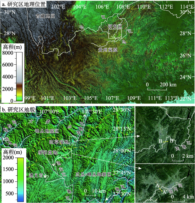
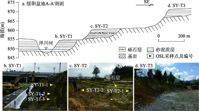
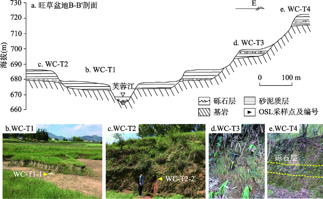
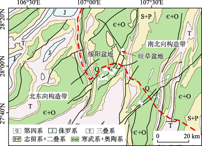
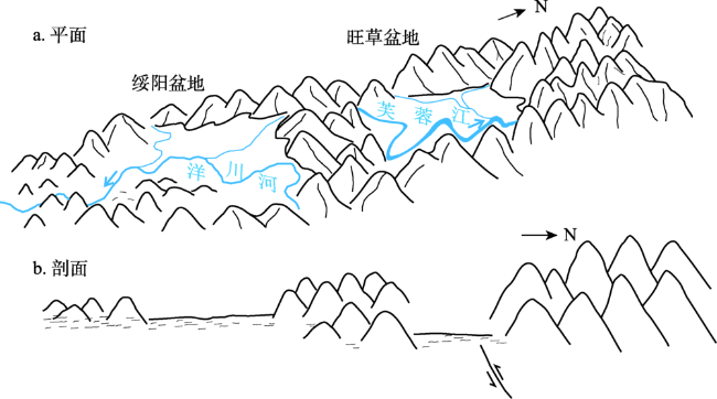
贵州高原北部发育平缓丘丛和深切峰丛2种喀斯特地貌组合,保存于喀斯特山间盆地的河流阶地对区域地貌演化具有指示意义。本文根据阶地发育特征和光释光(OSL)测年,分析阶地形成的时代和动力,结合区域地质背景,探讨构造抬升和河流侵蚀对黔北喀斯特地貌演化的驱动作用。结果显示,绥阳盆地T1阶地时代18.8~8.2 ka,T2时代144.4~104.1 ka;旺草盆地T1年龄为5.5 ka,T2年龄为45.1 ka。绥阳盆地阶地以漫滩相沉积物为主,旺草盆地阶地则多切割了白云岩基岩。分析认为,气候条件影响了阶地的沉积过程,但差异性构造抬升应为区域河流阶地差异发育的主要因素。阶地测年显示,旺草盆地的河流平均下切速率明显高于绥阳盆地,表明芙蓉江流域构造抬升和河流下切强度明显高于洋川河。在差异性构造抬升和河流侵蚀综合作用下,北部大娄山区形成了深切的喀斯特峰丛-峡谷地貌,南部乌江中游流域则发育以平坦盆地和宽缓丘丛为主的地貌组合。
蒋玺 , 陈文奇 , 宁凡 , 孙玉慧 , 敖进 , 罗维均 , 况光显 . 贵州高原北部河流阶地发育与喀斯特地貌演化[J]. 地理研究, 2021 , 40(1) : 81 -92 . DOI: 10.11821/dlyj020200485
Geologists pay much attention to mountainous geomorphic evolution of Guizhou Plateau, because of its core region of karst area in Southwest China. There are two different geomorphic blocks in the northern Guizhou Plateau, which is representative for the karst landforms in Guizhou. River terraces in the karst intermontane basin, as an important step-like landform system in this area, are of great significance for the study of regional geomorphic evolution. In this work, we studied sediment characteristics and optical stimulated luminescence (OSL) dating of the terraces in the Suiyang Basin and the Wangcao Basin in the northern Guizhou Plateau. And then, the terrace ages and associated evolutionary dynamics of Guizhou Plateau have been discussed. Combining the terrace development and geological background, we explored karst landform evolution of northern Guizhou Plateau. It is found that in the Suiyang Basin, the ages of terrace are ranged between 18.8 ka-8.2 ka for T1 and 144.4 ka-104.1 ka for T2. In the Wangcao Basin, the ages of terrace are 5.5 ka for T1 and 45.1 ka for T2. In the Suiyang Basin, the terraces mainly deposited floodplain sandy sediments, while the terraces in the Wangcao Basin mostly cut the thick dolomite bedrock. The dating results show that in the formation stage of terrace T1, the average cutting rate of the Furong River in Wangcao Basin is 1.67 m/ka, significantly greater than that of the Yangchuan River in the Suiyang Basin, which is 0.35 m/ka. According to dating and regional geological correlation, we hold that climate change may affect the sedimentary characteristics of the terraces, but tectonic uplift is the dominant driving force for terrace formation. Different terrace ages are the results of differential uplifts in the Guizhou Plateau. Based on the terrace characteristics and dating, we found that tectonic uplift and river undercutting in the Wangcao Basin were more intensive than those in the Suiyang Basin. Actively driven by differential tectonic uplift and river erosion, the karst deep-cutting gorges and peak clusters landform is formed in the Furong River Basin, a part of Dalou Mountain, while the flat intermontane basins and hill clustered landform has been developed in the middle reaches of Wujiang River Basin.
Key words: Guizhou Plateau; river terrace; OSL dating; karst; landform evolution
表1 绥阳盆地和旺草盆地河流阶地OSL测年结果Tab. 1 OSL dating results of terrace sediment in Suiyang Basin and Wangcao Basin |
| 样品 编号 | 埋深 (m) | U-238 (Bg/kg) | Ra-226 (Bg/kg) | Th-232 (Bg/kg) | K-40 (Bg/kg) | 含水量 (%) | 环境剂量率 (Gy/ka) | 等效剂量 (Gy) | 年龄 (ka) |
|---|---|---|---|---|---|---|---|---|---|
| SY-T1-1 | 1.0 | 100.0±10.1 | 76.5±1.0 | 65.0±0.7 | 601.8±11.3 | 18 | 4.9±0.2 | 40.2±1.3 | 8.2±0.5 |
| SY-T1-2 | 2.2 | 40.2±6.6 | 22.0±0.5 | 32.9±0.4 | 358.7±7.2 | 15 | 2.4±0.1 | 40.2±1.0 | 16.7±0.8 |
| SY-T1-3 | 2.7 | 22.9±5.9 | 20.4±0.4 | 31.5±0.4 | 348.8±6.8 | 18 | 2.2±0.1 | 40.8±1.4 | 18.8±1.1 |
| SY-T2-1 | 1.1 | 36.3±7.0 | 23.5±0.5 | 50.8±0.6 | 430.4±8.2 | 16 | 3.0±0.1 | 316.7±16.7 | 104.1±7.2 |
| SY-T2-2 | 3.6 | 55.6±7.9 | 32.4±0.6 | 56.8±0.6 | 464.9±9.0 | 32 | 3.0±0.2 | 430.0±8.0 | 144.4±10.7 |
| WC-T1-1 | 0.5 | 44.5±8.4 | 40.3±0.7 | 68.0±0.7 | 863.3±16.7 | 23 | 4.6±0.2 | 28.5±0.8 | 5.5±0.3 |
| WC-T2-2 | 3.6 | 55.3±8.4 | 34.3±0.6 | 71.7±0.7 | 729.3±12.8 | 25 | 4.2±0.2 | 186.2±8.4 | 45.1±3.2 |
注:数据测试由中国地震局地质研究所地震动力学国家重点实验室杨会丽博士完成;测年样品埋深为减除松散表土层的稳定沉积层深度。 |
表2 贵州高原及邻近区域河流阶地沉积时代Tab. 2 Ages of river terraces of Guizhou Plateau and neighboring areas |
| 水系 | 区域 | 阶地 | 拔河高度 (m) | 基座岩性 | 年龄 (ka) | 平均下切速率 (m/ka) |
| 长江水系 | 黔北绥阳盆地 | T1 | 5 | 碳酸盐岩 | 8.2±0.5 (OSL) 16.7±0.8 (OSL) 18.8±1.1 (OSL) | 0.35 |
| T2 | 12 | 碳酸盐岩 | 104.1±7.2 (OSL)) 144.4±10.7 (OSL) | 0.08 | ||
| 黔北旺草盆地 | T1 | 10 | 碳酸盐岩 | 5.5±0.3 (OSL) | 1.67 | |
| T2 | 20 | 碳酸盐岩 | 45.1±3.2 (OSL)) | 0.16 | ||
| 黔中乌当盆地[32] | T1 | 3.6 | 碎屑岩 | 26.7±1.8 (OSL) 23.6±1.8 (OSL)) | 0.11 | |
| T2 | 16~18 | 碎屑岩 | 87.6±6.8 (OSL) 114.0±11.9 (OSL)) 177.4±17.0 (OSL) | 0.21 | ||
| 湘西北张家界[24] | T1 T2 T3 T4 | 4~15 15~33 25~62 78~83 | 碳酸盐岩 碳酸盐岩 碳酸盐岩 碳酸盐岩 | 60.95±5.18 (TL) 104.45±8.88 (TL) 117.62±9.99 (TL) 151.05±12.84 (TL) 201.24±17.11 (TL) 347±34 (ESR) | 0.51 0.24 0.27 0.21 0.32 0.11~0.34 | |
| 长江三峡段[34,35] | T1 T2 T3 T4 | 以碳酸盐岩为主 以碳酸盐岩为主 以碳酸盐岩为主 以碳酸盐岩为主 | 9~31 (14C) 56~59 (U-series) 110~200 (ESR)) 300~500 (TL、ESR) | |||
| 珠江水系 | 黔西南岔河[36]35-50 | T1 | 3 | 碳酸盐岩 | 35.1±3.5 (OSL) | 0.08 |
| T2 | 110~115 | 碳酸盐岩 | 57.4±5.7 (OSL) 61.6±6.2 (OSL) | 4.04 | ||
| 黔南曹渡河[31]88-101 | T1 | 5~10 | 碳酸盐岩 | 8.268±0.14 (14C) | 0.6~1.2 |
注:阶地年龄后括号内为测年方法,OSL代表光释光法;TL代表热释光法;ESR代表电子自旋共振法;14C代表碳十四法;U-series代表U系法。 |
本文得到二位匿名评审专家在图表和文字完善、研究成果讨论等方面的修改建议,以及中国地震局地质研究所地震动力学国家重点实验室杨会丽博士在释光年代样品测定上的帮助和支持,在此对他们付出的时间和精力表示真诚感谢!
| [1] |
王世杰, 张信宝, 白晓永. 中国南方喀斯特地貌分区纲要. 山地学报, 2015,33(6):641-648.
[
|
| [2] |
杨怀仁. 贵州中部之地形发育. 地理学报, 1944,11(0):1-14.
[
|
| [3] |
杨明德. 贵州高原喀斯特地貌的结构及演化规律. 见: 中国地理学会地貌专业委员会. 喀斯特地貌与洞穴. 北京: 科学出版社, 1985: 27-28.
[
|
| [4] |
聂跃平. 贵州中南部地区喀斯特地貌发育的趋势面分析. 南京大学学报(自然科学版), 1994,30(1):154-159.
[
|
| [5] |
崔之久, 李德文, 冯金良, 等. 覆盖型岩溶、风化壳与岩溶(双层)夷平面. 中国科学(D辑), 2001,31(6):510-520.
[
|
| [6] |
李德文, 崔之久, 刘耕年. 湘桂黔滇藏红色岩溶风化壳的发育模式. 地理学报, 2002,57(3):293-300.
[
|
| [7] |
周德全, 刘秀明, 姜立君, 等. 贵州高原层状地貌与高原抬升. 地球与环境, 2005,33(2):79-84.
[
|
| [8] |
金德生, 乔云峰, 杨丽虎, 等. 新构造运动对冲积河流影响研究的回顾与展望. 地理研究, 2015,34(3):437-454.
[
|
| [9] |
刘玉清, 林晓, 王君波, 等. 西藏中部当惹雍错湖泊阶地记录的中晚全新世古气候变化. 地理研究, 2017,36(6):1191-1200.
[
|
| [10] |
|
| [11] |
|
| [12] |
吴环环, 吴学文, 李玥, 等. 黄河共和-贵德段河流阶地对青藏高原东北缘晚期隆升的指示. 地质学报, 2019,93(12):3239-3248.
[
|
| [13] |
|
| [14] |
|
| [15] |
|
| [16] |
|
| [17] |
|
| [18] |
|
| [19] |
李宗发. 贵州喀斯特地貌分区. 贵州地质, 2011,28(3):177-182.
[
|
| [20] |
王旭龙, 卢演俦, 李晓妮. 细颗粒石英光释光测年: 简单多片再生法. 地震地质, 2005,27(4):615-623.
[
|
| [21] |
杨会丽, 陈杰, 刘进峰, 等. 2008年汶川地震相关堆积物的细颗粒石英光释光测年研究. 地震地质, 2011,33(2):413-420.
[
|
| [22] |
|
| [23] |
|
| [24] |
|
| [25] |
|
| [26] |
|
| [27] |
|
| [28] |
|
| [29] |
|
| [30] |
刘芬良, 高红山, 李宗盟, 等. 金沙江巧家-蒙姑段的阶地发育与河谷地貌演化. 地理学报, 2020,75(5):1095-1105.
[
|
| [31] |
林树基, 周启永, 陈佩瑛. 贵州的上新生界. 贵阳: 贵州科技出版社, 1994.
[
|
| [32] |
蒋玺, 陈文奇, 宁凡, 等. 黔中乌当盆地阶地沉积特征及其对盆地演化的指示. 地理研究, 2020,39(6):1242-1254.
[
|
| [33] |
赵井东, 施雅风, 王杰. 中国第四纪冰川演化序列与MIS对比研究的新进展. 地理学报, 2011,66(7):867-884.
[
|
| [34] |
|
| [35] |
向芳, 朱利东, 王成善, 等. 长江三峡阶地的年代对比法及其意义. 成都理工大学学报(自然科学版), 2005,32(2):162-166.
[
|
| [36] |
胡智丹. 贵州兴义地区活动构造及其对地貌的影响. 成都: 成都理工大学硕士学位论文, 2017.
[
|
| [37] |
贵州省地质调查院. 贵州省区域地质志: 下册. 北京: 地质出版社, 2018: 1117-1151.
[ Guizhou Geological Survey. Regional Geology of Guizhou Province: Book 2. Beijing: Geological Publishing House, 2018: 1117-1151.]
|
| [38] |
李兴中. 晚新生代贵州高原喀斯特地貌演进及其影响因素. 贵州地质, 2001,18(1):29-36.
[
|
/
| 〈 |
|
〉 |