
西北干旱区不稳定耕地概念与分类研究——以新疆昌吉州为例
|
张红旗(1963-),男,黑龙江佳木斯人,博士,研究员,博士生导师,研究方向为土地资源评价与土地资源空间优化配置、土地利用变化及其环境效应、土地利用可持续管理等。E-mail: zhanghq@igsnrr.ac.cn |
收稿日期: 2020-09-07
录用日期: 2021-01-11
网络出版日期: 2021-05-10
基金资助
国家自然科学基金项目(41561070)
版权
Concept and classification of unstable farmland in arid area ofNorthwest China: A case study of Changji Prefecture, Xinjiang
Received date: 2020-09-07
Accepted date: 2021-01-11
Online published: 2021-05-10
Copyright
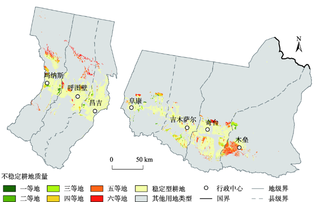
厘清西北干旱区不稳定耕地的资源清单对于维持区域生态平衡至关重要。当前,全国对不稳定耕地的定义和分类比较笼统,难以突出西北干旱区不稳定耕地的特征。本文阐明了西北干旱区不稳定耕地的概念,并根据不稳定因素构建了分类体系。同时以昌吉州为例,分析不稳定耕地的数量、质量与空间分布。结果表明:① 昌吉州不稳定耕地面积为14.56万hm2,占耕地总面积的22.37%。生态不稳定型、生产不稳定型、混合不稳定型和社会经济不稳定型分别占不稳定耕地总面积的36.54%、34.03%、17.94%和11.49%。② 昌吉州不稳定耕地以低等地为主,四至六等地合计占不稳定耕地总面积的79.96%。研究结果可为西北干旱区不稳定耕地的深入理解提供参考,同时为案例地区耕地资源的有效管理提供科技支撑。
张红旗 , 李达净 . 西北干旱区不稳定耕地概念与分类研究——以新疆昌吉州为例[J]. 地理研究, 2021 , 40(3) : 597 -612 . DOI: 10.11821/dlyj020200846
It is essential to clarify the resource list of unstable cultivated land for maintaining ecological balance, ensuring regional food security and promoting the sustainable development of economy and society in the arid areas of Northwest China. At present, the definition and classification of unstable cultivated land in China is relatively general, and the resource endowment of different regions is quite different, so it is difficult to highlight the characteristics of unstable cultivated land in the arid areas of Northwest China with a national standard classification system. In this paper, the connotation and concept of the unstable cultivated land in the arid areas of Northwest China were expounded, and the classification system was constructed according to the unstable factors. Taking Changji Prefecture as a typical case, this paper analyzed the quantity, quality and spatial distribution of unstable cultivated land. The main results are as follows. (1) The definition of unstable cultivated land in the arid areas of Northwest China is as follows: limited by ecological factors (desertification, soil salinization, etc.), or production factors (water, soil, etc.), or socio-economic factors (location, farmland infrastructure, etc.), it is difficult to stabilize production, and continuous cultivation will threaten ecological security of cultivated land ecosystem and surrounding environment, and there is uncertainty in the follow-up land use types. Unstable cultivated land can be divided into four types: productive unstable type, ecological unstable type, socio-economic unstable type and mixed unstable type. (2) The area of unstable cultivated land was 14.56 ten thousand hm2 in Changji Prefecture, accounting for 22.37% of the total cultivated land area. Ecological unstable type, productive unstable type, mixed unstable type, and socio-economic unstable type accounted for 36.54%, 34.03%, 17.94% and 11.49% of the total area of unstable cultivated land, respectively. (3) The unstable cultivated land was mainly at low-grade level in Changji Prefecture, and the fourth to sixth grade cultivated land accounted for 79.96% of the total area of unstable cultivated land. Our results are of great significance for the deep understanding of the unstable cultivated land in the arid areas of Northwest China, and provide scientific support for the effective management of cultivated land resources in the case area.
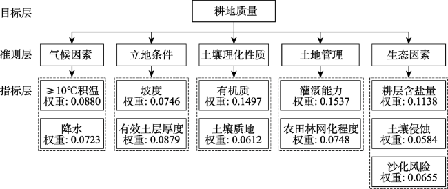
表1 西北干旱区不稳定耕地分类及提取原则Tab. 1 Classification and extraction principle of unstable farmland in arid area of Northwest China |
| 一级 | 二级 | 提取原则 |
|---|---|---|
| 生产不稳 定型 | 灌溉能力不稳定型 | 灌溉能力=不满足且年均降水量<350 mm |
| 排水能力不稳定型 | 排水能力=不满足 | |
| 坡度不稳定型 | 坡度>6° | |
| 有效土层厚度不稳定型 | 有效土层厚度<40 cm | |
| 生态不稳 定型 | 地下水埋深不稳定型 | 地下水埋深<1.2 m;水源类型=地下水且埋深>200 m |
| 沙化风险不稳定型 | 与沙漠距离<5 km且满足后面三个条件之一:① 土壤类型=风沙土;② 水源类型为地下水;③ 农田防护林体系不完善 | |
| 土壤盐渍化不稳定型 | 耕层含盐量>6 g/kg | |
| 土壤侵蚀不稳定型 | 土壤侵蚀模数>2500 t/(km2·a) | |
| 社会经济 不稳定型 | 交通可达性不稳定型 | 与村庄距离>5 km |
| 产量期望不稳定型 | 实收产量/目标产量<0.5 | |
| 农田基础设施不稳定型 | 农田基础设施=不满足 | |
| 混合不稳 定型 | 通过对生产不稳定型、生态不稳定型和社会经济不稳定型的二级类进行空间叠加提取,如灌溉能力+交通可达性不稳定型 | |
注:①本文将灌溉能力、排水能力和农田基础设施分为四个级别,分别为充分满足、满足、基本满足和不满足。在此基础上,将灌溉能力、排水能力和农田基础设施不满足农业生产需求的耕地纳入不稳定耕地。②目标产量为专家指导农户科学施肥过程中,根据作物品种产量潜力和土壤的生产能力为农民推荐的产量指标;实收产量为实际收获的产量。 |
表2 昌吉州不稳定耕地一级类面积及比例统计Tab. 2 The area and proportion of first class of unstable farmland in Changji Prefecture |
| 一级类 | 面积(hm2) | 占比(%) |
|---|---|---|
| 生产不稳定型 | 49560.19 | 34.03 |
| 生态不稳定型 | 53206.85 | 36.54 |
| 社会经济不稳定型 | 16738.74 | 11.49 |
| 混合不稳定型 | 26130.91 | 17.94 |
表3 昌吉州不稳定耕地二级类面积及比例统计Tab. 3 The area and proportion of secondary class of unstable farmland in Changji Prefectu |
| 一级类 | 二级类 | 面积 (hm2) | 占不稳定耕地 总面积比例(%) | 占一级类总 面积比例(%) |
|---|---|---|---|---|
| 生产不 稳定型 | 灌溉能力不稳定型 | 32380.00 | 22.23 | 65.33 |
| 坡度不稳定型 | 8588.36 | 5.90 | 17.33 | |
| 有效土层厚度不稳定型 | 7001.37 | 4.81 | 14.13 | |
| 灌溉能力+坡度不稳定型 | 977.13 | 0.67 | 1.97 | |
| 排水能力不稳定型 | 554.11 | 0.38 | 1.12 | |
| 灌溉能力+有效土层厚度不稳定型 | 59.23 | 0.04 | 0.12 | |
| 生态不 稳定型 | 沙化风险不稳定型 | 25675.93 | 17.63 | 48.26 |
| 地下水埋深不稳定型 | 11882.71 | 8.16 | 22.33 | |
| 土壤盐渍化不稳定型 | 5344.48 | 3.67 | 10.04 | |
| 地下水埋深+沙化风险不稳定型 | 5240.60 | 3.60 | 9.85 | |
| 沙化风险+土壤侵蚀不稳定型 | 3341.42 | 2.29 | 6.28 | |
| 土壤侵蚀不稳定型 | 1403.02 | 0.96 | 2.64 | |
| 地下水埋深+沙化风险+土壤侵蚀不稳定型 | 276.75 | 0.19 | 0.52 | |
| 土壤盐渍化+土壤侵蚀不稳定型 | 41.93 | 0.03 | 0.08 | |
| 社会经济 不稳定型 | 交通可达性不稳定型 | 6811.80 | 4.68 | 40.69 |
| 产量期望不稳定型 | 6253.09 | 4.29 | 37.36 | |
| 农田基础设施不稳定型 | 3455.96 | 2.37 | 20.65 | |
| 产量期望+交通可达性不稳定型 | 216.69 | 0.15 | 1.29 | |
| 产量期望+农田基础设施不稳定型 | 0.83 | 0.00 | 0.00 | |
| 交通可达性+农田基础设施不稳定型 | 0.38 | 0.00 | 0.00 | |
| 混合不 稳定型 | 灌溉能力+农田基础设施不稳定型 | 8708.34 | 5.98 | 33.33 |
| 灌溉能力+坡度+农田基础设施不稳定型 | 3084.46 | 2.12 | 11.80 | |
| 灌溉能力+交通可达性不稳定型 | 2156.59 | 1.48 | 8.25 | |
| 有效土层厚度+沙化风险不稳定型 | 1917.24 | 1.32 | 7.34 | |
| 灌溉能力+产量期望+农田基础设施不稳定型 | 1848.49 | 1.27 | 7.07 | |
| 灌溉能力+交通可达性+农田基础设施不稳定型 | 1191.32 | 0.82 | 4.56 | |
| 有效土层厚度+沙化风险+交通可达性不稳定型 | 895.46 | 0.61 | 3.43 | |
| 其它不稳定型(31种) | 6329.02 | 4.35 | 24.22 |
表4 昌吉州不稳定质量统计Tab. 4 The quality of unstable farmland in Changji Prefecture |
| 类型 | 等级 | 面积 (hm2) | 占不稳定耕地 总面积比例(%) | 占一级类 总面积比例(%) | 占全州同等级 耕地比例(%) |
|---|---|---|---|---|---|
| 生产不稳定型 | 一等地 | 942.45 | 0.65 | 1.90 | 1.39 |
| 二等地 | 2237.06 | 1.54 | 4.51 | 2.23 | |
| 三等地 | 5173.05 | 3.55 | 10.44 | 3.42 | |
| 四等地 | 14818.33 | 10.17 | 29.90 | 8.38 | |
| 五等地 | 22688.78 | 15.58 | 45.78 | 21.25 | |
| 六等地 | 3700.52 | 2.54 | 7.47 | 7.64 | |
| 生态不稳定型 | 一等地 | 944.57 | 0.65 | 1.78 | 1.39 |
| 二等地 | 3199.23 | 2.20 | 6.01 | 3.20 | |
| 三等地 | 6040.10 | 4.15 | 11.35 | 3.99 | |
| 四等地 | 10928.85 | 7.50 | 20.54 | 6.18 | |
| 五等地 | 16228.15 | 11.14 | 30.50 | 15.20 | |
| 六等地 | 15865.95 | 10.89 | 29.82 | 32.74 | |
| 社会经济不稳定型 | 一等地 | 356.46 | 0.24 | 2.13 | 0.53 |
| 二等地 | 2768.57 | 1.90 | 16.54 | 2.77 | |
| 三等地 | 5697.77 | 3.91 | 34.04 | 3.77 | |
| 四等地 | 6329.62 | 4.35 | 37.81 | 3.58 | |
| 五等地 | 1336.61 | 0.92 | 7.99 | 1.25 | |
| 六等地 | 249.70 | 0.17 | 1.49 | 0.52 | |
| 混合不稳定型 | 一等地 | 207.92 | 0.14 | 0.80 | 0.31 |
| 二等地 | 470.70 | 0.32 | 1.80 | 0.47 | |
| 三等地 | 1434.76 | 0.99 | 5.49 | 0.95 | |
| 四等地 | 5731.39 | 3.94 | 21.93 | 3.24 | |
| 五等地 | 15719.83 | 10.79 | 60.16 | 14.73 | |
| 六等地 | 2566.32 | 1.76 | 9.82 | 5.30 |
真诚感谢二位匿名评审专家在论文评审中所付出的时间和精力。评审专家1建议增加不稳定耕地质量分析,使文章的内容更为完善;评审专家2建议在提取原则中增加社会经济维度,使不稳定耕地提取原则更为全面、结构更为清晰。两位专家的修改意见使本文获益匪浅,再次感谢!
| [1] |
张凤荣. 半干旱草原区“不稳定耕地”该如何利用. 中国自然资源报, 2019-08-29(3).
[
|
| [2] |
郝润梅, 马玲玲. 关于内蒙古半干旱地区弃耕的思考: 以和林格尔县为例. 中国土地科学, 2014,28(10):48-54+96-97.
[
|
| [3] |
|
| [4] |
丁建丽, 王飞. 干旱区大尺度土壤盐度信息环境建模: 以新疆天山南北中低海拔冲积平原为例. 地理学报, 2017,72(1):64-78.
[
|
| [5] |
肖生春, 颜长珍, 田永祯, 等. 阿拉善高原沙漠化土地防治区划与治理对策. 中国沙漠, 2019,39(5):182-192.
[
|
| [6] |
刘吉羽. 基于GlobeLand30的我国西北地区耕地变化及其驱动力分析. 成都: 西南交通大学硕士学位论文, 2015: 25-26.
[
|
| [7] |
杨兴华, 何清, 霍文, 等. 策勒绿洲-荒漠过渡带风沙前沿近地面不同方向的输沙特征. 干旱区研究, 2012,29(6):1100-1104.
[
|
| [8] |
王涛, 徐明. 天山北麓东段小河流域平原区浅层地下水超采区评价. 地下水, 2016,38(5):37-39.
[
|
| [9] |
杨凤荣. 西北地区节水灌溉的发展途径与措施. 宁夏农林科技, 2010, (6):130-131.
[
|
| [10] |
石玉林, 王立新, 任继周, 等. 新疆人工绿洲建设、盐碱地改良与农林牧业可持续发展. 北京: 中国水利水电出版社, 2013: 5.
[
|
| [11] |
许实, 赵爱栋, 吴一恒, 等. 土地二调不稳定耕地调查评价成果及应用前景分析. 上海国土资源, 2017,38(2):81-86.
[
|
| [12] |
赵爱栋, 许实, 曾薇, 等. 干旱半干旱区不稳定耕地分析及退耕可行性评估. 农业工程学报, 2016,32(17):215-225.
[
|
| [13] |
赵爱栋, 许实, 曾薇, 等. 不稳定耕地利用困境: 基于粮食安全、农民收入和生态安全间的权衡: 以甘肃省景泰县为例. 资源科学, 2016,38(10):1883-1892.
[
|
| [14] |
刘星, 张凤荣. 河湖防洪区内“不稳定耕地”产生原因及认定. 中国土地, 2016, (4):20-21.
[
|
| [15] |
王宏亮. 呼和浩特市不适宜不稳定耕地调查上图评价分析. 西部资源, 2011, (3):68-71.
[
|
| [16] |
中华人民共和国国土资源部. 全国耕地后备资源调查评价工作技术方案. 北京: 中华人民共和国国土资源部, 2014.
[ The Ministry of Land and Resources of the People's Republic of China. The Technical Scheme for the Investigation of Reserve Cultivated Land Reserve Resources. Beijing: The Ministry of Land and Resources of the People's Republic of China, 2014.]
|
| [17] |
中华人民共和国水利部. 中国水利统计年鉴. 北京: 中国水利水电出版社, 2019.
[ Ministry of Water Resources of the People's Republic of China. China Water Statistical Yearbook. Beijing: China Water & Power Press, 2019.]
|
| [18] |
李建国, 濮励杰, 朱明, 等. 土壤盐渍化研究现状及未来研究热点. 地理学报, 2012,67(9):1233-1245.
[
|
| [19] |
王怡菲, 姚顺波, 邓元杰. 渭河流域水土流失治理效率的时空格局演化与影响因素. 地理科学, 2019,39(5):836-846.
[
|
| [20] |
中国科学院新疆生态与地理研究所. 塔里木河流域整治及生态环境保护研究. 乌鲁木齐: 中国科学院新疆生态与地理研究所, 1999.
[ Xinjiang Institute of Ecology and Geography, Chinese Academy of Sciences. Study on Regulation and Ecological Environment Protection of Tarim River Basin. Urumqi: Xinjiang Institute of Ecology and Geography, Chinese Academy of Sciences, 1999.]
|
| [21] |
陈文芳. 中国典型地区地下水位控制管理研究. 北京: 中国地质大学硕士学位论文, 2010: 59.
[
|
| [22] |
谢辉, 古丽尼莎, 孙振海, 等. 昌吉市浅层地下水现状及开发潜力分析. 西部探矿工程, 2013,25(9):137-139+143.
[
|
| [23] |
中华人民共和国水利部. 中国水土保持公报. 北京: 中华人民共和国水利部, 2018.
[ Ministry of Water Resources of the People's Republic of China. Bulletin of China's soil and water conservation. Beijing: Ministry of Water Resources of the People's Republic of China, 2018.]
|
| [24] |
麻海涛. 耕地质量与耕地景观格局的耦合性研究: 以嵊州市为例. 杭州: 浙江大学硕士学位论文, 2018: 38.
[
|
| [25] |
李升发, 李秀彬. 耕地撂荒研究进展与展望. 地理学报, 2016,71(3):370-389.
[
|
| [26] |
杨学涛, 李品芳, 侯振安, 等. 玛纳斯河流域不同地貌单元弃耕地土壤盐分差异研究. 土壤学报, 2012,49(6):1241-1246.
[
|
| [27] |
封玲. 玛纳斯河流域弃耕地诱发的荒漠化及生态重建研究. 古今农业, 2007, (2):1-8.
[
|
/
| 〈 |
|
〉 |

