
近三十年青藏高原内流区湖泊岸线形态的时空演变
|
王哲(2000-),男,江苏连云港人,主要研究方向为GIS算法与空间分析等研究。E-mail: congquejj@gmail.com |
收稿日期: 2021-03-05
录用日期: 2021-09-01
网络出版日期: 2022-06-10
基金资助
中国科学院战略性先导科技专项(XDA23100102)
第二次青藏高原综合科学考察研究项目(2019QZKK0202)
国家自然科学基金项目(41971403)
国家自然科学基金项目(41930102)
国家自然科学基金项目(42171421)
版权
Spatiotemporal changes of lake shoreline morphology in Tibetan Plateau during 1990-2018
Received date: 2021-03-05
Accepted date: 2021-09-01
Online published: 2022-06-10
Copyright
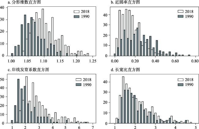
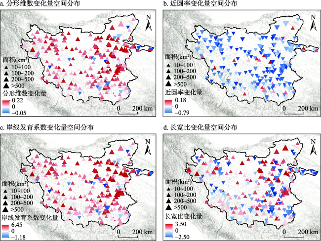
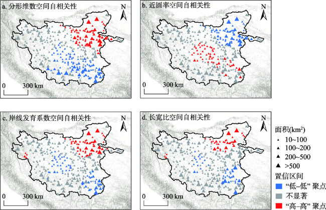
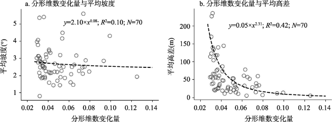
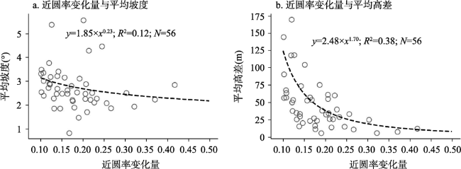
湖泊岸线形态是描述和定量表达湖泊空间分布特征的重要维度。近年来,受气候暖湿化影响,青藏高原内流区湖泊总体呈现快速扩张趋势,湖泊的动态变化不仅体现在面积、水位、水量等水文参数上,还引起湖泊形态的显著变化。基于多期湖泊分布数据,结合分形和景观生态学理论,构建了湖泊岸线形态特征量化的指标体系,对1990年以来,青藏高原内流区湖泊岸线形态的时空变化特征及其影响因素进行定量分析。结果表明:① 近三十年来青藏高原内流区湖泊的分形维数和岸线发育系数总体呈上升趋势,湖泊的近圆率在此期间呈下降趋势,湖泊长宽比指数则无明显变化。② 青藏高原内流区湖泊岸线形态的总体演变特征受到地质构造的控制,体现出一定空间自相关性,断陷湖区的湖泊岸线形态及其变化要明显复杂于坳陷湖区。区域湖泊岸线的变化幅度大致从东北向西南递减,变化幅度在可可西里地区、羌塘高原中部以及羌塘高原东南部3个区域存在空间自相关性。③ 湖泊岸线形态的变化受岸线周边的地形影响,湖滨地形落差较大的区域,湖泊岸线相对稳定,变化速度较慢。岸线指数的变化量与岸线周边1 km缓冲区内的平均高差存在幂函数关系。④ 该区域湖泊岸线形态的变化和湖泊面积的变化幅度也存在一定相关性,当湖泊处于扩张阶段时,湖泊的分形维数和岸线发育系数总体呈现增加趋势,反之减少。本研究揭示了气候暖湿化背景下青藏高原内流区湖泊岸线形态的变化格局与影响特征,讨论了湖泊岸线形态及其变化格局与湖区的地质构造,气候与水文等多个要素间的关系,丰富了湖泊动态变化研究的视角与方法,为深入理解青藏高原湖泊对气候变化的响应特征,监测湖泊变化对湖盆地貌、水系连通度以及湖滨带生态环境等影响提供了科学参考。
王哲 , 刘凯 , 詹鹏飞 , 王纯 , 范辰媛 , 宋春桥 , 汤国安 . 近三十年青藏高原内流区湖泊岸线形态的时空演变[J]. 地理研究, 2022 , 41(4) : 980 -996 . DOI: 10.11821/dlyj020210176
Lake shoreline morphology is an important dimension to describe and quantitatively express the spatial distribution characteristics of lakes. In recent years, affected by climate warming and humidification, lakes in the interior drainage area of the Tibetan Plateau generally showed a rapid expansion. The dynamic changes of lakes are reflected in lake hydrological parameters, including area, water level and water volume, and cause significant changes in lake morphology. Based on multi-period lake distribution data, we construct a quantitative index system of lake shoreline morphology by combining the fractal and landscape ecology theory, and quantitatively analyzes the spatiotemporal variation characteristics of lake shoreline morphology and its influencing factors in the interior drainage area of the Tibetan Plateau since 1990. The results show that: (1) In the last 30 years, the fractal dimension and shoreline development index of lakes in the study area have shown an increasing trend, while the circularity ratio has shown a decreasing trend during this period, and the aspect ratio has not changed significantly. (2) The overall characteristics of lake shoreline are determined by geological structure. The lake shoreline and its changes in the fault lake area are obviously more complex than those in the depression lake area. The rangeability of lake shoreline in the area roughly descends from northeast to southwest, showing spatial auto-correlation in the Hoh Xil region, and central and southeastern Qiangtang Plateau. (3) There is a certain correlation between the change of lake shoreline and the change of lake area. When the lake is in the state of expansion, the fractal dimension and shoreline development index of the lake will increase, and vice versa. (4) The variation of the lake shoreline is affected by the landforms around. In the area with a large drop of lakeside terrain, the lake shoreline is relatively stable and the change speed is low. The variation of shoreline has a power function relationship with the average elevation difference in the buffer zone of 1 kilometer around the shoreline. This study reveals the change patterns and influence characteristics of lake shoreline morphology in the interior drainage area of the Tibetan Plateau under the influence of climate warming and humidification, discusses the relationship between the shoreline and its change pattern and the geological structure, climate and hydrology, modifies the methods of studies on dynamic change in lakes, and provides a new scientific perspective for thoroughly understanding the response of the Tibetan lakes to climate change and monitoring the impact of lake changes on hydrogeomorphic features.
表1 不同时期内青藏高原内流区湖泊统计数据Tab. 1 Statistical data of lakes in interior drainage area of the Tibetan Plateau in different periods |
| 年度 | 湖泊数量 (≥10 km2) | 面积 (≥10 km2) | 各个面积区间内的湖泊数量和面积(km2) | |||||||
|---|---|---|---|---|---|---|---|---|---|---|
| 10~100 | 100~200 | 200~500 | >500 | |||||||
| 1990 | 273 | 24695.79 | 216 | 7244.10 | 26 | 2798.27 | 24 | 7444.60 | 7 | 7208.82 |
| 1995 | 272 | 23726.02 | 218 | 7205.59 | 26 | 2764.88 | 21 | 6342.40 | 7 | 7413.15 |
| 2000 | 294 | 26692.44 | 238 | 8232.45 | 27 | 3450.12 | 20 | 6028.22 | 9 | 8981.66 |
| 2005 | 296 | 29317.17 | 231 | 8362.23 | 34 | 4560.22 | 20 | 6222.91 | 11 | 10171.81 |
| 2010 | 304 | 30820.15 | 232 | 8085.15 | 40 | 5230.29 | 22 | 7034.85 | 10 | 10469.86 |
| 2015 | 297 | 31558.18 | 225 | 8082.26 | 41 | 5551.11 | 19 | 6092.94 | 12 | 11831.87 |
| 2018 | 328 | 34082.14 | 247 | 8594.96 | 46 | 6147.77 | 24 | 7821.77 | 11 | 11517.65 |
表2 湖泊岸线特征量化指标体系Tab. 2 Quantitative index system of lake shoreline characteristics |
| 分类 | 名称 | 计算公式 | 描述 | 含义 |
|---|---|---|---|---|
| 岸线基本指标 | 面积(m2) | A | A为湖泊面积 | 湖泊水域所占空间大小 |
| 周长(m) | P | P为湖泊周长 | 湖泊岸线的总长度 | |
| 岸线形态指标 | 近圆度 | A为湖泊面积 P为湖泊周长 | 反映空间离散程度。近圆率越小,水面岸线曲率越大,形态周长就越长。 | |
| 长宽比 | L为最长轴长度 W为最短轴长度 | 反映湖泊宏观形态。长宽比较高的湖泊,形态相对狭长。 | ||
| 岸线复杂指标 | 岸线发育系数 | A为湖泊面积 为湖泊岸线长度 | 岸线景观越丰富,其湖泊岸线在形态上越多变,岸线的发育系数越大。 | |
| 周长-面积维数 | C为系数;T为推绎指数,值是岸线分形维数的一半 | 用于对多个湖泊岸线的分形维数的获取。 |
表3 湖泊岸线形态指标变化值的全局自相关性计算结果Tab. 3 The global autocorrelation calculation results of the variation values of lake shoreline morphological indexes |
| 指数名称 | Moran's I | Z-score | P-value | |||||
|---|---|---|---|---|---|---|---|---|
| 年份 | 2018 | 1990 | 2018 | 1990 | 2018 | 1990 | ||
| 分形维数 | 0.670 | 0.454 | 6.192 | 3.791 | 0.000 | 0.000 | ||
| 岸线发育系数 | 0.607 | 0.351 | 5.641 | 3.790 | 0.000 | 0.000 | ||
| 近圆率 | 0.437 | 0.294 | 2.798 | 2.230 | 0.007 | 0.021 | ||
| 长宽比 | 0.151 | 0.210 | 1.892 | 2.294 | 0.058 | 0.021 | ||
真诚感谢匿名评审专家在论文评审中所付出的时间和精力。专家对于文章的观察视角,研究方法,以及行文规范等方面均给出了宝贵的意见和经验,对于文章质量的提升有着重要的帮助。
| [1] |
徐昔保, 杨桂山, 江波. 湖泊湿地生态系统服务研究进展. 生态学报, 2018,38(20):7149-7158.
[
|
| [2] |
|
| [3] |
秦伯强, 高光, 朱广伟, 等. 湖泊富营养化及其生态系统响应. 科学通报, 2013,58(10):855-864.
[
|
| [4] |
李云良, 张奇, 姚静, 等. 鄱阳湖湖泊流域系统水文水动力联合模拟. 湖泊科学, 2013,25(2):227-235.
[
|
| [5] |
|
| [6] |
|
| [7] |
马荣华, 杨桂山, 段洪涛, 等. 中国湖泊的数量, 面积与空间分布. 中国科学: 地球科学, 2011,41(3):394-401.
[
|
| [8] |
王苏民, 窦鸿身. 中国湖泊志. 北京: 科学出版社, 1998.
[
|
| [9] |
中国科学院南京地理与湖泊研究所. 中国湖泊调查报告. 北京: 科学出版社, 2019.
[Nanjing Institute of Geography and Limnology, CAS. Survey Report of Lakes in China. Beijing: Science Press, 2019.]
|
| [10] |
宋春桥, 詹鹏飞, 马荣华. 湖泊水情遥感研究进展. 湖泊科学, 2020,32(5):1406-1420.
[
|
| [11] |
|
| [12] |
|
| [13] |
刘蕾, 臧淑英, 邵田田, 等. 基于遥感与GIS的中国湖泊形态分析. 国土资源遥感, 2015,27(3):92-98.
[
|
| [14] |
李新国, 江南, 王红娟, 等. 近30年来太湖流域湖泊岸线形态动态变化. 湖泊科学, 2005, (4):294-298.
[
|
| [15] |
祁苗苗, 姚晓军, 刘时银, 等. 1973—2018年青海湖岸线动态变化. 湖泊科学, 2020,32(2):573-586.
[
|
| [16] |
|
| [17] |
朱立平, 张国庆, 杨瑞敏, 等. 青藏高原最近40年湖泊变化的主要表现与发展趋势. 中国科学院院刊, 2019,34(11):1254-1263.
[
|
| [18] |
万玮, 肖鹏峰, 冯学智, 等. 卫星遥感监测近30年来青藏高原湖泊变化. 科学通报, 2014,59(8):701-714.
[
|
| [19] |
|
| [20] |
朱立平, 彭萍, 张国庆, 等. 全球变化下青藏高原湖泊在地表水循环中的作用. 湖泊科学, 2020,32(3):597-608.
[
|
| [21] |
|
| [22] |
|
| [23] |
|
| [24] |
张国庆. 中国湖泊数据集(1960s—2015). 国家青藏高原科学数据中心, 2019.
[
|
| [25] |
|
| [26] |
|
| [27] |
吴兵, 葛昭攀. 分形理论在地理信息科学研究中的应用. 地理学与国土研究, 2002,18(3):23-26.
[
|
| [28] |
陈彦光. 城市地理研究中的单分形, 多分形和自仿射分形. 地理科学进展, 2019,38(1):38-49.
[
|
| [29] |
高义, 苏奋振, 周成虎, 等. 基于分形的中国大陆海岸线尺度效应研究. 地理学报, 2011,66(3):331-339.
[
|
| [30] |
孙博玲. 分形维数(Fractal dimension)及其测量方法. 东北林业大学学报, 2004,32(3):116-119.
[
|
| [31] |
刘颂, 李倩, 郭菲菲. 景观格局定量分析方法及其应用进展. 东北农业大学学报, 2009,40(12):114-119.
[
|
| [32] |
布仁仓, 胡远满, 常禹, 等. 景观指数之间的相关分析. 生态学报, 2005,25(10):2764-2775.
[
|
| [33] |
李晶, 周自翔. 延河流域景观格局与生态水文过程分析. 地理学报, 2014,69(7):933-944.
[
|
| [34] |
任嘉衍, 刘慧敏, 丁圣彦, 等. 伊河流域景观格局变化及其驱动机制. 应用生态学报, 2017,28(8):2611-2620.
[
|
| [35] |
万义良, 金瑞, 唐建波, 等. 东莞市城镇扩张景观格局变化特征. 经济地理, 2019,39(3):84-92.
[
|
| [36] |
|
| [37] |
|
| [38] |
颜锋华, 金亚秋. 尺度分布的Getis统计对遥感图像特征参量空间自相关性的研究. 中国图象图形学报, 2006,11(2):191-196.
[
|
| [39] |
潘文斌, 黎道丰, 唐涛, 等. 湖泊岸线分形特征及其生态学意义. 生态学报, 2003, (12):2728-2735.
[
|
| [40] |
刘晓惠, 许强, 丁林. 差异抬升:青藏高原新生代古高度变化历史. 中国科学: 地球科学, 2017,47(1):40-56.
[
|
| [41] |
姚永慧, 张百平. 青藏高原气温空间分布规律及其生态意义. 地理研究, 2015,34(11):2084-2094.
[
|
| [42] |
李兰晖, 刘琼欢, 张镱锂, 等. 羌塘高原降水空间分布及其变化特征. 地理研究, 2017,36(11):2047-2060.
[
|
| [43] |
郑绵平, 向军, 魏新俊, 等. 青藏高原盐湖. 北京: 北京科学技术出版社, 1989: 192-236.
[
|
| [44] |
李均力, 盛永伟. 1976—2009年青藏高原内陆湖泊变化的时空格局与过程. 干旱区研究, 2013,30(4):571-581.
[
|
| [45] |
|
| [46] |
马小奇, 卢善龙, 马津, 等. 基于地形参数的湖泊水储量估算方法: 以纳木错为例. 国土资源遥感, 2019,31(4):167-173.
[
|
| [47] |
闾利, 张廷斌, 易桂花, 等. 2000年以来青藏高原湖泊面积变化与气候要素的响应关系. 湖泊科学, 2019,31(2):573-589.
[
|
| [48] |
高鹏文, 李新国, 阿里木江. 博斯腾湖湖岸线时空变化特征. 水资源与水工程学报, 2019,30(4):98-104.
[
|
| [49] |
张凤太, 王腊春, 冷辉, 等. 典型天然与人工湖泊形态特征比较分析. 中国农村水利水电, 2012, (7):38-41.
[
|
| [50] |
|
| [51] |
|
/
| 〈 |
|
〉 |
