
四套全球网格降水数据集在伊朗的适用性评估
|
马帅(1996-),男,宁夏吴忠人,博士研究生,主要研究方向为干旱区气候变化。E-mail: mash21@lzu.edu.cn |
收稿日期: 2021-12-17
录用日期: 2022-06-29
网络出版日期: 2023-01-11
基金资助
国家重点研发计划项目(2018YFA0606404)
国家自然科学基金项目(41877446)
国家自然科学基金项目(42171162)
Evaluation of the applicability of four global grid precipitation datasets in Iran
Received date: 2021-12-17
Accepted date: 2022-06-29
Online published: 2023-01-11
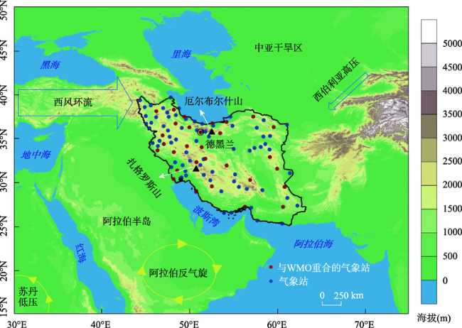
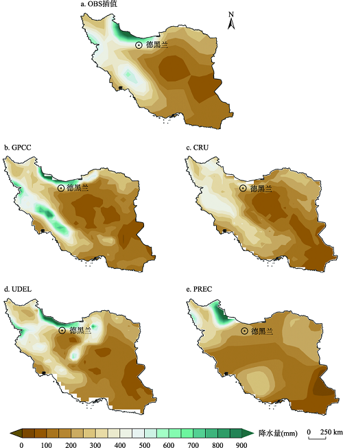
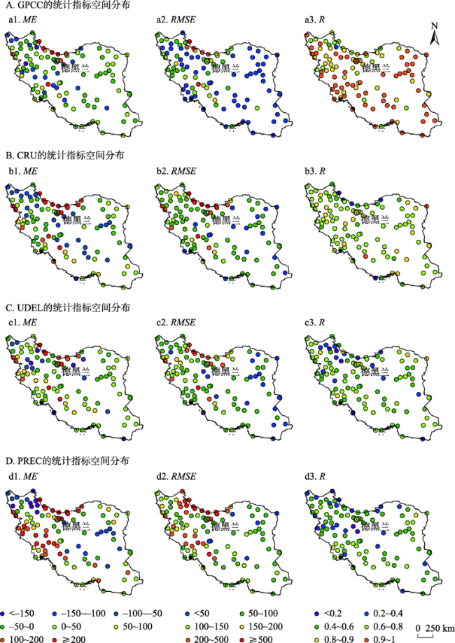
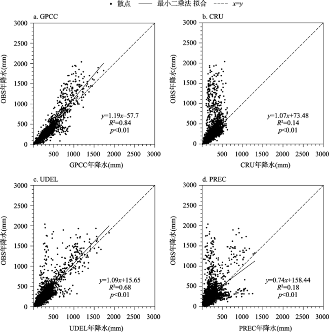
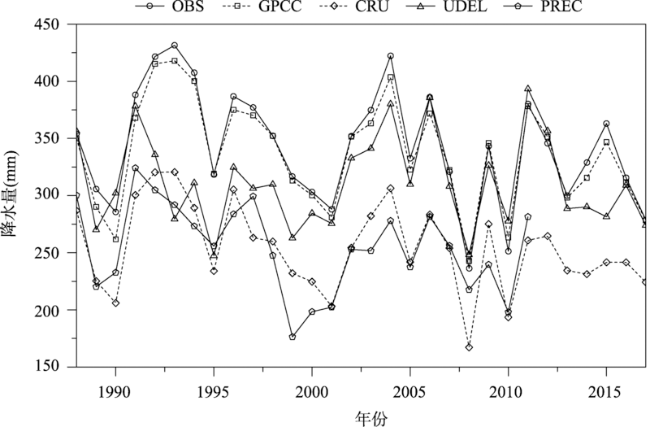
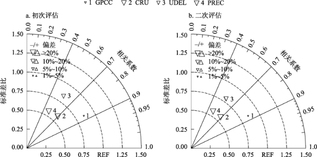
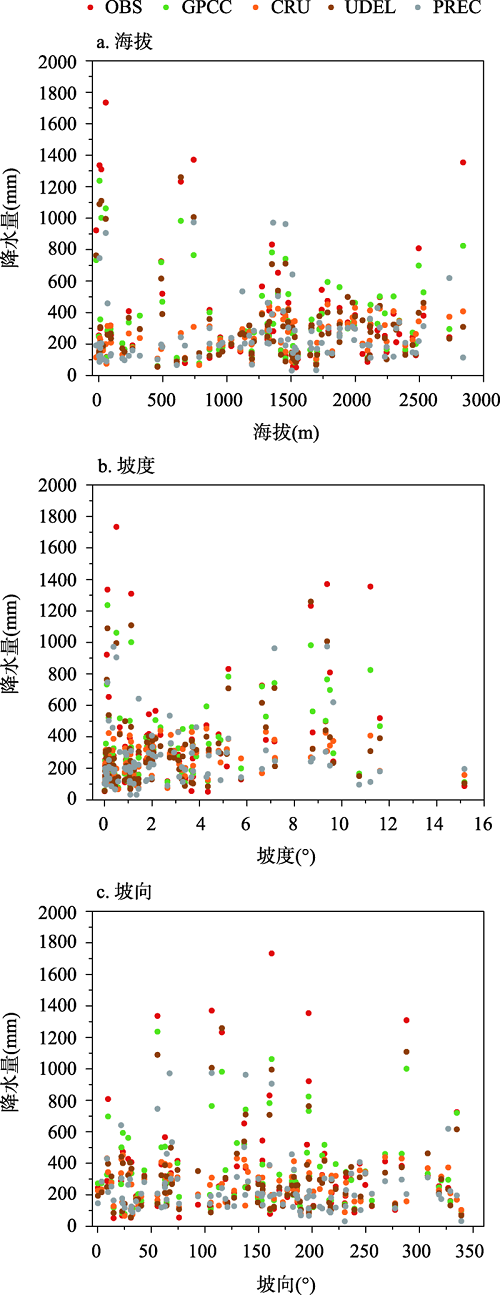
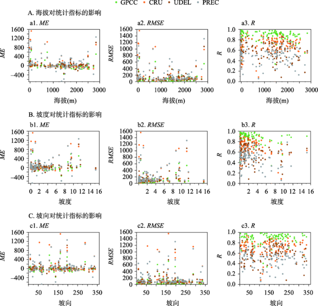
伊朗由于其独特的地理位置和脆弱的生态环境一直以来都是气候变化研究的热点区域,降水作为伊朗水资源的重要来源对生态环境和社会经济发展尤为重要,因此评估降水数据集的适用性是进行科学研究的基础。本文利用伊朗1988—2017年103个观测站的年降水数据(OBS),以平均偏差(Mean Error,ME)、均方根误差(Root Mean Square Error,RMSE)、相关系数(correlation coefficient,R)对Global Precipitation Climatology Centre(GPCC)V2020、Climatic Research Unit(CRU)TS 4.05、Terrestrial Air Temperature and Precipitation: Monthly and Annual Time Series(UDEL)V5.01和NOAA's Precipitation Reconstruction over Land(PREC)四套全球网格降水数据集在伊朗的适用性进行评估,并进一步分析了地形对不同数据集精度的影响。研究结果显示:① GPCC降水数据偏差最小,与观测数据相关性最高,最适合伊朗现代气候变化研究。② GPCC、CRU、和UDEL均能反映伊朗降水的基本特征,但普遍会低估降水高值,PREC数据不能准确反映伊朗降水的空间分布模态,因此使用PREC数据分析伊朗降水特征时应当谨慎。③ 海拔和坡度对ME、RMSE以及R有一定影响,坡向对数据集精度影响不大。以上结论可为四套数据的订正及其在伊朗地区气候变化研究中的应用提供科学依据。
马帅 , 李晨曦 , 刘言 , 陈建徽 , 陈发虎 , 黄伟 . 四套全球网格降水数据集在伊朗的适用性评估[J]. 地理研究, 2022 , 41(11) : 3021 -3035 . DOI: 10.11821/dlyj020211199
Iran is a hot climate change study area due to the unique geographical location and fragile ecological environment. As an important source of water resources, precipitation is crucial to the ecological environment and socio-economic development in Iran. Therefore, the applicability evaluation of precipitation datasets is the basis for conducting scientific research. In this paper, we use the mean error (ME), root mean square error (RMSE), and correlation coefficient (R) to evaluate the applicability of four global gridded precipitation datasets (Global Precipitation Climatology Centre (GPCC) V2020, Climatic Research Unit (CRU) TS 4.05, Terrestrial Air Temperature and Precipitation: Monthly and Annual Time Series (UDEL) V5.01 and NOAA's Precipitation Reconstruction over Land (PREC)) by comparing them with the annual precipitation data from 103 stations in Iran from 1988 to 2017. The effect of terrain on the accuracy of different datasets is also investigated. The results show that: (1) Compared with the other three sets of gridded precipitation data, the GPCC precipitation dataset has the smallest deviation and the highest correlation with the observations (OBS), the trend and change inflection point of the time series are the closest to OBS, which is most suitable for the study of modern climate change. (2) GPCC, CRU, and UDEL precipitation datasets generally underestimate the precipitation with high values, but they can reflect the basic characteristics of precipitation. In contrast, PREC dataset cannot accurately reflect the spatial distribution mode of precipitation. Therefore, it should be cautious to use PREC data to analyze the characteristics of precipitation. (3) Altitude and slope have a certain impact on the accuracy of precipitation datasets. When the altitude exceeds 1500 m, the ME of the dataset increases and R decreases. When the slope is greater than 4°, the ME increases significantly and the R decreases significantly. The four datasets are affected by elevation and slope to a certain degree, and aspect hardly affects the accuracy of these datasets. These results can provide a scientific basis for improving the quality of the four datasets and their application in the study of climate change in Iran.
Key words: Iran; precipitation dataset evaluation; accuracy; altitude; slope
真诚感谢两位匿名评审专家在论文评审中所付出的时间和精力,评审专家对本文引言、结果、科学问题及文章结构方面的修改意见,使本文获益匪浅。
| [1] |
|
| [2] |
吕少宁, 文军, 刘蓉. 中国大陆地区不同降水资料的适用性及其应用潜力. 高原气象, 2011, 30(3): 628-640.
[
|
| [3] |
徐影, 丁一汇, 赵宗慈. 美国NCEP/NCAR近50年全球再分析资料在我国气候变化研究中可信度的初步分析. 应用气象学报, 2001, 12(3): 337-347.
[
|
| [4] |
赵天保, 艾丽坤, 冯锦明. NCEP再分析资料和中国站点观测资料的分析与比较. 气候与环境研究, 2004, 9(2): 278-294.
[
|
| [5] |
|
| [6] |
姜贵祥, 孙旭光. 格点降水资料在中国东部夏季降水变率研究中的适用性. 气象科学, 2016, 36(4): 448-456.
[
|
| [7] |
|
| [8] |
|
| [9] |
|
| [10] |
|
| [11] |
韩振宇, 周天军. APHRODITE高分辨率逐日降水资料在中国大陆地区的适用性. 大气科学, 2012, 36(2): 361-373.
[
|
| [12] |
|
| [13] |
胡增运, 倪勇勇, 邵华, 等. CFSR, ERA-Interim 和 MERRA 降水资料在中亚地区的适用性. 干旱区地理, 2013, 36(4): 700-708.
[
|
| [14] |
|
| [15] |
|
| [16] |
陈发虎, 陈建徽, 黄伟. 中纬度亚洲现代间冰期气候变化的 “西风模式” 讨论. 地学前缘, 2009, 16(6): 23-32.
[
|
| [17] |
|
| [18] |
|
| [19] |
|
| [20] |
|
| [21] |
|
| [22] |
|
| [23] |
|
| [24] |
|
| [25] |
|
| [26] |
|
| [27] |
|
| [28] |
|
| [29] |
|
| [30] |
|
| [31] |
赵天保, 符淙斌, 柯宗建, 等. 全球大气再分析资料的研究现状与进展. 地球科学进展, 2010, 25(3): 242-254.
[
|
| [32] |
|
| [33] |
|
| [34] |
|
| [35] |
|
| [36] |
|
| [37] |
|
| [38] |
|
| [39] |
|
| [40] |
|
| [41] |
孟欣宁, 焦瑞莉, 刘念, 等. 基于随机森林插值的中亚夏季极端高温变化特征. 干旱区研究, 2020, 37(4): 966-973.
[
|
/
| 〈 |
|
〉 |