

1 引言
新生代以来,印度板块不断向北推挤,青藏高原不断隆升并向北东方向扩展增生,目前高原隆升时代、幅度和过程、水系演化以及环境变迁等一直是学者们关注的焦点[1⇓⇓-4],当前关于青藏高原北东向扩展的过程和机制仍未达成一致,有学者根据相关盆地沉积学、热年代学及构造学等研究认为,祁连山的隆升开始于始新世[5]、渐新世[6]和中新世[7],但地学界普遍认为祁连山地区是青藏高原北东向扩展的前缘地带和构造变形的年轻地带。大量研究表明,约15 Ma以来,青藏高原经历逆冲推覆、左旋走滑和侧向挤压等构造变形,朝北东向增生扩展,导致祁连山加速隆升[8⇓-10]。造山带的隆升最终通过流域水系格局及冲积河流河道的调整来响应新构造活动[11,12]。庄浪河流域位于祁连山东段,作为青藏高原北东向扩展的前缘地区,该流域的地貌参数对构造活动非常敏感,流域内及边缘发育庄浪河断裂、天祝盆地南缘断裂、疙瘩沟隐伏断裂以及金强河-毛毛山-老虎山断裂等,与海原断裂和西秦岭北缘断裂存在一定的联系,对庄浪河流域的构造活动有很大影响,导致庄浪河地区曾发生多次中强地震(1440年永登61/4级地震、苦水51/2级地震,1995年的永登5.8级地震等),表明全新世以来庄浪河断裂仍在活动[13]。前人对庄浪河流域水系格局发育特征[14,15]、庄浪河断裂活动速率[16⇓-18]、庄浪河河流阶地发育特征[19⇓-21]开展相关地研究,但对整个流域的地貌演化与构造活动之间的关系研究较少。如何定量化分析庄浪河流域内地貌参数分异规律及其所指示的构造意义,其支流河道形态变化受哪些因素控制,以及如何响应不同的构造活动仍不清楚。
当前,基于数字高程模型(DEM)的构造地貌参数研究,为定量化分析流域内地貌特征提供了可行的技术方法,河流坡降SL、标准河流坡降SL/K、均衡坡降K、Hack剖面以及面积-高程积分值(HI)和积分曲线(HC)是流域地貌定量研究的重要指标,广泛应用于讨论流域地貌发育特征,指示流域构造活动及基岩抗蚀性变化[21⇓⇓⇓⇓-26]。因此,本文以黄河上游一级支流庄浪河为研究对象,基于ArcGIS空间分析技术,以数字高程模型(DEM)为基础数据,通过河流坡降SL、标准河流坡降SL/K、均衡坡降K、Hack剖面、面积-高程积分值HI和面积-高程积分曲线(HC)以及高程条带剖面方法,结合野外地质调查,对定量化研究庄浪河流域的构造活动及地貌演化具有重要意义。
2 研究区概况
2.1 自然地理概况
庄浪河属黄河一级支流,发源于门源盆地与天祝盆地交界位置的冷龙岭,流经天祝盆地和永登盆地,于兰州西固区河口镇汇入黄河,河道大致呈南东向,以天祝为界,分为上游和下游,上游又称金强河,流域北宽南窄,总体呈狭长倒三角状(见图1)。庄浪河属内陆河流,多年平均径流量1.134亿m3,以马家坪气象站为代表,流域多年平均降水量411.3 mm,蒸发量1590.6 mm[27,28]。流域内气候特征存在明显差异性,上游地区属大陆性高原气候,四季不甚分明,蒸发量小,降水的年际变化较大,降水量年内分配不均匀,大体由北西向南东逐渐减少;受地形影响,气温差异较大,海拔递减率为每降低100 m,温度升高0.5℃。天祝境内属牧业区,植被覆盖度相对较好,植被类型较为丰富,以高山草甸、高山灌木林以及高山针叶阔叶混交林为主[29]。下游地区属温带半干旱、干旱气候区,大陆性季风气候显著,气温由南东向北西递减,降水由南东向北西递增,河谷中分布大面积天然林,植被覆盖较好,河谷两侧的山地、丘陵植被覆盖度极低。庄浪河径流量主要来自马雅雪山的冰雪融水和部分大气降水,气候与高程变化有着密切联系,降水随海拔增高而增大,蒸发与温度则随海拔降低减弱或降低[30]。
图1
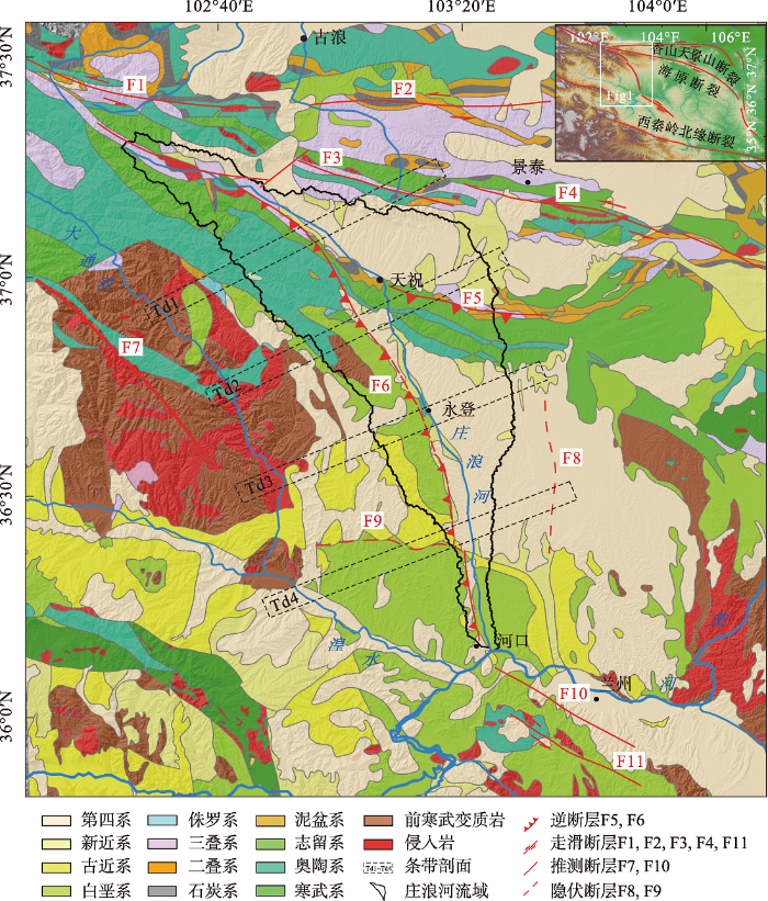
图1
庄浪河流域大地构造位置
注:地质资料参考1:50万地质图(中国地质调查局: www.cgs.gov.cn, 2001),Td1~Td4为条带剖面,F1:冷龙岭断裂,F2:天桥沟-黄羊川断裂,F3:金强河-毛毛山-老虎山断裂,F4:老虎山断裂,F5:天祝盆地南缘断裂,F6:庄浪河断裂,F7:达坂山断裂,F8:秦王川盆地西缘隐伏断裂,F9:疙瘩沟隐伏断裂,F10:金城关断裂,F11:马衔山断裂。
Fig. 1
Geotectonic location map of the Zhuanglang River Drainage Basin
2.2 构造地质概况
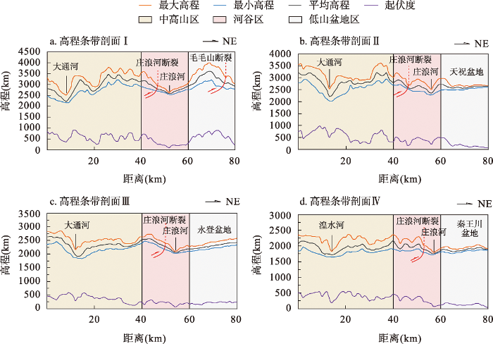
庄浪河流域位于青藏高原东北缘,处在南北地震带与祁连山地震带的复合部位。区内发育一套白垩系河湖相紫红色厚层状砂泥岩互层,新近纪早期构造活动强烈,褶皱变形明显,形成以挤压逆冲-褶皱为主的弧形构造带,背斜脊部白垩系地层内发育多条不同方向的拉张断层[13]。第四纪早期以来多期构造活动导致中新统橙色泥岩产生明显的褶皱变形,将下更新统冲洪积砾岩和中更新统冲洪积黄土卷入其中,并伴随发育有多条晚第四纪强烈活动的断裂带,如庄浪河断裂及其分支疙瘩沟隐伏断裂,主要呈北西西和北北西向延伸[13](见图1)。庄浪河两岸I~IV级河流阶地发育挠曲变形,说明该地区晚新生代以来一直存在构造作用[21]。为更直观地体现庄浪河地区的地形起伏和高程变化情况,沿垂直区域构造线方向绘制了四条长5 km,宽1 km的高程条带剖面。
从高程条带剖面可看出(图2,剖面位置见图1),在横向上有明显的高程变化,庄浪河地区地形起伏总体呈由西向东递减的趋势。根据条带剖面的地貌总体特征,由西向东大致分为三个地形地貌区:①西部中高山区,该区位于庄浪河干流西侧,海拔在2500~3500 m(见图2a),地形起伏较大,山岭、河谷相间分布。②中部河谷区,庄浪河河谷盆地位置,起伏度很小,高程在1500~2200 m,平均高程2130 m(见图2a)。河谷形态以天祝为界,上游河段支流较发育,多宽谷,下游河段支流较少,多峡谷,庄浪河断裂位于庄浪河干流西侧山前,断裂经过处地形起伏大,高差变化明显[14],高差范围为500~1000 m(见图2b~图2d)。③东部低山盆地区,高程在1800~2000 m,地形起伏较小,山区泥沙堆积,土层深厚。较为明显的是庄浪河干流河谷由上游向下逐渐变窄[15]。
图2
3 数据及研究方法
3.1 DEM数据
3.2 河流坡降指标(K、SL、SL/K)与Hack剖面
Hack在研究美国西部河流时,提出河流坡降SL为河流纵剖面坡度与距河流源头距离的乘积[23],即:
式中:ΔH是单位河段的高差;ΔL为单位河段的距离;ΔH/ΔL代表单位河段的坡度;L是该河段中点到分水岭的距离[23]。SL可以用来反映河流纵剖面坡度的变化,常用来讨论中-微观尺度的构造运动或岩性差异等问题[24]。在SL值偏高区域,可能表示该区地层岩性抗侵蚀能力较强,经过长期河流差异侵蚀,使得河流坡度变陡。也可能是由于受到活动构造的影响,造成河段坡度局部变化,使得河流坡降增高。反之,SL值较低区域,可能代表该地区地层岩性抗侵蚀能力较差,河流剖面平缓,也可能代表该地区构造活动性较弱或不受构造作用的影响,实际上,受岩性差异或构造活动的影响,Hack剖面多呈现上凸下凹的曲线状,并非一条直线(见图3a~图3d)[25]。
图3
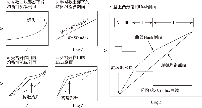
图3
河流坡降指标SL与Hack剖面示意
Fig. 3
Schematic diagram of river slope index SL and Hack profile
Hack剖面以河流纵剖面高度为纵坐标,河段距河流源头的距离取对数为横坐标[23],即:
式中:H表示河流纵剖面的高程;C为常数;K为斜率;L为该河段中点到河流源头的距离。Hack剖面常用于描述河流纵剖面坡度的变化特征[25]。当Hack剖面呈上凸形态时,指示该河段构造活动性较强,Hack剖面呈下凹或直线形态时,指示该河段构造活动性较弱。当流域内地表隆升速率等于或接近下切速率时,Hack剖面呈近直线形态,此时斜率K为均衡坡降指数[33,34]。K值的大小可反映河道的陡缓程度及河流侵蚀力的大小。不同河流的均衡坡降不同,较大的K值反映流域内构造活跃、侵蚀力较强、河道较陡;K值较小,反映流域内构造不活跃、侵蚀力较弱、河道较缓。通常,规模较大的河流有较大的K和SL值,反之亦然。为增强不同河段之间河流坡降的可对比性,对河流坡降指数进行归一化处理,得到标准化坡降指数(SL/K)[35,36]。
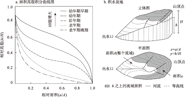
3.3 面积高程积分值(HI)与积分曲线(HC)
式中:Hmean、Hmax和Hmin分别为河道的平均高程、最大高程和最小高程。HC曲线和HI值可定量描述流域地貌演化阶段,也可反映流域内的构造活跃程度[39]。HC曲线与HI值具有很好的对应关系,HC曲线的形态可分为上凸形、S型和下凹形,它们依次对应着地貌发育的幼年期、壮年期和老年期[40⇓~42]。幼年期,地表经迅速造山抬升之后,构造活动作用减弱或停滞,地表因河流侵蚀作用,集水盆地的流域地貌演化早期,主要受构造抬升作用控制,外力作用较弱,地貌受侵蚀切割较弱,土地残积率较大,面积高程积分值大(HI≥0.60),HC曲线呈上凸形态;壮年期,流域演化中期,构造抬升速率与河流下切速率趋于平衡,其面积高程积分值中等(0.35≤HI<0.60),HC曲线呈S型;老年期,流域演化后期,侵蚀程度高,地貌起伏微弱,面积高程积分值较小(HI<0.35),HC曲线呈下凹状态。HI高值反映区域构造活动性较强,HI低值则可能表明区域内构造不活跃或未受强烈构造运动的影响[42]。
图4
4 结果分析
表1 庄浪河流域31条次级河流主要地貌参数
Tab. 1
| 河流编号 | 河流长度L(km) | 流域面积A(km2) | K | SL | SL/K | HI |
|---|---|---|---|---|---|---|
| R1 | 4.21 | 34.52 | 72.25 | 50.76 | 0.69 | 0.40 |
| R2 | 10.70 | 77.38 | 276.17 | 175.68 | 0.68 | 0.37 |
| R3 | 10.16 | 36.23 | 168.08 | 115.67 | 0.60 | 0.32 |
| R4 | 9.82 | 40.21 | 143.96 | 104.33 | 0.79 | 0.28 |
| R5 | 7.60 | 33.75 | 132.27 | 93.58 | 0.71 | 0.32 |
| R6 | 13.45 | 77.28 | 353.64 | 25.02 | 0.07 | 0.38 |
| R7 | 26.58 | 307.83 | 613.62 | 425.39 | 0.71 | 0.39 |
| R8 | 14.65 | 102.37 | 195.88 | 88.11 | 0.45 | 0.39 |
| R9 | 19.37 | 190.08 | 263.22 | 231.23 | 0.88 | 0.39 |
| R10 | 9.64 | 45.39 | 175.77 | 123.35 | 0.70 | 0.50 |
| R11 | 15.65 | 46.31 | 195.88 | 179.80 | 0.81 | 0.51 |
| R12 | 16.59 | 89.64 | 164.99 | 144.47 | 0.88 | 0.51 |
| R13 | 12.04 | 100.20 | 86.83 | 68.09 | 0.78 | 0.50 |
| R14 | 7.39 | 45.79 | 32.41 | 102.06 | 3.15 | 0.40 |
| R15 | 17.58 | 56.05 | 59.44 | 106.60 | 1.79 | 0.45 |
| R16 | 21.23 | 247.21 | 126.42 | 107.37 | 0.85 | 0.44 |
| R17 | 12.83 | 84.78 | 120.95 | 72.35 | 0.60 | 0.29 |
| R18 | 22.97 | 107.05 | 187.19 | 123.49 | 0.66 | 0.31 |
| R19 | 21.55 | 43.34 | 347.40 | 144.47 | 0.88 | 0.41 |
| R20 | 17.22 | 37.15 | 299.78 | 154.98 | 0.52 | 0.48 |
| R21 | 19.38 | 52.15 | 330.87 | 254.85 | 2.28 | 0.53 |
| R22 | 27.33 | 388.92 | 198.17 | 24.93 | 0.13 | 0.31 |
| R23 | 15.07 | 102.61 | 181.32 | 130.63 | 0.72 | 0.43 |
| R24 | 12.40 | 68.27 | 126.42 | 136.81 | 1.08 | 0.30 |
| R25 | 5.59 | 55.10 | 112.35 | 72.08 | 0.65 | 0.34 |
| R26 | 8.17 | 37.46 | 144.29 | 108.46 | 0.75 | 0.36 |
| R27 | 7.19 | 26.13 | 131.51 | 81.53 | 0.62 | 0.30 |
| R28 | 14.25 | 35.33 | 304.35 | 150.42 | 0.49 | 0.36 |
| R29 | 7.72 | 34.01 | 165.20 | 118.04 | 0.71 | 0.29 |
| R30 | 12.21 | 49.59 | 312.46 | 105.02 | 0.34 | 0.35 |
| R31 | 8.27 | 35.86 | 154.56 | 123.63 | 0.80 | 0.49 |
4.1 河流坡降指标(K、SL、SL/K)和Hack的空间分布特征
如图5a(见第269页)所示,K值高值区分布在天祝盆地南缘断裂附(6#,7#,19#,20#,21#)。观察子流域内河流的K值结果(见表1),31个子流域内河流的K值介于32.41~613.62之间,流域内K值空间分布差异极大,K值低值区位于天祝盆地和庄浪河下游河谷两侧,K值分布趋势由上游向下游降低。庄浪河流域内部SL空间变化较大,高值区集中分布在庄浪河下游地区(14#、15#),宝泉山南坡(21#)SL较高(图5b,见第 269页)。SL/K值与SL值分布特征趋于一致,呈由上游向下游衰减的特征(图5b和图5c,见第269页)。分别提取31个子流域中最大河流(R1~R31)和庄浪河的标准河流坡降指数SL/K和Hack剖面(图6见第270页,图7见第271页)。图中显示每条支流的Hack剖面并非平滑的上凸或下凹,而是由凹凸不一的折线组成,其中流域西侧支流(R1~R14)的Hack剖面曲线均呈上凸形态,对应的SL/K也较大;流域东侧部分支流(R21、R22、R23、R24、R26、R27、R28)的Hack剖面出现不同程度的下凹(图7,见第271页),河道坡度变化较小,对应的SL/K也相对较小。标准河流坡降指数SL/K与Hack剖面之间存在较好的地形地貌对应关系,如庄浪河上下游的交界处,Hack剖面陡峻位置对应的SL/K值也出现明显的起伏变化。
图5
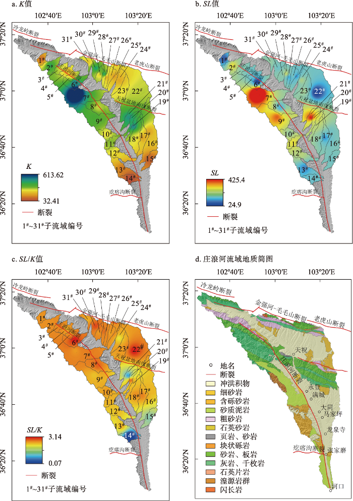
图5
庄浪河流域K、SL、SL/K空间分布图及庄浪河流域地质简图
Fig. 5
Spatial distribution of K, SL, SL/K in the Zhuanglang River Drainage Basin and geological sketchof the Zhuanglang River Drainage Basin
图6
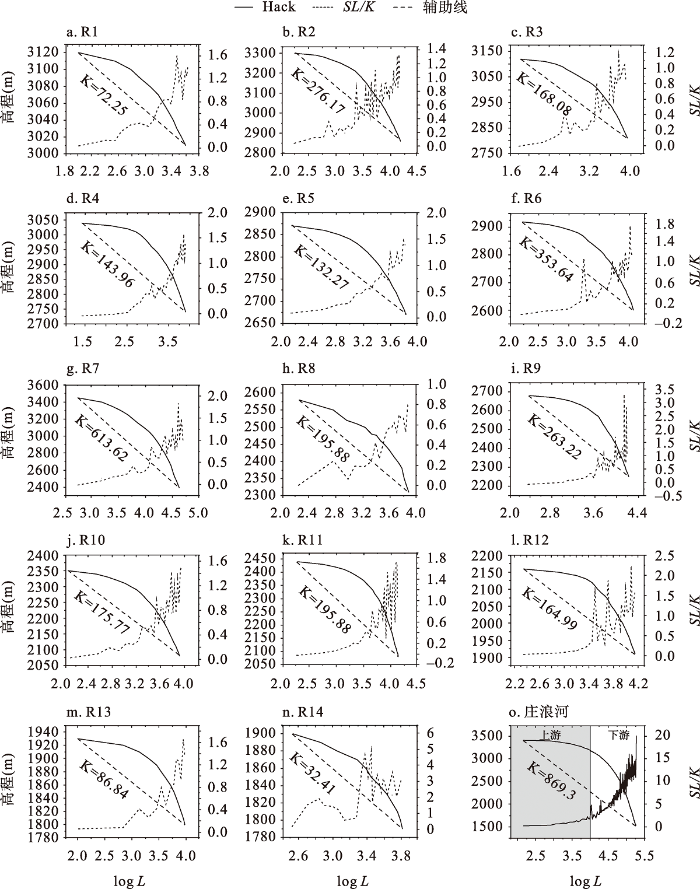
图6
干流西侧支流及干流的标准河流坡降SL/K和Hack剖面
Fig. 6
SL/K and Hack profiles of standard river slopes on the west side of the main stream
图7
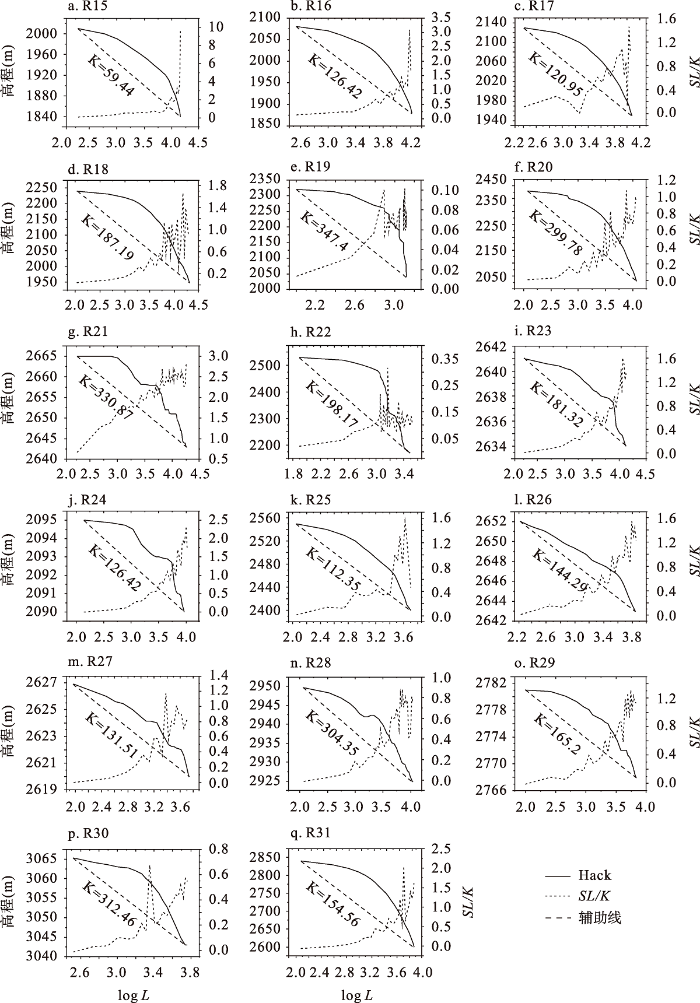
图7
干流东侧标准河流坡降SL/K和Hack剖面
Fig. 7
SL/K and Hack profiles of standard river slopes east of main stream
4.2 面积-高程积分值(HI)与积分曲线(HC)的空间分布特征
图8
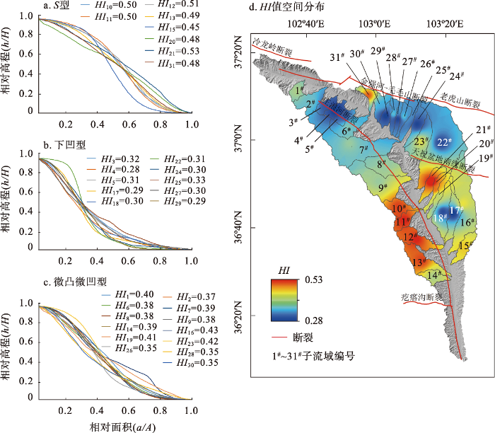
图8
31个子流域HC曲线及HI值空间分布
Fig. 8
HC curves and spatial interpolation distribution of HI values in 31 sub-basins
干流东侧17个子流域的HI值介于0.29~0.53,7个处于老年期(17#,18#,22#,24#,25#,27#,29#),HC曲线呈下凹形态,其他整体处于从壮年期、壮年老期向老年壮期的过渡阶段,对应HC曲线呈微凹形态。
综合来看,庄浪河31个子流域,HI>0.35的子流域占流域总面积的59%,反映整个流域的地貌演化仍处于壮年期,但对比流域东西两侧,西侧侵蚀能力强于东侧,西侧流域的构造活动性更强。
5 讨论
5.1 河流坡降指标(K、SL、SL/K)与Hack剖面所指示的构造意义
庄浪河流经金强河盆地、天祝盆地和永登盆地,各区的岩性、水系发育特征和地表过程均存在较大的差异。其中最大K值(K=613.62)位于庄浪河最大支流石门河流域(盆地编号7#)内,7#流域内出露大面积中奥陶统层状灰岩和千枚岩(见图5d)。灰岩遇水易被溶融,千枚岩风化严重,岩石抗侵蚀能力差。庄浪河断裂大致由石门河经过,其逆冲推覆、右旋走滑的运动方式[39],使得该处奥陶系灰岩、千枚岩破碎,岩石抗侵蚀能力进一步下降。通过野外调查发现庄浪河断裂在天祝境内华藏寺马家湾台山前经过,奥陶系灰岩、千枚岩逆冲在新近系地层之上,形成强烈的挤压破碎带,带宽2~3 m,反映断层曾有过新的活动(见图9)。据此推断,断裂活动和岩性的双重因素导致该处出现异常高的K值。对比干流东西两侧河流的Hack剖面,西侧河流总体呈上凸形态,局部河段的SL/K值变化较大,其中R9、R12、R14三条河流(见图6)局部河段SL/K>2,属于较陡河段,其余支流的SL/K<2,反映了河流坡降较小,河道平滑。干流东侧部分河道的Hack剖面出现不同程度的下凹,庄浪河下游西岸主要发育砂岩、砾岩和第四系冲洪积物,各类型岩层抗侵蚀能力不一致且出露不连续,造成流域内侵蚀程度差异化,因此SL/K值会出现高低起伏的特征,干流流经马雅雪山-宝泉山构造带处Hack剖面明显变陡,构造带内河流落差变化较大,对应的SL/K值也出现明显的起伏(见图6)。根据Brookfield[24]的解释,河流在向均衡剖面演化过程中,受断层活动影响,其纵剖面会发生调整以适应构造活动的强度。由图6看出干流西侧支流在接近出口位置时SL/K值均出现大幅变化,庄浪河断裂沿干流西侧山前由北向南延伸,因此干流西侧河流在接近出口时SL/K值出现峰值,极有可能受庄浪河断裂的影响,局部河道落差变大,导致SL/K值增大。通过以上分析认为,庄浪河流域西侧的河道形态主要受构造活动影响,正处于过渡至新均衡剖面的初期阶段,流域东侧河道形态更加接近均衡剖面。
图9
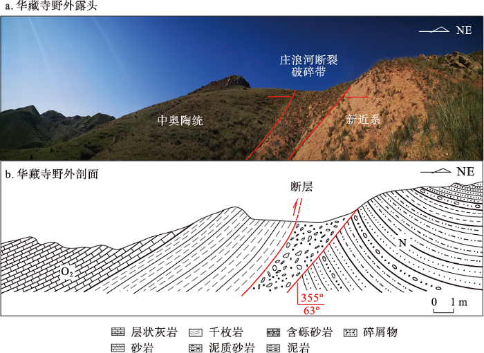
图9
华藏寺马家台野外露头及野外剖面
Fig. 9
Majiatai outcrop of Huazang Temple and field profile.
通常河流下游的K值和SL值理应大于上游,即两值与径流量或汇水面积有关,而庄浪河流域的出现截然相反分布格局。张福祥[14,15]对比庄浪河上、下游地区的水系格局和地层分布特征认为,永登盆地和天祝盆地并非直接贯通,中更新世末青藏高原经受自隆起以来最强烈的地壳运动[44],兰州地区黄河河面降低[45],庄浪河溯源侵蚀加快,最终切穿马雅雪山-宝泉山构造带,袭夺了古金强河。何文贵等[46]采用TL样品确定了天祝盆地内Ⅱ级阶地的形成时代为79±1.1 ka B.P.;刘小凤等[20]、刘兴旺等[21]利用光释光测年手段,得到庄浪河下游Ⅰ、Ⅱ级阶地形成时间分别为60 ka B.P.和52.6±4.6 ka B.P.;可以看出庄浪河上、下游Ⅱ级阶地的形成年龄相差至少20 ka,同级阶地年龄相差甚大。地貌形态上,庄浪河上游河段支流发育,河谷宽阔,而下游河段支流多为短小的时令河或黄土冲沟,河谷宽狭窄,这也进一步证实了古金强河被庄浪河袭夺的观点,也可解释上游地区K值和SL值整体高于下游地区的这种分布特征。
5.2 面积高程积分值(HI)和积分曲线(HC)所指示的构造意义
面积-高程积分的物理含义是流域在内动力和外动力作用下的体积残存率[25],通常,面积-高程积分值(HI)受岩性和构造因素的双重影响。庄浪河中下游西岸地区的HI值明显偏高(见图8d),该地区主要出露白垩系砂质泥岩、古近系砂砾岩、新近系含砾砂岩和第四系风积黄土(见图5d和图10),这些地层物质组分抗侵蚀能力弱,地表侵蚀严重,显然这与低地表残存率地区具有低HI值的结论相矛盾;庄浪河东岸宝泉山南坡地带与庄浪河下游西侧的HI值有很高的相似性,而宝泉山南坡主要出露奥陶系玄武岩、灰岩和变砂岩,志留系砂岩和板岩,与庄浪河中下游西侧地区的岩性相差较大(见图5d)。因此,本研究认为不同的岩性展布并非该地区地貌演化的主导因素。同时,通过观察发现该地区的HI值空间展布特征与断裂延伸具有较好的吻合性。郑光佑[47]在研究台湾中央山脉两侧的断层时发现,断层上盘附近的HI值通常高于其下盘,庄浪河地区受到NE向的挤压应力,造成庄浪河断裂上盘发生逆冲推覆作用,且这种挤压应力已传递到庄浪河东岸地区,其东岸阶地发生的挠曲变形是最为直观的证据[48]。据此认为,庄浪河断裂的逆冲右旋走滑活动极有可能造成庄浪河中下游西岸地区本应偏低的HI值明显偏高,这也进一步反映该地区构造运动更为活跃,也体现了断裂活动的空间差异性,这一结果与周德敏等[16]关于庄浪河断裂带滑动速率的研究结论基本一致(河口-龙泉段(0.6±1.5)mm/a,龙泉-永登以北段(0.15±1.5)mm/a)。
图10
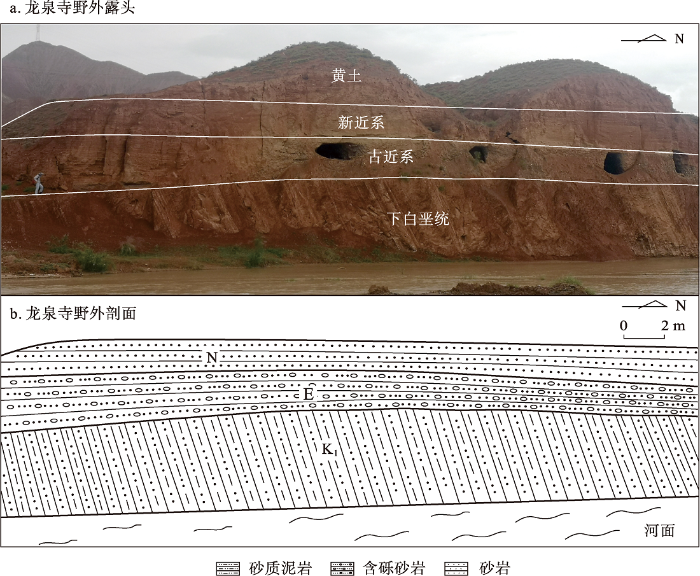
图10
庄浪河下游西岸龙泉寺附近野外露头及野外剖面
Fig. 10
Wild outcrop near Longquan Temple on the west bank of the lower reaches of Zhuanglang River and field profile.
6 结论
本研究采用ALOS DEM 12.5 m数据,基于ArcGIS空间分析技术,通过高程条带剖面、河流坡降指标体系(K,SL,SL/K)和Hack剖面、面积-高程积分值(HI)和积分曲线(HC)等方法,结合野外地质调查,探讨流域地貌发育特征,分析其对新构造的指示意义,定量化研究庄浪河流域的构造活动和地貌演化,得到以下初步结论:
(1)庄浪河子流域的面积-高程积分值HI和积分曲线HC形态、河长坡降指标(K、SL、SL/K)和Hack剖面形态结果显示,流域西侧地貌参数均高于流域东侧,表明庄浪河流域西侧构造活动比流域东侧强,造成这种东西差异的主要原因是庄浪河断裂两侧构造活动强度的不对称性。
(2)庄浪河西侧流域的地貌发育正处于过渡至新均衡剖面的初期阶段,东侧流域受构造活动影响较弱;西侧流域的HI值整体高于东侧,西侧流域的积分曲线(HC)多呈S型或上凸形态,而东侧流域的HC曲线多呈下凹状,表明庄浪河流域西侧的构造活动性相比东侧强,地貌演化受侵蚀下切和构造活动的双重影响。
(3)庄浪河断裂晚新生代以来仍存在构造活动,其逆冲走滑的运动方式控制着庄浪河地区的水系发育格局,整个庄浪河流域的地貌演化正处在壮年期。
致谢
真诚感谢两位匿名审稿专家在论文评审中所付出的时间和精力,专家对定量地貌研究方法的运用和地貌证据分析方面的建议对文章质量提升有很大帮助。
参考文献
The growth of northeastern Tibet and its relevance to large-scale continental geodynamics: A review of recent studies
Seismic structure beneath the Tibetan Plateau from iterative finite-frequency tomography based on ChinArray: New insights into the Indo-Asian collision
In situ low-relief landscape formation as a result of river network disruption
Spatial and temporal pattern of erosion in the Three Rivers Region, southeastern Tibet
Cenozoic tectonic evolution of Qaidam basin and its surrounding regions (Part 1): The Southern Qilian Shan-Nan Shan thrust belt and Northern Qaidam Basin
Danghe area (western Gansu, China) biostratigraphy and implications for depositional history and tectonics of northern Tibetan Plateau
祁连山北缘老君庙背斜晚新生代磁性地层与高原北部隆升
Late cenozoic magnetic stratigraphy of Laojunmiao anticline in the northern margin of Qilian Mountains and uplift of the northern Plateau
Magnetostratigraphy of the Neogene Chaka basin and its implications for mountain building processes in the north-eastern Tibetan Plateau
Erosion, fault initiation and topographic growth of the North Qilian Shan (northern Tibetan Plateau)
祁连山东段石羊河流域河流纵剖面及其构造意义
Longitudinal profiles and their tectonic significance of the Shiyanghe River Basin in the eastern Qilianshan Mountains
构造地貌学: 构造-气候-地表过程相互作用的交叉研究
Tectonic geomorphology: An interdisciplinary study of the interaction among tectonic climatic and surface processes
新构造运动对冲积河流影响研究的回顾与展望
DOI:10.11821/dlyj201503004
[本文引用: 1]

研究新构造运动本身及其对冲积河流的影响,可以深化地貌学理论、沉积旋回复杂性假设等的认识,也与实际应用密切相关。将活动构造作为新构造运动的一个组成部分,回顾了新构造运动对冲积河流影响,并提及新构造运动本身的研究进展。控制流域水系格局及河流走向的研究,侧重地质学解释;新构造运动应力场的研究,深化了新构造运动机理及驱动力的探讨。三类基本缓慢新构造运动影响水系发育、河床演变、河型变化及河道冲淤,表现出复杂性、层次性、敏感性和先兆性;文章兼及河流侵蚀作用形成“新构造”的研究进展,回顾了物理模型实验研究成就及数学模拟研究端倪。进而指出:应注重该学科的交叉、渗透、综合研究与新构造快速运动方式对冲积河流影响的研究,定期进行新构造运动活跃区的升降速率、河床演变与泥沙输移的观测,进一步推进物理模型实验与数学模拟研究,并加强研究力量的协作与融合。
A research of influence of neo-tectonic movement on alluvial rivers: Review and prospect
The study of neo-tectonic movement and its impact on alluvial river can deepen the understanding of the complex response theory in a geomorphic system and the complex hypothesis of multi-cycle deposition, and investigate thoroughly the relationship between sedimentary sequence and basin depositing processes, which can be widely applied to earth science, water engineering, traffic transportation, communications, oil and gas exploration and development, etc. In this paper, it is mainly reviewed the research progress of the influence of neo-tectonic movement in alluvial rivers, and neo-tectonic movement is described very briefly. In the embryonic period of the neo-tectonic movement, the study of the drainage pattern in a basin and the river towards controlled by the neo-tectonic movement, had been increasingly popular as a new discipline, but mainly focused on the geologic interpretation. Since the 1970s, research on the neo-tectonic stress field can help us understand the neo-tectonic mechanism and dynamics. In author’s point of view, active tectonics can be taken as part of the neo-tectonic movement, and the type and ratio of neo-tectonic movement has significant effect on alluvial river morphology and channel evolution, including the plane form, channel width, longitudinal profile, cross section, sinuosity, braided index, cutting strength and range, channel pattern, transport type and amount of sediment, which shows the complexity, hierarchy, sensitivity and prophetic. Influenced by active fold, uplift and depression on river longitudinal profile development, the compensation of subsidence by the sedimentation is concerned specially. As for the influence of neo-tectonic movement on alluvial river plane shape, the sinuosity was taken as the barometer of alluvial river in response to neo-tectonic activity. As for the effect of active fault on river development and evolution, sensitivity and prophetic are especially mentioned. This paper deals with the research progress in the bedrock exposed on riverbed by active uplifting, which resulted in developing both pressed and release meandering along upstream and downstream, respectively, and the so called "New structure", formed by river erosion. The traditional research methods and techniques are not generally described but mentioned that the experiment simulation has obtained remarkable achievements at home and abroad, and the mathematical simulation is just unfolding. It is prospected that at first, to pay attention to the crossing, permeating and comprehensive research of neo-tectonic movement impacting to alluvial river, the second to focus on effects of rapid tectonic movement to alluvial river, the third to observe regularly lifting rate of neo-tectonic movement, the riverbed evolution and sediment transportation in the neo-tectonic active area, the fourth, to take caution more with the physical model experiment and mathematic simulation, in which there is a great space for development, and finely to strengthen the cooperation and fusion of research ability. The study will enter a new stage of development.
兰州庄浪河断裂带的新构造变形与地震活动
The neotectonic deformation and earthquake activity in Zhuanglang River active fault zone in Lanzhou
祁连山庄浪河地貌发育的若干特征
Some geomorphic characteristics of the Zhuanglang River in the region of Qilian Mountains
根据古浪幅及邻区卫星影像讨论祁连山庄浪河的河流袭夺问题
A discussion on river capture of the Zhuanglamg River system in the Qilian Mountain by landset images of the Gulang and neighbouring region
武威-天祝-庄浪河NNW向断裂分段及变形特征
Segmentation and deformation characteristics of Wuwei Tianzhu Zhuanglanghe Fault Zone
基于GPS观测资料反演庄浪河断裂带、马衔山北缘断裂带的滑动速率
Inversion of slip rate of the Zhuanglang faults and the northern marginal of Maxianshan based on GPS measuremants
马衔山北缘断裂带及庄浪河断裂带的地震危险性分析
Seismic risk analyze on the northern marginal fault of Maxianshan and Zhuanglanghe faults
兰州及邻近地区河流阶地变形特征
Study on the deformation characteristics of river terraces in Lanzhou and adjacent region
兰州庄浪河阶地差分GPS测量与构造变形分析
Anaiysis of tectonic deformation on Zhuanglang River terrace in Lanzhou based on the differential GPS surveying
Tectonic geomorphology of escarpments: The cases of Kompotades and Nea Anchialos faults
Stream-profile analysis and stream-gradient index
The evolution of the great river systems of southern Asia during the Cenozoic India-Asia collision: Rivers draining southwards
DOI:10.1016/S0169-555X(97)00082-2 URL [本文引用: 3]
Along-strike variations of morphotectonic features in the Western Foothills of Taiwan: Tectonic implications based on stream-gradient and hypsometric analysis
岷江水系流域地貌特征及其构造指示意义
Geomorphology of the Minjiang drainage system (Sichuan China) and its structural mplication
庄浪河流域各乡镇降水蒸发情况分析研究
Analysis and research on precipitation evaporation of villages and towns in Zhuanglang River Drainage Basin
甘肃省庄浪河流域水资源可持续利用对策研究
Countermeasure research on sustainable utilization of water resources in Zhuanglanghe River Basin in Gansu
甘肃省天祝县降水量时空特征分析
Spatial-temporal characteristics of precipitation in Tianzhu County, Gansu Province
ALOS-PRISM立体像对提取DEM的应用研究
Study on DEM extraction by ALOS-PRISM stereo pair
On the longitudinal profile of the graded river
东昆仑山昆仑河纵剖面形貌分析及构造涵义
The analysis of the tectonics and the longitudinal section of Kunlun River in East Kunlun
北天山流域河长坡降指标与Hack剖面的新构造意义
Implication of active structure along the Northern Tianshan by stream Length-Gradient Index and Hack Profile
龙门山中段山前河流Hack剖面和面积-高程积分的构造地貌研究
Tectonic geomorphology analysis of piedmont rivers of the Midddle MT. Longmenshan based on Hack Profile and Hypsometric Integral
Hypsometric (area-altitude curve) analysis of erosional topography
Elevation-relief ratio, hypsometric integral, and geomorphic area-altitude analysis
祁连山西段疏勒河流域地貌特征及其构造意义
Geomorphic feartures of the Shule River Drainage Basin in Qilianshan and insight into tectonic implicaions
基于Strahler面积-高程分析的云南石林县域喀斯特地貌演化的量化研究
DOI:10.11821/dlxb201805015
[本文引用: 1]
基于异质性喀斯特地貌结构与喀斯特保护地整体保护利用的关系,将水平蚀低垂直加深的喀斯特地貌发育机制落实于地理信息系统支持的Strahler面积—高程分析,形成整体、海拔段和内部洼地的面积—高程曲线与积分值指标组,以量化石林县域喀斯特地貌演化。结果表明不同地貌发育特征的不同地形面具有不同的Strahler值,其差异和规律性有一定的指示价值。石林县四级海拔梯级地貌处于壮年晚期,为断裂切割与巴江侵蚀基准面差异性控制下的孤丘夷平面分解,属同期异构的回春型地貌区。> 2100 m海拔段为孤丘夷平构造侵蚀溶原中山,洼地不发育。1900~2100 m海拔段为孤丘夷平面转向孤丘溶原洼地、峰丛洼地,暗河不发育。1700~1900 m海拔段为溶丘洼地斜坡,由蚀余状石林—剑状石林—覆盖石林—烘烤石林组成的石林垂直层状结构与溶丘—洼地—暗河—泉群—河谷盆地组成的水平梯级地貌结构,它是水平与垂直地貌过程的融合产物。石林发育区既为水源形成区,也为水土流失区。这是石林保护地整体保护利用的地貌动力依据。
A quantitative study on the karst geomorphic evolution of Shilin County in Yunnan Province of China based on Strahler hypsometric analysis
Based on the relationship between the heterogeneous karst geomorphic structure and the integral protection and utilization of the karst reserve, Strahler hypsometric (area-altitude) analysis is used to quantify the karst geomorphic evolution of Shilin county in Yunnan province of China. The Strahler hypsometric values of the whole area (catchment), elevation zones' terrains and their depressions are measured. Supported by Geographical Information System (GIS) technologies, these Strahler hypsometric measurements are designed based on the development mechanism of karst landform, which includes height-reduction horizontal erosions and depth-increase vertical erosions. The results indicate that landscapes with different development features on various topographic surfaces have different Strahler values. The differences and patterns could be used as an indicator to reflect the evolution of landscapes. Shilin county's geomorphic structure has four levels of terrains with different altitudes at the late period of mature stage. Such a structure is formed from the decomposition of the monadnock karst planation plateau with an interplay of the faults and the erosion base of Bajiang river. Shilin county has a rejuvenating geomorphic structure, which is heterogeneous from other geomorphic structures of the same stage. The terrain above 2100 metres of altitude is the structural erosion karst plateau middle mountain evolved from the monadnock karst planation plateau with less depressions. The terrain with an altitude of 1900-2100 metres shifts from the monadnock karst planation into the monadnock karst plateau depressions and cone karst depressions with less underground rivers. The elevation zone with an altitude of 1700-1900 metres is a karst hill slope. The zone is composed of the vertical layer structure of the Stone Forest and the horizontal terrace geomorphic structure. The vertical layer structure of the Stone Forest comprises stone forest remains, pinnacle-shaped stone forest, buried stone forest, and baked stone forest. The horizontal terrace geomorphic structure contains karst hills, stone forest, karst depressions, underground rivers, karst springs, and Bajiang river-basin. The landform is shaped from the mixed functions of vertical and horizontal karst processes, with water resources produced and water-soil eroded off. This is the theoretical foundation for the comprehensive protection and utilization of the Stone Forest reserve.
地貌形态指标揭示的北天山乌鲁木齐河流域新构造活动特征
Neotectonic activation of the Urumqi River Basin revealed by geomorphic Indices
利用面积高程积分方法研究龙门山断裂带地貌隆升特征
Study on the geomorphic uplift characteristics of the Longmenshan Fault Zone using Hypsometric Integral Method
均值变点分析法在最佳集水面积阈值确定中的应用
Determination of accumulation area used on the method of applying mean of change-point analysis
新生代晚期青藏高原强烈隆起及其对周边环境的影响
Late cenozoic intensive uplift of Qinghai-Xizang Plateau and its impacts on environments in surrounding area
晚新生代黄河上游地貌演化与青藏高原隆起
Geomorphic evolution of the upper yellow river and uplift of the Tibet plateau in the late cenozoic
天祝盆地边缘断层的全新世活动及盆地的演化与形成
Holocene activity of faults around the Tianzhu Basin and evolutionary process of the basin
兰州地区活动构造格架与变形特征
Active tectonic framework and deformation features in Lanzhou Area
