

1 引言
20世纪以来随着全球气候变暖和海平面上升[1],世界诸多海岸尤其是河口三角洲地区,如长江三角洲、珠江三角洲、恒河三角洲、密西西比河三角洲和莱茵河三角洲等都遭受过风暴潮极端复合洪涝灾害袭击[2⇓⇓-5]。而处于中低纬度的河口三角洲大多是人口密集的富庶之地,但往往经济欠发达,防护能力不足,例如湄公河三角洲、伊洛瓦底三角洲、恒河三角洲以及位于印度、菲律宾和印度尼西亚等国家的河口三角洲地区主要依靠土质堤防来抵御日益增强的热带风暴潮洪水[6,7]。然而,潮间带湿地自然消浪、防御风暴潮的功能被忽略了[8]。自20世纪中叶以来,许多发展中国家为缓解人口膨胀和用地紧张不断向海扩张、围垦潮滩[7,9]。导致滩涂湿地不断消亡,置新围低地暴露于深水环境和高强度风浪威胁之下[10]1-3,例如孟加拉国潮间带筑坝导致沿海洪涝灾害进一步放大[11]。未来随着经济发展,河口三角洲暴露度成倍增长,沿海低地对风暴潮越浪、溃堤引发洪水灾害的放大效应高度敏感[12]。
为防御沿海风暴潮灾害,中国在进行滩涂围垦的同时也修筑了长达1.4万km的海堤工程,保护约6亿沿海人口的生命财产安全[13]2。历史经验证明硬质海堤对缓解风暴潮洪水的经济损失和人员伤亡具有高度可靠性,但未来随着海堤老化、海平面上升、海岸地基沉降和不断加剧的极端风暴潮等级诱发的致灾因子和承灾体变化,传统堤防设施的防护能力将面临严峻挑战[6]。同时,硬质海堤的维护成本随着时间推移急剧上升[13]5-6。相反,具有动态更新能力的潮滩湿地生态系统被认为是“躺卧式大堤”,可与传统硬质海堤——“站立式大堤”相辅相成,提供基于自然的保护方案[14]10-11。而且,潮滩湿地具有消浪[15]、促淤[16]2和抵御海平面上升的自然恢复力[17]。因此与常规“硬”质海堤相比,生态“软”措施不需要结构性维护,并能提供“硬”质海堤不具备的生态系统综合服务价值[18]278-279。因此,在海陆交界面上修复潮滩和种植盐沼植被,形成基于自然的防洪综合体具有广阔应用前景。
滨海湿地基于潮滩地形的浅水破波作用[19]255-256和盐沼植被的物理拖拽作用[20]削减近岸波浪能量。盐沼植被的削浪作用既取决于植株单体的物理特征,如株高、直径和茎干韧性[21],也取决于植被生态系统特性,如盐沼宽度、植株密度和地上生物量特征[14]2-7。即使滨海湿地植被在冬季消亡或茎杆断裂,潮滩淤高的地形仍具有重要的削浪能力,如地形斜坡削浪作用[22,23]、底摩擦削浪作用[8]3和浅水破波作用[19]255-256。为测试潮滩植被“躺卧式大堤”与硬质海堤“站立式大堤”组合而成的复合型防洪综合体,尤其是检验设防能力在大范围内的空间变化,需要借助大尺度数值模拟的方法将潮滩宽度与海堤高度转化为设计新型防洪综合体的知识要素[23]。本文研究目的为检验潮滩因围垦损失后造成近岸波浪增高、未来极端风暴潮水位增加及堤防老化沉降综合作用下实际越浪量的变化。采用情景模拟法能够对多重现期极端风暴潮影响下潮滩围垦对越浪加剧的影响及其修复措施进行有效性评估。
本文以上海杭州湾北岸为研究区,探讨潮滩围垦、越浪加剧及未来适应性生态修复措施的有效性。杭州湾北岸是上海最重要的工业、教育、港口中心。2020年9月开辟的中国(上海)自由贸易试验区临港新片区占据了杭州湾北岸大部分岸线。历史上这里曾多次发生严重的风暴潮灾害,例如9711号“温妮”台风风暴潮期间杭州湾北岸溃堤、漫堤岸段达几十处,遭受了严重的海岸洪水,直接经济损失达400亿人民币[24]。本研究根据遥感解译的近35年岸线变化、滩涂围垦和盐沼湿地分布,利用水动力数值模拟法确定历史时期极端风暴潮风险变化,并结合2019年实测的海堤高度、未来海平面上升和坝体沉降可能性,评估未来2050年和2100年杭州湾北岸越浪变化。随后,采用潮滩生态修复的方法对高风险岸段重新规划和修复潮滩之后再次运行水动力模型,确定复合型防洪综合体达标需要的最小潮滩宽度、上覆植被特征及海堤高度。本研究对高强度人类围垦岸线风险评估、受损岸线修复和海岸带可持续发展规划具有一定参考价值。
2 研究区概况
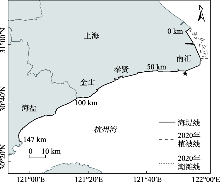
杭州湾北岸上海段位于长江三角洲南翼、钱塘江河口以东,主要包含南汇、奉贤、金山3个区的滨海岸段(图1)。北至浦东机场、西至沪浙交界,岸线总长度106 km,约占上海市大陆岸线的60%。杭州湾北岸是一个以城市规划为主,集沿海城市、港口、工业、教育等多功能于一体的经济开发区。区内建设有中国(上海)自由贸易试验区临港新片区,对长三角乃至整个中国东南沿海发展起重要带动作用。但杭州湾潮滩总体呈现南淤北侵的现状[25],导致北岸长期遭受潮流冲刷作用,不断侵蚀沿岸滩涂,加之杭州湾北岸在近40年内进行了大量滩涂围垦活动,导致海岸线前移,潮滩宽度束窄,大大加剧了该地区的洪涝风险。上海周边海塘建设历史悠久,自20世纪50年代以来,修建了一系列现代化堤防设施提高防洪能力和近岸航行条件。但杭州湾北岸也遭受着越来越严重的越浪风险[26],海岸溃堤和漫堤时有发生[27],加剧了杭州湾北岸的洪水淹没[10]3。
图1
3 数据来源与研究方法
3.1 数据收集与预处理
杭州湾北岸历史潮滩地貌演变信息由Landsat TM系列卫星遥感影像提取(
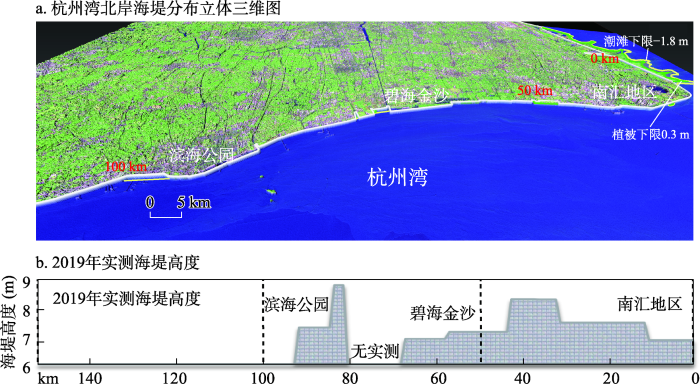
为解译海堤位置、光滩面积和潮滩植被分布,采用标准假彩色波段组合解译。首先采用目视解译法提取海堤线和水边线位置。然后通过解译的潮滩宽度联合历史潮位观测数据,计算平均潮滩坡度,并推算出大潮低潮位水边线位置。最终以1984年海堤线和潮滩宽度为基准,定量分析人工围垦和潮滩面积的历史变化过程。海岸堤防的堤顶高度数据由2019年8月实测获取(图2),其中某些岸段为禁入区域,无法获取实测高程,但根据企业建设防洪要求,认为该地符合上海规划的海堤防洪标准。
图2
3.2 潮滩地形DEM重建
潮间带滩涂处于海陆交接处,滩面泥泞且变动频繁,其地形数据是常规地形测量的空白区[10]3。同时,受潮位变化,潮间带常处于淹没、半淹没状态,普通单次航空摄影测量法也无法获得整个杭州湾北岸滩涂地形高程全貌。本文采用长时间序列、高频次卫星遥感获得的水边线法配合实测潮位数据反演潮间带地形高程[16]3-4。随后采用遥感解译的盐沼植被分布对潮间带高程进行矫正。根据1984—2020年遥感影像目视解译的植被线及对长江口盐沼植被的实地观测和统计分析表明,特定种类的盐沼植被随地形高程呈带状分布,高、中、低盐沼植被生长高程的下限分别对应着高(1.3~1.8 m)、中(0.8~1.3 m)和低(0.3~0.8 m)潮滩下限[10]3-4,因此本实验结果表明潮滩高度在0.3 m以上为植被区,而−1.8~0.3 m为裸露的光滩。根据长江口潮情的特点,潮滩水边线下限设置在大潮低潮位-1.8 m处。利用提取的水边线、海堤线和潮滩植被带分别赋予相应高程值,采用ArcGIS 10.2自然临近法对提取的等高线进行插值,制作10 m分辨率潮滩DEM,最终生成1984—2020年7个主要年份的杭州湾北岸潮滩地形DEM数据,并镶嵌到2009年长江口实测海图地形数据制作的DEM上,形成大范围杭州湾-长江口水下地形DEM数据。
3.3 近岸水动力数值模拟
3.3.1 波浪模型原理与设置
模拟基于MIKE 21 Spectral Waves FM(简称MIKE 21 SW),是新一代非结构网格频谱波浪模型,适用于近海和沿岸的风浪生成、传播和衰减模拟。模型采用不规则三角网划分,格网分辨率从外海的5 km到近岸的50 m渐变(图3)。网格上每个结点被赋予潮滩地形高程,制作7个历史年份的地形网格。网格分为内外两个边界,内边界设置在杭州湾北岸沿岸海堤线上,外边界设置在远离海岸线的外海处,指定4个重要波浪参数,包括有效波高、峰值波周期、平均波向和方向扩散指数。
图3
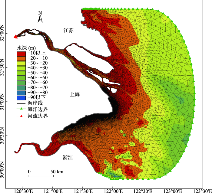
图3
研究区网格划分与水深分布
Fig. 3
Irregular triangular mesh and water depth distribution in the North Hangzhou Bay
MIKE 21 SW波浪模型以波作用守恒方程为基础,利用波作用密度谱N(σ,θ)来表述波浪,相对波频率σ和波向θ为自变量:
在笛卡尔坐标系中,MIKE 21 SW的波作用守恒方程:
式中:N(x,σ,θ,t)为波作用密度;x=(x,y)为笛卡尔坐标分量;V=(cx,cy,cσ,cθ)表示波群在x、y、σ、θ的传播速度;cx和cy分别表示波作用在地理空间(x,y)中传播变化;cσ表示由水流和水深变化引起的相对频率变化;cθ表示因水流和水深导致的折射;S指能量平衡方程中由频谱密度表示的源函数:
式中:Sin风输入能量;Snl波浪之间的非线性相互作用产生的能量耗散;Sds白帽引起的能量耗散;Sbot底摩擦引起的能量耗散;Ssurf水深变化引起的破浪能量耗散[30]。
3.3.2 模型律定与验证
表1 “凤凰”过境时刻实测波浪与模型结果对比
Tab. 1
| 时间段 | 时间 | 仪器高度(m) | 仪器测量高程(m) | 平均有效波高(m) | 总高度(m) | 模拟结果高度(m) | RMSE |
|---|---|---|---|---|---|---|---|
| T1 | 20日21:00 | 0.45 | 1.05 | 0.26 | 1.76 | 1.798 | 0.019 |
| T2 | 21日10:00 | 0.32 | 1.82 | 1.805 | 0.007 | ||
| T3 | - | - | - | - | - | ||
| T4 | 22日11:00 | 0.58 | 2.08 | 1.997 | 0.042 | ||
| T5 | 22日23:00 | 0.6 | 2.10 | 2.010 | 0.045 | ||
| T6 | 23日11:30 | 0.8 | 2.30 | 2.248 | 0.026 | ||
| T7 | 23日23:30 | 0.46 | 1.96 | 1.985 | 0.012 | ||
| T8 | 24日12:00 | 0.23 | 1.73 | 1.787 | 0.028 | ||
| T9 | 25日00:00 | 0.14 | 1.64 | 1.687 | 0.023 |
图4
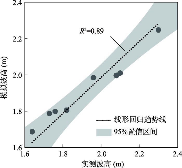
图4
2014年台风“凤凰”过境时刻9个淹水时段波浪高度测量值与模拟值对比
Fig. 4
Comparison of measured and simulated wave height in nine inundation time periods during 2014 Typhoon “Fung-wong”
经律定,采用的模拟时间步长设置为10 s,波谱频率离散类型设置为等距、频数为30,最小频率为0.055 Hz,频率间隔为0.03 Hz。海底糙率设置为0.002 m,潮滩植被覆盖区的芦苇糙率值设置为0.12 m,海三棱瀌草糙率设置为0.014 m,无植被的光滩糙率设置为0.002 m。实测检验为模型模拟提供了良好的参数律定和模型验证,可用于模拟多重现期下杭州湾北岸近海波浪生成、传播和衰减变化。
3.4 未来情景海堤失效评估方法
根据IPCC第五次评估报告,在过去十年中全球平均海平面以4 mm/a的速度上升[32]。按该趋势估算到2050年海平面上升约0.12 m,到2100年海平面上升约0.32 m。上海地区1980—2005年平均地面沉降率约为0.51 cm/a[33]28。估算到2050年海堤沉降约为0.15 m,到2100年海堤沉降约为0.41 m。结合未来台风风暴潮增强趋势推算出杭州湾北岸每隔50年有效波高将增大0.25 m,台风增水增长0.1 m[10]14。因此,未来海堤失效评估方法为未来多重现期下模拟的水位和有效波高与未来预测的海堤高度比较,计算未来可能的越浪高度作为上海杭州湾北岸海堤防洪失效的判据,越浪计算公式为:
式中:Δ为越浪高度;Hc为潮位高度;Hz为风暴潮增水高度;Hb为波浪高度;Hd为预测的海堤高度。如果Δ大于0说明该区段存在越浪,反之则无。
4 结果分析
4.1 围垦引起的滩涂和植被面积变化
1984—2020年,杭州湾北岸进行了多期的潮滩围垦,围垦总面积达301.7 km2,海岸线从150 km增加到185 km,其中以1997—2015年浦东机场建设和1996年至今的临港新城建设影响最大(图5)。历史围垦阶段可划分为4个典型时期。早期(1984—1994年)围垦量较少,仅占总围垦面积的11.6%。其中,浦东机场-南汇东滩围垦面积约为13.1 km²;南汇东滩和奉贤海岸的围垦面积约为16.2 km2;金山地区的围垦面积约为4.8 km²;其余地区仅存在小规模围垦,面积约为1~2.5 km²。中期(1994—2003年)进行了大规模围垦,占总围垦面积的46.4%。其中,浦东机场-南汇东滩围垦面积达122.4 km²;南汇南滩围垦面积约4.9 km²;奉贤海岸围垦面积约为10.4 km²;其余地区存在小规模围垦,面积约为0.5~1.5 km²。后期(2003—2013年)进行了大规模围垦,占总围垦面积的34.8%。其中,浦东机场-南汇东滩围垦面积为65.3 km²;南汇南滩围垦面积约为3.8 km²;其他地区围垦面积约为9~14.3 km²。近期(2013—2020年)围垦基本停止,围垦量仅占总围垦面积的7.2%。仅在浦东机场-南汇东滩地区围垦面积稍大,约为15.6 km2;在南汇南滩和金山地区分别围垦1.7 km²和4.5 km²,其他地区未见明显围垦。
图5
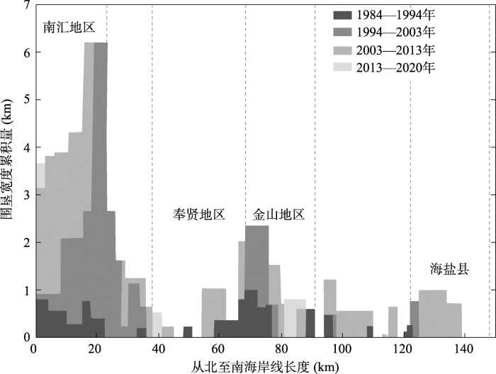
图5
1984—2020年杭州湾北岸海堤线累积围垦宽度
Fig. 5
Cumulative tidal flat reclamation width from 1984 to 2020 along North Hangzhou Bay
在人类围垦和自然淤涨/侵蚀双重胁迫作用下,潮滩面积发生持续变化(图6)。1984—2020年潮滩面积累积量分析表明,随着潮滩围垦,杭州湾北岸潮滩总体面积逐渐减少,但呈现3个快速淤涨带,分别是南汇东滩、奉贤海岸和海盐县地区(图6)。1984—2000年南汇东滩潮滩平均淤涨量基本维持在2 km/a左右,随后逐渐下降,到2003—2013年因大量潮滩围垦工程,导致潮滩完全消失,但到2020年又逐渐恢复,最终35年间潮滩累积淤涨宽度达25 km。奉贤和海盐县的潮滩淤涨速度小于南汇东滩,35年间累积淤涨宽度约为6 km。其中,奉贤地区潮滩淤涨速率明显下降,从1984年的1 km/a下降至2020年的0.3 km/a;海盐县1984—2000年潮滩淤涨速度为1.3 km/a,之后持续下降,到2020年淤涨速度减少至0.5 km/a。其他地区随着海堤围垦,潮滩淤涨不明显,潮滩宽度逐渐减少。
图6
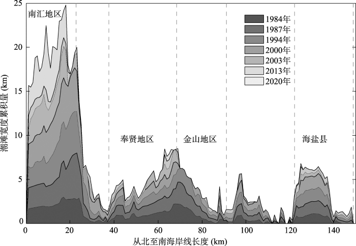
图6
1984—2020年杭州湾北岸潮滩宽度累积变化量
Fig. 6
Cumulative tidal flat width change from 1984 to 2020 along North Hangzhou Bay
围垦下潮滩植被面积发生连续变化(表2)。1984—1994年间杭州湾北岸潮滩植被总面积不断增加,随着南汇东滩和海盐县潮滩自然淤涨,植被也随之自然生长;1994—2013年间随着潮滩围垦活动加剧,植被总面积明显下降,基本维持在40~50 km²;但到2020年植被总面积急剧增加,随着南汇东滩大规模丁坝促淤,潮滩面积增大从而植被面积也迅速扩大。表2植被占比变化分析表明植被面积上升伴随着占比量迅速增加,说明植被通过侵占光滩面积增加其覆盖率。例如1987—1994年植被面积从原来的20.46 km²上升到44.59 km²,增加约24 km²,植被占比迅速增加了约10%。1994—2013年潮滩总面积减小,在2000—2003年甚至出现光滩面积增加但植被面积减小的情况。2003—2013年由于大规模潮滩围垦导致植被大量清除,光滩面积变化不大但植被变化占比迅速上升到97.13%。2013—2020年由于南汇东岸促淤工程效果显著,加速潮滩淤积,光滩和植被面积都快速上升,植被占比也下降至88.51%。
表2 1984—2020年典型年份杭州湾北岸潮滩植被面积统计
Tab. 2
| 年份 | 光滩面积 (km2) | 植被面积 (km2) | 潮滩总面积 (km2) | 植被变化占比 (%) |
|---|---|---|---|---|
| 1984 | 0.11 | 19.35 | 19.46 | - |
| 1987 | 0.47 | 20.46 | 20.93 | 75.27 |
| 1994 | 4.69 | 44.59 | 49.28 | 85.13 |
| 2000 | 1.28 | 41.17 | 42.45 | 50.06 |
| 2003 | 2.79 | 37.62 | 40.41 | 173.85 |
| 2013 | 1.71 | 1.15 | 2.86 | 97.13 |
| 2020 | 8.21 | 51.26 | 59.47 | 88.51 |
4.2 历史时期极端波浪高度变化
数值模拟表明,近35年来,在人类围垦影响下杭州湾北岸历史极端波高显著增大(图7a),近岸平均有效波高增加了约42.8%(图7b)。整体上看,从1984—2020年有效波高上升了0.6 m,其中1984—1994年间有效波高略微降低了0.1 m,之后1994—2003年和2003—2020年间有效波高增长率分别为0.04 m/a和0.02 m/a(图7b)。局部范围内,在2000年以前浦东机场-南汇东滩有效波高维持在1 m左右,而在2003—2013年大规模围垦后有效波高显著增加至1.5 m以上。之后经丁坝、矮堰等人工促淤工程,潮滩不断淤涨,到2020年有效波高又恢复到1 m左右。其他岸段潮滩以侵蚀为主,有效波高虽在局部范围内产生起伏,但总体呈逐年上升态势。例如,金山滨海公园岸段潮滩不断侵蚀,1984年和2013年有效波高都显著上升1 m左右,奉贤碧海金沙岸段于2003年显著上升0.75~1 m。而且,这些岸段的有效波高上升后没有呈现回落趋势,表明侵蚀型海岸的近岸风浪在潮滩围垦后表现出持续恶化态势。
图7
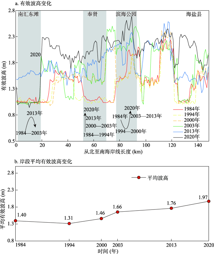
图7
杭州湾北岸200年一遇风暴潮影响下典型年份的有效波高变化和岸段平均有效波高变化
Fig. 7
Significant wave height change in typical years under the influence of 200-year return period storm surges for the variation along North Hangzhou Bay and the reach averaged significant wave height variation
4.3 未来杭州湾北岸越浪评估
为评估目前及未来堤防失效、发生越浪的程度,以2020年波浪高度与实测海堤高度比较,及预测未来2050年和2100年波浪高度和考虑堤坝沉降之后的越浪变化(图8)。2020年,杭州湾北岸在100~1000年重现期风暴潮影响下都未发生明显越浪现象,但在金山滨海公园附近虽未出现明显越浪,但极值水位高度已接近堤顶高度,相差仅0.2 m。因此,在该岸段存在一定程度越浪风险,需加强重视。2050年,在200年一遇风暴潮影响下水位逐渐抬升,平均抬升高度约为0.7 m,某些岸段出现越浪现象,例如金山滨海公园岸段极值水位高度已超过堤顶高度0.1 m左右。为防止越浪引起的大规模溃堤,重点岸段需加强海岸修复。2100年,在200年一遇风暴潮影响下水位明显抬升,平均抬升高度达1.7 m以上。此时大部分岸段出现明显越浪现象,总越浪堤坝长度达约20 km。其中,碧海金沙附近越浪高度接近0.5 m,而最高越浪岸段仍是金山滨海公园附近,极端水位超出堤顶高度达1 m以上,是越浪引发洪涝最严重的岸段。
图8
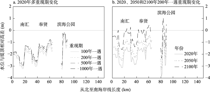
图8
杭州湾北岸上海段水位与堤顶相对高差
Fig. 8
The relative height difference between the water level and the seawall top along the Shanghai section of North Hangzhou Bay
4.4 潮滩防洪修复
越浪模拟分析表明,杭州湾北岸2050年越浪较严重的岸段为金山滨海公园附近(图9a)。为排除潜在灾害隐患,需要加强海堤建设,增高及加固原有堤防设施,或实施潮滩修复,扩宽、抬高滩面地形,通过增加地形底摩擦作用达到消减沿岸波浪高度的效果。基于2020年重构的杭州湾北岸潮滩地形和2050年预估的地面沉降高度,分别执行潮滩地形修复措施:① 修复金山滨海公园岸段潮间带滩面,平均拓宽0.7 km、抬高1.3 m,修复总长度13.5 km,总修复潮滩面积7.7 km2。潮滩修复后重新运行近岸风暴潮越浪模型,执行近岸风暴潮消浪效应评估。结果显示,修复后的波浪高度平均降低0.25 m(图9c和图9d中绿色线条所示),基本达到潮滩防洪修复目标;② 在潮滩地形修复基础上种植海三棱藨草等盐沼植被,增加滩面粗糙度,降低近岸有效波高。重新运行模型,结果显示修复后的波浪高度平均降低了0.35 m(图9c和图9d中红色线条所示),潮滩防洪修复效果显著提高。因此,通过潮滩地形修复和种植盐沼植被,可有效消减近岸波浪高度,使得金山滨海公园海岸的总水位下降到堤顶高度以下,说明生态潮滩修复措施可以替代海堤加高、加固措施,是未来高风险海岸堤防建设的有效补充方案。
图9
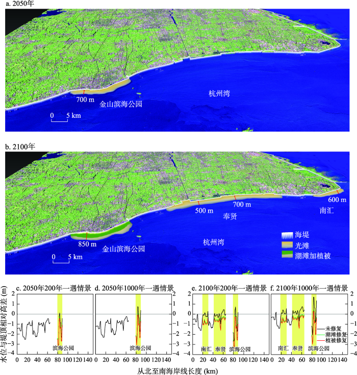
图9
杭州湾北岸2050和2100年潮滩修复与波浪高度测试
Fig. 9
Test of wave height along North Hangzhou Bay in 2050 and 2100 after tidal flat restoration
同样,越浪模拟分析表明,2100年杭州湾北岸近30%岸段都出现越浪(图9b),尤其在金山滨海公园岸段,最高越浪高度达1 m左右,存在较大洪涝灾害风险。为削减未来可能出现的极端洪涝灾害损失,需对杭州湾北岸整条岸段实施潮滩修复。基于2020年重构的杭州湾北岸潮滩地形和2100年预估的地面沉降高度,采用潮滩地形修复措施:① 整体修复杭州湾北岸潮间带滩面,平均拓宽500~1000 m,抬升1.3 m,修复总长度约100 km,总修复面积为75.4 km2。潮滩修复后重新运行近岸风暴潮越浪模型,执行近岸风暴潮消浪效果评估,结果显示修复后的波浪高度平均降低0.58 m(图9e和图9f中绿色线条所示),基本达到潮滩防洪修复目标;② 在潮滩地形修复基础上种植海三棱藨草等盐沼植被,增加滩面粗糙度,降低近岸有效波高。重新运行模型,结果显示修复后的波浪高度平均降低0.68 m(图9e和图9f中红色线条所示),潮滩防洪修复效果显著。总体来说,采用生态潮滩修复方法可使杭州湾北岸整条岸线基本达到防洪标准,但在金山滨海公园附近和奉贤部分地区仍出现部分越浪现象或波浪高度接近堤顶高度。因此,在风险较大的金山和奉贤岸段,潮滩生态修复需与当地海岸堤防加高、加固建设相结合控制未来可能出现的越浪。
5 讨论
5.1 人类围垦对潮滩地形和盐沼植被的影响
在人类未开始大规模滩涂围垦时,潮滩通过自然淤积和植被促淤方式不断向海生长[34,35]。但随着人类实施围垦工程,导致潮间带面积大幅下降[36]43-45。在杭州湾北岸,1984—2020年平均围垦宽度达2.5 km,潮滩面积减小了约50 km2。在近岸沉积动力作用产生的潮滩自我更新、恢复力作用下,围垦面积与潮滩减少面积之间存在一定的滞后相关性(图10)。本实验将围垦面积与滞后0~10年的潮滩面积分别进行相关性分析,表明南汇东滩的海岸围垦面积与潮滩面积存在正相关,且滞后10年相关性最高,相关系数为0.36,显著性水平为0.05。因此,南汇东滩为淤积型潮滩,围垦下南汇东滩的潮滩面积持续淤涨。而在杭州湾北岸其他区域,随着海岸围垦,潮滩逐年减少,10年期滞后效应图呈现负相关,表明杭州湾北岸总体为侵蚀型潮滩,因此杭州湾北岸无论围垦与否,潮滩将不断被侵蚀,潮滩面积呈下降趋势。
图10
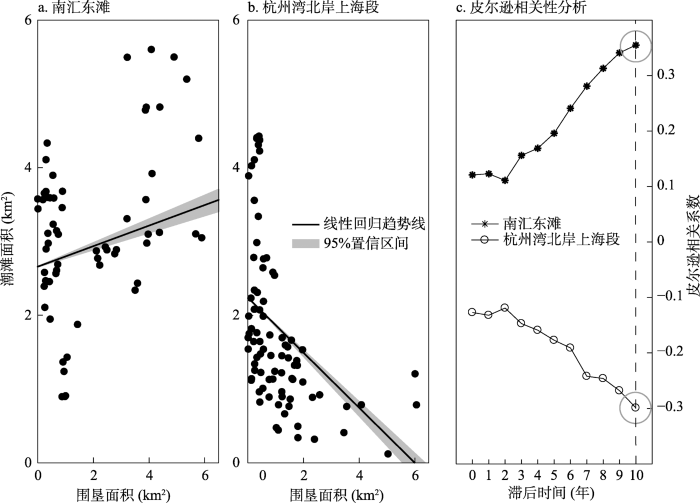
图10
杭州湾北岸潮滩围垦与自然淤涨滞后相关性分析
Fig. 10
Lag-correlation analysis between tidal flat reclamation and natural siltation in North Hangzhou Bay
在大规模人类围垦作用下,盐沼植被的生境被破坏,改变了潮滩自然环境条件,增大近岸风浪,因此干扰了潮滩盐沼植被的正常生长演替, 甚至导致盐沼植被的逆向演替[36]46-47。例如,在2020年长江口滩涂湿地围垦加剧影响下,自然岸段植被面积明显小于长江口生态保护区内的植被面积[37]。而且,人类围垦产生不利于盐沼植被生长的负面效应[38],进而影响植被促淤作用,导致潮滩淤长效率降低[39]。本研究进一步证实了盐沼植被对近岸风浪具有显著消减效应,能够在波浪到达海堤前起到缓冲作用,形成对堤防坡脚的防护作用,而人工围垦导致潮滩植被减少进一步导致近岸风浪大增,因而失去了海岸防护的作用。本研究通过探讨围垦活动对沿岸潮滩和植被的影响分析近岸波浪削减效应,旨在探索构建新型防洪综合体的防灾机理,从而为降低风暴潮引起的洪涝提供理论依据。
5.2 人类围垦对杭州湾北岸越浪的影响
为满足土地利用需求,自20世纪50年代以来,杭州湾北岸实施了大规模滩涂围垦和筑坝工程[40,41]。50年代初期围垦仅发生在高潮滩以上位置,但自80年代以来围垦逐渐向中、低潮滩延伸[41]。高潮滩围垦和筑坝被认为有利于防洪安全[24,42]。但中、低潮滩围垦将加大沿岸水深,随之而来的沿岸波浪增强和越浪放大效应不容忽视。此外,研究表明杭州湾北岸已从冲淤平衡区转变为侵蚀区[40],将进一步导致未来潮间带侵蚀,加大溃、漫堤引发的洪涝灾害。因此,大量潮间带和潮下带围垦已经对杭州湾北岸洪水变化造成负面影响。与南汇东滩淤积型岸段波浪高度回落的历史变化相比,若在杭州湾北岸侵蚀型岸段加设人工促淤措施修复潮滩,能有效降低近岸波浪高度,从而减轻杭州湾北岸的综合洪涝灾害[43]。
本实验通过杭州湾北岸多重现期极端风暴潮影响下波浪传播模拟分析,表明近岸波浪高度-波浪越堤和潮滩地形-堤防高度密切相关。而且,当海水达到一定高度,获得足够势能甚至会摧毁堤坝,导致溃堤,形成更极端洪涝风险[44]。本研究通过模拟预测的波浪高度与上海市现有海堤防洪标准和未来海平面上升及地面沉降下实际海堤高度进行比较,得到不同极端风暴潮影响下杭州湾北岸的越浪。结果表明到2050年和2100年杭州湾北岸的越浪逐年增大,而滩涂缺失是导致当地海岸洪涝加剧的直接原因。相比之下,南汇东滩为淤积型海岸,在自然潮滩淤涨作用下洪涝风险变化受人类围垦影响较小。同时,模拟结果显示南汇东滩的实际洪涝风险变化与杭州湾北岸其他地方存在明显差异,即南汇东滩随着海堤围垦,其波浪高度在迅速变高后又明显回落,滞后期大致为8~10年,这与当地特殊沉积动力环境和潮滩人工促淤修复作用密切相关[45]。
5.3 人工潮滩修复对生态防洪的意义
与传统“硬”质海堤相比,本文重点关注潮间带“软”措施的防洪效应。数值模拟表明,滩涂和盐沼植被是粗糙下垫面,可增大水流摩擦阻力,削减沿岸波浪高度,同时植物根系保滩固岸,具有减小泥沙侵蚀,达到促淤保滩作用[46],这对改变滩涂水动力、泥沙沉积动力以及滩涂冲淤过程具有重要意义。虽然历史防洪经验证明“硬”质海堤在防治海岸洪水方面得到普遍认可[6]79,但未来地面沉降、海平面上升以及不断增强的极端风暴潮强度引起的环境变化等多种不确定性因素对传统“硬”质堤防的防护有效性造成重大挑战[6,7]。随着坝体老化,未来维护成本不断增加,因此不断加高加固海堤具有不可持续性[33]1-2。相反,生态“软”措施具有动态自适应环境变化的能力,而且滩涂拓宽、种植盐沼具有美化环境,提供“硬”质堤防不具备的生态系统服务价值[18]278-279。
此外,利用数值模型的大范围空间模拟预测能力,可以定量评估整条杭州湾岸线防洪脆弱区的空间分布,计算滩涂修复所需的最小潮滩宽度和盐沼面积、种类需求等。模拟结果表明,通过合理规划潮间带宽度、抬高潮滩地形及在高风险区岸段种植盐沼植被可有效降低未来防洪脆弱区的洪涝风险。同时,通过敏感性测试可以计算复合型防洪综合体达标所需的最小潮滩宽度、上附植被特征及最低海堤高度的组合关系,使未来整条杭州湾北岸洪涝风险降到最低。因此,本研究可为高强度人类围垦下杭州湾北岸越浪风险评估、受损岸线修复和未来生态宜居性海岸带规划和建设提供参考价值。
6 结论
本研究基于水动力数值模型,利用2019年实测海堤高度和遥感解译的历史潮滩和盐沼植被变化及预测的未来海平面上升和堤坝沉降可能性,评估现在及未来杭州湾北岸洪涝变化情况。主要结论为:当前200年一遇风暴潮影响下杭州湾北岸没有出现明显越浪现象,洪涝风险较小,但在1000年一遇风暴潮影响下,金山滨海公园岸段水位已接近堤顶高度;到2050年200年一遇风暴潮影响下杭州湾北岸存在一定洪涝风险,金山滨海公园岸段出现越浪现象,越浪高度为0.12 m左右;到2100年200年一遇风暴潮影响下,杭州湾北岸上海段存在较大洪涝风险,约30%的岸段出现严重越浪,其中碧海金沙附近越浪高度接近0.5 m,金山滨海公园岸段越浪高度接近1 m。
采用生态性潮滩修复的方法对高风险岸段重新规划设计,恢复一定宽度潮滩之后重新运行模型。以2050年和2100年高风险岸段不发生明显越浪为标准,确定复合型防洪综合体达标需要的最小潮滩宽度及上附植被特征。主要结论为:到2050年需重点修复的岸段是金山滨海公园附近,须平均拓宽0.7 km、抬高1.3 m,修复岸线总长度约13.5 km,修复潮滩总面积为7.7 km2。在200年一遇风暴潮影响下测试表明有效波高明显下降到堤顶以下,消浪效果明显,说明采用潮滩生态性修复方法可行性较好;到2100年需整体修复杭州湾北岸潮滩,平均拓宽500~1000 m,地形抬升1.3 m,修复总长度约100 km,修复总面积为75.4 km2,且需在金山滨海公园岸段和奉贤海岸种植海三棱藨草增加摩擦阻力。敏感性测试表明,200年一遇风暴潮影响下消浪效果显著,但奉贤和金山部分岸段总水位仍十分接近堤顶高度,需同时进一步加高、加固该岸段原有硬质堤防,构建复合型防洪综合体,提高当地防洪可靠性。
致谢
真诚感谢匿名评审专家在论文评审中所付出的时间和精力,专家对本文图表方面提出了深入细致的修改意见,使本文获益匪浅。
参考文献
IPCC AR6《气候变化2022:减缓气候变化》主要结论和启示
The interpretation and highlights of IPCC AR6 WGIII report climate change 2022:mitigation of climate change
Linking the historic 2011 Mississippi River flood to coastal wetland sedimentation
Application of a fast stochastic storm surge model on estimating the high water level frequency in the Lower Rhine Delta
Performance evaluation of ERA 5 Extreme precipitation in the Yangtze River Delta, China
Accurate extreme precipitation information is crucial for disaster risk management, social and economic development security, and climate change research. Taking the Yangtze River Delta (YRD), China, a high-impact area of extreme precipitation, as an example, this study evaluates the spatiotemporal performance of extreme precipitation in the latest fifth-generation reanalysis dataset from the European Centre for Medium-Range Weather Forecasts (i.e., ECMWF ERA5) for 1961–2018 based on surface observational precipitation data. The results showed that the 90th-percentile threshold of extreme precipitation extracted from ERA5 data with a daily precipitation amount >1 mm is closer to the actual observations. The ERA5 data can effectively capture the spatiotemporal patterns of the observed extreme precipitation in the YRD. The ERA5 data can successfully represent the seasonal cycle and interannual variability of daily, daytime, and nighttime extreme precipitation. However, the daytime (nighttime) extreme precipitation frequencies and amounts tend to be overestimated (underestimated) for the period 1961–2000, whereas they were significantly underestimated for the period 2000–2018. The trend estimation of seasonal and annual extreme precipitation in ERA5 needs to be improved. The ERA5 data revealed that the extreme precipitation in the YRD was dominated by large-scale precipitation, followed by convective precipitation, but their long-term trends were not clear. This study has conducted a detailed and reliable evaluation of the ERA5 extreme precipitation data. The findings serve as valuable guidance and provide accurate references to extreme climatic variables for data users and algorithm developers.
Changes in population exposure to extreme precipitation in the Yangtze River Delta, China
Ecosystem-based coastal defence in the face of global change
Climate change impacts on rural poverty in low-elevation coastal zones
Wave attenuation over coastal salt marshes under storm surge conditions
Coastal projects in China: From reclamation to restoration
Tidal-flat reclamation aggravates potential risk from storm impacts
Have coastal embankments reduced flooding in Bangladesh?
From the 1960s, embankments have been constructed in south western coastal region of Bangladesh to provide protection against flooding, but the success of the polder programme is disputed. We present analysis of floods during the years 1988-2012, diagnosing whether the floods were attributable to monsoonal precipitation (pluvial flooding), high upstream river discharge into the tidal delta (fluvio-tidal flooding), or cyclone-induced storm surges. We find that pluvial flooding was the most frequent, but typically resulted in less flooded area (11.44% of the region on average) compared with the other forms of flooding. The greatest area of inundation (48% of total area) occurring in 2001 as a consequence of fluvio-tidal and surge flooding, whilst cyclone Sidr in 2007 flooded 35% of the area. We modelled these different forms of inundation to estimate what flooding might have been had the polders not been constructed. For the 'no embankment' counter-factual scenario, our model demonstrated that because of a combination of subsidence and inadequate drainage, construction of the polders has increased the pluvial flooded area by 6.5% on average (334 km(2)). However, during the 1998 fluvio-tidal flood, the embankments protected an estimated 54% of the area from flooding. During the cyclone Sidr storm surge event, embankment failure in several polders and pluvial inundation resulted in 35% area inundation, otherwise, the total inundation would have been 18% area. We conclude that whilst polders have provided protection against storm surges and fluvio-tidal events of moderate severity, they have exacerbated more frequent pluvial flooding and promoted potential flooding impacts during the most extreme storm surges. (C) 2019 Elsevier B.V.
Marsh resilience to sea-level rise reduced by storm-surge barriers in the Venice Lagoon
The value of China's coastal wetlands and seawalls for storm protection
Field-based decadal wave attenuating capacity of combined tidal flats and salt marshes
崇明岛南侧盐沼潮滩消能状态研究
Research on the wave energy dissipation over salt marsh tidal flat in the south of Chongming Island
Morphological wave attenuation of the nature-based flood defense: A case study from Chongming Dongtan Shoal, China
Overestimation of marsh vulnerability to sea level rise
Tidal flat-wetland systems as flood defenses: Understanding biogeomorphic controls
Wave overtopping of sea dikes with very shallow foreshores
Identifying knowledge gaps hampering application of intertidal habitats in coastal protection: Opportunities & steps to take
Comparing ecosystem engineering efficiency of two plant species with contrasting growth strategies
Many ecosystems are greatly affected by ecosystem engineering, such as coastal salt marshes, where macrophytes trap sediment by reducing hydrodynamic energy. Nevertheless, little is known about the costs and benefits that are imposed on engineering species by the traits that underlie their ecosystem engineering capacity. We addressed this topic by comparing ecosystem engineering efficiency defined as the benefit-cost ratio per unit of biomass investment for two species from the intertidal habitat: the stiff grass Spartina anglica and the flexible grass Puccinellia maritima. These species were selected for their ability to modify their habitat by trapping large quantities of sediment despite their contrasting growth form. On a biomass basis, dissipation of hydrodynamic energy from waves (a proxy for benefits associated with ecosystem engineering capability as it relates to the sediment trapping capability) was strikingly similar for both salt marsh species, indicating that both species are equally effective in modifying their habitat. The drag forces per unit biomass (a proxy for costs associated with ecosystem engineering ability as it relates to the requirements on tissue construction and shoot anchoring to prevent breaking and/or washing away) were slightly higher in the species with flexible shoots. As a result, stiff Spartina vegetation had slightly higher ecosystem engineering efficiency, due to lower engineering costs rather than to a higher engineering effect. Thus, Spartina is a slightly more efficient rather than a more effective ecosystem engineer. Ecosystem engineering efficiency was found to be a species-specific characteristic, independent of vegetation density and relatively constant in space. Analyzing ecosystem engineering by quantifying trade-offs offers a useful way toward developing a better understanding of different engineering strategies.
Sensitivity of hurricane surge to morphological parameters of coastal wetlands
Stem breakage of salt marsh vegetation under wave forcing: A field and model study
Evaluation of the combined risk of sea level rise, land subsidence, and storm surges on the coastal areas of Shanghai, China
杭州湾南、北两岸潮滩变迁遥感动态调查
Remote sensing dynamic monitoring of tidal banks in the Hangzhou Bay
土地利用变化情景下杭州湾北岸极端洪灾风险评估
DOI:10.18306/dlkxjz.2021.08.009
[本文引用: 1]

杭州湾位于长三角平原,该区域分布着大量的潮滩与湿地。未来随着海平面不断上升,更易引发自然灾害,尤其是风暴潮灾害,将使该地区社会经济发展面临巨大冲击。论文以多年土地利用与资产数据为基础,基于土地利用和资产的未来变化预测,结合多种未来极端洪灾情景,开展杭州湾北岸承灾体与暴露时空演化模拟,评估了上海市杭州湾北岸洪涝灾害风险。研究结果表明:从空间分布格局上看,现状情景下单位面积损失资产值的高值出现在浦东新区南部,而未来情景下单位面积损失值的高值覆盖整个杭州湾北岸南部沿海区域和金山区北部区域。就整个研究区而言,随着GDP的增长及极端洪灾情景下的暴露和淹没范围的增大,暴露资产和损失资产都在增长,年期望损失从现状情景的0.65亿元增长到未来典型浓度路径(RCP8.5H)情景下的3.04亿元。从风险评估结果来看,杭州湾北岸易遭受特大洪灾,必须实施洪灾风险敏感的城市规划,更新该地区的居民点和基础设施规划标准和规范。同时,应采取综合防范措施,加强杭州湾沿岸防洪能力。论文可为该区域未来城市规划、洪水风险应对措施和城市的韧性建设提供有效参考。研究方法相比传统的仅以当前土地利用及资产价值情景评估未来经济损失的方法更为合理有效,可为其他沿海地区的风险评估提供方法借鉴。
Risk assessment of extreme flood in the north bank of the Hangzhou Bay under land use change scenarios
The Hangzhou Bay, located in the Yangtze River Delta, is characterized by broad distribution of tidal flats and wetlands. As sea levels continue to rise in the future, natural hazards, especially storm surges, will be more likely to occur, which will have a great impact on the socioeconomic development of the region. Based on multi-year land use and assets data, this study conducted a simulation of the spatiotemporal change of elements at risk and exposures in the north bank of the Hangzhou Bay. The simulation is based on predictions of future variations in land use and assets and multiple extreme flooding scenarios, in order to assess the losses of flood disasters in the region. The results show that: 1) High values of asset losses per unit area under the current scenario appear in the south of Pudong New District. In future scenarios, high values of asset losses per unit area will cover the entire southern coastal area and the northern Jinshan District in the north bank of the Hangzhou Bay. 2) The entire study area will witness a growth in asset exposure and losses under extreme flooding scenarios as the GDP and the exposed and inundated area increase. The expected annual damage will rise from 65 million yuan under the current scenario to 304 million yuan under the representative concentration pathway (RCP) 8.5H scenario in the future. The risk assessment results indicate that the north bank of the Hangzhou Bay is susceptible to extraordinarily large floods. Thus, risk-sensitive urban planning must be implemented. The standards and specifications on residential communities and infrastructures in the region must be updated. Meanwhile, comprehensive preventive measures must be taken to enhance the flood control capabilities along the banks of the Hangzhou Bay. This study can provide a basis for decision making of risk-based urban planning, flood-risk adaption measures, and resilience improvements within the study area. The proposed research method is more reasonable and effective than the traditional methods of assessing future economic losses, which are often based only on current land use and asset values. It can also provide a methodological reference for risk assessments of other coastal regions.
Numerical simulation of mid-Holocene tidal regime and storm-tide inundation in the south Yangtze coastal plain, East China
长白山地区暴雨特征及重现期几种计算方法对比
Characteristics of rainstorm and comparison of several calculation methods about recurrence period in Changbai Mountain Area
An examination of estuary stability in response to human interventions in the South Branch of the Yangtze (Changjiang) estuary, China
MIKE21谱模型在台风浪数值模拟中的应用
Application of MIKE21 spectral model in numerical simulation of typhoon waves
风暴过程中潮滩悬沙浓度和悬沙输运的变化及其动力机制: 以长江三角洲南汇潮滩为例
Variations of suspended sediment concentrations and transport in response to a storm and its dynamic mechanism: A study case of Nanhui tidal flat of the Yangtze River Delta
全球平均海平面上升的瞬时速率
The instantaneous rate of global mean sea level rise
长江河口南汇嘴潮滩圈围工程前后水沙运动和冲淤演变研究
Research on the movement of water and suspended sediment and sedimentation in Nanhui spit of the Yangtza Estuary before and after the construction of reclamation projects on the tidal flat
崇明东滩盐沼植被扩散格局及其形成机制
The expansion pattern of saltmarshes at Chongming Dongtan and its underlying mechanism
潮滩围垦对海岸环境的影响研究进展
Progress on environmental effects of tidal flat reclamation
江苏沿海滩涂围垦耕地质量演变趋势分析
DOI:10.11821/dlxb201711009
[本文引用: 1]
淤涨型沿海滩涂作为中国重要湿地和耕地后备资源,承担着生态保护、社会保障、经济发展等多重服务功能。选取江苏中部淤涨型滨海滩涂开展实证分析,分析围垦年限为0~40年滩涂垦区耕地质量因子空间差异,采用“时空代换”方法揭示滨海滩涂围垦后耕地质量的演变趋势,为沿海滩涂围垦区耕地资源可持续利用提供决策参考。结果表明:江苏中部沿海滩涂土壤总体呈现盐碱度高、养分贫瘠等特征且土壤理化性质变异程度高,土壤质地呈现显著南北和陆海梯度特征。滩涂垦区围垦初期地形、植被状态和围垦后滨海滩涂转变为耕地路径对耕地质量演变趋势均具有重要影响。沿海滩涂转为耕地路径由垦区自然条件、开发主体、开发规模等因素共同作用,江苏中部沿海滩涂转为耕地路径已从“盐生植被→养殖水体→耕地”转变为“盐生植被→耕地”,该转变缩短了滩涂转为耕地的周期,但同时也带来围垦滩涂撂荒闲置现象。围垦后沿海滩涂土壤逐步向耕地土壤转变,耕地质量因子演变趋势可分为四种:上升型,如土壤全磷、有效磷、粘粒含量;下降型,如土壤砂粒含量;下降—上升型,如有机质、全氮、碱解氮和CEC;上升—下降型,如土壤盐分和pH。围垦初期,滩涂土壤脱离海水环境,土壤有机质发生矿化过程呈现下降趋势,土壤盐分和pH受到蒸发和蒸腾作用急剧上升;围垦中期,受到人类耕作作物秸秆等有机物输入以及施肥的影响,土壤有机质、养分等呈现上升趋势,土壤盐分和pH呈现下降趋势;围垦后期,耕地质量因子受到耕作管理影响存在一定幅度的波动,由于沿海滩涂垦区耕地形成时间短,耕地质量对耕作管理等因素敏感度高。
Cropland quality evolution following coastal reclamation at the prograding tidal flats of Jiangsu province, China
Coastal prograding tidal flats are important wetlands and reserve resources of cropland in China, which provide the services of ecological protection, society security, and economic development. Taking the reclamation zones on the prograding coast of Jiangsu as a case study, this paper analyzed soil quality at the reclamation zones with a duration of 0-40 years to indicate the evolution of cropland quality following reclamation for sustainable use of cropland, by using the method of "space for time substitution". The results show that cropland soils had high salinity but low nutrients. The variation of soil physical and chemical properties is high in the coastal reclamation zones, and the soil particle sizes had obvious gradients of North-South and Land-Sea. The factors such as topography, vegetation status, and the path of tidal flats to cropland had significant impacts on cropland quality evolution following coastal reclamation. The path of tidal flats to cropland were jointly decided by physical condition of reclamation zones, development entity, and development scale in the coastal area of Jiangsu. The cropland trajectories have changed from "halophytes→aquaculture pond→cropland" to "halophytes→cropland" in the central part of the province's coastal area. This change shortened the period of tidal flats to cropland, but led to idle tidal flats after reclamation. The soils of coastal tidal flats have gradually transferred into soils of cropland. The changing trends of soil properties were divided into four types. The first one was the type of increase, such as soil total phosphorous, available phosphorous, and clay content. The second one was the type of decrease, such as sand content. The third one was the type of increase then decrease, such as soil salinity and pH. The fourth one was the type of decrease then increase, such as soil organic matter, total nitrogen, available nitrogen, and capacity of exchange cations. At the initial period of reclamation, soil organic matter showed a declining trend because of the process of mineralization. The soil salinity and pH increased due to transpiration and evaporation. At the middle period of reclamation, soil organic matter and nutrients increased because of the fertilization and organic matter input via human cultivation. Soil salinity and pH decreased as a result of precipitation and water resource facilities. At the later period of reclamation, the factors of soil quality fluctuated under the effect of cultivation management. The quality of cropland at the reclamation zones was fragile and sensible to cultivation management, because of the relatively short history of coastal reclamation.
1959—2018年九段沙地貌演化特征及动力机制
Morphological evolution and dynamic mechanics of the Jiuduansha Shoal(China) during 1959-2018
Local human activities overwhelm decreased sediment supply from the Changjiang River: Continued rapid accumulation in the Hangzhou Bay-Qiantang Estuary system
The influence of seasonal climate on the morphology of the mouth-bar in the Yangtze Estuary, China
Flood risk and its reduction in China
Despite massive flood protection efforts in China, undertaken since the ancient times, disastrous floods continue to plague the country. In this paper, we discuss changes in flood hazard and flood risk in China. First, we review published results (including our own works) on change detection in observed records of intense precipitation, high river flow and flood damage in China. We provide information on essential features of extreme floods in last decades - floods on large rivers, urban floods, and flash floods. Next, we review available projections for the future (including our own results), related to intense precipitation, high river flow and flood damage in China. We try to interpret the difference in flood hazard projections obtained in various publications. Since the spread of river flood hazard projections is large, projections have to be interpreted with caution, because of the impact on decisions related to climate change adaptation, flood risk reduction, and water resources management. We review flood risk reduction strategies in China, focusing on the present situation and division of responsibilities. China has embarked upon an ambitious and vigorous task to improve flood preparedness, by both structural ("hard") defences, such as: dikes, dams and flood control reservoirs, and diversions, as well as non-structural ("soft") measures: spatial planning and zoning; watershed management (source control), flood forecasting and warning systems; and awareness raising. The strategy of flood mitigation includes flood retention and urban water management to alleviate the burden of flash and urban flooding.
漫溃堤洪水联算全二维水动力模型及应用
Comprehensive two-dimensional associate hydrodynamic models for overflow and levee-breach flood and its application
Spatial-temporal evolution of the eastern Nanhui mudflat in the Changjiang (Yangtze River) Estuary under intensified human activities
