

1 引言
国内学界对乡村人口迁移流动的研究主要着眼于“人的城镇化”,更为关注乡城流动人口在流入地的落户意愿[8]、定居意愿[9]、购房行为[10]、创业行为[11]和社会融入[12]等,在乡村振兴背景下也愈加重视人口回流意愿和效应的分析[13,14],探讨乡村人口外流较少。少量相关研究主要沿两条路径展开:① 基于人口普查分县数据和空间统计学方法的宏观格局特征分析。陈坤秋等从人口迁移视角出发,采用人口流出率与流入率的差值测度乡村人口空心化,发现该现象在县域尺度普遍存在,空心化程度高-高集聚单元一直集中分布于东南沿海地区,并指出县际人口迁移与省际人口迁移呈现不同样貌,“胡焕庸线”以东、“秦岭-淮河”以南的人口密集地区亦是县域乡村人口外流的重点源区[15];王良健等采用流出人口占比等不同指标的同一主题研究也得到了基本相同的结果,显示浙江、福建、广东等人口净流入的东南沿海发达省份是中国县域乡村人口空心化程度的高值区、高增长区和高-高集聚区[16];郭远智等则以户籍人口与常住人口比表征人口外流率进行计算分析,结果表明中国县域乡村人口外流程度及其空间集聚性呈增强趋势,外流率高的净流出Ⅱ型和Ⅲ型县级单元均主要分布在东南沿海丘陵地区[17]。② 基于人口抽样调查数据和案例分析方法的微观类型分异研究。顾康康等在安徽省3大地理区域内选择6个代表性村庄进行实地调研,发现皖北、皖中和皖南地区乡村人口的流入地和定居地选择不同,村庄人口流动的时空路径类型存在明显的地域差异[18];赵美风等利用1%人口抽样调查分村数据,综合人口流动强度和活跃度2个指标,划分出云南省玉龙自治县人口流动的4种村域类型,揭示出村域尺度人口流动特征和类型的空间分异性[19];龙茂乾等以福建省上杭县的311个村庄为样本探讨乡村人口的梯度迁移,研究结果也印证了不同村庄在外出人口规模和流向等方面的异质性[20];赵宁宁等通过分层抽样在湖南省岳阳市选定3个典型村进行实证研究,进一步确认了乡村人口外流规模、程度、方向和距离等因村庄类型而异[21]。
上述研究共同揭示了乡村人口外流的空间聚类和类型分异特征,识别出其不同层级(个体、家庭、村庄等)和不同维度(自然、社会、经济、政策等)的影响因素,为本文提供了有益参考,但也存在以下不足:① 在研究尺度上,未能兼顾范围广度和数据粒度。地理格局具有尺度依存特性[22],既有全国范围的乡村人口外流研究是基于县域尺度,其结果不能直接被转换到更精细的村域尺度,而村域尺度的分析仅以典型县市为案例区,有必要扩大研究范围。② 在研究内容上,对空间格局的现象发现和机理认知不足。已有研究侧重于刻画乡村人口外流的空间相关性和空间异质性等空间特征,也关注流出人口的空间行为,但对“有价值而非常识”的空间现象缺乏深入挖掘和理论解释。③ 在研究对象上,未进一步聚焦有重要价值和研究紧迫性的特定类型村庄。不同于一般乡村聚落,传统村落具有丰富资源和多元价值,兴衰存亡关乎乡村重构与建设的成败[23],取决于以人为主体和载体的各类要素留乡、返乡和下乡,亟需对其人口流失总体状况展开研究。
基于以上认知,本文以4223个国家级传统村落为研究样本,在全国范围和村级尺度,对传统村落人口外流格局特征及其影响机制进行空间分析和理论建构,试图回答和解决以下问题:① 中国传统村落的人口外流是否也存在空间依赖性和空间集聚性,并因此在特定地方集中,形成辐散流场?② 不论实证结果为何,能否针对其形成一个具有解释力的理论机制?
2 数据与方法
2.1 研究样本与数据来源
囿于大样本数据的可获性,兼顾考虑数据的丰度、一致性和时效性,本文以第四批和第五批列入中国传统村落名录的4264个村落为研究样本。剔除村落户籍人口和常住人口数据均缺失或不完整的少量样本后,研究得到4223个有效样本(图1)。该样本的容量占到全部五批6819个国家级传统村落的61.93%,其中有第四批村落1576个、第五批村落2647个,分别占到该批村落总数的98.62%、99.29%。
图1
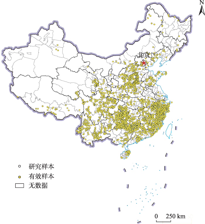
图1
研究样本空间分布
注:该图基于自然资源部地图技术审查中心标准地图(审图号:GS(2019)1697号)绘制,底图边界无修改。
Fig. 1
Spatial distribution of research samples
研究样本及其户籍人口、常住人口、始建年代等属性数据主要来源于住房和城乡建设部网站关于第四批、第五批拟列入中国传统村落名录的村落基本情况的公示文件,并依托中国传统村落数字博物馆(
2.2 测度指标
2.3 研究方法
2.3.1 探索性空间数据分析(ESDA)
探索性空间数据分析是一系列空间数据分析方法和技术的集合[27],旨在通过对地理要素分布的定量描述与可视化,发现空间依赖和空间聚类现象。其中的Global Moran's I指数和Moran散点图可分别用来测度中国传统村落人口外流在全局和局部的空间自相关性;热点分析(Getis-Ord Gi*)工具可用来识别具有统计显著性的传统村落人口外流率热点(被高值样本包围的高值样本)和冷点(被低值样本包围的低值样本),揭示两者在空间上发生聚类的具体位置。
2.3.2 标准差椭圆(SDE)
2.3.3 反距离权重插值(IDW)
式中:
2.3.4 加权核密度分析(WKDE)
核密度分析是一种用于估计点状要素在不同空间位置上概率密度函数的非参数方法,结果连续性好[31],在地理要素集聚格局研究中应用广泛。采用普通的核密度模型可显示传统村落分布集中的地域,但难以同时反映不同村落人口外流程度的差异。为此,本文引入加权核密度模型[32],识别净流出型村落密度和人口外流强度“双高”的核心区,辅助确定中国传统村落人口外流场的空间范围。在计算核密度时,本文将净流出型村落按其人口外流程度由高到低划分为3级,相应赋予权重0.6、0.3和0.1;经多次调试后,将带宽确定为150 km。根据所得密度值,核心区可进一步区分为一级、二级和三级,其中一级核心区是净流出型村落聚集和人口辐散的主中心。
3 中国传统村落人口外流场的空间识别
3.1 传统村落人口外流特征分析
3.1.1 数量特征
从研究样本来看,中国传统村落的人口流动呈现出2个特点(图2):① 人口外流的普遍性。人口净流出的样本有3325个,占比高达78.74%,即大多数传统村落都存在人口外流现象;净流出型村落不仅在数量上居于主体,在时间上涉及不同历史时期(始建年代远至春秋时期、近至1949年后),还在空间上覆盖了中国内地除上海外的全部省份和全国2/3以上(67.27%)的地级行政区。② 人口外流的严重性。样本人口外流率均值为14.31%,明显高于学界用以判别空心村的同一指标阈值(5%)[25];人口外流率不低于该阈值的样本占比达70.09%,亦高于全国行政村普查抽样数据②(②全国行政村普查抽样数据来源于2016年第三次全国农业普查,转引自文献[25]。该数据是在全国行政村普查表数据记录中抽取的样本。样本村有68906个,占到全国行政村总数的12.30%,有较高的代表性,能反映中国村庄人口流动的一般情况。)计算结果(57.50%),可见中国传统村落总体上存在严重的人口空心化问题。细分类型来看,净流出型村落中人口重度外流(外流率大于平均值即27.56%)的有1408个,占到全部样本的1/3(33.34%);人口外流率高达50%以上并因而呈衰退趋势的村落也有504个。
图2
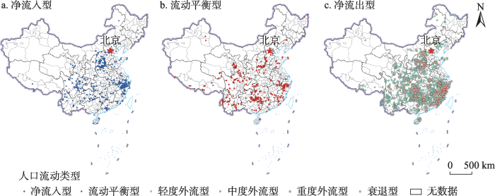
图2
中国传统村落的人口流动类型
注:该图基于自然资源部地图技术审查中心标准地图(审图号:GS(2019)1697号)绘制,底图边界无修改。
Fig. 2
Types of population floating of Chinese traditional villages
3.1.2 空间特征
基于样本位置及人口外流率属性,运用GeoDa软件进行空间自相关分析,检验传统村落的人口外流是否存在空间依赖和空间集聚现象。结果显示,样本总体和净流出型村落人口外流率的Global Moran's I指数分别为0.046和0.301,正态统计量z值分别为5.701和28.848。两者的指数值均为正且通过了置信度为99%的显著性检验,表明中国传统村落的人口外流存在显著的空间依赖性,某个村落的人口外流率会受到相邻村落的正向影响,这种相互作用在净流出型村落中体现得更为强烈。
进一步采用Moran散点图分析传统村落人口外流在局域的空间依赖性(图3),统计得到位于第一和第三象限的样本比例分别为35.99%和39.92%(合计达75.91%),说明中国传统村落的人口外流率在空间上趋向于局部正自相关,主要表现为低-低集聚(LL)和高-高集聚(HH)模式;净流出型村落的人口外流也呈现出相同特征,人口外流率相近的村落倾向于集中分布。
图3
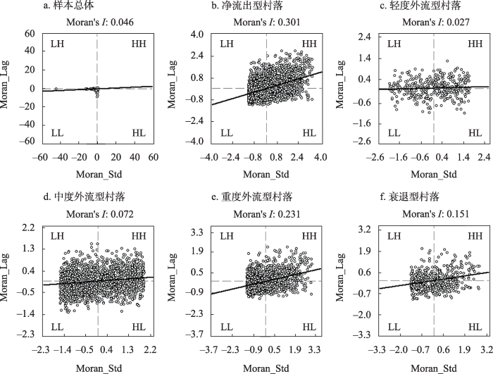
图3
中国传统村落人口外流率的Moran散点分布
Fig. 3
Moran scatter diagram of population outflow rate of Chinese traditional villages
同理,分别算得轻度外流型、中度外流型、重度外流型和衰退型村落人口外流率的Global Moran's I指数为0.027、0.072、0.231和0.151(图3),正态统计量z值为0.952、4.951、14.794和6.040(除轻度外流型村落外均通过了0.01水平的显著性检验)。可见,流出活跃的传统村落人口外流的空间依赖性更强,更趋于在空间上发生聚类。并且,在不同类型的净流出型村落中,人口外流率空间分布表现为高值集聚模式的样本都占到20%以上。
3.2 传统村落人口外流源区识别
前文已揭示出传统村落人口外流率的空间聚类分布特征,但其高值集聚的地方即人口辐散源地还有待探明。为此,本文依次运用加权标准差椭圆、热点分析和反距离权重插值等方法,对中国传统村落人口外流的主要源区进行多重分析和综合研判。
3.2.1 人口外流活跃区
基于采用人口外流率分级结果赋权的传统村落位置点,应用SDE方法计算得到样本总体和净流出型村落加权标准差椭圆的基本参数(表1),并对两者进行空间可视化(图4)。① 从椭圆面积来看,两者分别仅占中国陆地和水域总面积的9.02%和8.64%,说明并再次验证了传统村落人口外流的空间集聚性。② 从椭圆位置来看,两者都位于“胡焕庸线”东南一侧,前者大部和后者均在丁金宏等划定的中国人口迁移流场的“东南流域”内[33]。③ 从椭圆范围来看,传统村落人口外流的活跃区在中国地势第三级阶梯上、黄河干流与珠江主干流之间,主要涉及中东部地区的10个省份。④ 从椭圆中心来看,传统村落人口外流的重心落在长江中下游南岸,位于江西九江市境内。⑤ 从椭圆方位角和长短轴来看,传统村落人口外流率的空间分布总体呈“东南-西北”格局,主趋势方向为“南(偏东)-北(偏西)”。最后综合椭圆扁率等参数来看,相较样本总体,净流出型村落人口外流的地理集中性和方向性更显著、重心和指向更偏东南。
表1 中国传统村落加权标准差椭圆的基本参数
Tab. 1
| 加权标准差 椭圆类型 | 加权标准差椭圆参数 | |||||
|---|---|---|---|---|---|---|
| 面积(万km2) | 中心坐标 | 方位角(°) | 长半轴(km) | 短半轴(km) | 扁率 | |
| 样本总体 | 129.02 | (116.12°E, 29.37°N) | 143.01 | 732.47 | 560.71 | 0.23 |
| 净流出型村落 | 123.50 | (116.90°E, 28.85°N) | 122.98 | 709.01 | 554.45 | 0.22 |
图4
图4
中国传统村落人口外流率的标准差椭圆
注:该图基于自然资源部地图技术审查中心标准地图(审图号:GS(2019)1697号)绘制,底图边界无修改。
Fig. 4
Standard deviation ellipses of population outflow rate of Chinese traditional villages
3.2.2 人口外流热点区
标准差椭圆方法着重于全局评估,能从整体层面揭示中国传统村落人口外流现象发生的主体区域和主导方向,但不能反映其在局部的空间自相关性。故利用ArcGIS中的热点分析工具,从个体层面探察人口外流率的冷热点空间分布,进一步明晰传统村落人口辐散源所在。结果与图4呈现的一致,显示中国传统村落人口外流率的热点也都分布在黄河以南的中东部省份,且主要团聚在华东地区和长江以南(图5)。较之样本总体,净流出型村落人口外流率热点的分布更广,但最为集中的地域也在东南沿海地带,两者均在此形成了一个成簇密集、连续分布并跨越多省的热点区。热点不仅集群分布的区域明确,与冷点及其他不具统计显著性的样本的空间界限也很清晰,尤其是人口外流严重的净流出型村落与外流程度轻的村落以中国地势第二、三级阶梯分界线和黄河下游河段为界,分布泾渭分明。
图5
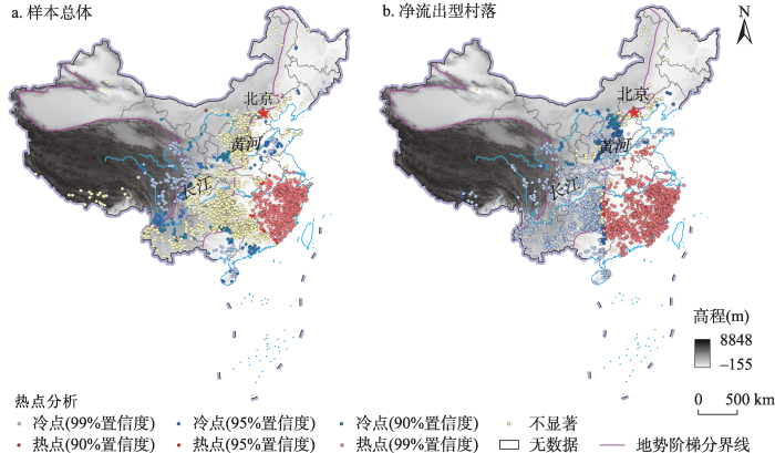
图5
中国传统村落人口外流率的热点分析
注:该图基于自然资源部地图技术审查中心标准地图(审图号:GS(2019)1697号)绘制,底图边界无修改。
Fig. 5
Hot spot analysis of population outflow rate of Chinese traditional villages
3.2.3 人口外流连绵区
热点分析的结果显示东南沿海地区是中国传统村落人口外流的主要源区,但这一源区的具体范围和空间形态还需明确。因而采用IDW算法,对样本点数据进行空间插值,将其转换为连续的面状数据,以便更为直观地刻画传统村落人口的强辐散源。结果表明(图6),中国传统村落人口外流率的区域差异显著,高值区的分布十分集中,在浙闽粤三省内形成了一个呈带状连绵分布的人口重度外流地带,其范围北至浙南、南至粤东,中间贯穿了福建全省。除这一人口外流连绵区外,其余样本人口外流率高值区大多属零星散布,且范围很小,仅在东北及蒙东等地区出现了因极值样本和插值方法局限导致的孤立圆或同心圆区域(即所谓“牛眼”现象)。对比来看,净流出型村落人口外流率的空间分异格局与样本总体不同,但两者人口外流“重灾区”的空间范围和形态基本相同,均在东南沿海诸河流域区和浙闽低中山地貌区内[34]。
图6
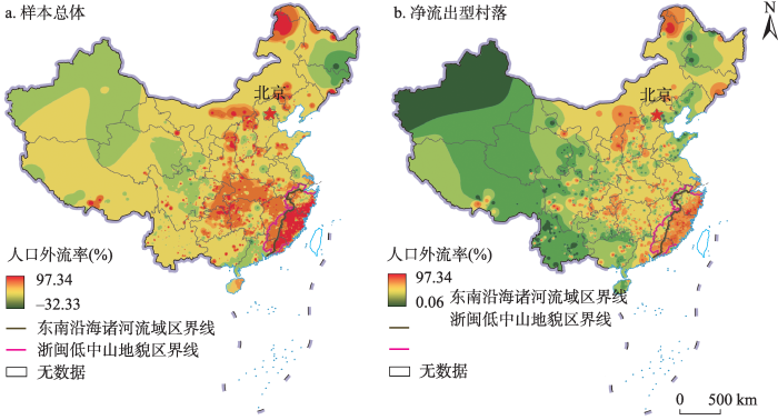
图6
中国传统村落人口外流率的空间分异格局
注:该图基于自然资源部地图技术审查中心标准地图(审图号:GS(2019)1697号)绘制,底图边界无修改。
Fig. 6
Spatial differentiation pattern of population outflow rate of Chinese traditional villages
3.3 传统村落人口外流场的界定
3.3.1 概念解析与范围确定
上文已识别出中国传统村落人口外流程度最深也是范围最大的源区即浙闽粤人口外流连绵区。以其为主体的区域在空间点模式分析和面模式分析中都是传统村落人口外流率高值的显著集聚区(图5、图6),同时也是净流出型村落高密度分布且人口高强度外流的一级核心区所在(图7a),是“多区”叠加之处,具有特殊性和唯一性。鉴于此,本文借鉴物理学中场的概念[35,36]和人口迁移空间模式研究中的辐散流场概念[33],将这一区域称为中国传统村落人口外流场。其由人之流动和互动产生,因人口“粒子”存在的波粒二象性而具有物理场的基本属性和特征:① 是某个物理量(传统村落人口外流率)在空间的分布;② 占据一个特定的区域且空间连续性突出;③ 场中的运动要素即物理量有特定的分布规律且相互作用。
图7
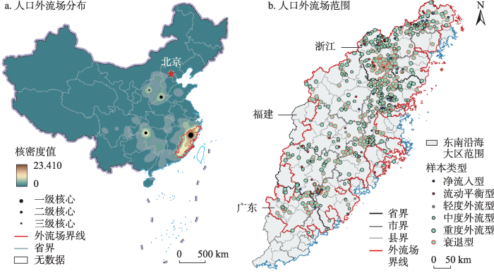
图7
中国传统村落人口外流场的分布和范围
注:该图基于自然资源部地图技术审查中心标准地图(审图号:GS(2019)1697号)绘制,底图边界无修改。
Fig. 7
The distribution and scope of population outflow field of Chinese traditional villages
本文以县级行政区为基本单元,主要依据传统村落人口外流连绵区、核心区的范围和净流出型村落的分布,兼顾考虑自然区域完整性和空间连续性,确定中国传统村落人口外流场在空间上涉及浙江3市(温州、台州、丽水),福建8市(除厦门外)和广东2市(梅州、潮州)的全部或部分辖区,共包含83个县(市、区)(图7b)。该场以浙闽交界地区为“场核”,与Skinner界定的东南沿海大区③(③Skinner以区域为基本视角和单位分析中国历史的结构,并立足人类交往的空间模式建构区域范畴,将帝制中国划分为包括东南沿海大区在内的9个宏观区域。)范围重合明显[37]4(图7b),是一个历史上就相对独立、有自身发展周期和逻辑的区域。
3.3.2 概况认知与问题提出
中国传统村落人口外流场2020年有户籍人口4368.24万人,常住人口3960.83万人,人口净流出407.41万人;常住人口城镇化率为59.96%,低于全国平均水平(63.89%)。可见,该场整体上吸纳和集聚人口的能力不足。进一步分析研究样本可知,场内共有样本652个,其中90.34%的样本人口净流出,66.56%的样本人口重度外流,因人口严重流失而有衰退趋势的村落占比也超过1/3(35.12%)。场内样本人口外流率的均值和全局Moran's I指数分别为37.87%和0.561,均显著高于样本总体(14.31%和0.046);平均净流出人口为458人,是样本总体值(162人)的2.83倍。
概括而言,场内传统村落人口外流的普遍性、严重性、关联性、规模性和区域性均突出。这是中国传统村落人口外流场的表征,也是其产生的直接原因,但为何其占据的是东南沿海的这一区域而非其他区域?换言之,该区域有何独特要素和属性,以至于仅在此形成了传统村落人口外流场?对以上问题的准确回答有赖于综合历史和现状深入认知该区域的独特性即地方性,是揭示中国传统村落人口外流场形成机制的前提和基础。
4 中国传统村落人口外流场的形成机制
4.1 基于地方性的乡村人口外流影响机理分析
(1)自然层。① 从自然区位来看,该场兼具中国大陆边缘与环南海地区边缘的双重角色,远离中原、僻处海隅(图8a),曾是《汉书》所谓“限以高山,人迹所绝,车道不通”的“不居之地”,并在山海之间因地势而形成背山面海、向海发展的格局。② 从地形地貌来看(图8b),该场的地形“骨架”由西、中两列与海岸线大体平行、斜贯全境的大山带构成,山间分布有众多互不贯通的河谷小盆地,山外狭长的滨海地带则以广布的丘陵和断续不相连的小块河口平原为主,整体因山川间阻和流水切割而形成支离破碎、崎岖难行的地表特征。③ 从河流水系来看(图8b),该场因降水丰富而形成稠密的河网,因地形多山而缺少大江大河,以众多独立入海的中小河流为主,且河流源短流急、水浅滩多,不利于开展内河航运。④ 从资源禀赋来看,该场素有“东南山国”“八山一水一分田”之称,人均土地资源占有量(0.352 hm2)仅相当于全国平均水平(0.688 hm2)的51.16%,坡度在6°及以下的土地面积占比(19.16%)远低于全国(54.91%),适宜开发利用的空间有限且功能重叠,建设用地供需矛盾突出,但海域和滩涂面积广阔,海岸线曲折绵长,通航条件优良的深水港湾众多,近岸岛屿星罗棋布,海洋资源丰富多样。
图8
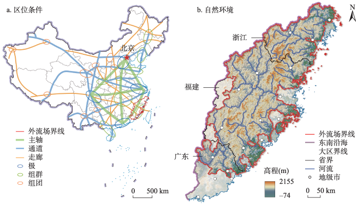
图8
中国传统村落人口外流场的区位条件和自然环境
注:该图基于自然资源部地图技术审查中心标准地图(审图号:GS(2019)1697号)绘制,底图边界无修改。
Fig. 8
Location conditions and natural environment of population outflow field of Chinese traditional villages
(2)生计层。① 该场濒临海洋的区位和海阔水深的自然条件,为生活在滨海地域的原住民提供了鱼、盐、港口和航路等生计资本和捕捞养殖、煮盐晒盐、航海运输、海洋贸易等生计方式,疍民等“水上人群”[41]更是生在江海、浮家泛宅、随处栖泊,处于散居流动状态。② 该场在南宋时即因生齿日繁而整体出现人稠地狭、田不供食、为生艰难的问题[42]。面对与内陆地区的交通阻隔,相对过剩的乡村人口只能“造船讨海”“向大海要田”[3,43],或采捕营生,或驾舟度日,或“贩番为命”,或移民谋生(如“过番”),或入海从盗[43],把生存压力转化为以海岸线为纽带、以海洋为通途的多样生计手段。③ 该场的自然本底和人地关系使得当地民众自古“多以海商为业”[37]5“半藉海船贸易为资生之计”[3]89,在改革开放尤其是人口流动相关政策限制放松后更是“市场在哪里,脚步就到哪里”,形成了“游贩四方”“四海为家”的行商和侨居传统并延续至今,发展出了为寻求更好商机而不断流动、跨越边界的生计策略和生活方式[44]38。④ 该场曾长期处于海防前线,改革开放前得到的国家政策支持和投资项目少,交通设施建设相对滞后、经济发展基础较为薄弱,至今仍是典型的沿海发达地区“经济洼地”。其人均GDP(59697元)略高于全国平均值(56909元)但明显低于东南沿海五省市(沪苏浙闽粤)平均值(89234元),第三产业产值占比(40.57%)低于全国和东南沿海五省市的平均水平(51.60%和52.55%)10个百分点以上。该场在国家综合立体交通网主骨架布局④(④图8a中的国家综合立体交通网主骨架布局依据中共中央、国务院2021年印发的《国家综合立体交通网规划纲要》(
(3)组织层。① 该场历史上远离王朝统治核心区,因政治区位的边缘性获得了一定自主性,社会秩序的建立和维持长期有赖于地方势力,从而为以宗族为基础的地方自治单位发展提供了充分的制度空间。稻作生产带来的农业剩余和水利合作需要[45]8,以及不利的生存环境和紧张的人地关系引发的竞争,进一步促进了宗族组织的发育和发达。并且,场内宗族与村落明显重叠、血缘与地缘高度结合,形成了大量单姓聚族而居、内部社会关系紧密的团结型宗族村落[45]23。② 场内村民的一致行动能力较强[45]36、惯于“走出去”[44]40,在集体流动的过程中利用亲缘、乡缘和业缘等传统的人际关系网络[46]189,逐渐形成了诸多稳定的“链式流动”通道,并在通道另一端的流入地建构出以非正式支持网络和宗亲会、同乡会、商会等制度化组织为支撑的“小生境”[3]445,为乡村流动人口“落脚”和适应提供了必要的社会空间,推动了人口流动的循环往复。传统网络作为一种社会资本和地方资产,不仅在引导人口流向和维系流入地“小生境”中发挥重要作用,还可经市场化改造而成为外出经营者跨区域动员和配置资源、组织商品生产和销售等的主要手段[44]53,是场内乡村流动人口经济和社会生活的共同组织基础。③ 该场因地形破碎、地理阻隔和移民历史等原因,形成了具有多元性和地域性的方言、习俗和民间信仰。这些正是特定社群身份的标志和认同的来源[3]24,有助于产生义务、互惠和团结,扩展移民网络,进一步促进场内乡村人口的外流。
(4)文化层。① 场内民众素来视经商为“第一等生业”,对商业利益有超越时代和阶层的普遍关注[3]47,形成了“好贾趋利轻别离”的社会心理和文化传统。“只博黄金不博诗”的大众行为在历史和实践中与浙东事功学派主张的“农商并重、义利并举”思想相整合,创造出了一个重商贾、好远游的独特文化环境[47]154。② 该场受到中国传统家族制的深远影响,并在改革开放后出现了相当普遍的乡村家族文化复兴[45]33,以家族为本位、强调共同利益和内部互惠的价值观深入人心。场内乡民总是自觉或不自觉地将生计安排和人生设计与家族认同关联起来[47]263,个体的商业和流动实践因而往往背负着光大祖业、改换家门的厚望。换言之,家族主义理念为经商逐利和迁移行为赋予了合理性甚至“敬祖尽孝”的意义,为场内乡村人口的向外流动注入了心理驱动力和道德能量。③ 场内民众并无安土重迁观念,向来视流动为理所当然[3]48,已将移民从典型的个体和家庭适应行为发展为群体共有的“惯习”,将流动从生活方式发展为自我认同和社会认同的重要内容,形成了一种具有地域根植性的特殊移民文化。
综上可知,该场不同层的地方性及其间和内部的互动,导致场内传统村落人口高强度、成规模流出(图9)。其影响机理主要如下:① 中国传统村落人口外流场“背山面海”的自然区位、“地狭海阔”的资源禀赋和“经济洼地”的发展现实共同推动人口向外播迁。② 该场的资源环境本底条件引致“靠海为生”“以海为途”和“四海为家”等富于流动性的生计和生活方式,产生了大量流动实践和经济型流动人口。③ 该场的政治区位和聚落生境有利于宗族组织及以其为根基的亲缘等“传统网络”的发展壮大,所积累的丰厚社会资本提高了传统村落人口外流的可能性。④ 该场“地形多山”“独流入海”的自然地理特征造就了众多相对独立的人居生态单元,在促进“宗族村落”发育的同时形成了多元文化和“多元社群”,提供了方言岛、信仰圈等更多强有力的传统村落人口迁移流动纽带。⑤ 该场在自然、生计和组织三层地方性的综合影响下,形成了“重商文化”“家族文化”“移民文化”三者相融互促的地域文化生态并内化为群体共享的迁移惯习,直接推动场内传统村落人口外流,同时又反作用于生计层和组织层的地方性,为两者中流动性的增强提供了不竭的动力。
图9
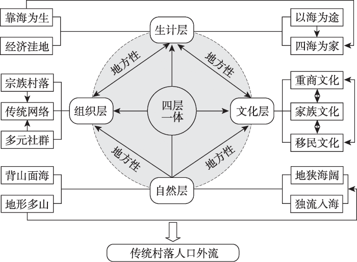
图9
地方性的构成及对传统村落人口外流的影响机理
Fig. 9
The composition of locality and its influencing mechanism on population outflow of traditional villages
4.2 传统村落人口外流场形成的双重机制揭示
图10
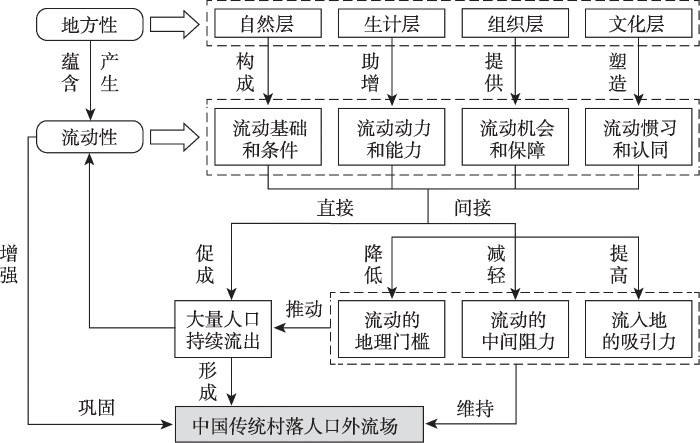
图10
中国传统村落人口外流场的形成机制
Fig. 10
Formation mechanism of population outflow field of Chinese traditional villages
(1)该场各层地方性中都蕴含或产生了不同程度的流动性:① 自然层的流动性较强,构成了场内人口流动的物质基础和区位条件。② 生计层的地方性形成了场内人口流出的驱动力,并因其高流动性而有助于人口流动能力的提高和流动资源的积累。③ 组织层的地方性跨区域存在,为场内人口提供了关键的流动机会和保障。④ 文化层的地方性塑造了场内人口流动的惯习和对流动的深层次认同。上述流动性的存在一方面直接促成了场内传统村落人口的大规模外流,另一方面通过降低流动的心理门槛(流出的意愿)、区位门槛(潜在目的地)和路径门槛(到达的途径)等地理门槛[49],减轻距离、成本、风险、政策、观念(如“人离乡贱”)、情感(如恋地情结)等流动中间阻力因素的影响,以及提高流入地的吸引力,助推了大量人口的持续流出。当场内传统村落的人口外流发展到一定强度和规模并形成“社会惯性”时[46]181,中国传统村落人口外流场得以建立。以上是该场形成的第一重机制即地方性驱动机制。
(2)当传统村落人口外流场形成后,每一次流动实践的完成、每一个流动人口的产生都会导致该场地方性中流动特质加强的变动,形成累积性循环发展趋势,从而使人口迁移流动逐渐部分独立于其外的宏观结构性影响因素,获得自主性动力,变成一个自我维持、自我延续的社会空间过程,直至减速或停滞的拐点出现。在此过程中,中国传统村落人口外流场得到进一步巩固和强化,变得更具流动性。以上是该场形成的第二重机制即流动自增强机制。
5 结论与讨论
5.1 结论
(1)中国传统村落人口外流现象普遍且严重,78.74%的村落人口净流出,33.34%的村落人口重度外流,70.09%的村落面临空心化问题,11.93%的村落呈现衰退趋势。
(2)中国传统村落人口外流的空间依赖性、集聚性、指向性和中心性显著,在浙闽粤三省内形成了唯一一个大范围、连绵分布且具有物理场属性的强辐散源区即外流场。其在空间上涉及浙江3市(温州、台州、丽水),福建8市(除厦门外)和广东2市(梅州、潮州),共包含83个县(市、区)。
(3)中国传统村落人口外流场的地方性跨越边界并富于流动性,表现为“四层一体”的结构,在自然层是“背山面海、地形多山、独流入海、地狭海阔”,在生计层是“靠海为生、以海为途、四海为家、经济洼地”,在组织层是“宗族村落、传统网络、多元社群”,在文化层是“重商文化、家族文化、移民文化”。不同层的地方性及其间和内部的互动,导致场内传统村落人口高强度、成规模流出。
(4)中国传统村落人口外流场的形成是地方性驱动机制和流动自增强机制双重作用的结果,反映了地方的历史层累本质及与流动的辩证关系。该场四层地方性中蕴含或产生的流动性在直接促成大量人口流出的同时,通过降低流动的地理门槛、中间阻力和提高流入地的吸引力,间接引致流出行为发生并持续不断,从而形成社会惯性和循环累积效应,建构出一个特殊场域。
5.2 讨论
(2)大多移民来自少数地方这一高指向性是人口流动的重要事实[49],传统村落人口外流场的存在再次证实了这一点。区别于采用社会资本、门槛法等单一概念或方法,从移民决策和行为视角分析这一事实的西方学术成果,本文则聚焦地方和地方性,构建了一个综合的理论框架予以有效解释,提供了另一种可行的分析思路,也体现了地理学视角在移民和流动性研究中的穿透力和解释力。从地方性、地理差异等不同侧面关注“地”,重视“地”的事实提炼的贡献,加强对“地”的综合解释,是中国地理学共同体的共识[53]。中国传统村落人口外流场是一个具有整体性和内部相对一致性的地方,但亦由异质性的区域单元构成。后续研究可从地理差异视角出发,进一步加强对场内不同区域(如浙南、闽西、闽南、粤东)人口外流特征和动因的田野调查、地理解释和比较研究,以期形成更具针对性、更显地方性的若干人口流动“中层理论”。
(3)本文在样本数据、测度指标和研究结果等方面都存在不足和局限性:① 研究采用的是一个有偏数据集,样本存在代表性误差,所得结果只能反映第四、五批国家级传统村落的人口外流空间模式,适合于中国传统村落总体的程度有限,将其推断为全体性质存在风险。② 由于缺乏村落户籍常住人口数据,研究仅基于户籍人口和常住人口计算出的人口外流率并不能准确反映传统村落人口流动的实际,尤其是原住居民的流失程度。未来应综合概率抽样、实地调查和电话询问等方法,选择更具代表性的样本,获取更准确、一致、有时效的数据,采用更科学的复合指标,立足村民本位精准测度中国传统村落的人口流失状况,并对本文识别出的外流场及其范围进行验证和修正。
(4)省际人口迁移流动空间格局的研究显示浙闽粤三省一直是中国人口的主要流入地[33,54],但本文却指出其是中国传统村落人口的主要流出地。两者表面上看似矛盾,实际反映的是地理数据挖掘和地理格局的尺度性,即在不同观测尺度下挖掘出的空间模式有差异[22]。小尺度的相关研究与本研究的结论更为一致[17,55],发现从浙东到粤东形成了人口净流出的县域单元和镇域单元带状集聚区,其范围与传统村落人口外流场范围高度重叠。这是因为大尺度的迁移格局会掩盖人口净流入的发达地区内部往往更突出的流动“核心外围效应”和“城乡二元效应”。这类区域内的人口更易从相对欠发达的城市群外围乡村地域就近外流到能提供更高收入和更多生活机遇的城市群核心城市。除上述尺度效应的作用外,样本有偏性和数据质量缺陷对研究结果的影响也可能是本文发现有别于传统认知的原因。
(5)中国传统村落人口外流场是防止乡村人口过度流失的难点和关键区域,但其根植于地方性,是群体实践的历史累积,很难在短期内实现对其的全面有效治理。根据本文研究结论,一个可行的政府施策方向是运用“四层一体”方法发掘、保护和利用流场内传统村落的地方性,以乡愁记忆、田园生活、乡土文化等为纽带,吸引流出人口返乡回流和城市人才下乡留乡,促进形成人才环流,从而打破乡村人口单向、永久性流动的困局,增加传统村落振兴的人力资本存量,消解传统村落人口外流场产生的负面效应。
致谢
真诚感谢匿名评审专家在论文评审中所付出的时间和精力,评审专家对本文研究综述、样本数据、研究方法、结果讨论、文字表达等方面的宝贵修改意见,使本文获益匪浅。
参考文献
跨学科聚焦的新领域: 流动的时间、空间与社会
DOI:10.11821/dlyj201610001
[本文引用: 1]

在全球化对社会产生深刻影响的当下,流动获得了内涵和外延的立体化与多面性,各种类型的流动正表征并重塑地方、社会结构和价值观念。如何认识流动、分析流动对理解当前世界多重空间尺度的各类社会文化现象、理解空间及附加其上的意义具有重要影响。一方面,流动性是流动实践空前增强的过程,这个过程既发生在全球与区域的尺度上,也发生在城市内部日常生活与通勤的尺度上。另一方面,流动性对于人文社会科学中基本概念的阐释具有革命性的作用,例如地方,认同这些话题都需要从流动性的视角进行重新思考。以时间和空间作为刻画流动性的基础尺标,在新流动性范式下,从地方、城市、移民、旅游、身份认同、政策与管制等方面探讨流动性多层次的社会文化意义,期于在流动性这一场域进行跨学科的对话,并促使国内学界对流动现象的关注上升为对流动性理论本身的解读。
Mobility in geographical research: Time, space and society
With the profound impact of globalization on society, the connotation and denotation of mobility have become three-dimensional and multi-faceted today. Various types of mobilities are representing and reshaping our social structure and values. How to analyze and understand mobility has important implications on our cognition of social culture, local structure and contextual significance, as well as all kinds of socio-cultural phenomena which are currently measured by multiple spatial scales. On the one hand, mobility is an unprecedented enhancement of movement. This process not only occurs in the global and regional scales, but also in the scale of daily life and commuting within the urban areas. On the other hand, mobility overturns our understanding of the basic conceptions in humanities and social sciences in a revolutionary way. For example we need to rethink these crucial issues like space and identity with a perspective of mobility. Under the new paradigm—taking time and space as a basic judgement of mobility, the multi-layered and three-dimensional sociocultural meaning of mobility is thus to be discussed in terms of regions, cities, immigration, tourism, identity, policy, regulation and so on. This practice offers a field for interdisciplinary dialogue and communication which carries the expectation of providing references and prospects for lifting the discussion on movement to mobility.
新流动范式: 当代移民研究的理论转型及其论争
New mobilities paradigm: The theoretical transition and its controversies of contemporary migration studies
1995-2015年中国人口迁移的时空变化特征
DOI:10.11821/dlxb202202010
[本文引用: 1]
本文利用人口普查数据,估算了1995—2015年中国地(市)间人口O-D迁移流和迁移率,结合GIS空间分析和社会网络分析方法,揭示了20年间中国人口迁移的时空变化特征。研究发现:① 中国人口迁移由相对不活跃、局部地区参与的“低活性时代”,逐步走向相对活跃、绝大多数地区参与的“高活性时代”。② 人口迁移地域类型的时空演化过程呈现出各活跃型地(市)不断扩散,而非活跃型地(市)大幅缩减的特点。③ 人口迁移网络以“胡焕庸线”为界,东、西两侧迁移流“东密西疏”且差异悬殊,这一空间格局具有很强的稳定性和顽健性。④ 在人口省内迁移持续增强,以及跨省迁移中沿海三大城市群吸引力的“此消彼长”和西南地区吸引力不断增强的背景下,东中西部地区的人口迁移流场结构表现为:沿海地区主要城市群内部分化和影响范围减弱,中部地区(除湖北省)未能演化出以省为单元的独立社区,西部地区则是西北相对稳定而西南持续变动。
Spatio-temporal evolution of migration in China from 1995 to 2015
Based on the data of usual residence from 2000 and 2010 censuses and 1995 and 2015 micro-censuses and using the method proposed by Abel G. J., this paper estimates the O-D migration flows among prefectural-level administrative units in China for the period 1995-2015. By using the indicators of migration flows and migration rates, and the methods of GIS spatial analysis and community detection in social network analysis, it further reveals the characteristics of spatio-temporal evolution of migration in China since 1995. The results can be summarized as follows. (1) The scale and intensity of migration in China have been increasing, while their differences among regions have been gradually decreasing. This suggests that migration has experienced a gradual transformation from a "low-activity era" including a limited number of regions to a "high-activity era" involving the majority of regions. (2) Six regional types of migration among prefectural-level administrative units, namely, large-scale active net in-migration, small-scale net in-migration, large-scale active net out-migration, small-scale active net out-migration, active balanced migration and inactive migration, are identified. The spatio-temporal evolution characteristics of the regional types of migration in China indicate that each active migration regional type has been undergoing a change of continuous diffusion, while the inactive migration regional type has seen a significant reduction over time. (3) The spatial patterns of migration are quite different between regions on both sides of "Hu Line", manifested in the fact that the scale and intensity of migration flows on the southeastern side of the line is higher than that on the northwestern side, which means that the "Hu Line" is quite stable and robust in the last 20 years. (4) Patterns of migration flows indicate that while intra-provincial migration has continuously strengthened, inter-provincial migration has exhibited more complicated spatial patterns, mainly reflected in different changing trends of attractiveness to migrants among the three coastal city clusters, and the increasing migration flows within southwest China. As a result of combined effects of inter- and intra-provincial migration flows, the structure of migration flows in China's eastern, central and western regions has been undergoing changes, resulting in the internal differentiation of urban agglomerations and the declining spatial scope under their influence in the coastal areas, Hubei as the single independent "city community" in central China, as well as the relative stability in northwest China and continuous change in southwest China.
中国人口流动与城镇化新动向的考察: 基于第七次人口普查公布数据的初步解读
New trends in migration and urbanization in China: A preliminary investigation based on the seventh census data
中国人口流动模式的稳定性及启示: 基于第七次全国人口普查公报数据的思考
The stability of migration pattern in China and related issues: Consideration based on the data of Seventh National Census Bulletin
中国新时代城乡融合与乡村振兴
DOI:10.11821/dlxb201804004
[本文引用: 1]
城市与乡村是一个有机体,只有二者可持续发展,才能相互支撑。依据人地关系地域系统学说,城乡融合系统、乡村地域系统是全新认知和理解城乡关系的理论依据。针对日益严峻的“乡村病”问题,全面实施乡村振兴,既是推进城乡融合与乡村持续发展的重大战略,也是破解“三农”问题,决胜全面建成小康社会的必然要求。本文探讨了新时代城乡融合与乡村振兴的基础理论,剖析了乡村发展面临的主要问题,提出了问题导向的中国城乡融合与乡村振兴科学途径及研究前沿领域。结果表明:① 城乡融合与乡村振兴的对象是一个乡村地域多体系统,包括城乡融合体、乡村综合体、村镇有机体、居业协同体,乡村振兴重在推进城乡融合系统优化重构,加快建设城乡基础网、乡村发展区、村镇空间场、乡村振兴极等所构成的多级目标体系。② 中国“三农”问题本质上是一个乡村地域系统可持续发展问题,当前乡村发展正面临主要农业生产要素高速非农化、农村社会主体过快老弱化、村庄建设用地日益空废化、农村水土环境严重污损化和乡村贫困片区深度贫困化等“五化”难题。③ 乡村是经济社会发展的重要基础,城乡融合与乡村振兴战略相辅相成,乡村振兴应致力于创建城乡融合体制机制,推进乡村极化发展,按照产业兴旺、生态宜居、乡风文明、治理有效、生活富裕的要求,构建乡村地域系统转型—重构—创新发展综合体系。④ 乡村振兴地理学研究应着眼于乡村地域系统的复杂性、综合性、动态性,探究以根治“乡村病”为导向的新型村镇建设方案、模式和科学途径,为实现新时代中国乡村振兴战略提供理论参考。
Research on the urban-rural integration and rural revitalization in the new era in China
Cities and villages are components of a specific organism. Only the sustainable development of two parts can support the prosperous development as a whole. According to the theory of man-earth areal system, urban-rural integrated system and rural regional system are the theoretical bases for entirely recognizing and understanding urban-rural relationship. To handle the increasingly severe problems of "rural disease" in rapid urbanization, accelerating rural revitalization in an all-round way is not only a major strategic plan for promoting the urban-rural integration and rural sustainable development, but also a necessary requirement for solving the issues related to agriculture, rural areas, and rural people in the new era and securing a decisive victory in building a moderately prosperous society in all respects. This study explores the basic theories of urban-rural integration and rural revitalization and analyzes the main problems and causes of rural development in the new era, proposing problem-oriented scientific approaches and frontier research fields of urban-rural integration and rural revitalization in China. Results show that the objects of urban-rural integration and rural revitalization is a regional multi-body system, which mainly includes urban-rural integration, rural complex, village-town organism, and housing-industry symbiosis. Rural revitalization focuses on promoting the reconstruction of urban-rural integration system and constructs a multi-level goal system including urban-rural infrastructure networks, zones of rural development, fields of village-town space and poles of rural revitalization. Currently, the rural development is facing the five problems: high-speed non-agricultural transformation of agriculture production factors, over-fast aging and weakening of rural subjects, increasingly hollowing and abandoning of rural construction land, severe fouling of rural soil and water environment and deep pauperization of rural poverty-stricken areas. The countryside is an important basis for the socioeconomic development in China, and the strategies of urban-rural integration and rural revitalization are complementary. The rural revitalization focuses on establishing the institutional mechanism for integrated urban-rural development and constructs the comprehensive development system of rural regional system, which includes transformation, reconstruction and innovation in accordance with the requirements of thriving businesses, pleasant living environments, social etiquette and civility, effective governance, and prosperity. Geographical research on rural revitalization should focus on the complexity and dynamics of rural regional system and explore new schemes, models and scientific approaches for the construction of villages and towns, which are guided by radical cure of "rural disease", implement the strategy of rural revitalization polarization, construct the evaluation index system and planning system of rural revitalization, thus providing advanced theoretical references for realizing the revitalization of China's rural areas in the new era.
中国城市流动人口户籍迁移意愿的空间格局及影响因素: 基于2012年全国流动人口动态监测调查数据
DOI:10.11821/dlxb201610003
[本文引用: 1]
基于2012年全国流动人口动态监测调查数据和相关统计年鉴数据,对中国地级以上城市流动人口的户籍迁移意愿、空间格局及影响因素进行了系统分析。研究发现,中国城市流动人口户籍迁移意愿的整体水平并不高;等级高、规模大的城市流动人口的户籍迁移意愿高,而等级低、规模小的城市流动人口的户籍迁移意愿低;沿海城市群流动人口的户籍迁移意愿高,其他城市流动人口的户籍迁移意愿低,但内陆部分省会城市和交通区位与资源禀赋较好的中小城市也已经形成了一批流动人口的户籍迁移意愿高值区。中国城市流动人口户籍迁移意愿的空间分布特征受到流入城市和流动人口自身双重力量的影响,流入城市因素的正向影响作用大于流动人口自身因素。其中,流入城市的社会、经济发展水平和流动人口在流入城市的社会融合程度是核心要素,对城市流动人口户籍迁移意愿的提升具有正向的促进作用,而流动人口过于集中在次级劳动力市场的就业特征和较高的家庭财富与收入对户籍迁移意愿的提升却具有显著的抑制作用。最后,提出了相关政策启示。
Spatial variation and its determinants of migrants' Hukou transfer intention of China's prefecture- and provincial-level cities: Evidence from the 2012 national migrant population dynamic monitoring survey
Based on data from the 2012 national migrant population dynamic monitoring survey and related statistics, this article examines the spatial pattern and its determinants of migrants' intention of hukou transfer of China's 276 prefecture- and provincial-level cities, using GIS spatial analysis and statistical modelling. The results show that the overall level of migrants' hukou transfer intention of the cities is not high, and varies significantly among different cities. The intention of migrants' hukou transfer increases as the administrative level and/or the size of their destination cities increase. Meanwhile, migrants' hukou transfer intention is generally higher in coastal mega-city regions than in other cities, but it is also relatively high in some provincial capital cities and small and medium-sized cities in some inland regions with good transport location and resource endowment. The spatial pattern of migrants' intention of hukou transfer is shaped jointly by both the characteristics of the destination cities and migrants themselves characteristics, with the former exerting more influence than the latter. High level of socioeconomic development and good location of the destination cities can effectively promote their migrants' intention of hukou transfer; however, their level of basic public services does not have the same effect. The degree of migrants' social integration in the destination cities also exerts positive effects on their hukou transfer intention. However, having medical insurance, the concentration in the secondary labor market and higher household income are negatively related to such intention; furthermore, the individual and family characteristics of migrants do not have a significant impact on it. Finally, on the basis of the above findings, we put forward some suggestions for relevant policy making.
中国农民进城定居的意愿与影响因素: 基于CGSS2010的分析
DOI:10.11821/dlyj201712008
[本文引用: 1]
新型城镇化是以人为核心的城镇化,因此农民城镇化意愿备受关注。基于2010年中国综合社会调查(CGSS2010)的数据,采用描述性统计和多层次Logistic回归模型,探讨了农民进城定居意愿和对不同等级城镇的选择偏好,并分析了其影响因素。研究表明:农民进城定居意愿较弱,且大多倾向于在县城或小城镇而非地级及以上城市定居。农民的进城意愿和城市偏好存在着显著的地理空间异质性。来自于同一村庄的农民,其进城意愿和对不同等级城镇的偏好具有较多的相似性。影响农民进城意愿的主要因素包括:个体人力资本禀赋、家庭人口结构、物质资本存量、城乡联系以及地区社会经济发展水平等。地区经济发展水平和地理区位是农民选择到小城镇而非地级及以上城市定居的主要影响因素。因此,促进县域城镇化发展,提高农民人力资本和家庭收入,是实现农村城镇化和农民市民化的有效途径。
The determinants for peasants' migration intentions of moving to cities in China: An analysis based on the CGSS 2010
China has experienced the unprecedented surge of rural-urban migration since the mid-1980s, which has led to rapid urban population growth. With the development of human-oriented new urbanization, the individual migration intentions attracted more attentions from scholars and governments in recent years. However, previous studies mainly examined the factors underpinning the peasant workers' intentions of settling down in various cities or returning rural hometowns, devoting insufficient attention to the peasants' migration intentions of leaving the countryside and moving to cities to settle down permanently. Based on the data of Chinese General Social Survey in 2010 (CGSS2010), the paper described the migration intentions of 4116 rural residents and then explained their migration intentions from three levels of individual, household and county with the multilevel Logistic model. The results are as follows. (1) The spatial heterogeneity makes the peasants who live in the same village have more similarity in migration intentions than those who live in different villages. Single level model ignores the spatial heterogeneity, and the inclusion of the spatial heterogeneity in the multilevel model can yield a better estimated result than single level model. (2) Most of the peasants do not intend to leave the countryside and move to cities in the next five years, and nearly 90% of peasants intend to stay in the countryside. 63.3% of peasants who intend to move to cities incline to moving to small cities and towns (counties, county-level cities and small towns), while 29.8% of peasants tend to move to prefecture-level cities, provincial capital cities and municipalities. (3) The peasants' migration decisions of leaving the countryside and moving to cities can be seen as a two-stage process. First, they decide whether or not to move to cities, and then they need to consider which city to settle down after they decide to leave the countryside. The empirical results show that the first-stage migration intentions are shaped by individual, household, and contextual factors jointly. Specifically, the peasants who have more human capitals (younger, with more education years, with migration experience), the peasants whose household has more children, higher economic status, more lands and more relationships with the city, and the peasants living in developed regions are more likely to move to cities. However, the second-stage migration decision is mainly shaped by regional economic development level and the residence locations. Specifically, the peasants living in undeveloped areas with their current residences not far from large cities have more willingness to move to large cities. (4) Finally, based on these findings above, some policy implications can be drawn. The governments should pay more attentions to improving the attractiveness of county-level cities and towns. And increasing peasants' human capitals and promoting the development of rural economy are the effective ways to promote the development of new urbanization.
城镇购房衡量的农业转移人口流向特征与形成机制
DOI:10.11821/dlxb201610002
[本文引用: 1]
农业转移人口在城镇购置房产切合了新型城镇化规划和中央经济工作会议对市民化的要求。研究购房定居或准备定居城镇群体的流向特征,有助更好地落实有效供给。随机问卷调查乡村务农人员、打工者,在校大学生、研究生及其背后的家庭成员,采用回忆或电话问询方式填写农村购房转移个体和家庭基本状况,获得江苏、河南、陕西等24省区1327份有效信息,分析中国购房转移群体的流向特征与态势,用Spearman双变量相关分析和多项分类Logistic回归分析方法从个体或家庭角度探究购房流向分异的成因及形成机制。结果表明:20世纪80-90年代购房转移人口少,2000年以来渐多,趋向年轻化,教育程度较高群体多购房转移到规模较大或等级较高的城市。省区内城市,尤其县级城市是购房转移主要地,镇吸纳能力整体较弱,原住地层次影响迁住地高度。东部地区省区内购房转移多元分化,中部地区在县级以上城市分散购房转移,西部地区购房转移到省区内地级以上城市占一半以上。需求互补性、中介机会、距离远近影响购房转移及其分异,获得期望的经济收入加以城市的吸引力,是人们在工作或打工地购置房产的深层原因;没有稳固工作地点,一般倾向家乡的县级城市、镇或者就近的高等级城市购房。购房转移和流向分异与教育程度、固定工作与否、是否购房地工作、现工作地时间、购房年龄等个人或家庭发展条件的因子显著相关,是宏观社会环境政策影响、中观城乡系统各种媒介作用与微观个体或家庭成员主观行为多向耦合综合驱动的结果。
Floating characteristics and formation mechanism of rural-urban migrants in China from the perspective of the urban house purchasing
At present, more and more rural-urban migrants purchase urban houses in China. Studies on the floating characteristics of purchasing urban housing for a permanent home and deeply understanding the direction and difference of rural-urban migrants might help to know public migration intention from the demand side. Furthermore, relevant policies of urbanization and citizenation could be better formulated from the supply side. In this study, 1327 valid information from China's 24 provinces and autonomous regions such as Jiangsu, Henan, Shaanxi and so on was collected through random questionnaire survey of farmers, migrant workers, undergraduate students, graduate students and their family members. Basic situation of rural-urban migrants and their family members of purchasing urban housing were filled out by participants' memories or telephone inquiries. Floating characteristics of rural-urban migrants for purchasing urban housing were summarized by data analysis. Furthermore, causes and formation mechanism of floating direction differences were probed into from the perspective of individual or the family by spearman bivariate correlation analysis and multiple classification logistic regression analysis methods. The results show that firstly, few rural-urban migrants purchased urban housing during the 1980s-1990s, whereas migrants of purchasing urban housing have been gradually growing since 2000 and tend to be younger. What's more, migrants of higher education level purchase housing in the cities of larger scale or higher grade in general. Secondly, cities within the province or autonomous region, especially, county-level cities are the main destination of rural-urban migrants purchasing urban housing, and the attraction of town is weak as a whole. It can be seen from the data that the original location of migrants affects the floating orientation of purchasing urban housing, namely, rural households of ordinary township move to the county-level cities and towns nearby, but the households near big cities specially provincial cities prefer to purchase their housing in those higher-level cities. Thirdly, cities and towns of different levels in the eastern provinces, compared with the other regions, take a relatively larger proportion of purchasing housing, and from the whole country, towns take the largest percentage. These indicate there exists the relatively developed regional economy and the urbanization pattern of coordinated development among large, medium and small cities and towns; Rural-urban migrants dispersedly purchase their housing in cities at or above the county level in the central provinces, where the county-level cities and cities of other provinces at prefecture level and above have the largest proportion of purchasing housing among the three regions. The urban housing of rural-urban migrants in the central provinces is decentralized; In the western provinces, migrants who purchase their urban housing in the cities of prefecture level and above account for more than half, and the proportion of migrants flowing to towns by purchasing housing is the lowest among the three regions. These reflect that it is still underdeveloped and unbalanced inside. Finally, it should say that it is the interaction between the urban and rural demand, the interference of other cities and the distance to the city that influence spatial distribution of migrants for purchasing urban housing. Moreover, the desired economic income and the attraction of the city should be the underlying causes that migrants purchase the urban housing in the cities they work. People prefer to choose the housing in the county-level cities and towns of their hometown or the higher levels of cities nearby if they do not have the stable work in the cities. Through the quantitative analysis we also found that the floating differentiation between migrants for purchasing urban housing is significantly correlated with the personal or family factors such as education degree, fixed job or not, work in the city of purchasing the housing or not, work time in the current city, the age of buyers, and so on. In a word, the social environment and policy implications at the macro level, all media's role of the urban and rural system at the middle level and the subjective behavior of individual or family members at the micro level comprehensively drive the spatial differentiation of rural-urban migrants.
农村人口流动中的“人地关系”与迁入地创业行为的影响因素
DOI:10.11821/dlyj201601013
[本文引用: 1]
基于“人地关系”视角下的农村流动人口创业行为影响机制理论模型,并辅之以江苏省的实证研究,从“环境”和“个体”两个方面解读其对农村流动人口迁入地创业行为的影响。采用2010年江苏省城镇暂住人口的抽样调查数据,通过二元Logistic模型发现,农村流动人口的个人经济社会特征及其所处的社会、文化、城市环境均对其创业行为产生影响。特别是城市环境方面,城市总人口规模和农村流动人口规模对农村流动人口的创业行为具有反向影响;控制规模之后,在户口含金量越高的地区,农村流动人口创业的可能性越低,这反映了中国特殊的制度环境对农民工创业行为的影响。
Determinants of entrepreneurial behavior of rural migrants in urban society: From the perspective of "human-environment relationship"
China has experienced fast urbanization for more than three decades and now it is the key time to promote the quality of urbanization through accommodating rural migrants in urban destinations orderly and properly. The entrepreneurship of rural migrants in urban destinations could increase their incomes and provide more opportunities for interaction and communication with local residents and therefore is considered as an efficient means to enhance social integration of the migrants. However, in domestic scientific community, existing studies mainly focus on the entrepreneurship of rural migrants in rural origins while in international debates, too much emphasis is placed on the entrepreneurial behavior of immigrants and ethnic groups. Studies focusing on the entrepreneurship of rural migrants in urban destinations and its determinants are rather limited. This paper therefore first proposes a theoretic model of entrepreneurial behavior of rural migrants in urban destinations through the perspective of 'human-environment relationship' and then takes Jiangsu province as an empirical case to demonstrate the feasibility and reliability of the theoretic model. Based on the '2010 Migrant Survey in Jiangsu province', this paper employs binary logistic model to investigate the determinants of entrepreneurial behaviors of rural migrants in urban destinations. This paper has several findings. Firstly, both the social-economic features of rural migrants and the social, cultural and urban environments are observed to have influences on the entrepreneurial behaviors of rural migrants in urban destinations. Secondly, the urban factors, such as urban labor market and urban economic structure, exert more profound influences on the entrepreneurial behaviors of migrants than the difference in cultural and societal contexts of original places, which are in contrast to the findings of existing studies on the entrepreneurship of immigrants and ethnic groups in destinations. Thirdly, this paper finds that the special institutional schemes of China also have significant influences on the entrepreneurial behaviors of rural migrants, particularly the hukou arrangement tends to reduce the possibilities of the entrepreneurship of rural migrants in urban destinations.
子女随迁的乡-城流动人口家庭社会融入: 以浙江金华市区为例
Social integration of rural-urban migrant families with migrant children: A case study of Jinhua City, Zhejiang Province
<p>Along with the rapid development of urbanization, the migration mode of floating populations has gradually shifted from “individual migration” to “family migration.” In 2014, the National New-type Urbanization Plan put forward the strategic goal of “promoting people-oriented urbanization” and encouraging the orderly citizenization of rural migrant workers. In this context, the family migration of rural-urban migrants and their social integration after entering a city have attracted considerable attention. Thus, based on data from the floating population survey conducted in Jinhua City in 2016, this paper refers to rural-urban migrant families with migrant children as the research subject and explores their social integration level and influencing factors quantitatively through principal component and multiple linear regression models. First, social integration of rural-urban migrant families with migrant children has three dimensions: children’s education, economic adaptation, and psychological integration. For these families, whether their children can obtain a solid education is the primary consideration for their integration into a city, followed by their economic conditions and psychological levels. Family-based floating population groups have more diversified needs for social integration into inflow cities than populaces characterized by individual mobility. Second, the degree of social integration of families is only at the medium level; thus, the quality of integration needs to be improved. The integration degree in terms of children’s education is the highest, followed by economic adaptation; further, the degree of psychological integration is the lowest, and there are pronounced differences among the dimensions. Jinhua City focuses especially on the education of migrant families’ children. Relevant policies ensure that these children are educated, so their education integration level is relatively high. However, migrant families face difficulties in accessing public schools, as they are not able to choose schools. In terms of the social welfare system-although policy-making has lowered the threshold of access for the floating population-limited resources, a mismatch between supply and demand, inadequate publicity, and other reasons may mean that the welfare system still gives priority to local residents in terms of implementation. It is difficult for migrant families to enjoy equal welfare protection, resulting in serious differences between local and non-local people and a low degree of psychological integration. Third, in terms of influencing factors, female gender and high education levels as personal characteristics, professional skills, personal services, and higher income factors (economic level) have a positive and significant impact on the degree of social integration, reflecting the role of human capital therein. Types of schools and educational expenditures (educational level) also have a significant impact on social integration. Housing conditions and length of residence are not the main factors affecting the social integration of such families. Findings indicate that families still give primary consideration to children’s education, and housing conditions is less important than children’s educational needs.</p>
中国城市流动人口回流意愿的空间分异及影响因素
DOI:10.11821/dlyj020180473
[本文引用: 1]
基于国家卫计委2016年流动人口动态监测数据(CMDS),运用相关GIS空间统计工具探讨了中国279个地级及以上城市流动人口回流意愿空间分异问题,进而考察流动人口回流意愿的影响因素。研究发现:① 相比居留意愿及户籍迁移意愿,中国城市流动人口回流意愿偏低(6.17%),其中,绝大多数流动人口(74.05%)的回流去向地是返回原居住地。城市规模、城市等级与流动人口回流意愿呈非对称“U型”格局。② 流动人口回流意愿总体上呈现出集聚分布模式,并具有显著的空间分异特征,长江三角洲、京津冀等城市群流动人口的回流意愿较高,成渝和哈长城市群流动人口回流意愿较低;东部地区流动人口回流意愿最高,东北地区的回流意愿最低;华南、中南和部分华东地区为回流意愿热点区,东北和华北地区为回流意愿的冷点区。③ 回流意愿受流动人口内部因素与流入地外部因素的共同影响,同时作为内部因素和外部因素的教育水平及经济发展变量对流动人口回流意愿的影响方向不同。④ 流动人口的家庭联系、社会网络、住房及经济因素是塑造流动人口空间格局的主要力量,流入地家庭规模及住房拥有率等对流动人口回流意愿产生抑制作用,非流入地家庭规模、流动次数、家庭收入支出比等对回流意愿产生促进作用。
Spatial variation of migrant population's return intention and its determinants in China's prefecture and provincial level cities
In China, population migration has an influence on the level of economic and social development in various regions. In 2016, the scale of migrant population reached 245 million, which became an important factor affecting population changes. From the perspective of migrant populations' destinations, with the control of population scale in some big cities in China, and the sustained economic growth in the central and western regions, the problem of population reflux is attracting more and more attention from the society. The spatial differentiation and influencing factors of migrant populations' return intention are vital issues which are urgent to be investigated. Based on data from the 2016 China Migrant Population Dynamic Survey (CMDS), this paper discusses the phenomenon about spatial differentiation of migrant populations' return intention in 279 prefecture and provincial level cities in China, using GIS spatial analysis methods such as Moran's I coefficient, Getis-Ord Gi *. Besides, we investigate the influencing factors of migrant populations' return intention. Study comes to the following conclusions: (1) Compared with the residence intention and hukou transfer intention, the return intention of migrant population in China is lower (6.17%), and the majority of migrants (74.05%) are eager to take their own home towns as refluxing destination. The scale of cities, the level of cities and the return intention of migrant population present an asymmetric "U"-shaped pattern. (2) The spatial distribution of return intention presents an aggregation pattern with marked spatial differentiation. The return intention of migrant population in Yangtze River Delta Urban Agglomeration, Beijing-Tianjin-Hebei Urban Agglomeration and Zhongyuan Urban Agglomeration is higher than that in Chengdu-Chongqing Urban Agglomeration and Harbin-Changchun Urban Agglomeration. Among the four main geographical divisions, the return intention of urban floating population in the eastern region is the highest while that of the northeast region is the lowest. South China, central-south China and part of East China are hot spots of return intention while Northeast and North China are in a weak corner. (3) The return intention is influenced by both internal factors of migrant population and external factors of in-flow area. Educational level and economic development are both internal and external factors that simultaneously play different roles in return intention. (4) Family connection, social networks, housing and economic factors of migrant population are main forces that shape the spatial pattern of return intention. Family scale in in-flow area and home-ownership rates inhibit return intention while variables such as family scale in non-in-flow area, migrant times and the family's income and expenditure proportion exert a positive influence on return intention. Based on the above conclusions, this paper proposes strategies for relevant departments on the management of migrant population.
“人口回流”视角下的中部地区乡村振兴: 对湖北“毛嘴模式”的实证
DOI:10.13249/j.cnki.sgs.2020.01.014
[本文引用: 1]
采用质性研究方法,以中部地区湖北的“毛嘴模式”为例,围绕武汉汉正街与仙桃毛嘴镇的城乡联系问题,研究人口回流及返乡创业所带动的地方发展,解析其对乡村振兴的重要作用。研究发现:①劳动力回流受家庭需求、家乡发展环境等多重因素影响;资本回流的主要影响因素是雇佣“本地化”劳动力,也涉及城市更新及其“外部性”效应的间接影响;②技能型劳动力回流以及企业家在城-乡间的高频流动,有利于发挥流动人口的“桥梁”作用;③回流人口主要从事与之前就业相关的行业,倾向于在镇区或市区购买商品房,促进了乡村经济转型,同时利于社会资本的培育,重塑了乡村社会空间。
Return migration and rural revitalization in central China: A case of Maozui, Hubei Province
Urban to rural return migration is a new phenomenon which provides a new perspective to understand the transformation of rural-urban relations in China. In the last decades, the substantial increasing number of urban to rural return migrants has attracted wide concerns among policymakers, society and academia. However, little attention has been given to understand the process of return migration and their influences on local developments, especially from the perspective of origin place. Hanzhengjie, located in the central city of Wuhan, was a famous street with a long history of business and trading. After the Reform Era began in the late 1970s, it attracted a great deal of clothing industry workers and entrepreneurs from Maozui. Since 2011, with the government’s efforts to redevelop Hanzhengjie from ‘low-end’ to ‘high-end’, many small factories have been forced to move out. Maozui, a small town of Xiantao City, Hubei Province, seized the opportunity to receive the industry relocated from Hanzhengjie to achieve its local development. Followed by industrial relocation, many migrants returned to Maozui. In this context, based on a series of fieldwork conducted in Maozui and Hanzhengjie during 2018 and 2019, this article examines the different return process of rural labor force and capitals, and interrogates the important roles of return migration and returning entrepreneurial activities in relation to rural revitalization. The findings include: 1) The return migration is marked by a process of the ‘localization’ of rural labor force and capital. The return of labor force is motivated by multiple factors such as family reunion, local opportunities and both living environment. ‘Localized’ labor force becomes the main driving force of return capital. 2) The return skilled migrants and entrepreneurs who keep moving back and forth between city and rural areas aim to capture the new market opportunities. They act as a ‘bridge’ to transfer knowledge, capital and culture from urban to rural areas. 3) Most of the returnees work in industries related to their previous employment and prefer to buy commodity housing in the central town instead of their original village. It promotes the transformation of rural economy and reconstructs the rural social space. These results indicate that the dynamic role of return migrants in central China as agents of information transfer and entrepreneurship. Geographic research on urban-rural relations and rural revitalization should focus more on the complexity and dynamics of return migration and explore the interactive mechanism of return migration and the transformations or reconstruction of villages and towns.
中国县域农村人口空心化: 内涵、格局与机理
Rural hollowing out in counties of China: Connotation, distribution and formation mechanism
中国县域农村人口空心化程度的测度及时空分异特征
The degree measure and spatial-temporal variation characteristics of rural population hollowing on county-level in China
中国农村人口外流的时空演化及其驱动机制
DOI:10.13249/j.cnki.sgs.2020.01.007
[本文引用: 2]
以农村户籍人口和常住人口及两者表征的农村人口外流率为研究对象,利用“五普”和“六普”数据探讨了中国农村人口外流的演化及其空间格局,在预选取影响因素的基础上,基于空间计量模型剖析了县域农村人口外流率的地域分异机制。结果显示:农村人口发展演化可划分为缓慢发展阶段、大量外流阶段、农业转移人口市民化发展阶段3个时期;全国县域农村人口外流率呈现出程度不断加深的态势,农业户籍人口和乡村常住人口的集中度下降明显,并呈现出明显的空间聚类和空间正相关性;平均海拔、人均GDP、城乡居民收入比、第一产业占比、城镇化率、道路密度、受教育水平、人均固定资产投资与农村人口外流率呈现出正相关关系,而人均耕地面积、农民人均纯收入、乡村从业人员占比与农村人口外流率呈现出负相关关系。
Spatial-temporal evolution of rural population outflow and its mechanism in China
Human is the key to social and economic development, and plays a decisive role in rural evolution. However, influenced by urban-rural dual structure, there are large population outflow in rural China, which makes the strategy of rural revitalization lack of human capital support. Therefore, to scientifically promote the implementation of rural revitalization in the new era, it is necessary to study the rural population outflow. Using datasets of 2000 and 2010 population census of the People's Republic of China by county, this research analyzed the evolution and spatial pattern of rural population outflow in China. Then it explored the mechanism of regional differentiation of outflow rate of rural population (ORRP), which was reflected by the ratio of rural hukou-registered population and rural residential population. Results showed that the development of rural population in China from 1978 to present could be divided into three stages i.e., slow development stage (1978-1995), massive outflow stage (1995-2014) and citizenship of agricultural transfer population (since 2014). From 2000 to 2010, ORRP at county level in China generally showed an upward trend, the centralization of rural hukou-registered and residential population declined obviously. From the perspective of spatial pattern, they all showed significant spatial clustering and positive spatial correlation. In 2000, there were 76.06% counties with ORRP ranging from 100% to 150%, and only 14.01% of the counties' ORRP were less than 100%, which were mainly located in Qinghai-Tibet Plateau, Xinjiang and the border areas of northeast China. By 2010, the proportion of counties with ORRP less than 100% fell to 5.20%, concentrating in Xinjiang, and there were also a few counties in Qinghai-Tibet Plateau and Northeast China. Based on pre-selected influencing factors, estimated results of spatial error model (SEM) indicated that elevation, per capita GDP, urban-rural income ratio, proportion of primary industry, urbanization rate, road density, educational attainment and per capita investment in fixed assets were positively correlated with ORRP at county level, while per capita farmland, per capita net income of rural households and ratio of rural employees showed a negative correlation.
安徽省若干村落农村人口流动时空路径及定居意愿分析
The research on space-time path of rural population migration and settlement intention of some villages in Anhui Province
基于村域微尺度的人口流动类型空间分异及作用机理: 以云南玉龙县为例
Spatial pattern and influencing mechanism of population migration at the village scale: The case of Yulong County in Yunnan Province
梯度城镇化的村庄解析: 以福建上杭为例
DOI:10.13249/j.cnki.sgs.2016.10.010
[本文引用: 2]
引导农村人口有序地向城镇转移,实现大中小城市和小城镇协调发展,是当前中国经济社会面临的重大问题。归纳总结了农村人口迁徙目的地的4个层次,提出了梯度城镇化的概念,并以福建省上杭县村庄问卷为基础,进行梯度城镇化的村庄解析,辨识不同梯度人口迁徙的影响因素。研究发现:① 村庄人口规模对村庄人口流出具有阻止作用;县城和乡镇吸引农村人口迁入存在明显距离衰减。② 老年人比重高降低了年轻人迁徙到县城的成本,有利于农村人口的县城集聚。较高的少儿抚养比可能会抑制农村人口进入县城居住和拥有住房。③ 教育驱动是县城城镇化的重要动力。高人力资本有流向地级市的趋势。
Village analysis of gradient urbanization: A case study of Shanghang, Fujian
In 2011, the proportion of China′s urban population exceeded 50%. In the past 30 years, urbanization has contributed enormously to economic growth and modernization in China. For China,the primary strategic task of economic and social development is to continue to increase the level of urbanization,and manage the orderly transfer of the rural population to the cities. The government announced that China′s future development roadmap is a ‘new type of urbanization’, which requires the coordinated development of cities and towns. This article generalizes four gradients of migration destination of rural population, and proposes the concept of ‘gradient urbanization’. Based on the 311 village questionnaires of Shanghang County in Fujian province, we identify the factors for different gradient migration. The result shows: 1) The size of village and population outflow are negatively correlated. A 1% increase in the population size of the village would cause a 0.4% decrease in the outflow proportion of the population. There is a significant distance attenuation in the migration from villages to the county. 2) Villages with high elderly dependency ratios are more likely to lose their villagers, as the aged lower the migration cost to the county for the young people. In contrast, the villages with high child-age dependency ratios are less likely to lose their villagers. 3) Education is an important driving force for urbanization. As educational resources gradually become concentrated in the county, an increasing number of young parents choose to move to the county, where their children can receive a better primary education. Furthermore, significant evidence has been found to show that the villagers with high human capital are more inclined to migrate to the prefecture-level city.
新型城镇化下中部流出地村庄的人口转型特征与微观成因: 以湖南岳阳市为例
Patterns and micro causes of village population transformation in China's central outflow area under new urbanization: A case study of Yueyang, Hunan Province
地理大数据挖掘的本质
DOI:10.11821/dlxb201903014
[本文引用: 2]
针对地理大数据的内在本质以及地理大数据挖掘对于地理学研究的意义,本文解释了地理大数据的含义,并在大数据“5V”特征的基础上提出了粒度、广度、密度、偏度和精度等“5度”的特征,揭示了地理大数据的本质特点。在此基础上,从地理大数据的表达方式、地理大数据挖掘的目标、地理模式的叠加与尺度性、地理大数据挖掘与地理学的关系等4个方面阐述了地理大数据挖掘的本质与作用,并从挖掘目标的角度对地理大数据挖掘方法进行分类。未来地理大数据挖掘的研究将面临地理大数据的聚合、挖掘结果的有效性评价以及发现有价值的知识而非常识等几方面的挑战。
Principle of big geodata mining
This paper reveals the principle of geographic big data mining and its significance to geographic research. In this paper, big geodata are first categorized into two domains: earth observation big data and human behavior big data. Then, another five attributes except for "5V", including granularity, scope, density, skewness and precision, are summarized regarding big geodata. Based on this, the essence and effect of big geodata mining are uncovered by the following four aspects. First, as the burst of human behavior big data, flow space, where the OD flow is the basic unit instead of the point in traditional space, will become a new presentation form for big geodata. Second, the target of big geodata mining is defined as revealing the spatial pattern and the spatial relationship. Third, spatio-temporal distributions of big geodata can be seen as the overlay of multiple geographic patterns and the patterns may be changed with scale. Fourth, big geodata mining can be viewed as a tool for discovering geographic patterns while the revealed patterns are finally attributed to the outcome of human-land relationship. Big geodata mining methods are categorized into two types in light of mining target, i.e. classification mining and relationship mining. The future research will be facing the following challenges, namely, the aggregation and connection of big geodata, the effective evaluation of mining result and mining "true and useful" knowledge.
中国传统村落可持续发展评价体系构建与实证
DOI:10.11821/dlxb202104010
[本文引用: 1]
作为中华文明重要载体的传统村落具有丰富多元的价值,虽然政府与学界进行了大量保护与研究工作,但其可持续发展之路仍任重道远。因此建立中国传统村落可持续发展评价体系,准确评估其可持续发展水平具有重要理论与现实意义。通过对传统村落的长期实地调研,本文提出社区和遗产两个基本属性间协调关系是传统村落可持续发展的关键。本文使用层次分析法和德尔菲法构建社区发展和遗产保护子系统指标体系,采用专家判断矩阵和德尔菲法确定子系统指标权重,并构建详细的数据收集、赋分与标准化方法。为了更好的评价中国传统村落可持续发展水平,在采用综合评价指数评估传统村落综合发展水平的基础上,进一步引入耦合协调度模型构建可持续发展类型评价体系。最后,通过测评广东省广州市、佛山市和中山市10个岭南传统村落,检验该套指标体系具有较好效度,并进一步对指标体系进行修正。该评价体系不仅可以推进传统村落、耦合度、可持续发展评估研究范式,也可以广泛指导与应用于中国传统村落保护实践。
Construction and empirical research on the evaluation system of sustainable development of Chinese traditional villages
As important carriers of Chinese civilization, traditional villages are endowed with rich and diversified values. Although the government and academia have implemented lots of programmes on protections and researches, the sustainable development still has a long way to go. Therefore, it is of profound significance to establish an evaluation system for the sustainable development of Chinese traditional villages and to evaluate the sustainable development level of Chinese traditional villages. Through long-term field survey of traditional villages, this study proposes that understanding the two basic attributes of community and heritage is the key to cognizing the sustainable development of traditional villages. Then it uses the analytic hierarchy process and Delphi method to construct the index system of community development subsystem and heritage protection subsystem, and applies an expert judgment matrix and the Delphi method to determine the index weights of the subsystems at all levels, and constructs the systems of data collection, assignment, and standardization for each secondary index. The comprehensive evaluation index is used to evaluate the development level of traditional villages, and determine the criteria for ranking. In order to better evaluate the sustainable development level of traditional Chinese villages, a coupling coordination model is further introduced to construct an evaluation system. Finally, through the evaluation of 10 traditional Lingnan villages in Guangzhou, Foshan and Zhongshan cities of Guangdong province, the validity of the index system is verified and further revised. This index system can not only promote the research paradigm of traditional villages, coupling degree and sustainable development assessment, but also widely guide and apply to the protection practices of traditional villages in China.
中国流动人口地域类型的划分方法及空间分布特征
DOI:10.11821/xb201010004
[本文引用: 1]
随着中国流动人口规模快速增长和影响日趋深远,各级政府在制订经济社会发展战略、区域与城市规划等各类重大决策时,亟需准确地认识和把握中国流动人口的空间分布特征及不同地域类型。本文在综合比较现有流动人口地域类型划分方法优缺点的基础上,提出了综合考虑净迁移率和总迁移率的复合型指标及其修正方法,并根据中国第五次人口普查分区县的流动人口数据,运用以上多种划分方法实证研制出中国流动人口地域类型的多种划分方案,并进行了比较分析。结果表明:① 综合考虑净迁移率和总迁移率的复合指标法,可以同时测度区域流动人口的方向性与活跃度,兼具以上两种单一性指标法的特色和优势,特别是能清晰地分辨出区域流入人口与流出人口的规模均比较大的平衡型活跃区这种独特类型,具有显著的优势。② 进一步考虑份额指标的修正型复合指标法,能有效地消除因区域人口总量过小或过大而导致流动人口活跃度被高估或低估的偏差,划分结果更加符合实际。③ 中国流动人口地域类型的空间分布格局与其自然环境、人口密度及经济社会发展水平的区域差异关系密切。中国各类流动人口活跃区主要分布在位处第三阶梯和大于800 mm等降雨线的东部季风区,其人口密度及经济社会发展水平相对较高。
Research on classification methods and spatial patterns of the regional types of China's floating population
With the rapid increase of the number and influence of floating population in China, it is urgent to understand the regional types of China's floating population and their spatial characteristics. After reviewing the current methods for identifying regional types of floating population, this paper puts forward a new composite-index method and its further modification method consisting of two indexes simultaneously: the net migration rate and gross migration rate. Further, those methods are empirically tested by using China's 2000 Census data at county level. The results show: (1) The composite-indexes method is much better than the traditional single-index method because it can measure the migration direction and scale of floating simultaneously and in particular it can identify the unique regional types of floating population with large-scale immigration and emigration. (2) The modified composite-indexes method, by using the share of a region's certain type of floating population to the total in China as weight, can effectively correct the over- or under-estimated error due to the rather large or small total population of a region. (3) The spatial patterns of different regional types of China's floating population are closely related to regional differentiation of their natural environment, population density and socio-economic development level. The three active regional types of floating population are mainly located in the eastern China with lower elevation, more than 800 mm precipitation, rather than in the region with higher population density and economic development level.
中国人口空心村与实心村空间分布: 来自第三次农业普查行政村抽样的证据
Spatial distribution of rural population flow at the village level in China: Evidence from village samples in the third National Agricultural Census
贫困山区农村衰落的特征及诊断: 以重庆市酉阳县为例
DOI:10.18402/resci.2017.06.02
[本文引用: 1]
自然资源禀赋差,土地人口承载力低,交通不便,公共服务基础设施差,是贫困山区的基本特征,贫困山区也因此成为人口和产业离心区、生态脆弱区。本文以重庆市酉阳县为例,选取典型村,采用参与式评估、遥感影像和GIS相结合的方法,从微观尺度分析贫困山区农村土地利用演变特征,揭示农村衰落的原因和规律。结果表明:①研究区农村衰落程度严重,植被覆盖率升高,耕地向林草地转变;同时,耕地面积萎缩、聚拢,细碎化程度降低;伴随人口过疏化和老龄化,农村建设用地使用率低,经历由单一到多样,再单一的衰减过程,教育等公共基础服务设施缺位严重;②研究区农村衰落的原因包括农业生计资源匮乏、难以实现农业机械化、聚居分散和城乡比较效益大、农民生活追求的提高以及农业政策实施难度大;③建立以人口流失率、常住人口老龄化率、宅基地萎缩率和耕地变化率4个衰落指标为主的农村衰落诊断方法,诊断表明,研究区农村衰落主要发生在边远山区,距离城镇近、区位优越的农村未表现出衰落。当前农村土地整治和扶贫工作应尊重客观规律,科学制定乡村规划,依靠山区生态系统自我修复、引导人口外迁为主,撂荒耕地择优流转,而复垦未来必然衰落的农村居民点,肯定造成过程性浪费。
Characterization and diagnosis of rural decline in poor mountainous areas
Few natural resources,a low population capacity,inconvenient traffic and poor public services are characteristics of poor mountainous areas. These areas are centrifugal areas of population and industry that have fragile ecologies. Focusing on seven typical villages in Youyang County in Chongqing City,we analyzed the micro-scale evolution of rural land use to explore rural decline in poor mountainous areas based on participatory rural appraisal methods and remote sensing imagery interpretation. We found that the degree of rural decline in poor mountainous is severe. Along with rural labor flowing into cities and towns and an increasing number of aging people,rural construction land is inefficient,and the diversity of the rural land use changed from simple to richness to simple again. Cultivated land size became smaller,gathered and less fragmented. Meanwhile,the vegetation rate increased due to conversion between cultivated land and woodland. Many reasons,including a lack of agricultural livelihood resources,difficulty in realizing agricultural mechanization,decentralization and the comparative benefits of urban and rural areas were responsible for the decline in rural mountainous areas. A diagnosis index system of rural decline,including population loss rate,rural residential land shrinking rate and reduction in cultivated area was established. This showed that rural decline mainly occurred in remote mountainous villages. We suggest that rural land consolidation and poverty alleviation should obey the object law,making a rural plan scientific. Self-repair of ecosystems should be emphasized in ecological restoration. Cultivated land should be transferred selectively.
国家园林城市时空演变特征及其影响机理
DOI:10.11821/dlyj201801002
[本文引用: 1]
“树典型”的国家治理方式生产出诸多针对特定类型地域的评选项目,将此类项目评定结果抽象为点状地理事物进行空间分析是值得探究的方向。以国家园林城市为例,基于对其政策演进、发展历程及特色模式的宏微观结合分析,选择2003 年、2009 年、2015 年3个时点,采用网格维数、集中度系数、核密度估计、ESDA及叠置分析、矩阵分析、PPCC等方法,探究其时空演变的多维特征及影响机理。结果表明:① 国家园林城市在时间演化上,历经建设探索、生态化发展和宜居性提升3个阶段;② 在结构特征上,表现出分形状况较复杂的特征和分布集聚程度不断上升的趋势;③ 在分布格局上,与中国的综合自然地理区划高度耦合、与“胡焕庸线”显著相关,呈现为“东南密西北疏”的特征且变化不大;④ 在关联格局上,一直存在全局自相关性,冷热点区域的变动明显;⑤ 在影响机理上,水热气候条件、历史园林资源、城市发育状况、经济发展水平的区域分异和部门评审管理权力、地方政府重视程度等因素的相互作用是其演变的动力。
The spatio-temporal evolutionary characteristics and the impact mechanism of national garden cities in China
The application of a geographical perspective in the development of representative national level spatial models of governance in China constitutes a gap in the literature. The purpose of this study was to address this gap through a spatial analysis of the outcomes of numerous regional projects aimed at establishing a "typical" model of national governance. National garden cities in China were considered as illustrative case studies for developing this model. Three points in time were selected based on macro-level and micro-level analyses of the development histories and characteristic patterns of national garden cities and the evolution of policies to support their development. Using a range of methods that included grid dimension and coefficient of concentration measurements, kernel density estimation, ESDA and overlay analysis, matrix analysis, and PPCC, this study investigated the multidimensional characteristics and the influence mechanism of the spatio-temporal evolution of national garden cities in China. The following findings emerged from the study. First, national garden cities have undergone three stages in their evolution: construction and exploration, ecological development, and adjustments to improve their livability. Second, an examination of their structural characteristics indicated greater complexity and a trend reflecting an increasingly concentrated distribution relating to their fractal situation. Third, their distribution pattern was found to be strongly associated with China's physical and geographical divisions. Moreover, their distribution was closely correlated with the "Hu Line", demonstrating "dense in the southeast and sparse in the northwest" characteristics that have remained largely constant. Fourth, there has been a global autocorrelation relating to the pattern of association that indicates significant changes in hotspot and coldspot areas. Last, the findings revealed that interactions between factors such as hydrothermal climatic conditions, historical garden resources, urban development status, regionally differentiated levels of economic development, departmental reviews and management, and the degree of attention of local governments constituted the impact mechanism driving the evolution of China's national garden cities.
中国区域发展时空格局变化分析及其预测
DOI:10.13249/j.cnki.sgs.2016.11.003
[本文引用: 1]
基于1997~2010年的全国省级、地级市和县级多尺度社会经济发展数据库,采用GIS与空间统计学相结合方法,揭示了中国经济发展的空间格局及其动态演变特征及时空格局的尺度依赖性,并对未来经济发展空间格局进行合理预测。结果表明:① 1997~2010年中国经济的空间中心位于河南省境内,并呈现出西北移动的趋势,出现沿海-大陆共生的经济空间格局并逐步均衡化。② 经济发展空间格局具有较为显著的尺度效应,其分布重心、形状和方位在不同尺度上发生变化;总体而言,空间尺度越小,其经济重心越偏向西南方向,其空间分布形状越接近于正圆,主轴方位越偏东。③ 预测结果表明未来10~20 a中国经济重心会继续向北移动,略微偏向东部地区,京津冀、长三角等沿海城市群仍是未来中国经济发展的主要增长引擎。研究结果可以为各级政府制定区域发展政策提供科学的理论依据。
Spatio-temporal pattern of economic development and the forecast in China
The issue of regional inequality has attracted much attention of geographers and economists. The interdisciplinary research has been reflected in a spatio-temporal hierarchical structure, that is, the multi-scalar nature of economic development and its dynamics. With the advent of the new economic geography, the role of space is emphasized in the field of regional science. Spatial pattern and its dynamics provide a significant prospective for understanding regional development in China. Spatial pattern statistics has been adopted to explore the multi-scalar spatial patterns of regional development in China and to investigate the corresponding scaling effect. Especially the forecast of spatial pattern of economic development allows the government to make effective policies. First, the standard ellipse is employed to explore the multi-scalar globe spatial pattern and its dynamics so as to investigate the scaling effect. Second, grey forecast model and Geographic Information System are utilized to predict and visualize the future spatial pattern in 2020 and 2030. The study area is composed of 2 254 county-level units including city districts/counties/county-level cities (not including Hongkong, Macao and Taiwan of China), 333 prefecture-level units and 31 provincial-level units. Major results are listed as follows: 1) Economic gravity in China is situated in Henan Province from 1997 to 2010, accompanied by a shift towards northwestern China, demonstrating co-developing spatial pattern of the coastal and inland regions. It contributes to the effective implementation of western development and rise of central China. Foreign direct investment starts to leave the Zhujiang River Delta and concentrate in Bohai Rim and the Changjiang River Delta. 2) 66% of economic development mainly happens in most eastern and central parts as well as one third of western region. Spatial pattern of economic development shows obvious scaling effect in economic gravity, shape and direction. Overall, the finer the spatial scale, the more southwestern-oriented economic gravity is. Its shape of standard ellipse tends to be circled and its direction is by east. 3) It is forecasted that economic gravity will continue to shift northward and slightly towards the east, indicating Beijing-Tianjin-Hebei and the Changjiang River Delta as the major growth engine for economic development in the future. 4) It has been demonstrated that spatial pattern of regional development has obvious scaling effect. The county level is better to understand the finer spatial structure and spatial laws.
基于特征椭圆的中国经济空间分异研究
DOI:10.13249/j.cnki.sgs.2014.08.979
[本文引用: 1]
根据克鲁格曼的“两个自然”理论,运用空间统计SDE方法,在GIS技术的支持下,基于中国国土空间特征椭圆系列——国土均衡分布椭圆、国土地形分布椭圆、人口分布椭圆等,在空间上定量刻画了中国经济空间分异的基本特征,并为分析经济空间分异提供了新的方法参考。主要结论如下:① 在“两个自然”的分异作用下,中国经济空间分异主要以东-西方向为主。相对于国土均衡分布椭圆,国土地形分布椭圆明显偏西,长、短轴均明显减小,这反映出中国高地势主要集中分布在西部;中国人口空间分布靠近东部地区,其椭圆长、短轴长度均显著减小,充分表现出了经济活动的空间分异特征和空间聚集特征;② 国土地形等“第一自然”要素对社会经济活动的控制作用显著。人口分布椭圆对于地形分布椭圆的空间分异系数为89.55%,其93%的空间展布范围位于胡焕庸线的东南,且分布轴线基本与胡焕庸线平行;③ 在“第二自然”聚集机制的作用下,中国城市体系人口、GDP主体集中在胡焕庸线东南方约20%的大陆国土面积上,且二者之间也存在着明显的空间差异。从“第一自然”要素的空间分异和控制作用来看,胡焕庸线以西地区,特别是西北侧地区发展经济、集聚人口的功能较弱。同时,由于区域发展的内在核心动力聚集机制的空间差异性,区域发展的过程也呈现不平衡的特征。从兼顾效率和公平的角度出发,可通过重点培育人口分布较为集中的成渝城市群、关中城市群等中西部经济增长极拉动中国经济增长和市场空间向中西部发展;可通过制定相关政策吸引人口向GDP分布椭圆北部地区流动、聚集,发挥人口的红利作用,推进经济增长由南向北发展。
Projecting the spatial variation of economic based on the specific ellipses in China
:This study described the spatial variation in China spatial explicitly through a series of ellipses according to Krugman's "first and second natural" theory. The ellipse of national geometric profile in China was taken as the original state of spatial variation. The first nature variation could be explained through the ellipse of topographical distribution in China, and the second nature variation was represented by the spatial distribution of population. The results are as followings. 1)The spatial variation is mainly between the eastern and the western area in China. The spatial coverage of topographical distribution ellipse is in the west, and it is much smaller than the equilibrium distribution ellipse which is in accordance with the topographical characteristics that the west is higher than the east in China. The population distribution ellipse is mainly covering the North China Plain and the Middle and Lower Yangtze Valley Plain and its spatial coverage is much smaller. It is proved the spatial variation of the first nature and the spatial agglomeration of the second nature. 2)The spatial variation from the first natural factors is significant in China. 93% of the population distribution ellipse range is located in the southeast of Hu's line, and the main axis is almost parallel to Hu's line. The spatial variation index of population distribution ellipse to the topographical distribution ellipse is 89.55%. 3)For the prefectural-level cities, the population ellipse and GDP ellipse are aggregated in the southeast of Hu's line which is 20% of the mainland area in China. There is the spatial disparity between the population and GDP distribution. In general, the natural endowments between the east and west in China resulted in the unbalanced beginning of regional development. It is shown that the regions in the north of Hu's line, especially in the northwest area, is weak to gathering the population. Meanwhile, spatial differences of the agglomeration which is the inner core of the regional developing momentum present the unbalanced process of regional development. From the perspective of both efficiency and equity, the promotion of Chengdu-Chongqing, Guanzhong and other major economic zones which is with the large population is relatively could stimulate the economic growth in central and western China, and to attract the population concentration in the north part of GDP distribution ellipse could promote the economy development from the south to the north. In addition, Standard deviation ellipse method can not only subtly describe the spatial variation of the different features, but also can quantitatively analyze the extent of spatial variation, and it is proved to be a new method for reference to study the economic spatial variation.
顾及方向遮蔽性的反距离权重插值法
Inverse distance weighted interpolation involving position shading
中国村庄空间分布规律及其影响因素
DOI:10.11821/dlxb202010012
[本文引用: 1]
村庄是乡村治理和乡村振兴的基本单元,开展村庄空间分布特征及其影响因素研究对全面推进乡村振兴国家战略落地具有重要的理论价值和实践意义。本文在解析村庄系统演进生命周期规律的基础上,系统集成村庄点位、地理环境、地理区位、交通条件、社会经济等多源数据,综合运用缓冲区分析、核密度估计、空间自相关分析、Ripley's K函数等方法,刻画了中国村庄空间分布特征,识别了村庄空间分异的影响因子,揭示了中国村庄的空间分异规律。结果表明:① 村庄的演进遵循形成、发展、稳定、衰退与振兴的“生命周期”规律,其演进受自然地理环境和人文社会经济要素共同影响,不同地区村庄演进的速度、强度、方向和结果各异。② 中国村庄分布密度为0.35个/km <sup>2</sup>,整体上呈现“南多北少、南聚北散”、“东多西少、东聚西散”的特征,以长江中下游及淮河流域等地区村庄分布最为密集。以“胡焕庸”线为界,东南半壁村庄密度显著高于西北半壁。③ 全国省、县、乡级尺度上村庄核密度值的莫兰指数分别为0.58、0.86、0.91,呈现明显的空间聚集特征;各省内村庄空间分布呈倒“U”型分布模式,不同省份村庄空间分布模式差异明显。④ 中国村庄分布格局是地理环境、区位条件、社会经济要素交互耦合作用的结果。在坡度6°~8°、海拔0~200 m、降雨量1100~1200 mm、年均温15~19 ℃、人为土和栽培植被等条件下村庄分布较为集聚,且村庄沿道路与河流聚集分布特征明显,在沿道路和河流100~300 m缓冲区内村庄密度最大,随缓冲距离增加村庄密度逐渐降低。全面推进乡村振兴战略背景下,亟待系统开展乡村衰退成因与动力机制解析、衰退乡村地理空间识别与地域类型划分、乡村振兴可行途径与地域模式研究。
The spatial distribution characteristics and influencing factors of Chinese villages
Village is the object of rural governance and revitalization. It is of great scientific value to carry out the research on the spatial distribution characteristics and influencing factors for comprehensively promoting the implementation of the rural revitalization strategy. This study systematically integrated the multi-source data such as the longitude and latitude coordinates of the village, geo-environment, traffic conditions and socio-economic level, and comprehensively applied spatial analysis, kernel density estimation and Ripley's K-function to describe the spatial distribution characteristics of Chinese villages and identify the influencing factors of village spatial differentiation. The results demonstrated that the evolution of villages follows the life cycle laws of formation, development, stability, decline, and revitalization, which is affected by the natural geographical environment and human, social, and economic factors. The speed, intensity, direction, and outcome of village evolution vary across regions over time. Further analysis results showed that the distribution density of villages in China is 0.353 per square kilometer. Overall, the number of villages in China is larger in the south than in the north, and larger in the east than in the west, and characterized by agglomeration in the southeast and dispersion in the northwest. Villages are most densely distributed in the middle and lower reaches of the Yangtze River and the Huaihe River Basin. With Hu's line as the boundary, the density of villages in the southeast is higher than that in the northwest. The Moran indexes of the kernel density of villages on the scales of province, county and township are 0.580, 0.861 and 0.910, respectively, showing obvious spatial aggregation characteristics. The spatial distribution of villages in each province presents an inverted U-shaped pattern, and the difference is obvious between provinces. The distribution pattern of Chinese villages is the result of the interactive coupling of geographical environment, location conditions, and social and economic factors. The spatial distribution of Chinese villages is relatively concentrated under the conditions of a slope of 6°-8°, an altitude of less than 200 m, rainfall of 1100-1200 mm, average annual temperature of 15-19 ℃, and anthropogenic soil and cultivated vegetation. The spatial distribution of villages is clustered along roads and rivers. The density of villages in the buffer zone of 100-300 m around roads and rivers is the largest, and gradually decreases as the buffer distance increases. Under the background of comprehensively promoting the strategy of rural revitalization, it is urgent to systematically analyze the causes and dynamic mechanism of rural recession, identify the geographical distribution and types of declining villages, and explore the feasible ways and regional models of rural revitalization.
中国贫困村测度与空间分布特征分析
DOI:10.11821/dlyj201612009
[本文引用: 1]
农村贫困问题是中国全面建成小康社会的主要障碍之一。面向当前国家瞄准贫困村和贫困人口的精准脱贫战略需求,基于“十二五”期间全国贫困村“整村推进”项目村数据,构建村级多维贫困综合测度模型,并利用加权核密度模型、空间自相关方法等,从不同尺度、不同视角系统测度并分析了研究区贫困村的相对贫困特征。结果表明:① 贫困程度上,“十二五”期间贫困村呈中间大,两头小的“橄榄型”结构,省级、县级尺度下贫困深度与当地经济、区位、政策、自然环境等因素相关;② 空间分布上,全国贫困村分布呈现出东部和西北部稀疏、中部和西南部密集的“夹层”形空间异质性格局,同时存在多个不同量级、呈“星点”式分布的贫困核心;③ 中国贫困村的多维贫困存在较强的全局空间依赖性,局部呈现为高—高区与低—低区集中式分布、高—低区与低—高区离散夹杂式分布,且整体表现为西高东低的“阶梯状”格局。
Measurement and spatial analysis of poverty-stricken villages in China
Rural poverty is one of the most important obstacles to achieve the goal that builds a moderately prosperous society in an all-around way in China. To address the strategic requirement of targeted poverty reduction for the implementation of "Entire-village Advancement" to rid all Chinese of poverty by 2020, we integrate geographical contributing factors and socioeconomic ones to design a set of village-level evaluation indicator system, consisting of 6 dimensions and 20 indicators. And then based on the above indicator system, we build a comprehensive village-level poverty measurement model, using village-level archived "Entire-village Advancement" dataset that was collected during the "12th Five-year Plan" period (from 2011 to 2015) to assess multidimensional poverty index and relative poverty characteristics of each village. At last, we adopt spatial autocorrelation and weighted kernel density estimation to examine spatial distribution of the poverty-stricken villages at a multiscale of area-province-county. The results show that: (1) During the "12th Five-year Plan" period, the distribution of poverty levels for different villages statistically represents a geometrical olive-shape pattern that is larger in the middle and smaller at both ends; Meanwhile, the poverty depths of poverty-stricken villages at both provincial and county scales are closely related to their local economies, regional locations, local policies and natural environment, etc. (2) As far as the distribution of poverty-stricken villages is concerned, there exists a spatially heterogeneous distribution, presenting a typical sandwich-shaped structure that is sparse in both eastern and northwestern China while dense in both central and southwestern China, where different levels of dotted poverty kernels are scattered, and 3 first-level kernels, 6 secondary kernels and many tertiary kernels of poverty hotspots exist obviously. However, a grey poverty area called "transition zone", located between High-High and Low-Low poverty-stricken areas, is found in central China where the distribution of poverty-stricken villages does not show a significant spatial autocorrelation. (3) The multidimensional characteristics of poverty-stricken villages represent a globally strong spatial dependence with a Moran's I coefficient of 0. 55; however, both High-High areas and Low-Low areas are distributed intensively while both High-Low areas and Low-High areas are distributed discretely, overall showing a stepped distribution pattern that is "west-high vs. east-low". This study could help precisely target the poverty situation of the poverty-stricken villages in rural China, and also may provide a good understanding of the status and regional differences among villages at a village scale. On the other hand, it could serve as a scientific reference regarding decisions-making in both promoting intra-rural anti-poverty harmonious development and in constructing the new countryside of China.
中国人口迁移的区域差异与流场特征
Areal differentiation of inter- provincial migration in China and characteristics of the flow field
物理基本概念: 场与实物比较研究
Basic concept of physics: Comparative study of field and object
技术创新扩散场: 技术创新空间扩散研究的一种新方法
Diffusion field of technological innovation: A new method of research on spatial diffusion of technological innovation
地方性与旅游开发的相互影响及其意义
The mutual influence of placeness and tourism development and its significance
四层一体: 发掘传统乡村地方性的方法
Four layers in one: The way to excavate the traditional rural locality
基于“四层一体”的乡土地理教学案例挖掘: 以樟林乡土地理为例
Case mining of local geography teaching based on "four layers in one": Taking Zhanglin local geography as an example
中古时代滨海地域的“水上人群”
People "living on the water" in coastal regions in middle antiquity
“以海为田”内涵考论
A study on the intension of "regarding sea as field"
Explaining migration: A critical view
影响移民流动性的地理门槛与移民政策
Acting on thresholds: Policies and geographical thresholds to mobility
This paper aims for a better understanding of the mutual relationship between national polices and migrant mobilities. The theoretical background is given by the threshold approach that we have developed on borders, mobility and migration. Central in this approach are the mental processes individuals who (want to) move in space are involved in. During this process they have to decide on three geographical thresholds. The first threshold concerns the idea to become mobile, to leave the familiar places and to cross national borders (for many people not that obvious), the second the location of the destination and its borders and 'bordering', and the third concerns the mobility trajectories or routes. Examples are presented from the EU and the ASEAN, respectively the crossing of borders between the Netherlands and Germany, mobility in the EU during the 2008 financial crisis, the 2015/16 flows of refugees crossing the Turkish-EU border, Philippine labour emigration and the Indonesian-Malaysian migration corridor. Finally, the approach and cases will be discussed in relation to policies and governance with regard to mobility and borders.
Nations Unbound: Transnational Projects, Postcolonial Predicaments and Deterritorialized Nation-States
流动, 还是被流动: 跨国劳务的基础设施
Moving or being moved: The migration infrastructure in transnational labor mobility
如何回归地理学: 我的思考与实践
How to revive geography: Our reflection and practice
中国省际人口迁移格局演变及其对城镇化发展的影响
DOI:10.11821/dlyj201508008
[本文引用: 1]
基于2000年和2010年人口普查数据,利用多种指标和方法研究了中国省际人口迁移的格局演变及其对城镇化的影响。研究发现:省际迁入和迁出人口在空间分布上均呈分散化态势,迁入迁出重心均向北向东偏移,迁入地由广东省“一枝独秀”向多极化演变,安徽、四川、河南、湖南成为新的四大迁出地。利用净迁移流构建的省际人口迁移网络,表现出紧凑化和均衡化趋势;迁移流仍然是从中西部地区指向东部地区,但新增加迁移流集中指向长三角、京津以及福建。综合考虑省际人口迁移强度和方向,可将全国31个地区划分为净流入型活跃区、平衡型活跃区、净流出型活跃区以及非活跃区四种类型。省际迁移改变了迁入地和迁出地的城乡人口结构,通过不同模式促进了城镇化率的提高和省际差异的缩小,对2000-2010年全国城镇化率增加的贡献占到了18.13%。
Evolution of spatial pattern of inter-provincial migration and its impacts on urbanization in China
Since China's reform and opening up in 1978, the scale of inter-provincial migration increased sharply, especially from 2000 to 2010. The redistribution of inter-provincial migration has had significant influences on China's urbanization and socio-economic development. Using data from China's 2000 and 2010 censuses, this paper investigates inter-provincial migration by describing its spatial patterns and estimating its impacts on urbanization development with various indictors, such as geographic concentration index, gravity center of migration, composite index of migration, network analysis, and coefficient of variation. The results are as follows: 1) There have been escalating dispersion trends for the distribution of in- and out-migration, especially the out-migration. At the same time, the gravity center of in- and out-migration both move towards north and east. Besides, the destinations of migration has shifted from one single polar (Guangdong) in 2000 to multi-polar (Guangdong, Zhejiang, Shanghai, Jiangsu, Beijing, Fujian) in 2010; while Anhui, Sichuan, Henan and Hunan become the new top four sources of migration in 2010. 2) With the rapid growth of floating population, the network trend of inter-provincial migration is more prominent. Overall, the migration network of 2010 becomes more compacted, connective and balanced than that of 2000. At the regional scale, the migration of population is mainly from central and western to eastern China. The eastern region become the main destinations, while the central and western regions of China have become the main sources of inter-provincial migration, especially the "mid-belt subsiding" is more prominent. At the provincial scale, the increased migration flows mainly to Shanghai, Zhejiang, Jiangsu, Beijing, Tianjin, Fujian, etc. Besides, the migration flows formulate different models due to the effects of regional development disparities, migration distance and migration stocks. 3) The regional types of inter-provincial migration could be divided into four kinds: active regions have a larger floating population and their in-migration is much more than out-migration, which is mainly located in the eastern coastal provinces and Xinjiang; active regions have a larger floating population and their out-migration is much more than in-migration, which is mainly located in the central and western China; active regions have a larger floating population and their in-migration is nearly equal to out-migration; inactive regions have a smaller floating population, such as some provinces with a large ethnic minorities population. 4) Inter-provincial migration has a positive effect on the development of urbanization. It contributes to 18.13% of the increment of urbanization rate and it also narrows the disparities of urbanization rate among provinces, during 2000-2010. However, migrant workers account for most of the inter-provincial migration, and make great contributions to the development of urban socio-economy, but they cannot share the same identity with the citizens due to the household registration system. Therefore, it is necessary to accelerate the reform of household registration system and promote the citizenization of migrant workers.
中国人口密度时空演变与城镇化空间格局初探: 从2000年到2010年
Spatio-temporal changes of population density and exploration on urbanization pattern in China: 2000-2010
