
基于陆海跨系统影响视角的海岸带空间范围划定研究——以宁德市为例
|
刘健枭(1992-),男,贵州贵阳人,博士研究生,研究方向为国土空间总体规划、海岸带规划、时空行为规划、地理信息系统等。E-mail: liujianx@connect.hku.hk |
收稿日期: 2022-08-15
录用日期: 2023-02-20
网络出版日期: 2024-01-09
基金资助
国家自然科学基金面上项目(52078445)
国家社科基金重大研究专项(22VHQ009)
Spatial delineation of coastal zone based on the perspective of land-sea cross-system impacts: Ningde city as an example
Received date: 2022-08-15
Accepted date: 2023-02-20
Online published: 2024-01-09
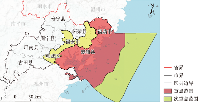
科学合理地确定海岸带空间范围,是开展海岸带空间规划的重要前提,空间范围界定模糊或不合理,将直接影响规划的科学性和管理的有效性。海岸带之所以具有特殊性,其根本原因在于陆域、海域之间存在跨系统影响。由于未能充分考虑跨系统影响的重要作用,以往海岸带空间范围划定方法的科学性和合理性有待商榷,以生态系统为基础的陆海统筹研究进展缓慢。据此,在陆海跨系统影响的视角下,本文首先比较了海岸带不同空间范围界定方法的优缺点及适用要素。然后,通过跨系统影响的类型、过程和范围的分析,提出了行政边界、自然地理标示、空间距离等多种方法相结合的海岸带空间范围界定方法。最后,以福建省宁德市为研究案例进行了海岸带空间范围划定方法的应用展示。方法所界定的空间范围能够基本涵盖海岸带生态系统,反映跨系统影响的真实状况,为建立跨系统影响为核心要素的陆海统筹及海岸带空间规划提供了理论依据与技术指导。
刘健枭 , 文超祥 . 基于陆海跨系统影响视角的海岸带空间范围划定研究——以宁德市为例[J]. 地理研究, 2024 , 43(1) : 236 -254 . DOI: 10.11821/dlyj020220842
To effectively conduct coastal spatial planning, it is imperative to scientifically and rationally determine the spatial extent of coastal zones. The precision in demarcating these boundaries is not just a procedural formality but a fundamental necessity that directly impacts the scientific rigor and operational effectiveness of coastal spatial planning efforts. The unique character of coastal zones is intrinsically tied to the cross-system interactions between terrestrial and marine ecosystems. Traditional approaches to delineate these zones have often fallen short in scientific validity and practical rationality, primarily due to their limited acknowledgment of these critical cross-system dynamics. Consequently, the advancement of ecosystem-based integrated land-sea research has been notably slow. Recognizing this deficiency, this study embarks on a comparative analysis of various methods employed to define coastal spatial boundaries, weighing their strengths and weaknesses against the backdrop of land-sea cross-system influences. The analysis delves into the types, processes, and scope of these influences, thereby laying the groundwork for a more comprehensive method of demarcation. The proposed methodology integrates diverse approaches, incorporating administrative boundaries, natural geographic landmarks, and spatial distances. This multifaceted approach aims to encapsulate the complexity of coastal zones more accurately, aligning administrative convenience with ecological realities. The city of Ningde in Fujian province serves as an illustrative case study to showcase the application of the proposed method. The spatial boundaries delineated using our proposed method successfully encompass the coastal ecosystems, capturing the nuances of cross-system interactions. This alignment of ecological and administrative boundaries is crucial for effective coastal management and spatial planning. By accurately reflecting the interplay of terrestrial and marine ecosystems, the delineated boundaries provide a more realistic portrayal of coastal dynamics, which is vital for crafting sustainable and effective coastal management strategies. Furthermore, the study's findings contribute significantly to the theory and practice of integrated land and sea planning. By centering on cross-system impacts, the proposed method offers not just a theoretical framework but also practical guidance for coastal spatial planning. This approach is poised to facilitate more informed decision-making, ensuring that management strategies and planning initiatives are grounded in a comprehensive understanding of the complex, intertwined nature of coastal ecosystems.
表1 海岸带空间范围的主要划定方法及其特点Tab. 1 The main methods of delineating the spatial scope of the coastal zone and their characteristics |
| 方法 | 定义 | 陆域一侧 | 海域一侧 | 优点 | 缺点 |
|---|---|---|---|---|---|
| 行政边界 | 利用现行的省、市、县行政区划界限 | 行政区域边界 | 行政区域边界 | 有利规划实施,具有较好的稳定性 | 忽视了跨系统影响和生态连续性;生态过程难保持一致 |
| 空间距离 | 以岸线为基准,向陆海两侧扩展一定距离 | 一定距离 | 一定距离 | 易于理解和操作 | 易与地理特征冲突;确定距离的参考要素缺乏生态考量 |
| 自然标示 | 具有明显地理学特征的物理标示 | 地形、河流等 | 等深线、大陆架边缘等 | 具有一定的地理和生态学意义 | 对于具体自然标志的选择欠缺合理依据 |
| 环境单元 | 具有相对独立且完整的生态连续性的区域 | 集水区等 | 自然要素相似海域 | 区域内生态属性的同质性较高 | 海域部分环境单元的界定较为困难 |
| 综合方式 | 根据研究区特点,综合多种方法进行划分 | 据研究、管理需要设定 | 据研究、管理需要设定 | 具有兼容生态、社会、经济空间潜力 | 多种划分方法之间如何进行合理组合还存在难点 |
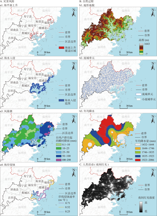
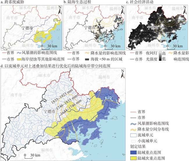
表2 宁德市陆域一侧海岸带空间范围划定的影响要素Tab. 2 Influencing elements in the delineation of the spatial scope of coastal zone on the land side of Ningde city |
| 类别 | 要素 | 关键参数设置 | 数据及资料来源 |
|---|---|---|---|
| 陆海跨系统威胁 | 海平面上升 | 以上升1m进行计算 | Climate Central(https://www.climatecentral.org/) |
| 风暴潮 | 核心区:纳入近岸100~250mm以及50~100mm的大暴雨及暴雨区。 次核心区:纳入近岸50~100mm、25~50mm、10~25mm的暴雨、大雨及中雨覆盖区域。 | 林珺[26] | |
| 海水入侵 | 福建的海水入侵范围一般小于4km | 自然资源部[27] | |
| 海岸侵蚀 | 霞浦县0.71m/年;蕉城区0.51m/年;福鼎0.53m/年;福安0.25m/年;以100年进行计算 | 朱正涛[28] | |
| 陆海生态过程 | 地形地势 | 纳入海拔低于50m近岸区域[29,30] | ALOS-12m(分辨率12.5m)(https://www.resdc. cn/data.aspx?DATAID=337) |
| 集水区单元 | GIS水文分析 | ||
| 年均降水量 | 纳入年降水量小于1835mm的近海区域 | Zhang S等[31] | |
| 陆海经济社会活动 | 乡镇行政边界 | — | 中国科学院资源环境数据中心(https://www.resdc.cn/) |
| 人口聚集区域 | 纳入夜间灯光数据DN值大于80的近岸区域 | 中国科学院“火石”(Flint),2017年夜间灯光数据(分辨率500m)(https://pixelknife.github.io/product/product_flint.html) |
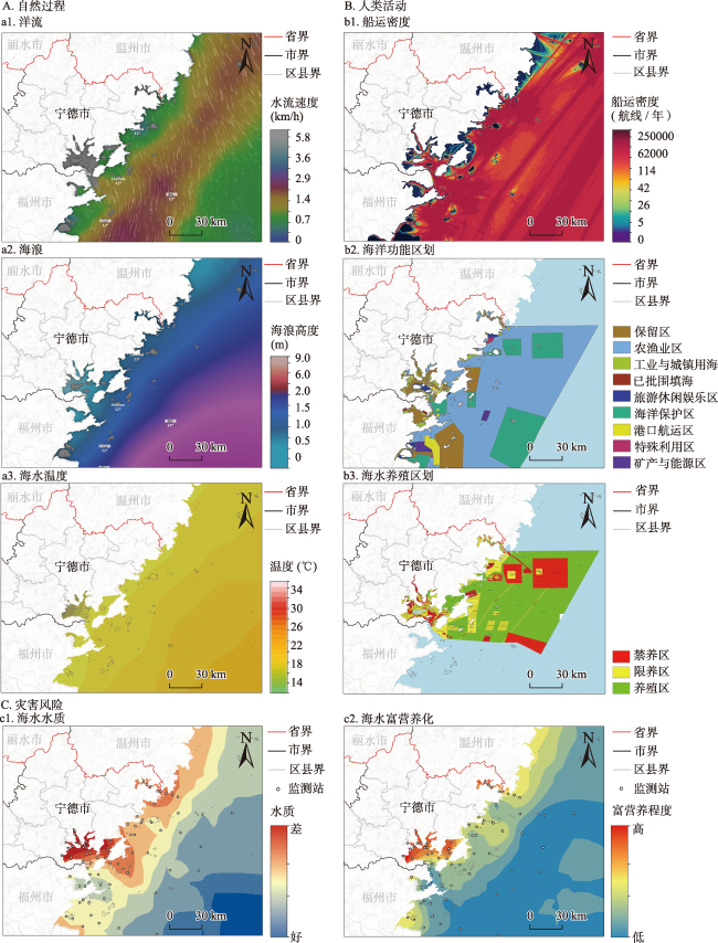
表3 宁德市海域一侧海岸带空间范围划定的影响要素Tab. 3 Influencing elements of the delineation of the spatial scope of the coastal zone on the sea side of Ningde city |
| 类别 | 要素 | 关键参数设置 | 数据及资料来源 |
|---|---|---|---|
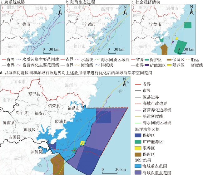
| 陆海跨系 统威胁 | 近岸水质状态 | 纳入近海受污染的水质区域:三类、四类、劣四类 | 基于2020年秋季宁德和福州市104个海洋环境监测点位数据绘制;数据来源福建省生态厅(https://sthjt.fujian.gov.cn/)(站点分布见图4c1~图4c2) |
| 富营养化状态 | 以营养指数法计算[33];纳入富营养化严重、重度、中度、轻度的近海区域 | ||
| 陆海生态 过程 | 水温 | 纳入海水温度<18℃的近海区域 | 截取2022/01/17 14:00时海水温度数据 (https://www.wunderground.com/) |
| 洋流 | 纳入洋流速度<1.4 km/h的近海区域 | 截取2022/01/18 13:00时洋流状态数据 (https://www.windy.com/) | |
| 海浪 | 纳入海浪高度<1.5 m的近海区域 | 截取2022/01/20 10:00时海浪状态数据 (https://www.windy.com/) | |
| 陆海经济 社会活动 | 养殖区域 | 以近海养殖功能区对划定边界进行优化 | 宁德市人民政府[34] |
| 海洋使用用途 | 以海洋功能区划对划定边界进行优化 | 中华人民共和国国务院[35] | |
| 船运轨迹密度 | 近海船运密度>62000条/(0.3km2·年) | 单位面积内每年经过的船只(2022年1月基于Marine Traffic进行的数据截取, https://www.marinetraffic.com) |
图4 宁德市海洋一侧跨系统影响要素的空间量化分析结果注:图中海岸线依据文献[32]的研究成果绘制。 Fig. 4 Spatial analysis of cross-system impact elements on the sea side of Ningde city |
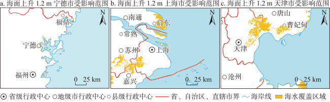
图7 相同空间尺度下海平面上升对不同城市的影响程度对比注:该图基于自然资源部地图技术审查中心标准地图(审图号:GS(2023)2764号)绘制,地图边界无修改;海平 面上升1.2m数据基于Climate Central (https://www.climatecentral.org/)平台绘制。 Fig. 7 Comparison of the extent of sea level rise impacts on different cities at the same spatial scale |
| [1] |
中共中央、国务院. 中共中央国务院关于建立更加有效的区域协调发展新机制的意见. https://www.gov.cn/zhengce/2018-11/29/content_5344537.htm, 2023-11-27.
[Central Committee of the Communist Party of China, State Council. Opinions of the central committee of the communist party of China and the state council on establishing a new mechanism for more effective coordinated regional development. https://www.gov.cn/zhengce/2018-11/29/content_5344537.htm, 2023-11-27.]
|
| [2] |
|
| [3] |
Sas, Eliraz,
|
| [4] |
|
| [5] |
Crean, Kevin. The influence of boundaries on the management of fisheries resources in the European Union: Case studies from the UK. Geoforum, 2000, 31(3): 315-328. DOI: 10.1016/S0016-7185(00)00003-8.
|
| [6] |
文超祥, 阙权鸿, 林小如. 基于海湾单元的陆海统筹空间规划研究. 城市发展研究, 2022, 29(1): 27-34.
[
|
| [7] |
文超祥, 刘健枭. 基于陆海统筹的海岸带空间规划研究综述与展望. 规划师, 2019, 35(7): 5-11.
[
|
| [8] |
广东省人民政府、国家海洋局. 广东省人民政府国家海洋局关于印发广东省海岸带综合保护与利用总体规划的通知. https://www.gd.gov.cn/gkmlpt/content/0/146/post_146486.html#7, 2023-11-27.
[People's Government of Guangdong Province, State Oceanic Administration. Notice of the people's government of Guangdong province of the state oceanic administration on the issuance of the master plan for the comprehensive protection and utilization of the coastal belt of Guangdong province. https://www.gd.gov.cn/gkmlpt/content/0/146/post_146486.html#7, 2023-11-27.]
|
| [9] |
福建省第十二届人民代表大会常务委员会. 福建省海岸带保护与利用管理条. http://www.fjrd.gov.cn/ct/63-126714, 2023-11-27.
[Standing Committee of the Twelfth People's Congress of Fujian Province. Regulations on the protection and utilization of coastal zone in Fujian province. http://www.fjrd.gov.cn/ct/63-126714, 2023-11-27. ]
|
| [10] |
|
| [11] |
青岛市第十一届人民代表大会常务委员会. 青岛市海岸带规划管理规定. https://www.chinacourt.org/law/detail/1995/05/id/61552.shtml, 2023-11-27.
[The Standing Committee of the Eleventh Qingdao Municipal People's Congress. Qingdao coastal zone planning and management regulations. https://www.chinacourt.org/law/detail/1995/05/id/61552.shtml, 2023-11-27.]
|
| [12] |
|
| [13] |
Millennium Ecosystem Assessment. Ecosystems and Human Well-Being:A Framework for Assessment. Washington, DC: Island Press, 2003: 1-100.
|
| [14] |
|
| [15] |
深圳市规划和国土资源委员会(市海洋局). 市规划国土委关于印发《深圳市海洋环境保护规划(2018-2035年)》的通知. https://pnr.sz.gov.cn/xxgk/ghjh/content/post_5842077.html, 2023-11-27.
[Shenzhen Municipal Planning and Land Resources Commission (Municipal Oceanic Bureau). Notice of the municipal planning and land resources commission on the issuance of Shenzhen Marine Environmental Protection Plan (2018-2035). https://pnr.sz.gov.cn/xxgk/ghjh/content/post_5842077.html, 2023-11-27.]
|
| [16] |
|
| [17] |
张璐. 气候变化带来海洋变暖和酸化问题,哪些海洋生物会受到威胁? https://baijiahao.baidu.com/s?id=1709134246799415636&wfr=spider&for=pc, 2023-11-27.
[
|
| [18] |
|
| [19] |
|
| [20] |
吕为群, 袁明哲. 温度变化对鱼类行为影响的研究进展. 上海海洋大学学报, 2017, 26(6): 828-835.
[
|
| [21] |
|
| [22] |
|
| [23] |
|
| [24] |
|
| [25] |
|
| [26] |
林珺. 9号台风“卢碧”生成!今天我市部分有暴雨或大暴雨. http://cmstop.ndsww.com/p/63547.html, 2023-11-27.
[
|
| [27] |
自然资源部. 2018年中国海洋灾害公报. http://gi.mnr.gov.cn/201905/t20190510_2411197.html, 2023-11-27.
[Ministry of Natural Resources. China marine hazards bulletin 2018. http://gi.mnr.gov.cn/201905/t20190510_2411197.html, 2023-11-27.]
|
| [28] |
朱正涛. 海岸侵蚀脆弱性评估模型构建及其应用研究. 上海: 华东师范大学博士学位论文, 2019: 68.
[
|
| [29] |
侯西勇, 徐新良. 21世纪初中国海岸带土地利用空间格局特征. 地理研究, 2011, 30(8): 1370-1379.
[
|
| [30] |
江娜, 陈超, 韩海丰. 海岸带地类统计模型中DEM空间尺度优选方法. 自然资源遥感, 2022, 34(1): 34-42.
[
|
| [31] |
|
| [32] |
李加林, 田鹏, 邵姝遥, 等. 中国东海区大陆海岸线数据集(1990-2015). 全球变化数据学报(中英文), 2019, 3(3): 252-258+362-368.
[
|
| [33] |
谢宏英. 赤潮灾害风险评估研究. 上海: 上海海洋大学博士学位论文, 2018: 28.
[
|
| [34] |
宁德市人民政府. 宁德市人民政府关于印发宁德市海水养殖水域滩涂规划(2018—2030年)(修编)的通知. http://ningde.gov.cn/zwgk/tzgg/zfbmtzgg/202209/t20220913_1659336.htm, 2023-11-27.
[People's Government of Ningde City. Notice of the people's government of Ningde city on the issuance of the Ningde city marine aquaculture waters and mudflats plan (2018-2030) (Revised). http://ningde.gov.cn/zwgk/tzgg/zfbmtzgg/202209/t20220913_1659336.htm, 2023-11-27.]
|
| [35] |
中华人民共和国国务院. 国务院关于福建省海洋功能区划(2011—2020年)的批复. https://www.gov.cn/gongbao/content/2012/content_2251651.htm, 2023-11-27.
[State Council of the People's Republic of China. Reply of the state council on the approval of the marine functional zoning of Fujian province (2011-2020). https://www.gov.cn/gongbao/content/2012/content_2251651.htm, 2023-11-27.]
|
| [36] |
王中建. 省级海岸带综合保护与利用规划编制启动. https://www.mnr.gov.cn/dt/ywbb/202109/t20210915_2680701.html, 2023-11-27.
[
|
| [37] |
|
| [38] |
|
| [39] |
|
| [40] |
|
/
| 〈 |
|
〉 |