
多源径流数据在中国不同流域的比较研究
|
潘扎荣(1985-),男,福建南平人,博士,高级工程师,主要研究方向为水文与水资源。E-mail: panzharong@giwp.org.cn |
收稿日期: 2023-08-04
录用日期: 2023-12-12
网络出版日期: 2024-04-12
基金资助
国家自然科学基金项目(52209040)
中国科协青年人才托举工程(YESS20220331)
中国博士后科学基金(2022M713119)
Comparing multi-source runoff data in different watersheds across China
Received date: 2023-08-04
Accepted date: 2023-12-12
Online published: 2024-04-12
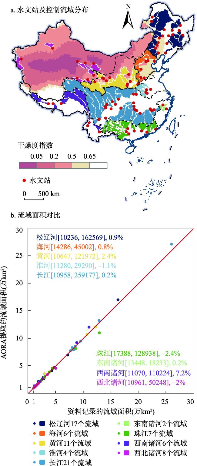
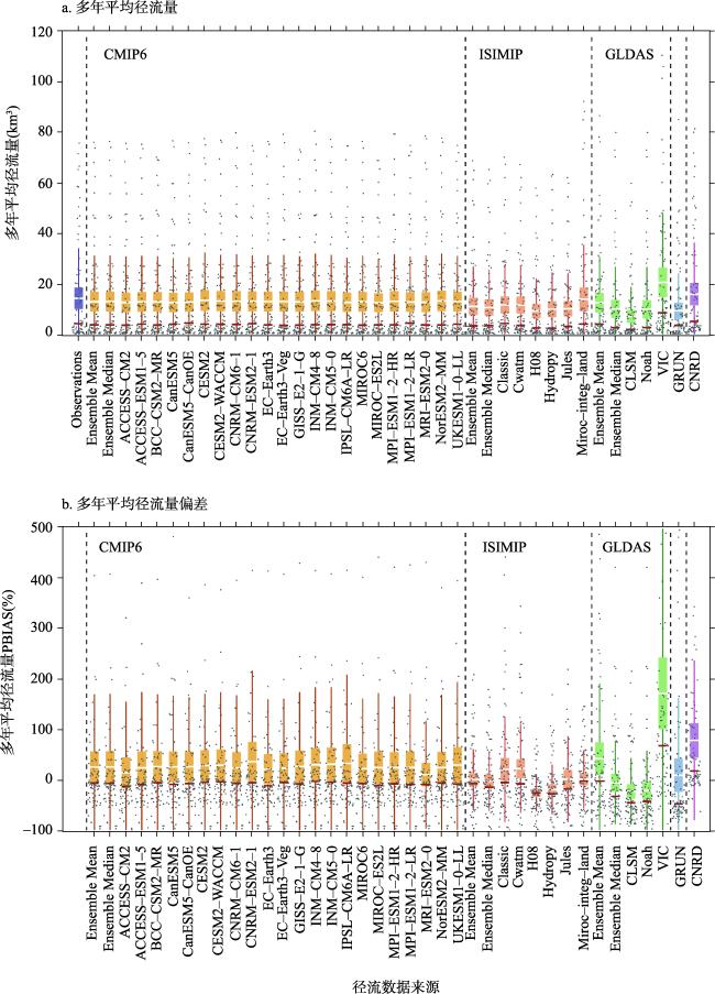
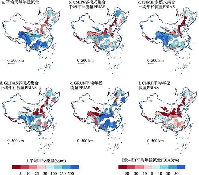
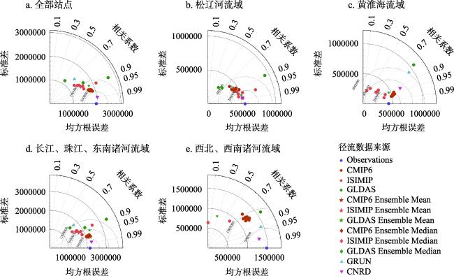
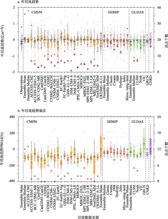
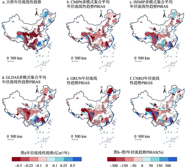
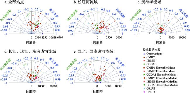
多源径流数据是理解地表水资源分布格局和演变规律的基础,径流数据的比较和筛选是其应用和推广的前提,但中国范围内的径流数据比较研究仍相对缺乏。本研究在中国九大流域片,选取控制范围不重叠、1961—2014年天然径流资料连续的82个水文站,从多年平均径流量和径流变化趋势两个方面,评价了CMIP6地球系统模式、ISIMIP3a全球水文模型、基于陆面模型的GLDAS和CNRD、基于机器学习的GRUN等四类33套径流数据集的质量。研究表明:① 百分比偏差的评价结果显示,经过偏差校正的CMIP6、ISIMIP3a、GLDAS、GRUN、CNRD均能较好模拟大部分流域的平均径流;综合标准差、均方根误差、皮尔逊相关系数3个评价角度的泰勒图分析结果显示,CNRD在松辽河流域,长江、珠江、东南诸河流域,西北、西南诸河流域表现最优,偏差校正后的CMIP6和GLDAS多模型平均结果在黄淮海流域表现最优。② 多源径流数据对多年平均径流量的模拟普遍较好,而对年径流变化趋势的模拟结果较差,特别是CMIP6和GRUN严重低估了径流趋势,约10个流域的趋势模拟结果与天然径流资料的趋势相反。③ 多源径流数据在相对干旱区域模拟结果较差,亟需提高驱动数据质量、改进模型结构、优化模型参数,以提升模型对干旱区水循环过程模拟的精度。这项工作为研究中国河川径流及地表水资源时空演变规律,提供了数据筛选的重要依据,为多源径流数据在中国不同流域的更新与发展,明确了可能的问题和改进方向。
潘扎荣 , 王恺文 , 盛志刚 , 徐翔宇 , 周演腾 , 王冠 , 田巍 . 多源径流数据在中国不同流域的比较研究[J]. 地理研究, 2024 , 43(4) : 1004 -1017 . DOI: 10.11821/dlyj020230652
The multi-source runoff data serve as a foundation for comprehending the spatial pattern and temporal evolution of surface water resources. Comparing and screening runoff data are prerequisites for their effective application and widespread adoption. However, comparing multi-source runoff data in China remains a gap. To address this, here, we collect continuous natural streamflow data from 82 hydrological stations covering the period of 1961-2014. These stations are situated in nine major river basins across China, each with distinct non-overlapping control areas. We utilize natural streamflow data as the benchmark to compare 33 data sets from four categories, i.e., data from earth system models in CMIP6, global hydrology models in ISIMIP3a, land surface models in GLDAS and CNRD, and machine learning results from GRUN, in terms of the multi-year mean streamflow and annual streamflow trend. The results indicate that: (1) PBIAS shows that the bias-corrected CMIP6, ISIMIP3a, GLDAS, GRUN, and CNRD can grasp the mean streamflow in most watersheds, and the Taylor diagram analysis integrating standard deviation, root mean square error, and Pearson correlation coefficient shows that CNRD performs best in the Songliao River Basin, Yangtze River Basin, Pearl River Basin, Southeast river basins, and Northwest and Southwest river basins, while the bias-corrected CMIP6 and ISIMIP3a multi-model ensemble mean show excellent simulation in Huang-Huai-Hai River Basin. (2) The multi-source runoff data exhibit accurate representation of the annual mean natural streamflow, while the simulation results for trends are not satisfactory, particularly for CMIP6 and GRUN, as they significantly underestimate the runoff trends in approximately 10 watersheds, resulting in opposite trends compared to the reference data. (3) The simulation also performs poorly in relatively arid regions, highlighting the urgent necessity to enhance the quality of the driving data, refine the model structure, and optimize model parameters to improve the accuracy of the model in simulating the water cycle process in arid regions. This work provides an important basis for data screening to study the spatial and temporal evolution of streamflow and surface water resources in China, and clarifies the possible problems and measures for the updating and development of multi-source runoff data in different watersheds across China.
表1 多源径流数据信息Tab. 1 Information on multi-source runoff data |
| 数据来源 | 模型名称 | 分辨率 | 模型名称 | 分辨率 | 模型名称 | 分辨率 | 模型名称 | 分辨率 |
|---|---|---|---|---|---|---|---|---|
| CMIP6 | ACCESS-CM2 | 1.3o×1.9o | ACCESS-ESM1-5 | 1.2o×1.9o | BCC-CSM2-MR | 1.1o×1.1o | CanESM5 | 2.8o×2.8o |
| CanESM5-CanOE | 2.8o×2.8o | CESM2 | 0.9o×1.3o | CESM2-WACCM | 0.9o×1.3o | CNRM-CM6-1 | 1.4o×1.4o | |
| CNRM-ESM2-1 | 1.4o×1.4o | EC-Earth3 | 0.7o×0.7o | EC-Earth3-Veg | 0.7o×0.7o | GISS-E2-1-G | 2.0o×2.5o | |
| INM-CM4-8 | 1.5o×2.0o | INM-CM5-0 | 1.5o×2.0o | IPSL-CM6A-LR | 1.3o×2.5o | MIROC6 | 1.4o×1.4o | |
| MIROC-ES2L | 2.8o×2.8o | MPI-ESM1-2-HR | 0.9o×0.9o | MPI-ESM1-2-LR | 2.0o×2.0o | MRI-ESM2-0 | 1.1o×1.1o | |
| NorESM2-MM | 0.9o×1.3o | UKESM1-0-LL | 1.3o×1.9o | |||||
| ISIMIP | Classic | 0.5o×0.5o | Cwatm | 0.5o×0.5o | H08 | 0.5o×0.5o | Hydropy | 0.5o×0.5o |
| Jules | 0.5o×0.5o | Miroc-integ-land | 0.5o×0.5o | |||||
| GLDAS | CLSM | 1.0o×1.0o | Noah | 1.0o×1.0o | VIC | 1.0o×1.0o | ||
| GRUN | Random Forest | 0.5o×0.5o | ||||||
| CNRD | VIC | 0.3o×0.3o |
真诚感谢匿名评审专家在论文评审中所付出的时间和精力,专家对本文研究方法、结果分析、讨论与结论梳理方面的修改意见,使本文获益匪浅。
| [1] |
张建云, 王国庆, 金君良, 等. 1956—2018年中国江河径流演变及其变化特征. 水科学进展, 2020, 31(2): 153-161.
[
|
| [2] |
王浩, 王建华. 中国水资源与可持续发展. 中国科学院院刊, 2012, 27(3): 352-358, 331.
[
|
| [3] |
李原园, 李云玲, 何君. 新发展阶段中国水资源安全保障战略对策. 水利学报, 2021, 52(11): 1340-1346, 1354.
[
|
| [4] |
严登华, 任立良, 王国庆, 等. 关于陆地水循环演变及其在全球变化中的作用研究设想. 水科学进展, 2016, 27(6): 935-942.
[
|
| [5] |
王开存, 王灿, 李龙辉, 等. 全球变化驱动下陆表自然和人文要素相互作用及区域表现. 中国基础科学, 2017, 19(5): 23-28.
[
|
| [6] |
杨大文, 徐宗学, 李哲, 等. 水文学研究进展与展望. 地理科学进展, 2018, 37(1): 36-45.
[
|
| [7] |
|
| [8] |
|
| [9] |
|
| [10] |
|
| [11] |
|
| [12] |
|
| [13] |
|
| [14] |
倪宁淇, 谢佳鑫, 刘小莽, 等. 基于径流对气候变化敏感性指标的多源数据质量评估. 地理学报, 2022, 77(9): 2280-2291.
[
|
| [15] |
|
| [16] |
于海鹏. 基于GLDAS的全球干燥度指数数据集(1948—2018). 国家青藏高原科学数据中心. https://doi.org/10.11888/Atmos.tpdc.271832.
[
|
| [17] |
|
| [18] |
|
| [19] |
|
| [20] |
|
| [21] |
|
| [22] |
|
| [23] |
|
| [24] |
|
| [25] |
|
| [26] |
|
| [27] |
杨大文, 张树磊, 徐翔宇. 基于水热耦合平衡方程的黄河流域径流变化归因分析. 中国科学: 技术科学, 2015, 45(10): 1024-1034.
[
|
| [28] |
刘剑宇, 张强, 陈喜, 等. 气候变化和人类活动对中国地表水文过程影响定量研究. 地理学报, 2016, 71(11): 1875-1885.
[
|
| [29] |
|
| [30] |
|
| [31] |
|
/
| 〈 |
|
〉 |