
青海高原温性草原对气候变化和人类活动响应动态机制研究
|
俞文政(1974-),男,江苏南京人,博士,教授,硕士生导师,主要研究方向为气候变化及其响应、区域可持续发展。E-mail: ywzheng519@126.com |
收稿日期: 2024-03-18
录用日期: 2024-05-30
网络出版日期: 2024-08-09
基金资助
国家自然科学基金重点项目(U20A2098)
Dynamic response mechanisms of temperate steppe to climate change and human activities on the Qinghai Plateau
Received date: 2024-03-18
Accepted date: 2024-05-30
Online published: 2024-08-09
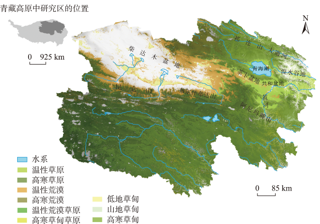
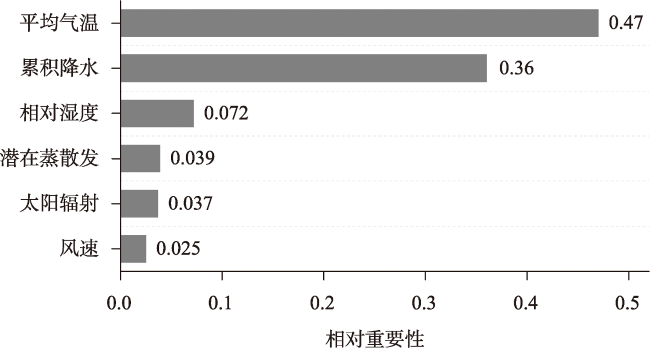
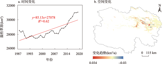
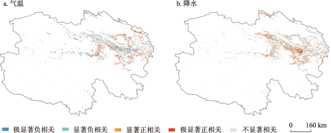
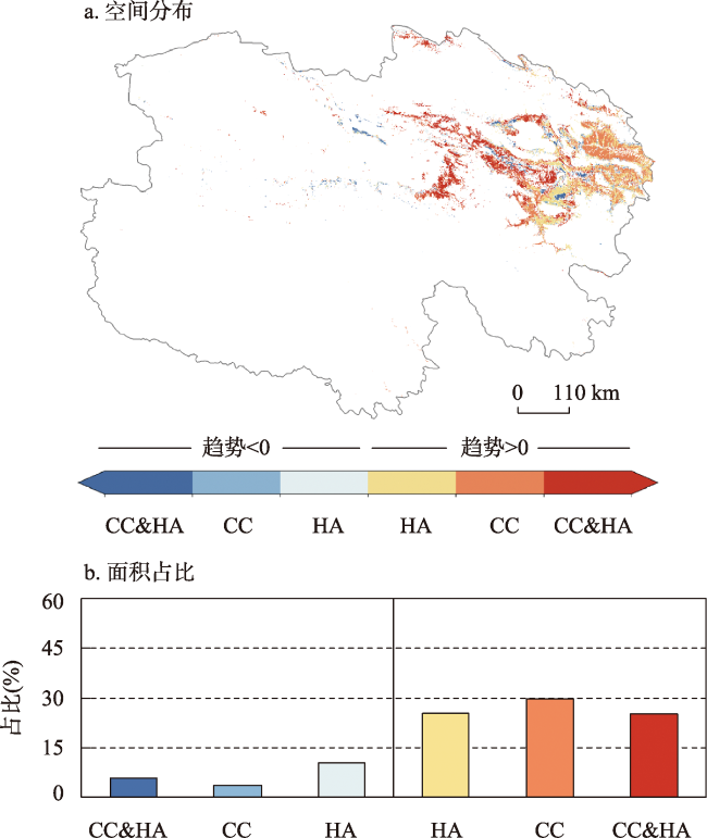
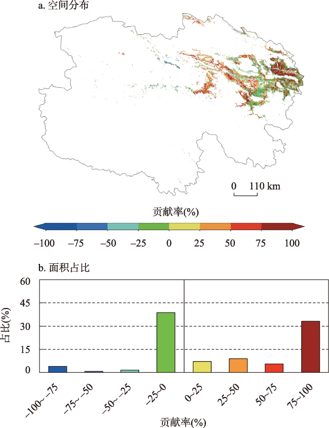
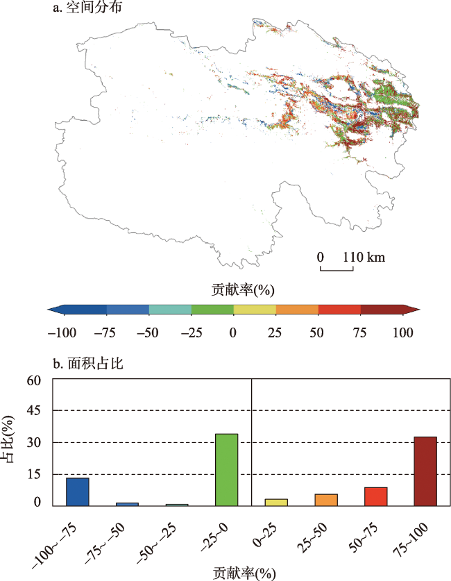
温性草原作为维护青海高原草畜平衡和生态安全的重点区域,对气候变化和人类活动极为敏感。本文依托GEE平台构建长时序、高精度的草地类型数据,结合气候数据,引入随机森林模拟气候因素与温性草原间的非线性关系,对传统残差分析进行改进,以此探究青海高原温性草原的时空演变及其驱动因素。结果表明:① 1987—2020年青海高原温性草原面积呈显著增长趋势,主要上升区域为共和盆地、茶卡盆地、柴达木盆地东侧等,下降区域仅占21.4%。② 青海高原温性草原面积与气温和降水间呈正相关的区域占比为58.1%和67.3%,其中显著相关区域均在15%以上,可见气候的暖湿化对温性草原面积增加具有促进作用。③ 青海高原温性草原面积增加主要受气候变化与人类活动的共同影响,其中气候变化和人类活动相对贡献超过75%的区域分别占比33.1%和32.6%,集中于研究区东部和南部;而温性草原面积减少的主导因子为人类活动,主要分布于黄河流域,青海湖沿岸的部分区域。青海高原温性草原的时空变化及其驱动因素的定量研究结果可为草地可持续发展和政策制定提供支撑。
俞文政 , 周雅文 , 魏柱灯 , 姚鑫 , 张玉冰 . 青海高原温性草原对气候变化和人类活动响应动态机制研究[J]. 地理研究, 2024 , 43(8) : 1941 -1957 . DOI: 10.11821/dlyj020240223
Temperate steppe is a crucial area for maintaining the balance between grassland and livestock and ensuring ecological security on the Qinghai Plateau. It is highly sensitive to both climate change and human activities. This study constructs long-term, high-resolution grassland type data using the Google Earth Engine (GEE) platform and integrates climate data. By introducing random forest modeling to simulate the nonlinear relationship between climate factors and temperate steppe, we improve traditional residual analysis and explore the spatiotemporal evolution and driving factors of temperate steppe on the Qinghai Plateau. The results indicate that: (1) From 1987 to 2020, the temperate steppe area on the Qinghai Plateau exhibited a significant increasing trend, particularly in regions such as the Gonghe Basin, Chaka Basin, and the eastern side of the Qaidam Basin, with only 21.4% showing a decrease. (2) The proportion of areas on the Qinghai Plateau with a positive correlation of temperature and precipitation were 58.1% and 67.3%, respectively, with significant correlation areas exceeding 15%. This indicates that warmer and wetter climate conditions facilitate an increase in grassland area. (3) The increase in temperate steppe area is mainly influenced by climate change and human activities, with regions where these factors contribute over 75% covering 33.1% and 32.6%, respectively, concentrated in the eastern and southern parts of the study area. Conversely, human activities predominantly drive the decrease in grassland area, mainly in the Yellow River Basin and some areas around the Qinghai Lake. This quantitative research on the spatiotemporal changes and driving factors of temperate steppe on the Qinghai Plateau provides support for sustainable grassland development and policy formulation.
Key words: temperate steppe; driving factors; random forest; residual analysis; Qinghai Plateau
表1 特征指标体系Tab. 1 Feature index system |
| 分类 | 特征参量 |
|---|---|
| 植被生物物理、生化和 生理特性信息 | NDVI、Chlorophyll Index Green、Green leaf index、Leaf Water Content Index等32个光谱指数 |
| 土壤信息 | 土壤类型、湿度、pH值、有机碳含量 |
| 地物光谱波段信息 | 红、绿、蓝、近红外、短波红外、热红外 |
| 地形地貌 | 经度、纬度、海拔、坡度、坡向、多尺度地形位置指数和多尺度地形多样性指数等 |
| 地表纹理 | Gray-Level Co-Occurrence Matrix (GLCM) Textural (Correlation and Contrast) |
| 地表时相差异 | Multitemporal Kauth-Thomas (MKT) |
表2 驱动因子判定标准及贡献率计算方法Tab. 2 Driving factor and contribution rate calculation methods |
| Slope(AreaACT) | 驱动因子 | 驱动因子判定标准 | 相对贡献率 | |||
|---|---|---|---|---|---|---|
| Slope(AreaCC) | Slope(AreaHA) | 气候变化 | 人类活动 | |||
| >0 | CC&HA | >0 | >0 | Slope(AreaCC)/Slope(AreaACT) | Slope(AreaHA)/Slope(AreaACT) | |
| CC | >0 | <0 | 100 | 0 | ||
| HA | <0 | >0 | 0 | 100 | ||
| <0 | CC&HA | <0 | <0 | Slope(AreaCC)/Slope(AreaACT) | Slope(AreaHA)/Slope(AreaACT) | |
| CC | <0 | >0 | 100 | 0 | ||
| HA | >0 | <0 | 0 | 100 | ||
注:CC为气候变化;HA为人类活动。 |
表3 草地类型分类精度Tab. 3 Accuracy of grassland type classification |
| 草地类型 | 生产者精度(PA) | 用户精度(UA) | Kappa | 总体准确率(OA) |
|---|---|---|---|---|
| 温性草原 | 0.89 | 0.87 | 0.82 | 0.86 |
| 温性荒漠草原 | 0.98 | 0.99 | ||
| 高寒草甸草原 | 0.72 | 0.81 | ||
| 高寒草原 | 0.83 | 0.83 | ||
| 温性荒漠 | 0.92 | 0.90 | ||
| 高寒荒漠 | 0.89 | 0.94 | ||
| 低地草甸 | 0.87 | 0.93 | ||
| 山地草甸 | 0.81 | 0.87 | ||
| 高寒草甸 | 0.82 | 0.80 |
图6 1987—2020年气候变化对温性草原变化的贡献率空间分布及面积占比Fig. 6 Spatial distribution and proportion of area of contribution of climatic change to temperate steppe change on the Qinghai Plateau from 1987 to 2020 |
真诚感谢匿名审稿人在论文评审中所付出的时间和精力,专家对本文创新性的提升、研究思路的完善、文章题目的确定、行文逻辑的梳理、内容凝练等方面提出的专业意见,使本文受益匪浅。
| [1] |
|
| [2] |
辛玉春. 青海省温性草原类草地的分布特征. 青海草业, 2014, 23(1): 35-42.
[
|
| [3] |
|
| [4] |
魏晓旭, 魏伟, 刘春芳. 近40年青海省草地植被时空变化及其与人类活动的关系. 生态学杂志, 2021, 40(8): 2541-2552.
[
|
| [5] |
戴雪, 余钟波. 藏东高原-藏东南高山峡谷过渡区多角度生态系统综合评估: 以西藏昌都为例. 地理研究, 2023, 42(7): 1971-1984.
[
|
| [6] |
孙锐, 陈少辉, 苏红波. 黄土高原不同生态类型NDVI时空变化及其对气候变化响应. 地理研究, 2020, 39(5): 1200-1214.
[
|
| [7] |
|
| [8] |
|
| [9] |
|
| [10] |
郑德凤, 郝帅, 吕乐婷, 等. 三江源国家公园生态系统服务时空变化及权衡-协同关系. 地理研究, 2020, 39(1): 64-78.
[
|
| [11] |
|
| [12] |
|
| [13] |
|
| [14] |
|
| [15] |
|
| [16] |
|
| [17] |
|
| [18] |
|
| [19] |
|
| [20] |
武爽, 冯险峰, 孔玲玲, 等. 气候变化及人为干扰对西藏地区草地退化的影响研究. 地理研究, 2021, 40(5): 1265-1279.
[
|
| [21] |
|
| [22] |
|
| [23] |
|
| [24] |
向明学, 郭应杰, 古桑群宗, 等. 不同放牧强度对拉萨河谷温性草原植物群落和物种多样性的影响. 草地学报, 2019, 27(3): 668-674.
[
|
| [25] |
|
| [26] |
|
| [27] |
彭守璋. 中国1km 分辨率逐月降水量数据集(1901—202). 国家青藏高原科学数据中心, 2020.
[
|
| [28] |
|
| [29] |
|
| [30] |
|
| [31] |
|
| [32] |
|
| [33] |
|
| [34] |
|
| [35] |
|
| [36] |
|
| [37] |
|
| [38] |
|
| [39] |
|
| [40] |
|
| [41] |
|
| [42] |
|
| [43] |
|
| [44] |
|
| [45] |
|
| [46] |
王亚晖, 唐文家, 李森, 等. 青海省草地生产力变化及其驱动因素. 草业学报, 2022, 31(2): 1-13.
[
|
| [47] |
夏翠珍, 周立华, 裴孝东, 等. 三江源国家公园区政府和牧民二元视角下的退牧还草工程绩效研究. 自然资源学报, 2023, 38(6): 1570-1587.
[
|
| [48] |
赵苗苗, 赵海凤, 李仁强, 等. 青海省1998—2012年草地生态系统服务功能价值评估. 自然资源学报, 2017, 32(3): 418-433.
[
|
| [49] |
|
| [50] |
邵全琴, 樊江文, 刘纪远, 等. 基于目标的三江源生态保护和建设一期工程生态成效评估及政策建议. 中国科学院院刊, 2017, 32(1): 35-44.
[
|
| [51] |
|
| [52] |
|
| [53] |
|
| [54] |
|
| [55] |
|
| [56] |
|
| [57] |
|
| [58] |
|
| [59] |
|
| [60] |
肖晔, 赵林, 乔路明, 等. 京津冀文化艺术产业空间格局演变及其影响因素. 地理研究, 2021, 40(6): 1768-1784.
[
|
| [61] |
|
| [62] |
张文强, 罗格平, 郑宏伟, 等. 基于随机森林模型的内陆干旱区植被指数变化与驱动力分析: 以北天山北坡中段为例. 植物生态学报, 2020, 44(11): 1113-1126.
[
|
/
| 〈 |
|
〉 |