

1 引言
在20世纪中期就有大量学者对国内外著名的古梯田展开了研究,如国内著名的云南哈尼梯田、广西龙脊梯田、湖南紫鹊界梯田,国外菲律宾伊富高梯田和巴厘岛梯田等。这些研究总体上围绕“梯田空间格局与生态系统”[6⇓⇓⇓⇓⇓-12]、“梯田农耕文化遗产”[13⇓⇓-16]、“梯田景观旅游及可持续发展”[17⇓⇓⇓-21]等主题展开。针对梯田土地性质的研究,多关注大尺度、典型区域梯田土地信息提取[22]、空间分布格局[23]、土地利用/覆被动态变化[24,25]及驱动因素[26]等方面展开。但基于小尺度山区梯田土地利用时空演化的过程,探究山区梯田生态系统中的多种人地关系同山区乡村发展的研究仍不够系统深入,需要深度挖掘。
世界各地的土地利用变化趋势总体上是由生计农业及小农用地向规模化的集约农业用地转型[27]。受社会发展、劳动移民等因素驱动,中国的农业土地利用变化存在着集约化、非集约化两种类型[28],其中山区土地利用转型演变呈现耕地收缩、林地恢复性增长的显性变化,及耕地边际化、生态功能恢复的隐性变化特征[29]。在全球乡村衰退过程中,中国乡村自改革开放以来,受全球化、城市化和工业化的影响,乡村地区人口流失、产业转型及土地利用结构等各要素发生快速变化[30,31]。长期因劳动力短缺、田地耕作固有困难及维护修缮成本高等因素,导致干旱经济作物取代水稻作物[32],现代化、工业化景观取代传统农业景观,稻田景观遭受废弃、退化[1,33⇓-35];同时集约化农业中化肥、农药等的使用进一步加剧农业生产潜力和生态系统的弱化[36],不断促使农民向兼农甚至非农转变,乡村稳定的自然和社会文化生态系统遭受巨大冲击,致使发展缓慢滞后。在经济发展显著落后的中国南方少数民族山区,传统的稻作梯田农业如何推动乡村发展成为一个重要的议题。因此关注其土地利用转型的特点,通过改变土地利用方式,充分整合农村、农业及土地利用的多功能性,合理管理有限的土地资源,对改善乡村面貌、实现乡村振兴具有一定的理论价值和意义[37]。
中国南方少数民族聚居地——黔东南苗岭山区,广泛分布着稻作梯田,于1997年被联合国教科文组织列为世界十大“返璞归真,回归自然”的旅游胜地之一[38]。因此,本文以苗岭山区典型乡镇(西江镇与加榜乡)的稻作梯田为例,基于多年土地利用动态变化与转型的背景,分析长时段内该区域稻田的时空分布格局与过程演化特征,并从“四素同构”的生态体系探讨人与自然相耦合的稻田生态系统功能与景观格局转变对当地生态与经济发展的影响,揭示南方山区稻作梯田长时间序列尺度的时空演变规律。为反映区域人地关系变化,以及优化利用土地资源,实现山区可持续发展,也为少数民族山区土地利用管理、景观发展等提供理论参考。
2 研究区概况
研究区为贵州省黔东南苗族侗族自治州所辖的两个乡镇,一个是雷公山腹地内的西江镇(26°23'N~26°34' N、108°5'E~108°14'E),面积为178.98 km2;另一个是月亮山腹地内的加榜乡(25°26'N~25°38'N、108°23'E~108°37'E),面积为216.96 km2(图1)。因研究所需,西江镇使用1992年撤区并乡建镇时的行政边界。两地均为亚热带季风气候区,降雨充足,境内林地、河流资源丰富,以山地为主。西江镇地势东南高西北低,镇政府距县城37 km;加榜乡境内多为狭窄山谷的中山景观,乡政府距县城123 km。截至2019年末,西江镇户籍人口为2.8万人,加榜乡户籍人口为1.1万人;两地均为多民族聚集区,苗族人口分别占两地总人口的89%和73%。西江镇因远近闻名的“千户苗寨吊脚楼”于2005年被列入首批国家级非物质文化遗产名录,加榜乡以其古老的“稻鱼鸭系统”于2011年入选“全球重要农业文化遗产”。
图1
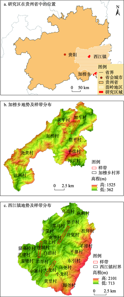
图1
研究区概况
注:基于自然资源部地图技术审查中心标准地图服务网站的标准地图(审图号:GS(2019)1822号)绘制,底图无修改。
Fig. 1
Overview of the study area
3 研究思路与研究方法
3.1 研究思路
黔东南苗岭山区的原住民,在山高坡陡、谷深河长的自然环境下建造了稻作梯田,并形成了世代相传的耕作实践方式和区域“森林-河流-稻田-村落”管理维护的土著文化知识体系[39]。而因自然环境千差万别、经济发展水平各异的地域差异,造就了各地土地利用模式和土地利用变化转型的复杂性和差异性。从整体看,研究区的稻作梯田存在三种自上而下的空间形态,即“林-田-村-河”(图2a)、“林-村-田-河”(图2b)、“林-田-村-田-河”(图2c)。山顶森林涵养水源,山腰村落、稻田相间分布,村落用于生产生活、稻田净水产粮、水系贯穿其中,形成“林-田-村-河”四素同构的独特垂直景观[40,41],生产、生活和生态空间交错分布的复合景观格局,对自然灾害的抵御能力较高。“四素同构”系统凭借一套完整的农业生态知识和农耕实践技术开展稻作农业,其和谐的“生产、生活、生态”三生关系是自然生态和人文传统的良好结合,也是稻田农耕文化历史的体现。
图2
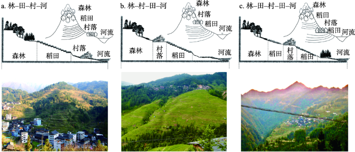
图2
研究区稻田村落空间组合类型
注:照片均为2020年7月至2021年12月作者拍摄。。
Fig. 2
Spatial combination types of rice field villages in the study area
通过解译研究区稻作梯田土地利用矢量图层,围绕稻田的数量规模、空间格局、土地利用活动及功能转型4个方面,分析稻田土地利用活动的时空演化特征。并在多样化人地关系演变背景下,依托独特的稻田空间分布结构及旅游开发历程,探讨研究区稻田多样化、差异化的可持续发展路径,优化稻作梯田农业生态系统长期稳定发展的可持续管理途径。
3.2 数据来源
本文的研究数据来源包括:① 基础矢量数据。基于ArcGIS 10.2软件对研究区多源影像进行几何校正、统一投影(将投影统一转换成计算面积比较精确的Albers投影)、地理配准及人机交互解译,依据《土地利用现状分类(GB/T21010-2017)》标准,结合具体情况将研究区土地利用分为在耕水田、在耕旱地、弃耕水田、弃耕旱地、园地、林地、草地、农村宅基地、商服用地、公共管理与公共服务设施用地、设施农用地、交通运输用地、河流水面、裸土地、特殊用地、坑塘水面16种类型,依次获得西江镇和加榜乡七期土地利用矢量数据。影像和地形图数据来源如表1所示,其中受影像数据可获取性影响,2015年影像部分缺失,因此以近似年份2013年作为补充。通过参考研究区乡镇土地利用资料、实地调查采样等进行精度验证,各时期总精度均达到83%以上,符合研究要求。从各时期土地利用数据中提取水田斑块作为本研究的主要数据。文中使用的DEM数据源于地理空间数据云,空间分辨率30 m,经计算后得到坡度图层。② 人口数据。研究使用的人口数据源于研究区地形图资料、乡镇政府及统计局、《2015年中国县域统计年鉴(乡镇卷)》和第五、第六、第七次人口普查公报。通过对研究区多年耕地稻田及人口的统计发现,山区精耕细作型水稻梯田农业,受社会经济快速发展影响,土地利用变化明显。其中以水稻为主的耕地利用多年间呈现出波动变化特征,这与该区域的自然地理环境和人类活动干扰关系密切(图3)。
表1 研究区不同时段影像源
Tab. 1
| 研究区 | 时间(年) | 影像来源 | 分辨率(m) |
|---|---|---|---|
| 西江镇 加榜乡 | 1977(西江镇)、1962(加榜乡) | 1:50000地形图 | 13 |
| 1986 | Landsat TM影像 | 30 | |
| 1991 | Landsat TM影像 | 30 | |
| 2000 | Landsat ETM、Aster影像 | 15 | |
| 2010 | Rapid Eye 影像 | 5 | |
| 2015(2013) | Google Earth影像 | 4 | |
| 2020 | Google Earth影像 | 4 |
图3
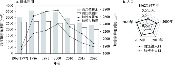
图3
研究区耕地利用及人口变化
Fig. 3
Arable land use and population change in the study area
3.3 研究方法
3.3.1 景观格局指数
景观格局指数是定量化表达景观信息的工具。基于研究区稻田数据,选择景观指数中类型尺度上的斑块总数(NP)、斑块总面积(CA)、平均斑块面积(MPS)、景观形状指数(LSI)和平均分维指数(MPFD)5个指标,采用Fragstats 4.2软件进行计算得出各指数值,具体的计算公式和生态学意义见参考文献[42]。
3.3.2 核密度估计
核密度估计分析方法通常用来反映要素在空间的分布特征。研究区稻田核密度值的高低表示稻田在研究区内聚集与分散的情况,直观反映了稻田的空间分布与演化特征[43]。公式如下:
式中:
3.3.3 土地利用转移矩阵
土地利用转移矩阵能够定量反映出各种地类之间的相互转移量及方向[44]。提取并绘制研究区稻田的转移矩阵图,可直观反映长时段内稻田的“源汇”变化情况。公式如下:
式中:
3.3.4 聚田比指数
为准确表现研究区稻田与聚落的空间组合关系,采用聚田比指数(
式中:
3.3.5 种植强度
借鉴种植强度指数PI(Planted Intensity)[46],计算稻田在不同高程和坡度下的种植强度,以反映其时空变化规律。公式如下:
式中:
3.3.6 样带分析
样带是指具有明显差异特征的线状区域[47]。为了展示研究区不同立体空间组合的稻作梯田模式在长时段内的演变特征,综合梯田的耕作半径、梯度差异等因素,分别选取了能代表研究区三种垂直结构演化特征的3条典型样带,宽度皆为400 m。
3.3.7 转型演变阶段划分
根据稻田前一时期向后一时期转移的主要地类、规模及驱动因素,将研究区稻田转移演变划分为两个阶段:一是受生产生活影响,以非农用地转稻田为主要特征的“生产用地导向阶段”;二是在维护生态安全、经济发展需求的推动下,将稻田转变为经果林等经济用地的“生态-经济复合用地导向阶段”。
4 结果分析
4.1 稻作梯田景观格局演化
表2显示了研究区稻田景观格局指数在类型尺度上的变化情况,各指数均处于动态变化过程,呈现出从研究初期显著变化至后期景观格局总体稳定的特征。西江镇和加榜乡的稻田斑块总数、景观形状指数及平均分维指数表现出“稳定增加”,平均斑块面积“稳定下降”的趋势,其中NP分别增加了2571个、2053个,LSI扩大了59.96、48.13,MPS减少了21.97、7.43。NP和LSI的快速增长既反映出人类对稻田的作用强度增大,也表明斑块形状的复杂度和破碎度加深。MPFD虽长期来都比较接近1,但随时间推移持续小幅增长,表明稻田的人为干扰影响程度有所降低。斑块总面积呈“波动变化”,稻田规模整体保持稳定,但面积缩小、斑块形状破碎化趋势逐渐凸显。西江镇稻田面积由1977年2635.04 hm2增长至1986年2706.28 hm2后逐期减少,加榜乡稻田面积在1962—2000年增加了693.33 hm2后面积持续减少。
表2 1962(1977)—2020年研究区稻作梯田的景观格局指数
Tab. 2
| 研究区 | 时间(年) | 景观格局指数(类型尺度上) | ||||
|---|---|---|---|---|---|---|
| 斑块总数 (NP/个) | 斑块总面积 (CA/hm2) | 平均斑块面积(MPS/ hm2) | 景观形状指数 (LSI) | 平均分维指数(MPFD) | ||
| 西江镇 | 1977 | 116 | 2635.04 | 22.7159 | 27.4645 | 1.1109 |
| 1986 | 2385 | 2706.28 | 1.1347 | 79.0019 | 1.1224 | |
| 1991 | 2518 | 2689.77 | 1.0682 | 81.8285 | 1.1226 | |
| 2000 | 2649 | 2537.52 | 0.9579 | 84.4802 | 1.1234 | |
| 2010 | 2720 | 2419.52 | 0.8895 | 88.1972 | 1.1259 | |
| 2015 | 2740 | 2176.69 | 0.7944 | 88.0300 | 1.1262 | |
| 2020 | 2687 | 2011.39 | 0.7486 | 87.4236 | 1.1275 | |
| 加榜乡 | 1962 | 209 | 1717.84 | 8.2193 | 25.3269 | 1.0878 |
| 1986 | 1582 | 2154.49 | 1.3619 | 59.3380 | 1.1093 | |
| 1991 | 1675 | 2228.71 | 1.3306 | 61.8508 | 1.1111 | |
| 2000 | 1930 | 2411.17 | 1.2493 | 66.2319 | 1.1110 | |
| 2010 | 2125 | 2064.20 | 0.9714 | 71.1045 | 1.1133 | |
| 2015 | 2133 | 1888.98 | 0.8856 | 71.1713 | 1.1136 | |
| 2020 | 2262 | 1787.48 | 0.7902 | 73.4551 | 1.1140 | |
4.2 稻作梯田核密度演变
图4
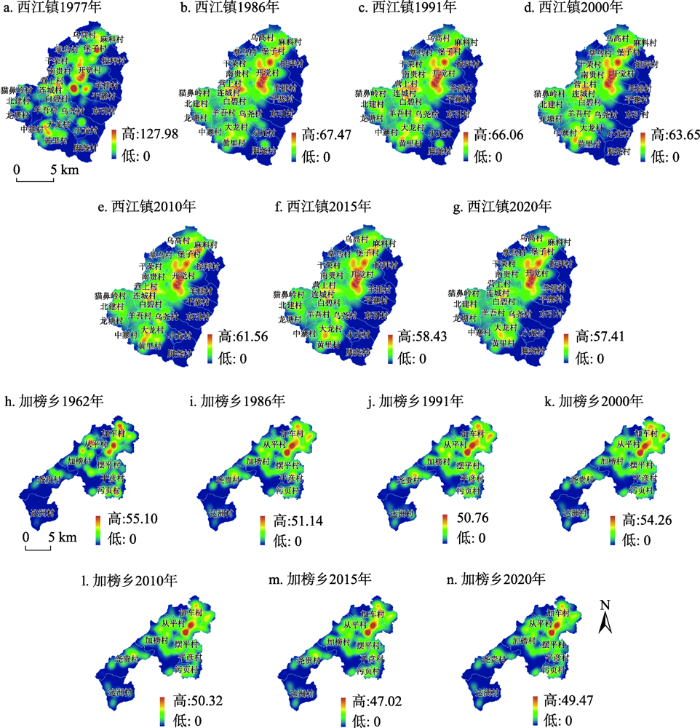
图4
研究区稻田核密度空间分布
Fig. 4
Spatial distribution of kernel density in rice fields in the study area
加榜乡稻田核密度由北至南集聚度不断降低(图4h~图4n),形成东、东北密度高,中部次之,南、西南部密度低的三段分布模式,大部分区域同样处于次低-次高密度区(图5b)。2015年前受加榜村、尧贵村及达洲村稻田面积扩张的影响,稻田核密度及重心往西南方扩散、微偏;2015年后西南部稻田逐渐萎缩退居于东北加车村、摆平村一带,重心往东北部回移,主要分布在东北交通便利、宜于发展乡村旅游的几个村。总体而言,两地稻田分布均呈“东北-西南”走向,受区域开发建设及稻田规划的影响大。如受西江镇西南部修建凯雷高速等交通建设影响,稻田向西南区扩展,而区域规划及稻田适应性等因素导致西江镇稻田逐渐集中在东北的开觉村一带,加榜乡则退居于东北的加榜村和加车村核心稻田区。
图5
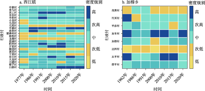
图5
研究区村域稻田核密度级别统计
Fig. 5
Statistics on kernel density level of rice fields for the village in the study area
4.3 稻作梯田在不同高程与坡度上的分布演变
根据研究区的高程情况,以200 m为梯度间隔,将高程分为6个等级;同时依据SL 190—2007《土壤侵蚀分类分级标准》[48],将研究区坡度分为6个等级:微坡(<5°)、较缓坡(5°~8°)、缓坡(8°~15°)、较陡坡(15°~25°)、陡坡(25°~35°)、急陡坡(>35°)[46],并统计分析不同高程坡度下稻田的分布情况及种植强度(图6)。由图6可知,西江镇稻田有89%以上集中在713~1113 m的适宜种植区,加榜乡整体海拔比西江镇稍低,92%以上的稻田集中在562~1162 m内。长期以来两地稻田种植高度均呈现出先往上下两头扩展,海拔区间拓宽,再由高处向低处收缩变化的趋势,同时各高程下的种植强度也呈现一致的发展趋势。
图6
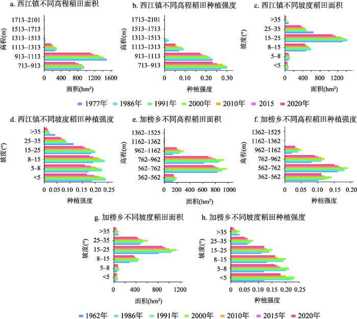
图6
研究区不同高程和坡度下稻田种植面积及强度
Fig. 6
Rice field planting area and intensity at different elevations and slopes in the study area
两地均有90%以上的稻田分布在8°~35°的坡度上。1986年之前,西江镇0°~25°间稻田面积呈弱增加趋势,种植强度持续上升;在1986年后,各坡度上稻田面积及种植强度呈弱减少趋势,其中受生产转移影响0°~25°间的种植强度明显降低。加榜乡稻田种植面积和强度从微坡至陡坡由2000年前强扩张,向2000年后弱减少转变;其中微坡至较陡坡上种植强度与急陡坡差异明显,如2000年微坡上的种植强度为26%,而急陡坡上的种植强度仅为3%。这主要受区域高强度生计需求的影响,在山高坡陡的地区开垦大量田地,之后由于城镇化发展,出现生产活动区间下移、农业活动多样化等变化,因此使得各高程和坡度上的稻田种植强度由显著加强向显著减弱转变。
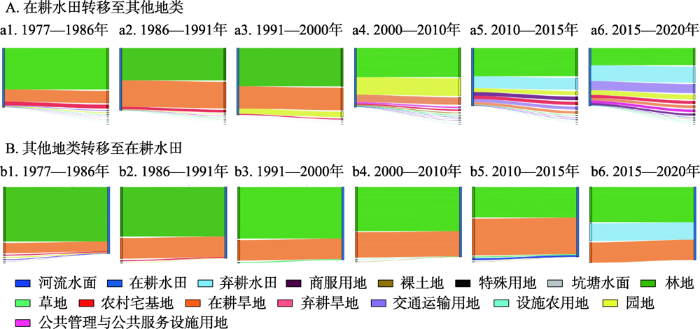
4.4 稻作梯田转型演变阶段分析
在长期土地利用转移变化中,占主导的是同类型间的稳定演变,因此不考虑同一地类间的转移变化,仅考虑稻田与其他地类间的转移情况。经研究发现,西江镇稻田经历了由“生产用地导向阶段”(1977—2000年)向“生态-经济复合用地导向阶段”(2000—2020年)的变化过程,其转移变化类型由复杂转向简单(图7)。“生产用地导向阶段”,稻田与林地间转出(1202.05 hm2)和转入(1300.99 hm2)的面积相差不大,但转换程度剧烈;稻田与旱地转出转入的面积分别为396.39 hm2、250.11 hm2;其他地类与稻田的转移面积均小于50 hm2,变化较平缓,总体上稻田面积缓慢减少。“生态-经济复合用地导向阶段”,稻田发生转移的总面积大幅下降,流失的稻田主要转变为林地(308.18 hm2)、园地(106.78 hm2)、建设用地(116.29 hm2)和撂荒地(107.74 hm2)。这一阶段受研究区经济快速发展的影响,新增的稻田开始减少对生态用地的占用,多是稻田与旱地之间的转换。
图7
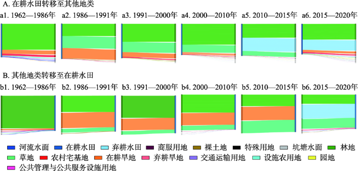
在加榜乡两个阶段中,稻田转移类型依然表现出由复杂向简单的变化过程(图8)。“生产用地导向阶段”(1962—2000年),稻田向林地的转变最为突出,转出683.44 hm2,转入1366.41 hm2;其次是稻田转为旱地(126.54 hm2)及草地(101.90 hm2);其他地类与稻田的转入和转出之间的面积均小于45 hm2,转换程度较平缓,总体上稻田面积不断扩张。“生态-经济复合用地导向阶段”(2000—2020年),稻田转出的面积持续增加(793.43 hm2)、转入的面积大幅下降(-1278.16 hm2)。流失的稻田主要转变为林地(443.64 hm2)、弃耕地(141.07 hm2)以及建设用地(17.22 hm2),林地转为稻田的面积在不断减少,多是弃耕地及草地新增为稻田。
图8
如图9所示,不同高程和海拔中,西江镇稻田随着时间推移呈现出由“生产用地导向阶段”大面积变化,向“生态-经济复合用地阶段”小幅稳定转变的特征。“生产用地导向阶段”,转移变化集中在高程1113 m以下、坡度8~35°之间,其中转入量高于转出量的区域集中在高程713~913 m、1113~1313 m和坡度25°以下,陡坡和急陡坡上不合理的耕作现象仍然较严重。“生态-经济复合用地阶段”,整体上各高程坡度段内稻田的转移量减少、整体面积无明显变化。
图9
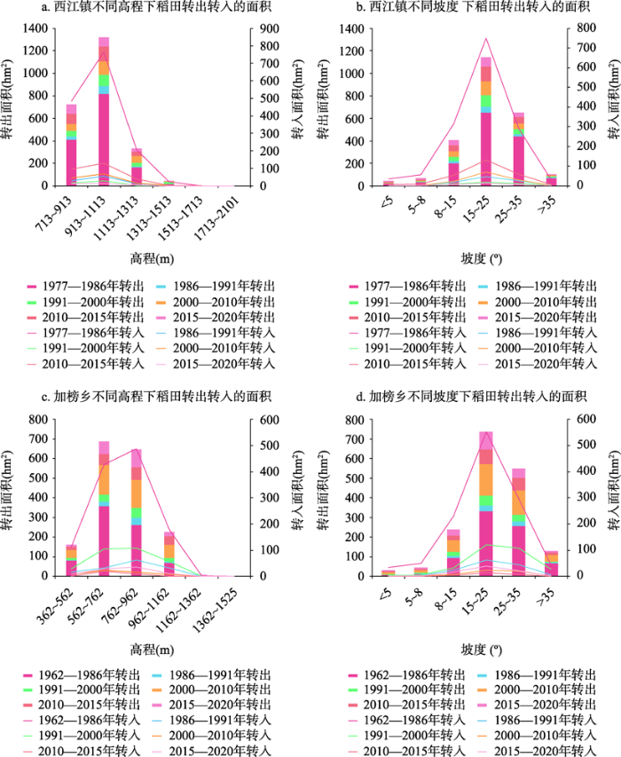
图9
研究区稻田在不同高程和坡度上转出转入的面积
Fig. 9
Area of rice field converted to and from other types of land at different elevations and slopes in the study area
加榜乡中稻田各时期的转移变化程度较西江镇稍平缓,且面积变化差距较小。“生产用地导向阶段”,稻田转移主要发生在海拔1162 m以下、坡度8~35°之间,且转入量均高于转出量。“生态-经济复合用地阶段”,各坡度上稻田以转出变化较为显著。虽然总体上加榜乡的稻田变化程度较西江镇缓和,但在坡度35°以上的区域稻田转出面积比西江镇多,说明加榜乡急陡坡度上的稻田退耕强度高于西江镇。
4.5 稻作梯田演变的人地关系响应
采用1 km × 1 km的格网为基本单元,分别计算每个格网内稻田面积与聚落面积的比值,得出研究区长时段内的稻田聚落耦合类型的空间分布及各类型占总面积的比例。
据研究区乡村总人口及耕地利用情况(图3)的长期变化发现,在2000年前因人口迅速增长的压力,导致对粮食的需求日益增加,而农业变革加速生产力的解放,同时加剧了开山种粮现象。这一时期,加榜乡呈现“人田同增”,西江镇稻田虽由“人田同增”向“人增田减”过渡但长期变化微弱,且主要为旱地波动增长。自2000年以后,农村劳动人口大量外出务工,总人口数下降,但在近期受全域旅游开发、新农村建设等政策的影响,推动经济发展同时吸引大批人口返乡务农经商。西江镇及加榜乡分别在2010年和2015年表现出由“人田同减”向“人增田减”的转变。
由表3聚田比占比可知,在西江镇的三种人地耦合关系类型中,人多田少型占比由1977年2.79%上升至2020年9.89%,扩张趋势明显;从图10各耦合类型的空间分布中可看出,该类型主要以中部南贵村和东引村为核心向南北两侧扩张。西江镇人地关系较为紧张的区域显著增加,局部人地矛盾逐渐凸显。相比西江镇,加榜乡中以人田均衡型变化突出,由1962年的13.63%上升至2020年的22.12%。人多田少型呈波动减少的特点,至2020年仅下降了0.26%,且该类型整体占比及变化幅度都不如西江镇强烈,在空间分布上先由东北、西南往中部集中,再由中部往东北、东南的区域扩张。总体而言,加榜乡以人少田多型向人田均衡型变化为主,区域内长期人地关系较西江镇更为缓和。
表3 研究区稻田-聚落各耦合类型面积占土地总面积比值
Tab. 3
| 研究区 | 耦合类型 | 时间(年) | ||||||
|---|---|---|---|---|---|---|---|---|
| 1962(1977) | 1986 | 1991 | 2000 | 2010 | 2015 | 2020 | ||
| 西江镇 | 人多田少型 | 2.79 | 3.18 | 2.63 | 7.65 | 7.09 | 8.77 | 9.89 |
| 人田均衡型 | 15.43 | 21.23 | 20.94 | 18.48 | 19.04 | 20.16 | 21.20 | |
| 人少田多型 | 9.97 | 22.48 | 23.32 | 20.76 | 20.03 | 19.47 | 18.43 | |
| 加榜乡 | 人多田少型 | 3.17 | 1.51 | 3.74 | 0.92 | 1.52 | 1.39 | 2.91 |
| 人田均衡型 | 13.63 | 19.60 | 20.71 | 15.16 | 15.65 | 17.94 | 22.12 | |
| 人少田多型 | 14.50 | 25.79 | 22.26 | 17.05 | 17.22 | 15.06 | 15.22 | |
(单位:%)
注:西江镇的研究起始年为1977年,加榜乡的研究起始年为1962年。
图10
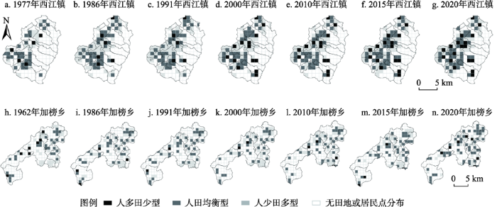
图10
研究区稻田-聚落耦合类型空间分布
Fig. 10
Spatial distribution of rice-settlement coupling types in the study area
4.6 稻作梯田在垂直空间上的转型演化
图11
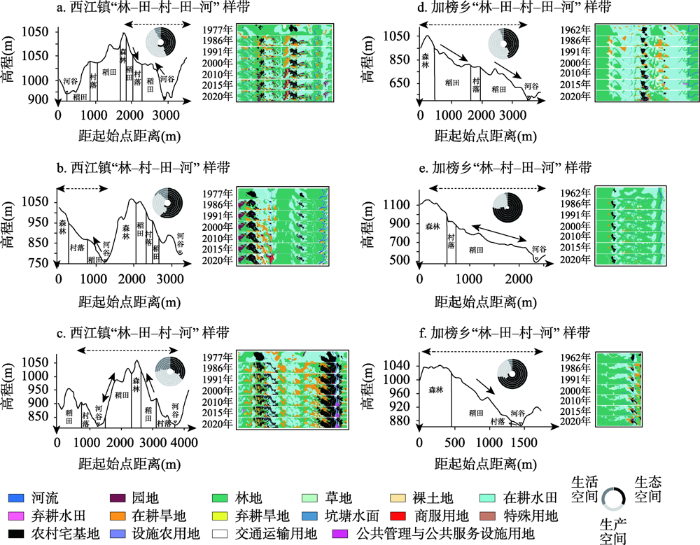
图11
典型“林-田-村”组合类型样带图
注:“三生空间”面积占比环形圈由内至外分别为1962年(西江镇1977年)、1986年、1991年、2000年、2010年、2015年及2020年7个研究时期。
Fig. 11
Transect of typical “forest-terraces-village” combination type
4.6.1 共性
① 两地整体稻田面积减少,远离村落的稻田易被遗弃并由林地取代,靠近村落的部分稻田多占用为建设用地或转为其他地类。农业生产空间逐步缩小,生活、生态空间日趋扩大,生产功能向生活、生态功能转变。② 从景观尺度上看,景观指数的长期变化情况表明,稻田景观朝破碎化、面积缩小及形状复杂化方向发展,景观类型由单一景观向复杂景观转变。稻田的连续性遭到破坏,以“林-村-田-河”组合类型的破碎化发展最明显,“林-田-村-田-河”“林-田-村-河”两个类型的稻田在一定范围内仍能保持良好的团聚性。③ 从立体空间上看,稻田分布整体由高海拔区域向低海拔区域下移;在坡度较陡的地区,稻田退耕或是撂荒后经自然演替转为林地等生态空间,具有明显的地形影响特征。
4.6.2 差异性
① 西江镇各组合类型的变化程度比加榜乡更剧烈,且景观类型的演变更为复杂。加榜乡三种组合类型长时段内仅以稻田面积缓慢减少为最大的变化特征,整体保持大规模的稳定耕作;西江镇中村落附近的稻田利用较明显,以转为园地、改成旱地或占用为建设用地为主。如北建村以发展“养殖业为经济生产主线”,开展“茶叶、青钱柳、朝天椒等特色蔬菜、土烟、黑毛猪等养殖产品”,脚尧村生态茶园、堡子村大棚蔬菜、龙塘村稻田养鱼等产业村、稻田村分化趋势明显的多样化稻田利用。② 受强烈的人类活动如交通等基础设施建设等的影响,割裂了稻田生产空间的连续性,其中西江镇的稻田破碎化程度较高。加榜乡稻田条带状、连片性景观突出,更有利于梯田发展,其中“林-田-村-田-河”“林-田-村-河”两种组合类型中稻田的连片性更高,“森林-稻田-村落-河流”四素同构的景观能得到良好的维持。
5 结论与讨论
5.1 结论
本文以黔东南少数民族山区西江镇和加榜乡山地稻作梯田为例,利用多年土地利用数据,从定性定量的景观指数、空间格局特征及生态系统功能变化等方面来研究稻作梯田景观的时空发展过程。结论如下:
(1)研究区稻田呈现规模小幅缩减,分布由高海拔、陡坡度向低海拔、缓坡度移动的特点。长期以保持大面积传统稻田耕作,局部逐渐演变为经果林、撂荒地、林地等景观为主要趋势,细碎化程度加深,景观连续性受损。
(2)稻田不同阶段土地利用方式的差异,促使稻田生态系统功能从“生产用地导向阶段”的生产生活保障功能,向“生态-经济复合用地导向阶段”的生态环境维护、社会经济发展多功能转变。
(3)西江镇和加榜乡人地关系变化复杂,总体上西江镇人地关系变化比加榜乡更剧烈。随着人口压力的增加,西江镇内“人多田少型”占比扩张的趋势显著,部分地区人地矛盾凸显。
(4)农旅一体化发展下“林-田-村-田-河”与“林-田-村-河”这两种组合类型稳定性较强。通过加大对稻田的管理修缮力度,并采取措施正确引导相应区域稻作梯田的旅游发展,以促进当地经济的可持续发展。
5.2 讨论
与中国山区土地利用转型中,由耕地扩张、林地收缩向耕地收缩、林地恢复的显性变化,及伴随而来的土地边际化和生态功能恢复的隐性转型相比[50,51],研究区稻作梯田在长期演变中仅呈现弱衰退性。其发展演变存在两个阶段,一是生产用地导向阶段(2000年前),受人口迅速增加、生计需求扩大的影响,不断加大对高山陡坡区的垦殖,导致生态系统退化,同时劳动力外迁造成土地资源浪费,进一步激化了区域的人地矛盾。二是在生态-经济复合用地导向阶段(2000年后),两地抓住“全域旅游、乡村振兴及生态文明建设”等政策契机,依托独特的山地稻田资源及少数民族文化发展生态旅游,推动区域由传统稻田种植农业不断向农旅复合型的多元化产业体系分化。出现农业生产用地破碎、萎缩,农业生产功能逐渐向生态[52,53]、经济功能转型的特点,农户生计多元化、兼业现象普遍,收入水平有显著提升。如2008年以前西江镇人均收入不足2000元,在全域旅游推进后,2017年旅游接待达600万人次、人均年收入达2.2万元,全寨90%的人口从事旅游服务[54],劳动人口的回流既促进区域经济发展也解决了村落的“空心化”特征。在山区稻田普遍经历劳动人口流失、土地抛荒、斑块破碎化及景观转型的过程中[55,56],与研究区出现的建设用地挤占稻田现象相比,云南中寨村近50年发展中建设用地从未挤占梯田[57];菲律宾的伊副高梯田区存在因旅游发展加剧森林砍伐的现象[58],而研究区水源涵养林长期得到较好的维护,如2017年,从江加榜百里梯田被列入贵州省首批12个森林康养基地[59];与哈尼梯田分布海拔(101~2745.8 m)及坡度(0~75°)均达到区域环境极限的形式而言[60],研究区稻田的垂直分布格局对生态环境的压力相对较小。
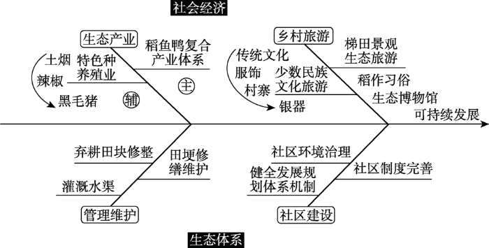
在乡村土地利用转型发展过程中,西江镇侧重发展传统村落及少数民族文化,通过大力修缮传统建筑、修建基础设施等挤占稻田空间,种植生态茶叶改变农耕属性等,从多个层面瓦解山区“四素同构”的生态系统,弱化了稻田文化生态系统的价值。加榜乡作为古老的“稻鱼鸭”共生体系、全球重要文化遗产地,立足农耕稻田发展梯田农业旅游,但由于发展晚、开发程度低等原因,目前仍依赖于梯田景观的观光旅游,而对传统稻田农耕文化、民族特征和传统村落等方面的融合开发不足,有较大的发展空间。同时,面对稻作梯田景观结构的破坏萎缩、传统农耕文化遗失、生态农产品产业链短缺及景观维护等生态系统问题[61⇓⇓-64],需要结合物质、精神及制度三维度上的鲜明文化特征综合治理[65]。由此,本文基于研究区的土地利用转型特点及区域发展特征的研究,总结了山区稻作梯田可持续发展路径(图12)。通过加强稻田的管理维护以及农旅文化的深度开发,建立“以农生旅,以旅带农”的长效发展路径,制定多利益主体和需求的社区发展策略,强化梯田社区的生态管理,多业态融合发展以维持“四素同构”生态系统的优势,充分发挥土地资源的多元价值,有效结合活态农耕文化与乡村振兴发展,实现乡村可持续发展目标。
图12
致谢
真诚感谢匿名评审专家在论文评审中所付出的时间和精力,专家对文中引言、研究思路、结果分析、结论与讨论方面均提出了宝贵的修改建议,使本文获益匪浅。
参考文献
梯田景观的历史分布及典型国际案例分析
DOI:10.13287/j.1001-9332.201702.010
[本文引用: 2]

梯田是在大面积多山地形和较高人口密度条件下产生的山区土地高效利用方式,广泛分布于世界各地,并且在不同的地理气候条件下产生了不同的类型,具有重要的生态价值和文化价值.梯田作为陡坡耕作区古老的土壤保持措施,有利于农业集约化,一般而言,梯田建设的目的是为了保持水土,减少产流产沙,改善立地环境,便于农业生产.在当前社会经济发展的背景下,大面积的梯田遭到荒废,不仅浪费了土地资源,还易导致严重的土壤侵蚀、坡面坍塌和土地退化.本文综述全球不同地理区域和自然环境条件下梯田的起源、发展以及分布特征,主要选择亚洲、欧洲、美洲和非洲四大重点区域进行系统介绍,并针对每一大洲内的典型国家做了案例剖析.在此基础上,深入探讨梯田建设、利用和荒废过程与气候变化、国家政策、人口变迁等因素的关系,最后针对目前梯田区存在的水资源紧张和梯田荒废退化两个严重问题,提出了尚需开展的研究工作,以期为梯田的可持续利用与管理提供参考依据.
History and distribution of terraced landscapes and typical international cases analysis
层登横削高为梯举手扪之足始跻: 话说我国的梯田
Climbing the heights horizontally and turning the heights into the ladders, and you start to rise with your hands and feet: Talking about the terraced fields of our country
Effects of farming terraces on hydrological and geomorphological processes
Areview
Global synthesis of the classifications, distributions, benefits and issues of terracing
哈尼梯田的农业文化遗产特征及其保护
Remarks on the application for world cultural heritage of the Hani Paddy-Rice terraces
哀牢山自然生态与哈尼族生存空间格局
The natural ecology of Ailao Mountain and the living space pattern of the hani nationality
Ecological and social evaluation of landscape in a rural area with terraced paddies in southwestern Japan
Effects of Traditional Ecological Knowledge on the Drought-Resistant Mechanisms of the hani Rice Terraces System
梯田生态系统服务与管理研究进展
Progress of the ecosystem services and management of terraces
Impacts of temperature and rainfall variation on rice productivity in major ecosystems of Bangladesh
崇义客家梯田生态系统可持续发展综合评价
Comprehensive evaluation of sustainable development of the hakka terrace ecosystem of Chongyi
全球水稻梯田生态系统服务研究进展
Research progress and prospects on ecosystem services of global rice terrace
哈尼梯田文化景观及其保护研究
A study on the cultural landscape of Hani's terrace and its protection
稻作梯田农业文化遗产保护研究综述
A review of conservation of rice terraces as agricultural heritage systems
Values and conservation of Honghe hani rice terraces system as a GIAHS Site
The significance of traditional culture for agricultural biodiversity-experiences from GIAHS
遗产视角下的元阳哈尼梯田旅游开发: 基于国内外梯田旅游发展模式的研究
Yuanyang Hani terrace's tourism development in the view of heritage: Based on the model research on domestic and foreign terraces' tourism development
梯田与旅游: 探索梯田可持续旅游发展路径
Terraces and tourism: Exploring sustainable tourism development of rice terraces
Tourist preferences for agricultural landscapes: a case study of terraced paddy fields in Noto Peninsula, Japan
Integration of abandoned lands in sustainable agriculture: The case of terraced landscape re-cultivation in mediterranean island conditions
加强梯田景观综合研究,促进山地系统可持续发展: 第十届全国景观生态学学术研讨会梯田景观专场述评
Strengthen the comprehensive research on terraced landscape and promote the sustainable development of mountain system: Comment on the terraced landscape of the 10th National Symposium on Landscape Ecology
Terrace extraction based on remote sensing images and digital elevation model in the loess plateau, China
哈尼梯田土地利用空间格局及其变化的信息图谱研究
Research on information Tupu of land use spatial pattern and its change in Hani terraces fields
Land-use changes in Slovenian terraced landscapes
Investigation on farmland abandonment of terraced slopes using multitemporal data sources comparison and its implication on hydro-geomorphological processes
河北涉县旱作石堰梯田农业文化遗产景观特征及演变
Landscape characteristics and evolution of agricultural heritage of dryland stone-ridge terraced field in Shexian, Hebei province
Global consequences of land use
China's agricultural land use change and its underlying drivers: A literature review
Rural land use transition of mountainous areas and policy implications for land consolidation in China
How do population decline, urban sprawl and industrial transformation impact land use change in rural residential areas? A comparative regional analysis at the peri-urban interface
Revitalize the world's countryside
A conservation approach of Globally Important Agricultural Heritage Systems (GIAHS): Improving traditional agricultural patterns and promoting scale-production
Land terracing for new vineyard plantations in the north-eastern Spanish Mediterranean region: Landscape effects of the EU Council Regulation policy for vineyards' restructuring
Hydrological and erosive consequences of farmland abandonment in Europe, with special reference to the Mediterranean region: A review
Abandonment of agricultural land and its consequences
Assessing the impact of the green revolution, 1960 to 2000
基于多功能理论的中国乡村发展多元化探讨: 超越”现代化”发展范式
DOI:10.11821/dlxb201502007
[本文引用: 1]
传统的乡村现代化发展范式和地理学关于乡村的区域差异研究之间存在缝隙,不足以为快速演化分异的乡村地域发展提供直接理论支撑。本文引入西方近20年来逐渐兴起的多功能农业与多功能乡村理论,从新的视角观察思考中国乡村多元化发展的目标、路径及对策。首先从经济、社会和环境三个方面反思中国乡村现代化的基本历程与得失,以及西方国家乡村现代化产生的问题,指出传统的农业农村现代化发展在很大程度是以牺牲乡村环境和乡村社会机理脆弱化为代价的,也造成了乡村经济对外部支持的过度依赖,仅仅强调“现代化”发展范式显然是不够的;然后简要介绍了国外多功能农业与多功能乡村理论;在此基础上,从功能角度提出中国农业农村发展的多元目标,推演探讨农业农村发展的区域差异化路径及对策。
Diversified agriculture and development in China based on multifunction theory: Beyond modernization paradigm
There is a big gap between general rural modernization paradigm and huge empirical rural geography studies. This gap results in impotent development strategies on regionally differentiated countryside. Based on multifunctional agriculture theory and multifunctional rural theory which emerged in Western World as a new paradigm, this paper discusses the multiple objectives, differentiated pathways and policies of agriculture and rural development in China. Firstly, this paper reflects the problems and challenges caused by modernization paradigm in rural China on economic, social, and environmental aspects, as well as that of western developed countries. It can be concluded that conventional agricultural and rural modernization is developed largely at the expense of rural environment, social fabric and economic viabilities. Obviously, "modernization development paradigm" alone is not enough for healthy agricultural and rural development in such booming economy as China. A better paradigm should be developed which takes economic development, social justice and environmental sustainability into account at the same time. After a brief review of multifunctional agriculture theory and multifunctional rural theory overseas, the multiple objectives of agriculture and rural development in China are put forward. These multiple objectives, however, should not and could not be a burden on rural space indiscriminatingly due to the enormous differentiation of natural and socio-economic conditions. Thus, the final but main part of this paper envisions the differentiated pathways and policy portfolios of agricultural and rural development in China from the perspective of territorial division.
贵州黔东南稻作梯田的历史文化及生态价值
Historical culture and ecological value of rice terraces in Southeast Guizhou
An indigenous knowledge-based sustainable landscape for mountain villages: The Jiabang rice terraces of Guizhou, China
哈尼梯田湿地生态系统的垂直特征
The vertical characteristics of ecosystem of Hani's terrace paddyfield in Yunnan, China
Changes of phosphate and ammonium nitrogen in irrigated waters of hani terrace wetlands along the elevation gradients
县域”三生空间”格局与功能演变特征及可能影响因素分析: 以江西婺源县为例
Evolution characteristics and possible impact factors for the changing pattern and function of “Production-Living-Ecological” space in Wuyuan County
关于区域土地利用变化指数模型方法的讨论
Discussion on the index method of regional land use change
长株潭地区聚落空间演化及其与耕地的空间关系研究
Study on settlement spatial evolution and its space relationship with arable land in Chang-Zhu-Tan region
中老缅交界地区橡胶种植的时空格局及其地形因素分析
Spatial-temporal analysis of rubber plantation and its relationship with topographical factors in the border region of China, Laos and Myanmar
中国县域城镇化的空间特征与形成机理
DOI:10.11821/xb201208001
[本文引用: 1]
本文综合运用样带、地统计、地理探测器等多种研究方法, 分析了1990 年以来中国县域城镇化的时空特征及形成机理。研究表明:①中国县域城镇化水平时空动态的差异特征显著, 北方边境县域高城镇化和东部沿海县域高城镇化形成的“人字形”空间形态逐渐凸显;以武汉都市圈为中心的两湖地区、成渝地区、关中—天水经济区的县域城镇化水平提升较快, 西南地区、青藏高原地区保持较低的城镇化水平;②2000 年以来中国县域城镇化水平及其变化速度的区域差异逐渐缩小, 陇海兰新线、长江沿线、北方边境、106 国道、东部沿海样带县域城镇化差异明显;县域经济发展阶段、固定资产投资、离中心城市距离、二三产业水平、农民人均纯收入、人口密度是影响县域城镇化空间分异的主要因素, 同时粮食生产主导定位、非农业人口统计口径、城镇设置标准等因素也影响县域城镇化水平及发展过程。未来城镇化发展应遵循地域差异, 凸显主导功能, 推进优化与重点发展区的集约型城镇化、耕地与粮食主产区的分流型城镇化、生态与水源保护区的迁移型城镇化, 以及园区与城镇近郊区的融入型城镇化, 实现城乡土地资源集约利用, 促进城镇化进程中人—地—业耦合与协调发展。
The spatial characteristics and formation mechanism of the county urbanization in China
The spatial and temporal characteristics and the formation mechanism of the county urbanization in China since 1990 were analyzed systematically, using the methods including regional differences, transect and geography detectors. Results show that the temporal and spatial differences of the county urbanization were significant. The "herringbone" shape region pattern of high county urbanization was gradually highlighted, which were made by the counties along the north border and in eastern coastal areas. The county urbanization process of some regions were accelerated and enhanced, including Wuhan metropolitan region, Chengdu-Chongqing region and Guanzhong-Tianshui region. The low county urbanization level was maintained in Southwest China and Qinghai-Tibet Plateau regions. The differences of urbanization and the change rate of county urbanization were converged in China after 2000, but the rate has slowed down since 2000. The county urbanization trend of transects were significantly different, including Lianyungang-Lanzhou railway and Lanzhou-Urumqi railway transects, the Yangtze River transect, the border of north China transect, 106 National Road transect, and the eastern coastal transect. There are many factors affecting county urbanization, mainly including economic development stage, the level of secondary and tertiary industries, rural net income per capita, population density, leading position of grain production, demographic statistics and special arrangements for counties. The high county urbanization in northern border regions was a typical type of statistical unrealistically high urbanization. In the future county urbanization development should follow the geographical differences, highlight its leading function, and adopt multiple urbanization development models such as promoting urbanization intensively in key urban economic development areas, separating urbanization in cropland and grain producing areas, migrating urbanization in ecological and water resource protection areas, suburban areas and urban-based urbanization and other leading county urbanization patterns.
SL190-2007土壤侵蚀分类分级标准
SL190-2007 Classification Standard of Soil Erosion
中国”三生空间”分类评价与时空格局分析
DOI:10.11821/dlxb201707013
[本文引用: 1]
本文在探究“生产—生活—生态”三生空间理论内涵的基础上,分析了土地利用功能与土地利用类型的辩证关系,依据土地利用现状分类国家标准,建立了三生空间分类与评价体系,揭示了1990-2010年间中国三生空间的格局及其变化特征。结果表明:① 生产空间主要分布在胡焕庸线东南侧的主要城市群及粮食主产区,其扩张区域主要分布于东北平原、新疆西北、宁夏、兰州—西宁、四川盆地、环渤海、长三角、厦漳泉、珠三角等地区,缩小区域主要分布在黄土高原、呼伦贝尔大草原、江汉平原、闽南丘陵等地区;② 生活空间主要集中在全国主要城市及城市群,整体上呈现“东高西低、北高南低;大分散、小集聚”的空间格局,其扩张过程表现为环渤海、长三角、珠三角三大城市群的大规模、区域式扩张和各主要省会城市的小规模、点状式扩张。③ 生态空间主要分布在胡焕庸线西北侧,整体呈现“西高东低,南高北低”的空间格局;④ 工业化、城镇化是中国三生空间变化的基本动力,西北和东北地区的农田开垦、华北平原和三大城市群的城镇化建设、黄土高原的退耕还林等是导致三生空间区域差异的主要原因。本文可以为三生空间的分类规划和优化决策提供参考依据。
Classification evaluation and spatial-temporal analysis of “production-living-ecological” spaces in China
This paper created a land use classification system of production-living-ecological spaces based on analyzing the theories of production-living-ecological spaces and commanding the dialectical relationships between land use types and land use functions. The classification system perfectly connected to the state standard of land use classification. Based on this system, we examined the spatial and temporal patterns of production-living-ecological spaces in China between 1990 and 2010. The results showed that: (1) The production spatial pattern almost unchanged between 1990 and 2010, and the production spaces were mainly distributed in the southeast of the Hu Huanyong Line, including Northeast China Plain, northwest Xinjiang, Ningxia, Lanzhou-Xining, Sichuan Basin, Bohai Rim, Yangtze River Delta, Xiamen-Quanzhou-Zhangzhou, and Pearl River Delta, where China's urban agglomerations and main grain production areas were located in. (2) Living spaces were mainly distributed in China's urban agglomerations and cities, showing a spatial pattern of "high in the east and north regions, while low in the west and south regions". Its spatial expansion varied in different areas. Large-scale expansion of living spaces appeared in the Bohai Rim, Yangtze River Delta and Pearl River Delta, while small-scale and point-type expansion in the major provincial capitals. (3) Ecological spaces were mainly distributed in the northwest of the Hu Huanyong Line, showing a spatial pattern of "high in the west and south regions, while low in the east and north regions". The expansion of ecological spaces were mainly in the Loess Plateau, Hulun Buir Glassland and Tianshan Mountains, while the reduction of ecological spaces were mainly in the Northeast China Plain, North China Plain, Yangtze River Delta, Pearl River Delta, Ningxia and Xinjiang. (4) Industrialization and urbanization were the basic driving powers of changes of China's production-living-ecological spaces. The main reasons for regional spatial differences across China included farmland cultivation in Northwest and Northeast China, rapid urbanization in North China, Bohai Rim, Yangtze River Delta and Pearl River Delta, and reversion of farmland to forestland in the Loess Plateau. This research was valuable for the studies on classification and evaluation of production-living-ecological spaces.
中国山区农村土地利用转型解析
DOI:10.11821/dlxb201803009
[本文引用: 1]
山区土地开发及其导致的资源环境问题是农业社会人地关系紧张的体现,工业化、城镇化进程中劳动力转移减轻了山区农村土地的人为扰动,由此驱动土地利用发生转型,引发一系列自然和社会经济效应。按照“土地利用转型—驱动力—效应—响应”的分析框架,剖析中国山区农村土地利用转型的特征和规律,提出山区农村土地整治的响应措施。研究表明:① 山区农村土地利用转型体现出土地利用形态在长期变化过程中的趋势性转折,显性形态转型即由农业社会的耕地扩张和林地收缩演变为城镇化进程中的耕地收缩和林地恢复性增长,隐性形态转型即伴随上述过程发生的土地边际化及生态功能恢复;② 社会经济因素主导山区农村土地利用转型过程,劳动力转移引发土地人为扰动减轻是直接驱动力,务农机会成本上升、恶劣的生存环境等引发劳动力转移的因素是更为根本的驱动力;③ 山区农村土地利用转型降低了土地生态系统脆弱性并提高了其生态安全屏障功能,其社会经济效应应聚焦山区农村发展与农户生计安全层面,并亟需实证研究的支撑;④ 当前山区农村土地利用转型是自然恢复和生态优化的良性过程,有着经济社会发展的必然规律,山区农村土地整治要顺应其土地利用转型规律,目标导向从耕地数量增加转向生态环境保护与社会经济福祉协同提升。
Land use transition of mountainous rural areas in China
In agricultural society, the cultivation of mountainous land was a representative of intensified contradiction between human and land which resulted in water loss and soil erosion. With the rapid urbanization and industrialization in poverty-stricken mountainous areas, the labor emigration relieves this contradiction significantly, and leads to land use transition, which results in a series of natural and socio-economic changes. This research built an analysis framework of "Land use transition - driving mechanism - effects - responses" in mountainous land use transition and then put forward the further direction of mountainous land reclamation. The results indicate that: (1) The tendency change of land use morphology was the core of rural land use transition in mountainous areas. The expansion of cropland, as well as the contraction of forest land in agricultural society, has changed to the abandonment of cropland and the expansion of forest land is the main characteristic of the dominant land use morphology transition. Land marginalization and land ecological functional recovery are the main characteristics of the recessive land use morphology transition in mountainous areas. (2) Socio-economic factors are the primary driving forces during the mountainous land use transition. Labor emigration is the direct driving forces. Meanwhile, the rising costs of farming opportunities, and the harsh living environment that lead to labor emigration are the root cause for mountainous land use transition. (3) The transition of rural land use in mountainous areas reduces the vulnerability of land ecosystem and improves its ecological security barrier function. The advantages and disadvantages of its socio-economic effects should focus on rural development of mountainous areas and the livelihood of farmers, and need to be supported by empirical and quantitative researches. (4) The transition of land use in rural areas is a benign process of natural restoration and ecological optimization. The rural land remediation in mountainous areas should conform to the law of land use transition, and the target orientation will shift from the increase of cultivated land to the synergies of ecological and environmental protection.
中国山区耕地利用边际化表现及其机理
DOI:10.11821/dlxb201805002
[本文引用: 1]
耕地利用边际化是当前中国山区土地利用主要变化趋势。利用《全国农产品成本收益资料汇编》资料,本文首先分析2003年以来农业劳动力价格快速上涨的背景下,中国农业生产成本的结构变化以及农户的响应,并对比平原和山区农户对劳动力成本上升的响应方式及程度的差异,发现平原地区能够通过大规模的农业机械替代减少劳动投入,进而有效减少劳动力价格上升所带来的影响,而山区因地形条件限制,劳动生产率提升相对缓慢,并与平原地区的差距不断扩大,导致农业劳动力成本占比不断上涨。随着劳动力成本的快速上涨,中国山区耕地边际化特征明显,以玉米为代表的种植业净利润在2013年普遍降至零以下。2000年以来,中国山区土地利用和植被变化表现为耕地面积减少、森林面积增加、NDVI指数增强,而且在省级层次上,山区县范围NDVI变化率与耕地和森林面积变化率分别具有很强的负相关(r = -0.70)和正相关(r = 0.91),证实了中国山区耕地当前边际化的发展态势。基于以上分析,本文最后对务农机会成本上升、农业劳动力快速析出背景下的山区耕地利用边际化机理进行了总结。这一研究有助于深入认识山区耕地撂荒和森林转型的发展过程。
Economic characteristics and the mechanism of farmland marginalization in mountainous areas of China
Farmland marginalization has become the main trend of land-use change in the mountainous areas of China. Using the China Agricultural Production Costs and Returns Compilation (annual survey data of major agricultural production costs and earnings at national and provincial levels), this paper first analyzed the changes in the cost structure of agricultural production and the farmers' responses, under the context of the rapid rise in agricultural labor prices since 2003, and further compared the responses from the mountainous and plain regions. We found that farmers on the plains have reduced their labor input effectively through intensive use of agricultural machinery, which has minimized the impact of the increase in labor price. However, it is a severe challenge for farmers in the mountainous areas to use the same method due to the rough terrains. Thus, the agricultural labor productivity in these areas has increased relatively slowly, causing a widening gap in agricultural labor productivity between the two regions. With the rapid rise in labor costs, the marginalization of cultivated land in the mountainous areas is evident. In 2013, the profit of agricultural production in mountainous China, which takes maize cultivation as a representative, has fallen below zero. Since 2000, the land-use and land cover change in these areas has been characterized by the reduction of farmland area, reforestation, and the enhancement of the NDVI value. The high correlation between the NDVI change rate and the ratio of change in farmland (r = -0.70) and forest (r = 0.91) areas in mountainous areas at provincial level from 2000 to 2010, attests to the trend of farmland marginalization there. Finally, according to the analysis results, we summarized the mechanism of such marginalization against the backdrop of the rapid increase in the opportunity cost of farming and the sharp fall of agricultural labor forces. This study contributes to a deep understanding of the development process of farmland abandonment and forest transformation in the mountainous areas of China.
Landscape change and the sustainable development strategy of different types of ethnic villages driven by the grain for green program
Cultural ecosystem services from the afforestation of rice terraces and farmland: Emerging services as an alternative to monoculturalization
西江模式: 贵州民族文化旅游产业发展的样本
Xijiang Model: A sample of the development of Guizhou National Cultural Tourism Industry
梯田保护利用的演化逻辑及外力影响因素: 以元阳哈尼梯田为例
DOI:10.13284/j.cnki.rddl.003326
[本文引用: 1]
以世界文化遗产的云南红河哈尼梯田为例,基于元阳县自然资源局的土地利用的空间矢量数据,利用地理信息系统技术提取2013-2018年元阳县与梯田核心景区的土地利用类型信息,分析梯田耕作时空演变的总体特征和变化趋势,选取级差地租理论解释梯田耕作的演化逻辑,并通过实地调研说明政府的外力干预效果。结果表明:1)梯田核心区的耕地比例大于整个元阳县的耕地比例,且不同于元阳县内旱地面积大于水田面积,核心区内的水田面积为旱地面积的一倍,表明核心区的水田比非核心区保护得更好;2)在没有外力干预的自然情况下非核心区与核心区水田分别呈现改旱和撂荒趋势,民族内部的文化力量难以可持续抗衡这种变迁。而政府作为市场失灵的调控机关,在遗产保护任务和政治利益激励的诉求下,干预了核心区的梯田演变过程,通过提高级差地租Ⅱ实现核心区的土地增值,集中加大对核心区的资源要素投入,从而有效延缓了梯田遗产消失或变更的进程;而非核心区由于缺乏政府有力的干预,梯田正呈现逐渐消失的趋势。
Evolution of terrace farming and external factors of terrace protection measures: A case study of Hani terraces
As an important global cultural heritage, terraced fields are currently facing abandonment and being transformed into dry land. This study explores the influence of a foreseeable external intervention on terrace protection measures by using the Honghe Hani Terraces in Yunnan, which are a world cultural heritage site, as an example. According to the land use vector data obtained by the Yuanyang County Natural Resources Bureau, the land-use information of Yuanyang County and the core scenic area of the terraced fields during 2013-2018 were extracted through the geographic information system technology to further explore the influence of external forces on the protection of paddy fields in the core area of terraced fields. This paper uses extreme rent theory to explain the evolutionary logic of terrace farming, explaining the effect of external force intervention by the government through field research. This study has two primary results. First, the proportion of cultivated land in the core area of terraces was larger than that in Yuanyang County; the paddy field section in the core area is twice the size of the dryland area, indicating that the paddy field in the core area is better protected than that in the non-core area. In terms of the spatial and temporal dynamic evolution of land types, the area of dry and construction lands increased the most in Yuanyang County from 2013 to 2018, while that of the paddy fields and garden land showed a decreasing trend. It can also be concluded that the intensity of farming activities on the paddy fields decreased throughout Yuanyang County, with paddy fields drying to some extent. However, the land type in the core area of the terraced fields was relatively stable; it is speculated that the large-scale traditional agricultural production mode has been retained. Second, according to the current land-use situation, the influence of external force intervention on terrace farming was analyzed by consulting different theories, field studies, and interviews. Differential rent theory summarizes the two forms of land rent model without outside intervention and under natural conditions. Land value is only included in differential rent Ⅰ as financially rational male villagers prefer the more economical dry land crops (non-core), while OuDeGai drought or migrant workers prefer abandoned crops (core). The land value is only reflected in the differential rent I. As a rational economic man, the villagers prefer to grow dry land cash crops (to change drought in non-core areas) or to go out for work (abandon farming in core areas). When considering urbanization, internal national cultural forces (local attachment and insecurity) show inertia resistance and vulnerability, rendering it difficult to guarantee the long-term cultural inheritance of terraced fields when relying on traditional forces. In contrast, based on its political responsibilities and the demand of the people, the government intervened in the core area in a prescient way. By hosting major events applying for World Cultural Heritage to attract investment, the land value in the core area has been increased, terraces in the core area are being successfully protected and managed, and disappearance or alteration of this cultural heritage has been effectively delayed. However, in the non-core area, there is no foreseeable external force intervention, and the terraced fields show a trend of gradual disappearance.
红河哈尼梯田世界文化景观遗产的遥感监测与土地覆盖变化
Remote sensing monitoring and land cover change of the world cultural landscape heritage in Honghe Hani terrace, China
哈尼梯田遗产区乡村聚落景观及其演变: 以云南元阳全福庄中寨为例
以2013年6月列入世界文化景观遗产的红河哈尼梯田文化景观区内的乡村聚落景观——云南省红河州元阳县全福庄中寨为研究对象,通过实地调查、访谈和GIS制图分析等方法,分析了哈尼聚落景观的组成要素与内部结构、景观空间格局及其演变。结果表明:1)哈尼聚落景观的边界以实际存在的树带和树门来分离精神世界里人和鬼魂的地域空间;聚落内部受地形和血缘关系影响形成组团式结构,传统民居以蘑菇房为代表;2)聚落具有独特的文化景观要素——用于祭祀和祈福的寨神林、用于娱乐和晾晒粮食的磨秋场以及用于生活取水和祭祀的水井,它们体现了哈尼族崇拜自然的宗教文化体系;3)哈尼聚落景观的空间格局具有森林在上、村落居中、梯田在下、水系贯穿其中的特点,聚落的选址正是基于景观空间格局与适宜人居和便于到达梯田耕作的特点选定;4)哈尼聚落景观在空间演变方面具有独特的分寨和“地名连名”制特点,聚落用地在50 a间扩大了近10倍,而蘑菇房的周边和内部结构则出现了多向演变的趋势,其中现代砖混房屋的比例正呈急剧增加趋势;5)哈尼聚落景观作为哈尼梯田文化景观遗产的组成要素之一,在维系遗产稳定性方面具有重要作用。因此,如何传承与保护哈尼聚落景观成为当务之急,未来应注重聚落空心化等的研究。
The rural settlement landscape and its evolution in the Hani rice terrace culture landscape areas: A case study of Quanfuzhuang Middle Village, Yuanyang County, Yunnan
<p>This paper takes the rural settlement landscape of Hani rice terrace culture landscape areas as the research object, and makes a case study on Quanfuzhuang Middle village, Yuanyang County, which was inscribed on the World Cultural Landscape in June of 2013. Through field surveys, interviews, and GIS mapping analysis method, the paper analyzes the elements, the internal structure, landscape spatial structure and evolution of Hani village landscape. The results are as follows: 1) the boundary of Hani village landscape is the actual existing tree band and tree door, which is used to separate the human spiritual world and ghost in the geographical space; because of the group structure affected by the terrain and kinship, the settlements’ traditional houses are represented by mushroom house; 2) the settlements have some unique cultural landscape elements: the sacred groves used for sacrifice and pray, <em>Moqiuchang</em> used for entertainment and drying grain, and water wells used for domestic water and sacrifice, which all reflect the system of religious culture, that is nature worship; 3) Hani village landscape takes on a spatial pattern: the forest in the above, the village in the middle, the terrace in the below, and the rivers run through them, so the locations of settlements are based on the landscape pattern, suitable for living and accessible to the terrace; 4) the spatial evolution of Hani village landscape is characterized by separated stockade and hyphenated place names, land use of the settlements has expanded by nearly 10 times in the last 50 years, and the perimeter and internal structure of mushroom house turn on a trend of multi-directional evolution, in which the proportion of modern mixed brick room shows a sharp increase trend; 5) as one of the elements of Hani rice terrace cultural landscape, Hani village landscape plays an important role in maintaining the stability of heritage. Therefore, top priority should be given to inheritance and protection of the Hani village landscape, and the future research should focus on settlement hollow phenomenon.</p>
基于生态恢复和文化回归的梯田景观格局重建: 以菲律宾科迪勒拉高山水稻梯田景观复兴为例
Reconstruction of landscape pattern on terraces based on the theory of ecological restoration and cultural regression for mountain rice terraces in the Philippines Cordillera region
黔东南森林康养与体育旅游融合的PEST分析
PEST analysis of the integration of forest health and sports tourism in Southeast Guizhou
哈尼梯田垦殖生态极限的当代意义探讨
Study on the contemporary significance of ecological cultivation limit of Hani terraces
Erosion and terrace failure due to agricultural land abandonment in a semi-arid environment
Hydro-geomorphological consequences of the abandonment of agricultural terraces in the Mediterranean region: Key controlling factors and landscape stability patterns
Traditional cultivation terraces are one of the most ancient and conspicuous agricultural landscapes in mountain and hilly regions of the Mediterranean basin. Spreading out from Asia, the first terraces in the Mediterranean region date from the Bronze Age and the classical Hellenic and Roman periods, reaching their greatest spatial extent during the eighteenth and nineteenth centuries. Under optimum management, these systems contribute to the conservation of soil and water resources by increasing infiltration and decreasing sediment yield. However, traditional management and cultivation ceased on many terraced landscapes of the northern-shore Mediterranean countries during the twentieth century, with variable results. An extensive bibliographic review and meta-analysis was carried out to explore the main effects of land abandonment of Mediterranean agricultural terraces on local hydrological and geomorphological processes. Our results point to the development of vegetation cover and degradation of terraced structures (e.g., walls, terrace risers, channels) as the main critical factors controlling the hydrological behaviour (i.e., runoff production and hydrological connectivity) of abandoned terrace systems. Severe geomorphological problems, in the form of intense surface erosion, aggressive piping and gullying, occurred under special climatic (semi-arid climate), lithologic (dispersive marls) and structural (high vertical hydraulic gradient) conditions. Dense colonization by vegetation proved to be of major importance for controlling surface erosion. Vegetation, however, showed a limited capacity to control the activity of mass movements in most cases. Mass movements in the form of small soil slips primarily affected long-abandoned terraces in hillslope concavities and valley bottom positions that concentrate (surface and subsurface) water fluxes and show recurrent soil saturation. In humid terraced landscapes characterized by high hillslope gradients and terrace risers, the most devastating effects of mass movements took place in the form of debris slips and terrace cascading landslides triggered by extreme rainfall. A variety of management options (non-intervention, stewardship of natural rewilding processes and active rehabilitation) can be applied, depending on vegetation development potential, site hydro-geomorphic vulnerability and local socio-economic interests. Effective conservation approaches will be required to preserve the environmental, socio-cultural and historical values of these ancient anthropogenic landscapes. (C) 2019 Elsevier B.V.
Landscape pattern optimization approach to protect rice terrace Agroecosystem: Case of GIAHS site Jiache Valley, Guizhou, Southwest China
Impact of erosion in the taluses of subtropical orchard terraces
环太平洋梯田文化圈论
On the terrace cultural cycle around the Pacific
